Showing 870 items
matching road traffic
-
 Victoria Police Museum
Photograph (police car)
... A mini having mounted the curb into oncoming traffic... having mounted the curb into oncoming traffic on Beach Road ...A mini having mounted the curb into oncoming traffic on Beach Road, with a Ford Falcon Camera Car parked beside it and a Volkswagen driving towards it in the background. Circa 1969police vehicles; motor transport branch; motor transport section; wireless patrol; ford falcon q car; camera car -
 Eltham District Historical Society Inc
Photograph, Hugh Fisher, Eltham Shire Council Staff, Shire Centenary Anniversary, 6 April 1971
Formal photograph of group of men and women employed by the Shire of Eltham, to commemorate the Shire Centenary 6 April 1971. Photograph taken at the rear of the Council Offices, Main Road, Eltham 1971 Eltham Shire Council Staff Photo (SEPP_4050 and SEPP_40511) L-R Back Row: N. Stuart (Engineering), N. Campbell (Engineering), W. Oakley (Engineering), R. McIldowie (Engineering), D. Welch (Engineering), G. Pullen (Accounts), J. Bleazby (Rates), P. Sturtevent (Engineering), B. Hill (Engineering), F. Harrington (Engineering) Third Row: C. Harris (Building), M. Van Ewijk (Accounts), Miss C. Casella (Administration), Miss D. Curran (Rates), M. Howard (Administration), Dennis McKay (Engineering), Mrs L. Crockett (Accounts), A. Liepa (Engineering), G. Newton (Building), Mrs N. Davis (Administration), I. Leach (Health), Mrs F. Conyers (Rates), B. Wright (ranger), I. Caig (Traffic By-Laws Officer) Second Row: J. Constable (Accounts), J. Parsons (Health), Mrs J. Baker (Health), P. Hoare (Engineering), Miss R. Spearman (Rates), D. Golder (Engineering), Mrs R. Cox (Administration), H. Masefield (Fire Proper Officer), A. Birch (Engineering), Sister L. Cameron (Health), Russell Yeoman (Engineering), T. Phyland (Engineering) Front Row (seated): Miss D. Vreulink (Administration), D. Lovatt (Health), Mrs H. Dixson (Accounts), M. Fowler (Rates), Mrs L. Harris (Administration), C. Gaudion (Health), M. Watson (Shire Secretary), A. Roberts (Administration), Miss J. Featherby (Engineering), M. Verhoeven (Engineering), Mrs M. Lethlean (Engineering), I. McDonald (Rate Collector), Mrs W. Klooster (Engineering), Mrs C. Bell (Engineering) Absent: John McDonald (Shire Engineer) This photo forms part of a collection of photographs gathered by the Shire of Eltham for their centenary project book, "Pioneers and Painters: 100 years of the Shire of Eltham" by Alan Marshall (1971). The collection of over 500 images is held in partnership between Eltham District Historical Society and Yarra Plenty Regional Library (Eltham Library) and is now formally known as 'The Shire of Eltham Pioneers Photograph Collection.' It is significant in being the first community sourced collection representing the places and people of the Shire's first one hundred years.Digital image Print 20 x 25 cmInscribed A2207A (SEPP_4050) 2nd version inscribed A2207B (SEPP_4051)a. birch, a. liepa, a. roberts, b. hill, b. wright, c. gaudion, c. harris, council, council staff, council-staff, d. golder, d. lovatt, d. welch, dennis mckay, eltham-shire-council, f. harrington, g. newton, g. pullen, h. masefield, i. caig, i. leach, i. mcdonald, j. bleazby, j. constable, j. parsons, john mcdonald, m. fowler, m. howard, m. van ewijk, m. verhoeven, m. watson, miss c. casella, miss d. curran, miss d. vreulink, miss j. featherby, miss r. spearman, mrs c. bell, mrs f. conyers, mrs h. dixson, mrs j. baker, mrs l. crockett, mrs l. harris, mrs m. lethlean, mrs n. davis, mrs r. cox, mrs w. klooster, n. campbell, n. stuart, p. hoare, p. sturtevent, r. mcildowie, russell yeoman, shire of eltham centenary, shire of eltham pioneers photograph collection, sister l. cameron, t. phyland, w. oakley -
 Eltham District Historical Society Inc
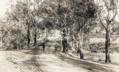
Negative - Photograph, Warrandyte Bridge over River Yarra, c.1910
View of the 1875 timber trestle bridge over the Yarra River reproduced from a newsprint image. Also known as Anderson's Creek (Road) Bridge A contract was accepted for William Elliot to erect a bridge over the Yarra River at Warrandyte on Anderson's Creek Road and other improvements for £1,331.6.2 - Gazette No. 143. Tuesday, November 13th 1860 - http://gazette.slv.vic.gov.au/view.cgi?year=1860&class=general&page_num=2161&state=V&classNum=G143&id=). The bridge was washed away by floods in 1863. It was replaced with a taller timber trestle structure in October 1875, designed and built by C.S. Wingrove, Shire Clerk, Engineer and Surveyor for Eltham Shire Council. A replacement for this bridge was commenced in 1955 to cope with increasing traffic and this structure was widened in 2018 to meet further traffic demands. Argus (Melbourne, Vic. : 1848 - 1957), Thursday 23 September 1875, page 7 ________________________________________ THE WARRANDYTE BRIDGE. The ceremony of formally opening the newly erected bridge over the Yarra at Ander-son's Creek was performed on Monday last, in the presence of the members of the Eltham and Bulleen shire councils whose territories it joins, and a goodly number of the residents of the district. The task was delegated to Mr. Cameron, M.L.A., who, after a few introductory remarks declared the bridge to be opened, and christened it the " Warrandyte Bridge." The party then adjourned to Grant's Hotel, where a cold collation had been prepared. The chair was taken by the president of the Eltham shire (Mr. John Bell) and the vice chair by Mr. Kent, a member of the Bulleen council. Mr Robert Williamson proposed "Success to the bridge," coupling with it the name of Mr. Cameron, to whose exertions was in the main to be attributed the erection of that structure which was an ornament to the district and would prove of great service to both sides of the river. Mr. Cameron, in responding, alluded to the great difficulties, mainly of a pecuniary nature, that had been encountered in carrying out the project, and which had only been got over by their united efforts and by the liberal spirit in which the late Commissioner of Roads had dealt with the case. The healths of the contractor and the engineer were also drunk. The bridge is a trussed timber one, resting on yellow box piles sunk into the solid rock, each pier being weighted with 50 tons of stone. The abutments consist of dry stone walls, 6ft. thick at the base, and tapering to 3ft. on the top, the face of the work having a batter of 1 to 1. The length of the bridge is 308ft., there being four openings in the centre of 66ft. each, and two at the ends of 20ft. each. The width in the clear is 9½ft., and the height from the bed of the river about 33ft. The approaches comprise 1,100 cubic yards of earthwork, and the formation of 48 chains of sideling, the whole cost of the work, which was carried out under the direction of the engineer to the Eltham Shire Council, being £1,413.This photo forms part of a collection of photographs gathered by the Shire of Eltham for their centenary project book,"Pioneers and Painters: 100 years of the Shire of Eltham" by Alan Marshall (1971). The collection of over 500 images is held in partnership between Eltham District Historical Society and Yarra Plenty Regional Library (Eltham Library) and is now formally known as the 'The Shire of Eltham Pioneers Photograph Collection.' It is significant in being the first community sourced collection representing the places and people of the Shire's first one hundred years.Digital image 4 x 5 inch B&W Neg B&W Print 12.5 x 9 cmsepp, shire of eltham pioneers photograph collection, warrandyte, bridge -
 Eltham District Historical Society Inc
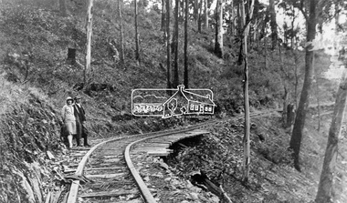
Negative - Photograph, Timber Tramway at Wright's Falls, Kinglake District, c.1920
Man and woman stand beside timber tramway track at Wright's falls Kinglake. The tramway was constructed alongside the road to support the large traffic in firewood between the mountains to Whittlesea. The Wright family owned the land on which the Falls were situated and were sold for a penny an acre according to a Wright family story. This photo forms part of a collection of photographs gathered by the Shire of Eltham for their centenary project book,"Pioneers and Painters: 100 years of the Shire of Eltham" by Alan Marshall (1971). The collection of over 500 images is held in partnership between Eltham District Historical Society and Yarra Plenty Regional Library (Eltham Library) and is now formally known as 'The Shire of Eltham Pioneers Photograph Collection.' It is significant in being the first community sourced collection representing the places and people of the Shire's first one hundred years.Digital image 4 x 5 inch B&W Negshire of eltham pioneers photograph collection, kinglake, timber tramway, wrights falls -
 Eltham District Historical Society Inc
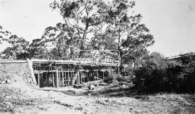
Negative - Photograph, Construction of the new concrete bridge over the Diamond Creek on Main Road, Eltham, c.May 1926
Construction of the new concrete bridge over the Diamond Creek on Main Road, Eltham, c.May 1926. Viewed from present day Wingrove Park. The original long suspension bridge over the Diamond Creek on Main Road at Eltham collapsed during flooding of the Diamond Creek on October 13 and 14, 1923. The original bridge was built around 1840 for the coach road when Cobb & Co.'s coach was the only conveyance between Eltham and Melbourne. Widespread damage was done in Melbourne and surrounding areas by floods resulting from the overflow of the Yarra at many points along its banks. A temporary bridge rigged up was severely damaged by the flooding of the creek and was closed to vehicular traffic in April 1924. A new concrete bridge was constructed to replace it and by May 1926 all the concrete piles and abutments had been completed. The bridge was finally completed and opened for traffic in September 1926, almost three years after it initially collapsed.This photo forms part of a collection of photographs gathered by the Shire of Eltham for their centenary project book,"Pioneers and Painters: 100 years of the Shire of Eltham" by Alan Marshall (1971). The collection of over 500 images is held in partnership between Eltham District Historical Society and Yarra Plenty Regional Library (Eltham Library) and is now formally known as the 'The Shire of Eltham Pioneers Photograph Collection.' It is significant in being the first community sourced collection representing the places and people of the Shire's first one hundred years.Digital image 4 x 5 inch B&W Neg Print 9 x 12.5 cmshire of eltham pioneers photograph collection, eltham, eltham lower park, main road bridge, eltham south, bridge, diamond creek (creek), wingrove park, bridge construction -
 Eltham District Historical Society Inc
Negative - Photograph, Bridge on Main Road, Eltham, c.1890
Possibly produced as a postcard. Caption in lower right hand corner reads: Bridge (at) Main Road Eltham. The long wooden suspension bridge over the Diamond Creek on Main Road at Eltham collapsed during flooding of the Diamond Creek on October 13 and 14, 1923. The original bridge was built around 1840 for the coach road when Cobb & Co.'s coach was the only conveyance between Eltham and Melbourne. Widespread damage was done in Melbourne and surrounding areas by floods resulting from the overflow of the Yarra at many points along its banks. A temporary bridge rigged up was severely damaged by the flooding of the creek and was closed to vehicular traffic in April 1924. A new concrete bridge was constructed to replace it and by May 1926 all the concrete piles and abutments had been completed. The bridge was finally completed and opened for traffic in September 1926, almost three years after it initially collapsed. Viewed from Antoinette Boulevard looking northwest towards Falkiner Street. The building in the distance believed to be Souters Cottage. On the far right on the very edge of the road verge are two Eucalypt trees, one of which is believed to be the large dead trunk still standing in present day.This photo forms part of a collection of photographs gathered by the Shire of Eltham for their centenary project book,"Pioneers and Painters: 100 years of the Shire of Eltham" by Alan Marshall (1971). The collection of over 500 images is held in partnership between Eltham District Historical Society and Yarra Plenty Regional Library (Eltham Library) and is now formally known as the 'The Shire of Eltham Pioneers Photograph Collection.' It is significant in being the first community sourced collection representing the places and people of the Shire's first one hundred years.Digital image 4 x 5 inch B&W Neg Black and white print 35mm positive transparencyshire of eltham pioneers photograph collection, eltham, main road bridge, eltham south, bridge, diamond creek (creek), significant tree, souters cottage, eltham lower park, main road, sepp -
 Eltham District Historical Society Inc
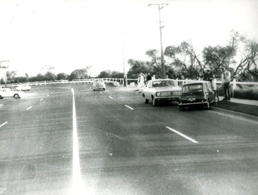
Photograph, Peter Pidgeon, Intersection of Main Road and Fitzsimons Lane; northbound traffic routed up Main Road during Bolton Street upgrade, Eltham, 13 November, 2017, 13/11/2017
... traffic routed up Main Road during Bolton Street upgrade, Eltham... Intersection of Main Road and Fitzsimons Lane; northbound traffic ...North bound lane closure. Born Digitalbolton street, bolton street upgrade, eltham, streets, main road, fitzsimons lane -
 Eltham District Historical Society Inc
Photograph - Photograph postcard, The Rose Stereograph Company, View at Eltham, Vic. Postcard sent from Ernest and family to Joe, 3 May 1936, c.1920
Postcard sent from Ernest and family to Joe, 3 May 1936. Original photo estimated to be circa 1920. Looking west across the original Main Road Bridge and the Diamond Creek from near the intersection of Antoinette Boulevard. To the right of the bridge appear to be orchard trees in flood waters. The long wooden suspension bridge over the Diamond Creek on Main Road at Eltham collapsed during flooding of the Diamond Creek on October 13 and 14, 1923. The original bridge was built around 1840 for the coach road when Cobb & Co.'s coach was the only conveyance between Eltham and Melbourne. Widespread damage was done in Melbourne and surrounding areas by floods resulting from the overflow of the Yarra at many points along its banks. A temporary bridge rigged up was severely damaged by the flooding of the creek and was closed to vehicular traffic in April 1924. A new concrete bridge was constructed to replace it and by May 1926 all the concrete piles and abutments had been completed. The bridge was finally completed and opened for traffic in September 1926, almost three years after it initially collapsed. The Rose Series P. 4346 Postcards scanned from the collection of Michael Aitken on loan to EDHS, 13 Feb 2018Digital file only Postcards scanned from the collection of Michael Aitken on loan to EDHS, 13 Feb 2018michael aitken collection, postcards, main road bridge, main road, eltham, antoinette boulevard, diamond creek (creek), eltham south -
 Orbost & District Historical Society
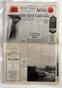
newspaper, Snowy River Mail, June 14 1978
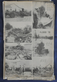
Orbost has been subject to major floods throughout its history, such as those which left the town isolated in 1934, 1952, 1971 and 1978. It is recorded that the Snowy River broke its banks and flooded the flats 104 times between 1884 and 1978. Extensive flooding in Eastern Victoria during June 1978, caused widespread damage to roads, road closures and hazards to traffic, particularly over the Queen's Birthday holiday weekend.Since 1890 the Snowy River Mail has been the local newspaper of the Orbost district.This local paper has been the means by which readers in Orbost were able to learn about newsworthy events and issues in their local community for over a century. This paper is a contemporary record of a significant event in Orbost's history of flooding.A newspaper, Snowy River Mail, which contains black / white photographs of the 1978 floods in Orbost.orbost-floods-1978 -
 Ringwood and District Historical Society
Book, Borough of Ringwood Receipt Book Register
Bound book "Borough of Ringwood Receipt Book Register" (includes numerous clubs, organisations, council services, traffic infringements, and more) -
 Orbost & District Historical Society
black and white photographs, C 1981
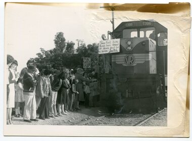
The Bairnsdale-Orbost railway was opened in 1916 to serve the agricultural and timber industry. Because of the decline in traffic and heavy operating costs, the line was finally closed in August, 1987. The closure of this railway was a controversial issue at the time with many public protests in the district. Protesters stood in front of a VR locomotive holding up signs with " SAVE FUEL JOBS ROADS LIVES ORBOST MR HAMER DON"T LET THIS HAPPEN SAVE RAIL" Others held placards with "DON"T CUT OFF ORBOST" and "We the Children demand our ????secure railway"This item is associated with the history of the Orbost-Bairnsdale railway line and therefore reflects the role that the rail line played in the social and economic history of Orbost. The closure of the line was a significant event in Orbost's history.Seven black / white photographs related to the closure of the Orbost Railway Line.orbost-railway east-gippsland-railway protests-rail-closure -
 Orbost & District Historical Society
black and white photographs, 25.11.1976
These photographs were taken on November 25, 1976 at the official opening of the current Snowy River road bridge. Included in the photographs are: John Duggan; Pat Hall, C.R.B. chairman, R.E.V. Donaldson (3240.7) and J.A.Rafferty, the state minister for Transport, who cut the ribbon (3240.8). Di Young and Cheryl Dusting (3240.9) distributed souvenir information pamphlets to official guests. The Snowy River road bridge is one of four built as part of the 8.4 km project spanning the Orbost flood plains. The Snowy River bridge and another over the nearby Ashbys Gulch are among the 10 longest bridges in Victoria, being the eighth and fifth longest respectively. The new bridge removed through traffic from Orbost township crossing the Snowy River 45 m downstream of the old bridge.This bridge is the fourth to provide a crossing to the township of Orbost. (info from CRB NEWS No. 34. DECEMBER, 1976) These photographs are pictorial records of a significant event in Orbost's history.Eleven black / white photographs all related to the official opening of the current Snowy River Bridge. Details are in catalogue folder.snowy-river-bridge -
 Orbost & District Historical Society
black and white photographs, February 17 1971
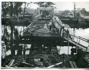
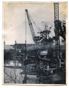
After the damage from the February 1971 floods at Orbost when the abutment to the Snowy River road bridge was washed away a Bailey bridge, portable, pre-fabricated, truss bridge, was put into place to ensure town access, the C.R.B. rebuilt the approach to the bridge driving new piles and constructing the Bailey bridge. They worked late into the night under flood lights to ensure the link from the Orbost township to the Princes Freeway would be open to traffic as soon as possible.These photographs are pictorial records of a significant event in the history of Orbost.Three black / white photographs of a Bailey bridge being erected across a river. 3245.1 and 3245.2 are the same. bailey-bridge orbost-snowy-river-bridge bridge-orbost -
 Orbost & District Historical Society
black and white photographs, 1975
These are photographs of the construction of the current cement road bridge across the Snowy River at Orbost. Construction of the bridges commenced in January 1975, with an expectation to open the bridge across the Snowy River as soon as possible. Less than two years later, on 25 November 1976, the bridge across the Snowy River was opened to traffic, allowing the old bridge to be demolished. The remainder of the Orbost Bypass, both the floodplain crossings and the eastern section around the township itself, was declared ‘Princes Freeway’ and opened to traffic in December 1977. (ref http://mrv.ozroads.com.au)The opening of this Snowy River Bridge was an important development in the accessibility to the township of Orbost. These photographs record its construction.Two black / white photographs showing the construction of a road bridge across a river. 3257.1 shows piles being dropped beside the bridge, 3257.2 is of the early stages of construction of this bridge.snowy-river-bridge-orbost road-construction-orbost bridge-orbost -
 Ringwood and District Historical Society
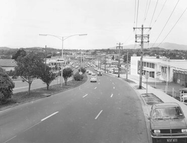
Photograph, Maroondah Highway West, Ringwood- 1974. Easterly view from Heatherdale Road, 1974
Black and white photographWritten on backing sheet, "Coming into Ringwood, 1974".bill patterson holden, 1970s, car dealers, main streets, suburban life, traffic -
 Orbost & District Historical Society
newspaper clippings, June 1978
Orbost has been subject to major floods throughout its history, such as those which left the town isolated in 1934, 1952, 1971 and 1978. It is recorded that the Snowy River broke its banks and flooded the flats 104 times between 1884 and 1978. Extensive flooding in Eastern Victoria during June 1978, caused widespread damage to roads, road closures and hazards to traffic, particularly over the Queen's Birthday holiday weekend. These newspaper articles are contemporary records of a significant event in Orbost history.A collection of black/white newspaper clippings relating to the 1978 flood in Orbost. Some are original articles. others are photo-copies. They appear to be from the Snowy River Mail newspaper.floods-orbost-1978 newspaper-articles -
 Flagstaff Hill Maritime Museum and Village
Vehicle - Spring Cart, Late 19th to early 20th centuries
A spring cart is a two-wheeled, one-horse cart, often with the driver standing up to drive it, and otherwise seated on a simple seat. Carts like this one had springs to make the ride smoother. It is a lighter version of a farm dray and is sometimes called a spring dray. Spring carts were often used on farms for carrying loads. In the towns, some businesses used a spring cart for deliveries of bread, milk and other goods. The carts would be used for travel and for families going on outings and picnics. Visitors to Flagstaff Hill Maritime Village from 1986 to 1992 would enjoy watching a Clydesdale horse named Duke as he worked around the village with his driver Pat McGowan. He would be hitched to a wagon or to this lightweight spring cart or sometimes he would pull the wagon with the cart attached as a trailer. The cart was used for maintenance, carting loads of timber or stone around the site or from town to Flagstaff Hill. Sometimes Duke and the cart would take visitors for cart rides around the Village. Pat McGowan was known for his restoration of horse-drawn vehicles including this spring cart. He already had 40 years of horse handling experience when he began looking after Duke, feeding and harnessing him and driving the horse and cart around the Village. Pat’s dog ‘Yabbie’ would often join them. In August 1992 Duke had to be put down. Warrnambool Veterinary Clinic and other fund-raisers began well-supported appeals and the beloved horse was replaced by a Clydesdale also named Duke (the second), who began work in late October 1992. He, like his predecessor, had a quiet temperament and was comfortable in the traffic. The spring card is an example of vehicles used on farms, for business delivery and for domestic transport in the late-19th and early-20th century. This cart is of note for being associated with the Clydesdale horse Duke which pulled the cart around Flagstaff Hills in the 1980s and 1990s, representing transport of that period.Spring cart; two-wheeled cart with shallow box tray and plank seat bolted across the front. Wheels have metal rims and fourteen (14) wooden spokes. A plank is bolted from side to side. A decorative metal step is on the cart's left and has acorn cut-out shapes in the plate. Both wheels have a brake block that is operated by a lever on the cart's right. The cart has eight-leaf suspension from front to back. The box tray is painted blue and has decorative pale yellow detail. Each shaft pole has has a handle fitting on it. (Horse equipment with the cart is a leather covered, straw filled collar.) flagstaff hill, flagstaff hill maritime museum and village, warrnambool, maritime museum, maritime village, great ocean road, shipwreck coast, springcart, spring cart, jingle, horse-drawn cart, one horse cart, two-wheeled cart, dray, spring dray, wagon, transportation, travel, cart, duke, clydesdale, pat mcgowan, delivery cart, yabbie, cartwright, horse-drawn vehicle, transport, horse cart -
 Marysville & District Historical Society
Booklet - Information booklet, Ann Thomas, Wilks Creek Bridge, 1993
A history of the Wilks Creek Bridge and its connection to the Yarra Track.Paperback. Front cover has an old photograph of the Wilks Creek Bridge.non-fictionA history of the Wilks Creek Bridge and its connection to the Yarra Track.wilks creek bridge, yarra track, narbethong, marysville, victoria, clement wilks, wood's point goldfields, jordan goldfields, john monash, monash and anderson, 2009 black saturday bushfires -
 Marysville & District Historical Society
Photograph (Item) - Colour photograph, Pre 2009
A colour photograph of the Wilks Creek Bridge near Marysville in Victoria.A colour photograph of the Wilks Creek Bridge near Marysville in Victoria. The Wilks Creek Bridge is a former timber and bluestone road bridge on the Yarra Track, and is located just off the Black Spur route, between Narbethong and Marysville, Victoria, Australia. It was built in 1870 to the design of colonial Public Works Department engineer Clement Wilks as part of the construction of a new road to the Woods Point and Jordan Goldfields. Like many bridges of the period, it had a timber superstructure employing squared beams supported by struts and straining pieces, on cut bluestone abutments. The bridge was remodelled around 1900 by engineer John Monash of the famous bridge-engineering firm of Monash and Anderson. It was last used for heavy vehicular traffic in 1980 following the realignment of Marysville Road, and was left to decay until its demolishment in 2008. All timber traces of the bridge were destroyed in the 2009 Black Saturday fires. The handcrafted bluestone masonry wingwalls and abutments, especially shaped to receive timber struts, rate among the earliest of its kind surviving intact in Victoria.wilks creek bridge, yarra track, narbethong, marysville, victoria, clement wilks, wood's point goldfields, jordan goldfields, john monash, monash and anderson, 2009 black saturday bushfires -
 Marysville & District Historical Society
Photograph (Item) - Black and white photograph, 1993
A black and white photograph taken at the re-opening of the Wilks Creek Bridge picnic area and launch of Ann Thomas' book Wilks Creek Bridge.A black and white photograph taken at the re-opening of the Wilks Creek Bridge picnic area and launch of Ann Thomas' book Wilks Creek Bridge. The Wilks Creek Bridge is a former timber and bluestone road bridge on the Yarra Track, and is located just off the Black Spur route, between Narbethong and Marysville, Victoria, Australia. It was built in 1870 to the design of colonial Public Works Department engineer Clement Wilks as part of the construction of a new road to the Woods Point and Jordan Goldfields. Like many bridges of the period, it had a timber superstructure employing squared beams supported by struts and straining pieces, on cut bluestone abutments. The bridge was remodelled around 1900 by engineer John Monash of the famous bridge-engineering firm of Monash and Anderson. It was last used for heavy vehicular traffic in 1980 following the realignment of Marysville Road, and was left to decay until its demolishment in 2008. All timber traces of the bridge were destroyed in the 2009 Black Saturday fires. The handcrafted bluestone masonry wingwalls and abutments, especially shaped to receive timber struts, rate among the earliest of its kind surviving intact in Victoria.wilks creek bridge, yarra track, narbethong, marysville, victoria, clement wilks, wood's point goldfields, jordan goldfields, john monash, monash and anderson, 2009 black saturday bushfires -
Marysville & District Historical Society
Document (Item) - Heritage Report, Biosis Research Pty Ltd, Heritage Report-Dismantling of Wilks Creek Brdige Deck Marysville, Unknown
A heritage report on the dismantiling of the Wilks Creek Bridge deck in Marysville in Victoria.A heritage report on the dismantiling of the Wilks Creek Bridge deck in Marysville in Victoria. The Wilks Creek Bridge is a former timber and bluestone road bridge on the Yarra Track, and is located just off the Black Spur route, between Narbethong and Marysville, Victoria, Australia. It was built in 1870 to the design of colonial Public Works Department engineer Clement Wilks as part of the construction of a new road to the Woods Point and Jordan Goldfields. Like many bridges of the period, it had a timber superstructure employing squared beams supported by struts and straining pieces, on cut bluestone abutments. The bridge was remodelled around 1900 by engineer John Monash of the famous bridge-engineering firm of Monash and Anderson. It was last used for heavy vehicular traffic in 1980 following the realignment of Marysville Road, and was left to decay until its demolishment in 2008. All timber traces of the bridge were destroyed in the 2009 Black Saturday fires. The handcrafted bluestone masonry wingwalls and abutments, especially shaped to receive timber struts, rate among the earliest of its kind surviving intact in Victoria.wilks creek bridge, yarra track, narbethong, marysville, victoria, clement wilks, wood's point goldfields, jordan goldfields, john monash, monash and anderson, 2009 black saturday bushfires -
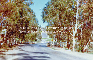 Eltham District Historical Society Inc
Photograph, Wattletree Road Bridge, Eltham, c. August 1977, 1977
Traffic island at intersection is lined with white-painted bluestone edging which originally was part of the Eltham lock-up situated at 728 Main Road. The bluestone has since been re-used (from late 1980s) at the rear of 728 Main Road to form the garden bed in car park. Colour photographeltham, infrastructure, main road, shire of eltham infrastructure, wattletree road bridge, bridge -
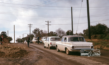 Eltham District Historical Society Inc
Photograph, Fred Mitchell, Traffic delays at the corner of Bridge Street and Main Road, Eltham, during duplication works, 1968, 1968
Roadworks for duplication of Main Road.Digital copy of colour photographfred mitchell collection, 1968, eltham, bridge street, main road, road construction, duplication -
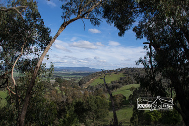 Eltham District Historical Society Inc
Photograph, View from Breakneck, Yarra Glen, 27 August 2016, 27/08/2016
"Until 1865, all wheeled traffic to the Upper Yarra District passed through Christmas Hills along present day Ridge and Muir roads, then followed the hazardous course of "The Breakneck" (now Breakneck Road) to the valley below. To slow the descent of wagons, logs are said to have been dragged behind. In 1865, an easier route was opened on the south side of the Yarra River, and led to the birth of Lilydale". - Christmas Hills Past and Present (Yarra Glen District Historical Society), 2004.Digital copy of colour photographfred mitchell collection, 2016, breakneck, yarra glen -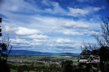
Glen Eira Historical Society
Document - SHELFORD GIRLS’ SCHOOL AND KINDERGARTEN
This file contains 2 items relating to plans for the buildings and grounds of the school: 1/2 copies (1photocopy, 1 original) of the July 1982 ‘Shelford Planning Brief: Church of England Girls’ Grammar School’, written by the Caulfield City Council. The brief describes the history of the school, its current grounds and plans for future expansion. It also contains 2 ground plans: one of the existing school site and 1 of the planned future school site. 2/1 copy of a City of Caulfield Council memo regarding the July 1982 Shelford Planning Brief, describing small changes to the brief. Written by J. Floyd, 24/11/1982.city of caulfield, shelford c.e.g.g.s., caulfield, glen eira road, st mary’s anglican church, seymour road, allison road, ‘helenslea’, hood justice mr, hood crescent, st mary’s parish hall, helenslea road, education, gymnasiums, schools, students, secondary schools, primary schools, bentleigh, classrooms, car parks, libraries, traffic, playgrounds, teachers, windows, plans, shelford planning brief, kilvington planning brief, shelford church of england girls’ grammar school, floyd j, fences, kilvington baptist girls’ -
 Ringwood and District Historical Society
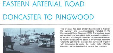
Newsletter, Eastern Arterial Road Doncaster to Ringwood Environment Effects Statement Summary Brochure - November 1987
8-page A4 size brochure issued by Road Construction Authority reporting on the proposed extension of the Eastern Freeway between Doncaster and Ringwood. Topics include Community Consultation, Initial Four Lane Development, Estimated Capital Costs, Traffic Effects, Public Transport, Landscape Creek and Visual Aspects, Pedestrian/Bicycle Access, Noise, Air Quality, Lighting, Construction Impacts. -
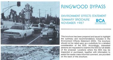 Ringwood and District Historical Society
Newsletter, Ringwood Bypass Environment Effects Statement Summary Brochure - November 1987
8-page A4 size brochure issued by Road Construction Authority reporting on the proposed Ringwood Bypass. Topics include Community Consultation, Estimated Capital Costs, Traffic Effects, Property Effects, Mullum Mullum Creek, Landscape Development, Pedestrian/Bicycle Access, Noise, Air Quality, Compatability with Ringwood District Centre Development, Vehicle & Traffic Aspects, Lighting, Construction Impacts, Extension to Canterbury Road, Public Transport.