Showing 297 items matching " the tree of life"
-
 Wodonga & District Historical Society Inc
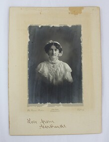
Photograph - Hamilton-Smith Collection Photograph of Gertrude Foord c. early 1900s, The Crown Studios: Vice-Regal Photographers
The Hamilton-Smith collection was donated by the children of Grace Mary Hamilton-Smith nee Ellwood (1911-2004) and John Hamilton-Smith (1909-1984) who settled in Wodonga in the 1940s. The Ellwood family had lived in north-east Victoria since the late 1800s. Grace’s mother, Rosina Ellwood nee Smale, was the first teacher at Baranduda in 1888, and a foundation member of the C.W.A. Rosina and her husband Mark retired to Wodonga in 1934. Grace and John married at St. David’s Church, Albury in 1941. John was a grazier, and actively involved in Agricultural Societies. The collection contains significant items which reflect the local history of Wodonga, including handmade needlework, books, photographs, a wedding dress, maps, and material relating to the world wars. This photograph is of Gertrude Foord (1885-1968), an aunt on the Hamilton-Smith family tree. Much of the needlework and textiles in the Hamilton-Smith collection belonged to Gertrude. This item has well documented provenance and a known owner. It forms part of a significant and representative historical collection which reflects the local history of Wodonga. It contributes to our understanding of social and family life in early twentieth century Wodonga, as well as providing interpretative capacity for themes including local history and social history.Black and white studio portrait photograph of a woman dressed in early 1900s dress, mounted on card.Handwritten inscription in bottom centre: "Love from/Gertrude". photograph, family photographs, photo, 1900s, edwardian, studio portrait, portrait -
 Wodonga & District Historical Society Inc
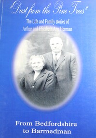
Book - Dust From the Pine Trees : The Life and Family Stories of Arthur and Elizabeth Ann Henman - From Bedfordshire to Barmedman, Lila McCann & Betty Lawrence
... . Dust From the Pine Trees : The Life and Family Stories ...The story of the life, family and achievements of Arthur Henman, born in 1861 in Lidlington, Bedfordshire, England and his wife Elizabeth Ann nee Pollard of Bonegilla, Victoria. For a time on arrival in Australia at the age of 17, Arthur had a contract to supply timber to the New South Wales Railway Department. After marrying in 1888, Arthur and Elizabeth became successful dairy farmers in Glen Innes, northern New South Wales, before deciding to come to the Barmedman district. They took up the property, now well known as "Pine Valley." They had a pioneer's task to face for a thick belt of green timber stretched from the back door of their first home to Temora. Undaunted by the task, but with great determination and courage, they fashioned a first class property out of the wild and waste of those days and made valuable contribution to the fledgling communities until retirement from active farming in 1923 when they moved to Sydney.non-fictionThe story of the life, family and achievements of Arthur Henman, born in 1861 in Lidlington, Bedfordshire, England and his wife Elizabeth Ann nee Pollard of Bonegilla, Victoria. For a time on arrival in Australia at the age of 17, Arthur had a contract to supply timber to the New South Wales Railway Department. After marrying in 1888, Arthur and Elizabeth became successful dairy farmers in Glen Innes, northern New South Wales, before deciding to come to the Barmedman district. They took up the property, now well known as "Pine Valley." They had a pioneer's task to face for a thick belt of green timber stretched from the back door of their first home to Temora. Undaunted by the task, but with great determination and courage, they fashioned a first class property out of the wild and waste of those days and made valuable contribution to the fledgling communities until retirement from active farming in 1923 when they moved to Sydney.pioneers australia, pioneers nsw, arthur henman, elizabeth ann pollard, barmedman district nsw -
 City of Kingston
Photograph - Colour, 30 July 2000
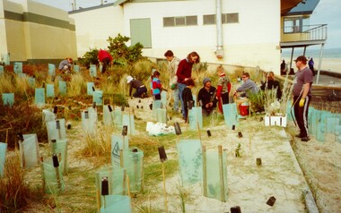
This photograph depicts workers/volunteers participating in tree planting on the foreshore as part of National Tree Day. It is uncertain which beach is it.Colour photograph of a gropu of people on a beach foreshore with a building (presumably surf life saving club) in the background. In front of the group are a many freshly planted trees surrounded by ground steaks and green plastic sheeting.Handwritten in black ink: National Tree Day / 30 July 2000 / Bon Beach? / Edithvale?ocean, trees, environment, volunteers -
 City of Kingston
Photograph - Black and white, Percy Fairlam, c. 1910
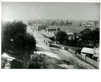
Black and white image of Cheltenham in the early 20th Century depicts an almost idyllic life. This photo was taken by Percy Fairlam, who climbed a tall pine tree to achieve the aerial view. The tree was a well recognised feature of the Cheltenham skyline but was cut down some time before World War II.Cheltenham was established as a rural market gardening community. The development of the railway was crucial to the ongoing development of the area. Community life sprung up around the railway line which is evident in the proximity of shopping and leisure.Black and white image depicting aerial view down Charman Road, Cheltenham, including the unsealed road, level crossing and shopping centre. What appears to be a cricket pitch is located behind the shops.Handwritten in black ink on a red round sticker adhered to the reverse, and then crossed out: X14 Handwritten in blue ink on reverse: A8 Handwritten in red ink on reverse: 85%cheltenham, railway crossing, roads, housing, shopping strip -
 Mrs Aeneas Gunn Memorial Library
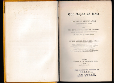
Book - The light of Asia, or, The great renunciation, Trubner and Co, Author, 1884
The Light of Asia, subtitled The Great Renunciation, weaves through its poetic verses the life and philosophy of Prince Siddhartha Gautama who attained enlightenment under the bodhi tree and became the Buddha. Receiving high acclaim since its publication in 1879, Edwin Arnold's work was adapted from the Lalitavistara Sutra (The Unfolding of the Play.) In the time before this work came out, little was known about Buddhism or the Buddha outside of Asia.p.238.non-fictionThe Light of Asia, subtitled The Great Renunciation, weaves through its poetic verses the life and philosophy of Prince Siddhartha Gautama who attained enlightenment under the bodhi tree and became the Buddha. Receiving high acclaim since its publication in 1879, Edwin Arnold's work was adapted from the Lalitavistara Sutra (The Unfolding of the Play.) In the time before this work came out, little was known about Buddhism or the Buddha outside of Asia.religion - buddhism, philosophy -
 Bendigo Historical Society Inc.
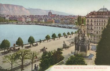
Postcard - ROY AND DORIS KELLY COLLECTION: GENEVE ET LE MONUMENT BRUNSWICK, CARTE POSTALE, 1900-1920
Postcard, coloured photo of Geneva, Switzerland on the shores of Lake Geneva. The Brunswick Monument is shown at right in the Jardin des Alpes. Several horse drawn carriages are parked among trees on the boulevard. The Monument is a mausoleum built in 1879, to commorate the life of Charles II, Duke of Brunswick. On the reverse is printed - Photographie- Verlag Wehrli A.-G. Kilchberg, Zurichpostcard, photograph, postcard, geneva, switzerland, duke of brunswick -
 Falls Creek Historical Society
Mixed media - Ross Milne Memorial Ski Jump
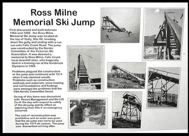
Ross Milne grew up on his family's tobacco property in Myrtleford, and began skiing at Falls Creek at an early age. He was taught by Austrian Sigi Haberzettl, who was chief coach at Falls Creek for 17 years. Ross went on to win the North-Eastern District Ski Association (NEDSA) Junior Championships for three consecutive years. In 1961 Ross was a member of the Australian team which competed against New Zealand in the Inter-Dominion Championships. In 1963, he won the Downhill and Alpine Combined title at the Australian Championships, while placing second in the Grand Slalom event. Ross was selected in the Australian team that participated in the 1964 Olympic Winter Games at Innsbruck, Austria. A few days before the opening of the Games, on 25th January 1964, he tragically lost his life when he crashed into a tree during a training run for the Men's Downhill. He was only 19 years of age. The construction of the Ross Milne Memorial Ski Jump was first discussed and built between 1964 and 1966. It was located at the top of Gully, Site 99, heading down the gully and ending with a run out onto Falls Creek Road. The Jump was constructed by the Nordic Committee of the Victorian Ski Association. Problems plagued the construction of the Jump and continued until 1974 when it was deemed unsafe. Problems such as construction methods and materials, snow loading and soil foundations and footings were some of the issues which the VSA Nordic Committee faced. On top of this there was discontent with Resort Management and the Lift Company of the day with respect to safety of the Ski Jump and its effect on adjoining chair lifts if an emergency should occur. The cost of reconstruction was prohibitive and an order was given that the SkiJump was not to be used during the 1974 ski season. The Jump was dismantled not long after.These items are significant as they document the development of a memorial to an Australian Olympic Skier, Ross Milne.A collection of documents and photographs documenting the construction of the Ross Milne Memorial Ski Jump built at Falls Creek in 1966. A display board including photographs and explanatory text is part of this collection.ross milne, ross milne memorial ski jump -
![Book - Novel, Vachell, Horace Annesley, Quinneys' [books I & II], 1914 (This reprint 1927)](/media/collectors/641920217f0478323d8a47a8/items/670ef005685dc78963bb40ed/item-media/6716cdf0ba05366ddbf7ec51/item-fit-380x285.jpg) Linton Mechanics Institute and Free Library Collection
Linton Mechanics Institute and Free Library CollectionBook - Novel, Vachell, Horace Annesley, Quinneys' [books I & II], 1914 (This reprint 1927)
Book centres around the life of Joseph Quinney, a London antique dealer. Explores Quinney's relationship with his family, his business rivalries, love, and romance.294 p. : pale blue cover embossed with pattern of leaves/treesfictionBook centres around the life of Joseph Quinney, a London antique dealer. Explores Quinney's relationship with his family, his business rivalries, love, and romance. fiction, antique dealers, horace annesley vachell -
 Eltham District Historical Society Inc
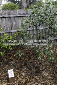
Photograph, Peter Pidgeon, Dedication of a Golden Wattle in memory of Harry Gilham and Sue Law, Local History Centre, 728 Main Road, Eltham, 12 April 2024
A Golden Wattle tree was planted in memory of Eltham District Historical Society life members Harry Gilham (24 Mar 1928-25 Feb 2024; EDHS President 1993-2009) and Sue Law (27 Sep 1937-8 Aug 2023; EDHS President 1985-1993, Vice President 1993-1998 & 2009-2015). Close members of Harry’s and Sue’s families along with EDHS Committee members and life member Doug Orford joined in a dedication ceremony to commemorate their contributions, on Friday 12 April at 10.00am, in the rear yard at the Local History Centre, 728 Main Road, Eltham, on the corner of Brougham Street. EDHS President Jim Connor welcomed family members and acknowledged the dedicated efforts of both Harry and Sue over a long period of years. After unveiling of the plaque, attendees enjoyed some morning tea and sharing stories of Harry and Sue.Born Digital (15 images)activities, eltham district historical society, local history centre, main road, eltham, alison delaney, dedication, doug orford, gilham family, golden wattle, harry gilham, irene kearsey, jim connor, joan castledine, law family, peter & elizabeth pidgeon collection, plaques, richard pinn, robert marshall, russell yeoman, sue dyet, sue law -
 Eltham District Historical Society Inc
Photograph - Digital Photograph, Alan King, Edendale Farm Homestead, 29 January 2008
Edendale Farm is Nillumbik Shire Council's environment centre situated in Gastons Road, Eltham between the railway and the Diamond Creek. The homestead on the property was built in 1896 and is of historical significance, being the subject of a Heritage Overlay under the Nillumbik Planning Scheme. The Edendale property was originally part of an extensive land purchase in 1852 from the Crown by pioneer Eltham farmer Henry Stooke. He initially purchased 51 acres and later expanded his holdings by purchasing another three adjacent Crown allotments extending northerly from Josiah Holloway's Little Eltham subdivision. Despite clearing the land, Stooke did not build on this property, choosing to live on his property "Rosehill" at Lower Plenty. In 1896 Thomas Cool, Club Manager of the Victoria Coffee Palace in Melbourne purchased 7 acres of the original Stooke land and built the house now known as Edendale. Cool did not farm the land, instead using it as a gentleman’s residence, retiring to Eltham at weekends. In 1918 he purchased an additional 7 acres but in 1919 he sold the property. Later owners included J.W. Cox, the Gaston family and D. Mummery. In the 1980s the Eltham Shire Council purchased the site for use as a Council depot, but this use did not proceed. Subsequently, it was used as the Council pound. The Edendale Farm Pet Education and Retention Centre was established in the summer of 1988/1989 and was set up to replace the existing dog kennels with a high standard pet retention centre. The design style of the building was established to compliment the features of the existing house. It was equipped with 10 retention pens, a veterinary room and a pet education area where school children and other interested parties learnt about pet care procedures. It was later developed into a community farm and was run by an advisory committee and in 2000 it became an Environment Centre. In early 2006 an advisory committee was established for the development of a master plan for future development at Edendale Farm. The committee included Russell Yeoman, a former long-time shire planner and founding member of the Eltham District Historical Society. At the time of filming the Master Plan and future for Edendale was about continuing to develop Edendale as a centre of environment learning and looking at expanding displays and school program, running a lot more of life-long learning and workshops around sustainable living. Covered under Heritage Overlay, Nillumbik Planning Scheme. Published: Nillumbik Now and Then / Marguerite Marshall 2008; photographs Alan King with Marguerite Marshall.; p101 A sharp turn from busy Wattletree Road by the railway line, brings a surprise. Only 1.4 km from Eltham’s centre, sheep feed, blissfully unaware of the hectic suburban activity so close by. At the entrance to the 5.6ha Edendale Farm is another surprise. A work of art that looks like huge tree trunks transformed into bowler and top-hatted men. The Fences Act 1968 by Tony Trembath with Mark Cain and John Doyle, 1996, is classified by the National Trust of Australia as having Regional Significance. The title refers to a government act on disputes between neighbors over the placement of fences and boundaries. This takes a ‘wry swipe’ at a community divided by trivial squabbles. It also celebrates making do with limited resources.1 Further along on the left, the office wall is decorated with a massive Eltham Copper Butterfly, designed by Robert Tickner and made by school children with used plastic bottles and other waste material. Nillumbik Council runs Edendale as an Environmental Education Centre, to help preserve and enhance the local environment. As early as 1988 the former Eltham Shire Council realised Edendale’s importance in meeting people’s needs, particularly of children, to enjoy farmland. The centre, with the Eltham North Reserve to the north - including remnant bushland and open parkland - makes up the major part of the public open space for this area. The council considers this area will become increasingly important to the local community for recreational use.2 Educational programs aim to encourage community involvement to ensure the long-term rehabilitation and protection of natural bushland areas. Edendale is used by people of all ages - from school children to adults - for environmental programs and workshops, as well as for recreation, to enjoy the domestic animals and to picnic. Edendale is also home to the Environmental Works staff who manage reserves and roadsides and support Nillumbik Friends environmental groups. The Friends propagate plants at the nursery, which grows indigenous plants and sells these to the public.3 The centre demonstrates the sustainable living the farm teaches, with features like solar hot water and drive lighting and for the fireplace, logs of recycled cardboard. Edendale has had a varied history as a dog pound and even as a retreat for Thomas Cool, Club Manager of the Victoria Coffee Palace in Melbourne. His single-storey weatherboard house built in 1896, which still stands, was grander than most homes in Eltham. Although such buildings were common in many other parts of Melbourne, Eltham’s poverty and remoteness did not encourage such construction. The Victorian rectangular-shaped house, with a corrugated iron roof and veranda, has elegant large rooms, leadlight windows, ceiling roses, two bay windows and ornately carved wooden fireplace surrounds. Cool bought seven acres (2.8ha) from pioneer Eltham farmer Henry Stooke’s 200 acre (81ha) farm, which he had bought from the Crown in 1852. In 1918 Cool bought an extra seven acres (2.8ha) but in 1919 sold the estate to farmer John Cox. In 1933 Cox sold Edendale to Mrs Elizabeth Gaston, after whom the road leading to the centre was named. The property was owned by several Gaston family members, who called it Edendale, then by a police constable, Douglas Mummery, until the Shire of Eltham bought it in 1970. Oddly Edendale was known as Mummery’s for almost 20 years, although Mummery owned it only for a short time.4 The shire used Edendale as a dog pound until amalgamation with other municipalities in 1996. The pound then moved to the Yan Yean Road, Plenty site, which had been used by the former Diamond Valley Shire Council. To the west and north the centre is bounded by Diamond Creek and on the east by the Melbourne-Hurstbridge railway line. Part of the Research creek forms the centre’s southern boundary.This collection of almost 130 photos about places and people within the Shire of Nillumbik, an urban and rural municipality in Melbourne's north, contributes to an understanding of the history of the Shire. Published in 2008 immediately prior to the Black Saturday bushfires of February 7, 2009, it documents sites that were impacted, and in some cases destroyed by the fires. It includes photographs taken especially for the publication, creating a unique time capsule representing the Shire in the early 21st century. It remains the most recent comprehenesive publication devoted to the Shire's history connecting local residents to the past. nillumbik now and then (marshall-king) collection, edendale farm -
 Eltham District Historical Society Inc
Photograph - Digital Photograph, Alan King, Eltham Living and Learning Centre, 26 January 2008
In 1857, tanner John Pearson purchased three and a half acres of land in Little Eltham, at the western end of Pitt Street, with a 70-foot frontage to Maria Street (Main Road) and stretching down to the Diamond Creek for £100. He contracted Benjamin Oliver Wallis to build house for him. Wallis, a mason by trade who originated from the Cornish village of Newlyn, migrated to Melbourne in 1853 and was shortly engaged by Richard Warren to build the Eltham Hotel, which opened in 1854. When Warren fell into financial difficulty in 1858, Wallis purchased the hotel. That same year, Pearson constructed a tannery below the house with access to the water in the Diamond Creek. When Pearson became bankrupt in 1867, Wallis similarly acquired the house from Pearson’s creditors in 1868 and lived there until his death in 1896. For some of this time the house was in the name of Wallis’s son Richard but following his death in 1888, ownership reverted to his father. It was purchased by retired teacher Richard Gilsenen in 1899. Gilsenen was made acting head teacher at the Eltham State School in 1906 following the sudden death of head teacher John Brown. In the 1950s the house was bought by retired engineer Dr Alfred Fitzpatrick and his wife Claire who made various modifications to house goats and poultry as well as structural modifications to the house. In the early 1970s, Eltham Shire Councillors Frank Maas and Don Maling proposed an extended communities’ activities program be set up and the Commonwealth Grants Commission was approached for financial assistance. In 1974 a $50,000 Commonwealth Grant was received by the Shire Council to acquire the Fitzpatrick property as part of the planning to establish an extended communities’ activities program. The Fitzpatricks moved next door and Claire taught at the new Living and Learning Centre, which began in 1975, one of the first community education centres in Victoria. Covered under Heritage Overlay, Nillumbik Planning Scheme. Published: Nillumbik Now and Then / Marguerite Marshall 2008; photographs Alan King with Marguerite Marshall.; p59 It’s a centre for sharing knowledge and friendship and it stands on the former hub of Eltham’s original township near Pitt Street. The Eltham Living and Learning Centre, with around 2000 participants a year, began in 1975 as one of the first Community Education Centres in Victoria. Classes ranging from macramé to wine making to environmental living have enriched the lives of thousands of people through the generosity of tutors sharing their skills free of charge. The centre’s heart is the brick cottage, built in 1858 by tanner John Pearson. He bought the three and a half acre (1.4ha) allotment fronting Maria Street (now Main Road) and stretching down to the Diamond Creek. The allotment formed part of a 316 acre (127.8ha) subdivision, owned by Josiah Holloway, called Little Eltham, north of the original Eltham Reserve.1 The allotment then passed through the hands of several speculators before it was sold to Pearson for £100 in 1857. Mr Pearson’s children attended the Eltham Primary School from 1864 to 1867. But creditors took possession of the property when his tannery folded in 1867. It was then sold to publican Benjamin Wallis, who owned the Eltham Hotel at the corner of Pitt Street and Main Road. In 1899 the property was bought by Richard Gilsenan, who became acting head teacher of the Eltham Primary State School in 1906. In the 1950s, retired engineer Dr Alfred Fitzpatrick and his wife Claire bought the property, and made structural changes. Claire, a journalist and community campaigner, modified and built pens for goats and poultry, a stable, a garage and planted fruit trees and a vegetable garden. In the early 1970s a young woman called Carina Hack approached Gwen Wesson at the Diamond Valley Learning Centre (Victoria’s first Community Education Centre) about starting a community centre. Following Wesson’s suggestion, Hack spoke to Shire President Alistair Knox ‘one bleak rainy afternoon, sipping hot drinks and discussing life’.2 Eltham Shire Councillors Frank Maas and Don Maling proposed a community activities program and the council received a $50,000 Commonwealth Government Grant for this venture.3 The Fitzpatricks sold their property to the council and moved next door and Claire taught at the new centre, which Hack named. Eltham obviously wanted such a centre as Hack recalls. ‘During the next two months we had about 50 volunteers working day, night and weekends, scrubbing down, plastering and painting walls, replacing floors, repairing fences, recycling furniture, sewing curtains and cushions, donating furniture, toys, equipment, clean-ing and gardening…’4 The first enrolment day saw a queue stretching up the driveway nearly to the gate and the first sessions attracted 270 people a week. Soon the outbuildings were converted into pottery studios and a large workshop. From 1979 the Eltham Art and Craft Market was held in the centre’s grounds and the Friends of the Centre ran it from 1980. A former program coordinator, Margaret Johnson, remembers enrolment day in the late 1970s and 1980s, when hundreds of people would queue – and some even camped overnight! Overnighters were greeted in the morning with fresh tea and toast. Another tradition was The Enrolment Day Cake with Recipe, given to volunteers. ‘One happy Enrolment Day fell on February 14 and let’s just say that St Valentine found some willing participants, paying $2 for a kiss.’5 Meanwhile the participants’ children could play at the Council Eltham Lower Park house in Hohnes Road, later in Susan Street. But the centre has had difficulties too. In 1990 a fire destroyed the stable and the police suspected arson. However the pavilion was built in its place.This collection of almost 130 photos about places and people within the Shire of Nillumbik, an urban and rural municipality in Melbourne's north, contributes to an understanding of the history of the Shire. Published in 2008 immediately prior to the Black Saturday bushfires of February 7, 2009, it documents sites that were impacted, and in some cases destroyed by the fires. It includes photographs taken especially for the publication, creating a unique time capsule representing the Shire in the early 21st century. It remains the most recent comprehenesive publication devoted to the Shire's history connecting local residents to the past. nillumbik now and then (marshall-king) collection, benjamin oliver wallis, claire fitzpatrick, don maling, dr alfred fitzpatrick, eltham living and learning centre, frank maas, john pearson, richard gilsenen, tannery -
 Eltham District Historical Society Inc
Photograph - Digital Photograph, Alan King, St Andrews Hotel, 2 February 2008
The c1860 St Andrews Hotel, with the c1930 additions, and the Canary Island Palm, and the surrounding site to the title boundaries are historically, socially and aesthetically significant to the Shire of Nillumbik. The St Andrews Hotel is historically significant because it may have given its name 'St Andrews' to the town (another suggestion is that the name came from St Andrews church) and for its connection to Ewen Hugh Cameron (1831-1915) the prosperous local farmer, member of the Eltham Roads Board/Shire Council and local MP. It is also significant as the oldest hotel building in the former Shire of Eltham, as one of the few surviving buildings connected with the Caledonian goldfields era and as one of a handful of early structures to have survived the 1960s bushfires; the additions and alterations to the hotel reflect its long life. The hotel is socially significant because it has served as an important meeting place for more than 160 years. The Canary Island Palm is historically significant as a rare example of exotic tree planting in this rural area. The tree is aesthetically and historically significant as a local landmark and for its contribution to the streetscape and landscape value. Covered under Heritage Overlay, Nillumbik Planning Scheme. Published: Nillumbik Now and Then / Marguerite Marshall 2008; photographs Alan King with Marguerite Marshall.; p71 Built around 1860, St Andrews Hotel has changed little since it first welcomed thirsty gold diggers from the Caledonia Goldfields. The timber building, with gabled roof, beamed ceilings and a massive fireplace, is Nillumbik Shire’s oldest hotel and has always been an important community centre, particularly in its early days. Fortunately, the hotel and the near-by Canary Island Palm Tree, which is quite rare in this area, survived the 1960s bushfires, along with a few other early buildings. St Andrews (formerly Queenstown) was founded on gold, as were Panton Hill (formerly Kingstown), Research and Diamond Creek, from the mid-1850s to the 1860s. But by the early 20th century common use changed the name Queenstown to St Andrews, possibly after this hotel or after the church or the mining district.1 The Caledonia Diggings were probably named by Scottish settlers after the Roman name for Scotland, despite this land bearing little similarity to their homeland.2 Queenstown, which was proclaimed as a township in 1861, was the gold-mining centre on the Upper Diamond and in the 1850s had up to 600 European inhabitants and a small camp of Chinese on the flats along the creek. Queenstown was the administrative centre of the Upper Diamond with three hotels, a brewery and a slaughterhouse.3 It is unclear which hotel was the district’s first, as distinct from the earliest unlicensed grog shops, some of which operated in tents. John Corke Knell was one of eight unlicensed storekeepers supplying drink to miners at Caledonia in 1857, named by Sgt. McNamara of the Caledonia Police Station.4 In February 1859, Knell apparently bought most of the present hotel’s site at the first township land sales. As he was a local storekeeper, he might have first established a store there.5 Knell and his wife Eliza were early licensees of the St Andrews Hotel. The hotel had eight bedrooms – including three for public use – and the dining-room seated 30 people. It is thought they named the hotel St Andrews after Eliza’s hometown of St Andrews in Scotland. St Andrews Hotel was an important local centre in several ways. In the same building the Knells also operated a post office and general store. In 1867 Mrs Knell was appointed Deputy Registrar of Births and Deaths for Queenstown. The hotel was also used to hold inquests into people’s deaths when the police residence became too small.6 The hotel also became a fashionable destination at Christmas for parties from Melbourne. In 1868, possibly following her husband’s death, Mrs Knell applied for a temporary licence, which was then transferred to Robert Smith after their marriage in 1869. But then, possibly after Robert’s death, Mrs Smith operated the hotel until 1892. This contradicts a report in The Evelyn Observer 1882 that JC Knells of the St Andrews Hotel was granted a publican’s licence in the Queenstown Police Court. At that time he was supposed to have been dead for around 14 years! Although Mrs Smith was a respected citizen, known for her geniality and as an ideal hostess, she had a minor brush with the law when she was fined ten shillings for not lighting a lamp outside her licensed premises.7 From 1892 several publicans owned the hotel including W Atkins, from 1895. In 1909 the licensee was apparently Mrs Smith’s son, Walter Knell, who held the licence until at least the 1920s. Not surprisingly, this old hotel has attracted romantic stories. Mrs Smith is said to be seen roaming the pub in her nightdress – even though she was buried in the Queenstown Cemetery in 1911.8 A musical The Hero of Queenstown, set in the hotel, was written and produced by local actor Reg Evans in the 1970s.This collection of almost 130 photos about places and people within the Shire of Nillumbik, an urban and rural municipality in Melbourne's north, contributes to an understanding of the history of the Shire. Published in 2008 immediately prior to the Black Saturday bushfires of February 7, 2009, it documents sites that were impacted, and in some cases destroyed by the fires. It includes photographs taken especially for the publication, creating a unique time capsule representing the Shire in the early 21st century. It remains the most recent comprehenesive publication devoted to the Shire's history connecting local residents to the past. nillumbik now and then (marshall-king) collection, st andrews hotel -
 Eltham District Historical Society Inc
Photograph - Digital Photograph, Alan King, Kinglake National Park, 27 March 2008
Fern gullies around Jehosaphat Gully Covered under National Estate. Published: Nillumbik Now and Then / Marguerite Marshall 2008; photographs Alan King with Marguerite Marshall.; p125 The magnificent Kinglake National Park, fringing Nillumbik’s north, is the largest national park close to Melbourne. Thanks to the vision and hard work of a band of local people, the park was created from what was rapidly becoming degraded land. Seeing a threat to Kinglake’s indigenous flora and fauna, several prominent local people campaigned for a national park, which was established in 1928.1 Since then, the park has grown through donations and acquisitions of land, from around 13,800 acres of land (5585ha) to 22,360 hectares. The Sugarloaf and Everard Blocks – of almost 8000 hectares – stand in Nillumbik and the park extends into Mitchell and Murrundindi Shires and the City of Whittlesea. Mt Everard commemorates William Hugh Everard, State member for Evelyn when the park was established. Before 1928, European settlers had degraded the Kinglake area, which was named after the celebrated English author and lawyer, Alexander William Kinglake. Remains of gold shafts and diggings in the park are reminders of Kinglake’s first settlers, who hoped to strike it rich at the gold diggings. But like other gold fields in this shire, they proved not very lucrative and soon timber cutting replaced mining in importance. However, before long, the accessible timber supply ran out, so in the 1920s agriculture took over – particularly potatoes and berry fruits – which involved large-scale clearing.2 The park’s instigator was retired Melbourne University Professor of Music, William Laver.3 As chair of the Kinglake Progress Association he began negotiations to have crown lands on the southern scarp of the Great Dividing Range reserved as a national park. Even before the park was proclaimed, from 1927, KPA members cut tracks to the major scenic points. Professor Laver was one of several people who gave land for the park, donating around 50 acres (20ha), including the Jehosaphat Gully.4 Laver chaired the park’s first Committee of Management, which raised money to employ a ranger and provide facilities, including tracks and roads for fire protection vehicles, toilets and shelters. The committee charged fees for firewood collection, some grazing of livestock, and visitor entrance, and obtained small State Government and Eltham Shire grants. In 1957 the State Government provided revenue for national parks. Then, in 1975, the State Government took over the management and the Committee of Management became an advisory committee, which disbanded in 1978. Originally, the park covered crown land in the Shires of Eltham and Whittlesea; then Wombelano Falls in Yea and other areas were added. In 1970 the park extended into the Shires of Eltham, Healesville, Whittlesea and Yea.5 Bush fires have been an ongoing problem. In 1939 hundreds of eucalypts and acacias had to be sown around the Jehosaphat Gully to rejuvenate the forest. To manage bushfires, the Committee of Management, then the State Government, worked closely with the Forestry Commission, shire councils and local fire brigades. Early national parks focussed on recreation. But by the 1980s, conservation, education and scientific research became more important, playing a vital role in preserving representative samples of the natural environment. Each year many thousands of people use the park’s extensive network of walking tracks amongst the protected plant and animal life as well as camping, cycling and horse riding. The park, along the slopes of the Great Dividing Range, has lookouts revealing magnificent views of the Melbourne skyline, Port Phillip Bay, the Yarra Valley and the You Yangs. Vegetation in the Masons Falls area includes messmate forest, Austral grass-trees, ferns and Hazel Pomaderris. In spring, orchids, lilies, everlasting daisies, correas, grevillea and heath appear. Around Jehosaphat Gully are wet and dry forest, fern gullies and banksia. Animal life includes wallabies, kangaroos, koalas, echidnas, possums, gliders and bandicoots. Male lyrebirds can be heard mimicking in the Jehosaphat Gully, particularly in the Everard Block in winter.This collection of almost 130 photos about places and people within the Shire of Nillumbik, an urban and rural municipality in Melbourne's north, contributes to an understanding of the history of the Shire. Published in 2008 immediately prior to the Black Saturday bushfires of February 7, 2009, it documents sites that were impacted, and in some cases destroyed by the fires. It includes photographs taken especially for the publication, creating a unique time capsule representing the Shire in the early 21st century. It remains the most recent comprehenesive publication devoted to the Shire's history connecting local residents to the past. nillumbik now and then (marshall-king) collection, kinglake national park, jehosaphat gully -
 Bialik College
Mixed media (Item) - 2006 Bialik various images
... ELC Sukkot Rock Schools Hooptime JNF Tree Planting Athletics ...Photographs taken during Bialik College year of 2006. Includes photographs about Early Learning Centre, sport, classroom and religious events. Please contact [email protected] to request access to this record.2000s, 2006, bnei, corp break, chabad, elc, sukkot, rock schools, hooptime, jnf tree planting, athletics, jewish life -
Federation University Historical Collection
Magazine - Booklet, Ballarat School of Mines Students' Magazine, 1943, 1943
List of Full Course Students' 1943, Editorial, News, Obituary, News and Notes, The Literary Society, Fumes from the Lab, Arts & Crafts Gossip, Sport, Commercial Notes, The Junior Techs Black, green and gold soft covered magazine of 62 pages including advertisements. Artworks Mr Ferguson - By Beryl Grinter Miss Will - By Beryl Grinter Mr Tern - By Ruth Mole Editor - By Margaret Dark Digger - By Joan Walter Kangaroos - By Margaret Dark Lake Wendouree (Fairyland) - By Marion Beckwith Trees at Lake Wendouree - By John Lannen SMB - So much better - By Max Coward Miss Grigg - By Joan Walter Margaret By Joy Martin Head Study from Life - By Ruth Mole Joan - By Margaret Dark Study from Nature - By Beryl Grinter Muriel - By Ruth Mole Carrol - By Ruth Mole Murrell - By Beryl Grinter Betty - By Ruth Mole Kath - By Ruth Mole Pat - By Margaret Dark Betty - By Joan Walter Dorothy - By Joan Walter Margaret - By Margaret Dark Jeanie - By Joan Walter Lois - By Margaret Dark Peanut - By Beryl Grinter Curly - By Ruth Mole Joan - By Patricia Allan Alison - By Ruth Mole June - By Ruth Mole Ice Cream - By Margaret Dark Wright - By Beryl Grinter Willian - By Margaret Dark Duke - By Margaret Dark Redfern - By Beryl Grinter Tilgner - By Beryl Grinter Walla - By Joan Walter Fumbrey - By Joan Walter Coad - By Margaret Dark Fletcher - By Ruth Mole Legs - By Joan Walter Signed on front cover by "H. Yates".ballarat school of mines, magazine, alan w. wilson, wallace whiteside, jean ballinger, john r. elliott, bill f. carroll, maxwell richards, margaret dark, maxwell lawrence, l. strick, marion beckwith, geoffrey biddington, frances duffy, ian d. mclachlan, joy martin, ian cooper, valma falla, percival d. fisher, alma reid, f. day, n. pierce, john procter, dr pound, mr mein, a. mckenzie,, ruth mole, beryl grinter, h. b. murphy, margaret c. young, w. c. watts, john brittain, winsome hender, shirley dolan, adeline helm, j. f. lannen, max coward, alan e. daff, b. scott, lloyd o. lehmann, ernest j. poppins, b. egelton, john h. prout, roy e. mawby, robert j. mckenzie, phillip p. coulson, j. lawry, james owen, john w. jolly, norman k. clark, barbara curwen-walker, beryl hawkins, betty d. willian, beryl bedford, glenis dow, betty law, norma eltringham, jean lewis, dorothy ritchie, gwenda harrison, eileen dawkins, margaret lenaghan, olga m. lawrence, miss king, mrs mcilvena, h. packham, b. refurn, s. lang, d. hart, e. adams, f. savage, p. humphrey, e. skilbeck, a. carland, b. doull, r. ingleton, f. reeve, k. gowan, b. holloway, f. smith, t. bennett, mr bergin, s. wallis, d. struthberry, k. saunders, john lannen, patricia allan, joan walter -
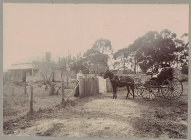 Linton and District Historical Society Inc
Photograph, Conversation at the Front Fence, undated
Black and white image mounted on light grey card. Image shows a weatherboard house in background, trees and a boundary fence. Two women are standing at the fence. Other side of the fence is a horse drawn cart with a man and a young female seated there.rural life, horses, horse drawn vehicles, houses -
 Stawell Historical Society Inc
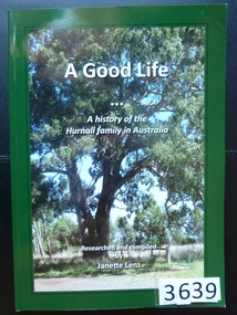
Book, Janette Lenz, A Good Life, A History of the Hurnall Family in Australia - Previously Cat No 3639, 2011
... with a colour Photograph of a magnificent Gum Tree A Good Life ...A History of the Hurnall family in AustraliaGreen card Cover with a colour Photograph of a magnificent Gum TreeA Good Life A History of the Hurnall family in Australia researched and compiled by Jeanette Lenzstawell, family history -
Marysville & District Historical Society
Document (item) - Research Document, Judith Vimpani, Hermit of the Cumberland Goldfield-George Ernest Locke, 2020
An account of the life of George Ernest Locke who was a gold miner on the Yarra Track near Marysville in Victoria.An account of the life of George Ernest Locke who was a gold miner on the Yarra Track near Marysville in Victoria. George was a well-educated young man and had some success prospecting in the Cumberland area before partnering with William Chester with whom he opened the Golden Bower gold mine in 1896. George and William then discovered a second reef which they named the Silver Bower mine. George lived in a log cabin in the Cumberland reserve and was known to be a loner. He was clever with his money and chose not to have a bank account in Marysville, where everyone would learn about his financial status. He banked at the ES&A in Fitzroy and at the time of his death in 1941 he had accumulated the princely sum of three hundred and sixty pounds. George Locke was known as "the Hermit of Cumberland Valley" and lived in his humpy until his last few days during which he moved into a Forest Commission's patrol hut because his old humpy had started to fall to pieces. When George passed away at the age of 81 years he had not visited Marysville for over 14 years. george ernest locke, gold miner, gold mining, yarra track, william chester, golden bower mine, cumberland goldfield, silver bower mine, chesterville, marysville, victoria, jackie lewis, baron somers, big tree, picea sitchensis exotic, box hill cemetery, john edward locke, annie caroline locke, hermit of the cumberland valley -
 Bendigo Historical Society Inc.
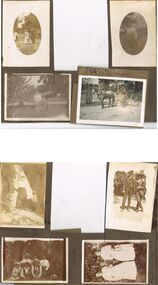
Photograph - HILDA HILL COLLECTION: BLACK AND WHITE PHOTOS, 1917-1922
Series of Black & White Photos Total 8 Hill Family & Friends during the final years of World War I and into the touring boom of the 1920s. Lady dressed in all white, with dark coloured scarf over her shoulder, parasol in her right hand, in conversation with The Dean January 28th 1918.Oval photo of young girl dressed in dark skirt and white blouse in bush setting with trees in background, photo not very clear, 'Durvol' Kyneton 1918. Mollie & Babe Railway Reserve Kyneton, girl in light coloured dress reclining on the ground, other girl in kneeling position wears dark skirt and white blouse, palm tree to the left background, further back is paling fence, shrubbery to the right background, 1918. Horse & 4 wheeled Gig, man seated wears a dark suit with white shirt and dark tie, horse appears to be a grey colour, background shows bull nose veranda roof and part of a house gable, tree in framework on nature strip. Nell wearing a dark skirt and white top, right hand touching a shrub, white structure in the background, 'The Ranch' Eppalock November 1918. Botanical Gardens group photo, six young ladies, one wearing a vertical striped dress, three wear dark dresses with white blouses, two wear white blouses and dark skirts, one black hat and three light coloured, light hat in right foreground, January 1919. Jack & Mick in dark suits, white shirts, striped ties, shrubbery in the background, long trousers 'The Ranch' Eppalock January 14th 1917. two young ladies in all white, one holding a hat, young boy in dark clothing white shirt and dark tie, holding long stick, large shrub in the background, 'The Pines' Kyneton January 1919.Hilda Hill Personal Collectionaustralia, history, post war life -
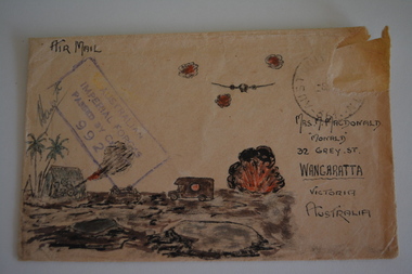
 Wangaratta RSL Sub Branch
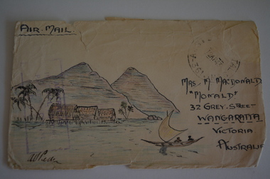
Work on paper - Envelope Art
Sent to Mrs McDonald "Monald" 32 Grey Street Wangaratta from soldier during second world warVictoria's 2/24th Infantry Battalion was raised in Wangaratta in July 1940. They were welcomed with open arms by the local community as they rapidly built up their numbers. The people of Wangaratta adopted the Battalion and they became known as "Wangaratta's Own" because of the time the battalion spent in the town during its formative period prior to deployment overseas. Many of the soldiers maintained life long friendships with the people of Wangaratta. Even though the Battation was disbanded in 1946 members and their families return each year, in November, for a commemorative service at the 2/24th Battalion Memorial Wall at the Wangaratta Cemetery.Cream paper envelope with coloured drawing of small boat and three huts on stilts in water with palm trees and two mountains in background.Top left - AIR MAIL Top right - postage stamp Right side Mrs M acDonald "Monald" 32 Grey Street Wangaratta Victoria Australiaww2, envelope art -
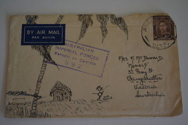 Wangaratta RSL Sub Branch
Work on paper - Envelope Art
Sent to Mrs McDonald "Monald" 32 Grey Street Wangaratta from a soldier during second world warVictoria's 2/24th Infantry Battalion was raised in Wangaratta in July 1940. They were welcomed with open arms by the local community as they rapidly built up their numbers. The people of Wangaratta adopted the Battalion and they became known as "Wangaratta's Own" because of the time the battalion spent in the town during its formative period prior to deployment overseas. Many of the soldiers maintained life long friendships with the people of Wangaratta. Even though the Battation was disbanded in 1946 members and their families return each year, in November, for a commemorative service at the 2/24th Battalion Memorial Wall at the Wangaratta Cemetery.Cream paper envelope with hand drawing of palm tree and thatched hut with stick figure in centre.Top left - AIR MAIL Top right - postage stamp Middle - AIF Censor stamp Right side Mrs M McDonald "Monald" 32 Grey Street Wangaratta Victoria Australiaww2, envelope art -
 Eltham District Historical Society Inc
Photograph - Digital Photograph, Alan King, Blue Lake, Plenty Gorge Park, 2008
A quarry was transformed into the Blue Lake. Published: Nillumbik Now and Then / Marguerite Marshall 2008; photographs Alan King with Marguerite Marshall.; p179 The dramatic steep-sided Plenty Gorge lies along the divide of two geological areas, and separates the Nillumbik Shire and the City of Whittlesea. On the Nillumbik side are undulating hills and sedimentary rock, and in Whittlesea, lies a basalt plain formed by volcanic action up to two million years ago. This provides the Plenty Gorge Park with diverse vegetation and habitats, making it one of Greater Melbourne’s most important refuges for threatened and significant species. The park, established in 1986, consists of around 1350 hectares, and extends 11 kilometres along the Plenty River, from Greensborough to Mernda. It provides a wildlife corridor for around 500 native plant and 280 animal species. The area’s plentiful food and water attracted the Wurundjeri Aboriginal people and then European settlers. By 1837 squatters had claimed large runs of land for their sheep and cattle. The Plenty Valley was among the first in the Port Phillip District to be settled - mainly in the less heavily timbered west - and was proclaimed a settled district in 1841.But by the late 1880s, the settlers’ extensive land clearing for animal grazing, then agriculture, depleted the Wurundjeri’s traditional food sources, which helped to drive them away. Many Wurundjeri artefacts remain (now government protected), and so far 57 sites have been identified in the park, including scarred trees, burial areas and stone artefacts. Pioneer life could be very hard because of isolation, flooding, bushfires and bushrangers. Following the Black Thursday bushfires of 1851, basalt was quarried to build more fire-resistant homes. Gold discoveries in the early 1850s swelled the population, particularly around Smugglers Gully; but food production made more of an impact. In the late 1850s wheat production supplanted grazing. In the 1860s the government made small holdings available to poorer settlers. These had the greatest effect on the district, particularly in Doreen and Yarrambat, where orchards were established from the 1880s to 1914. Links with a prominent early family are the remains of Stuchbery Farm, by the river’s edge bounded by Smugglers Gully to the north and La Trobe Road, Yarrambat, to the east. The Stuchberys moved to the valley in 1890, and the family still lives in the area. In 1890, Alfred and Ada first lived in a tent where four children were born, then Alfred built the house and outbuildings around 1896. They planted an orchard, then a market garden, and developed a dairy. The family belonged to the local Methodist and tennis communities. Their grandson Walter, opened the Flying Scotsman Model Railway Museum in Yarrambat, which his widow, Vi, continues to run. Wal was also the Yarrambat CFA Captain for 22 years until 1987. Walter sold 24 hectares in 1976 for development - now Vista Court - and in 1990, the remaining 22.6 hectares for the park. Remaining are an early stone dairy and remnants of a stone barn, a pig sty and a well. Until it was destroyed by fire in 2003, a slab hut stood on the Happy Hollow Farm site, at the southern end of the park. The hut is thought to have been built in the Depression around 1893. This was a rare and late example of a slab hut with a domestic orchard close to Melbourne. Emmet Watmough and his family first occupied the hut, followed by a succession of families, until the Bell family bought it around 1948. There they led a subsistence lifestyle for 50 years, despite encroaching Melbourne suburbia. The Yellow Gum Recreation Area includes the Blue Lake, coloured turquoise at certain times of the year. Following the 1957 bushfires, this area was quarried by Reid Quarries Pty Ltd for Melbourne’s first skyscrapers, then by Boral Australia. However in the early 1970s water began seeping into the quarry forming the Blue Lake and the quarry was closed. The State Government bought the site in 1997 and opened it as a park in 1999.This collection of almost 130 photos about places and people within the Shire of Nillumbik, an urban and rural municipality in Melbourne's north, contributes to an understanding of the history of the Shire. Published in 2008 immediately prior to the Black Saturday bushfires of February 7, 2009, it documents sites that were impacted, and in some cases destroyed by the fires. It includes photographs taken especially for the publication, creating a unique time capsule representing the Shire in the early 21st century. It remains the most recent comprehenesive publication devoted to the Shire's history connecting local residents to the past. nillumbik now and then (marshall-king) collection, blue lake, plenty gorge park -
 Eltham District Historical Society Inc
Photograph - Digital Photograph, Marguerite Marshall, Stuchbery Farm dairy, 14 March 2008
Stuchbery Farm was situated on the Plenty River bounded by Smugglers Gully to the north and La trobe Road, Yarrambat, to the east. Alan and Ada Stutchbery moved to the valley in 1890, first living in a tent where four children were born. Alfred built a home and outbuildings around 1896. They planted an orchard, then a market garden and developed a dairy. Published: Nillumbik Now and Then / Marguerite Marshall 2008; photographs Alan King with Marguerite Marshall.; p179 The dramatic steep-sided Plenty Gorge lies along the divide of two geological areas, and separates the Nillumbik Shire and the City of Whittlesea. On the Nillumbik side are undulating hills and sedimentary rock, and in Whittlesea, lies a basalt plain formed by volcanic action up to two million years ago. This provides the Plenty Gorge Park with diverse vegetation and habitats, making it one of Greater Melbourne’s most important refuges for threatened and significant species. The park, established in 1986, consists of around 1350 hectares, and extends 11 kilometres along the Plenty River, from Greensborough to Mernda. It provides a wildlife corridor for around 500 native plant and 280 animal species. The area’s plentiful food and water attracted the Wurundjeri Aboriginal people and then European settlers. By 1837 squatters had claimed large runs of land for their sheep and cattle. The Plenty Valley was among the first in the Port Phillip District to be settled - mainly in the less heavily timbered west - and was proclaimed a settled district in 1841. But by the late 1880s, the settlers’ extensive land clearing for animal grazing, then agriculture, depleted the Wurundjeri’s traditional food sources, which helped to drive them away. Many Wurundjeri artefacts remain (now government protected), and so far 57 sites have been identified in the park, including scarred trees, burial areas and stone artefacts. Pioneer life could be very hard because of isolation, flooding, bushfires and bushrangers. Following the Black Thursday bushfires of 1851, basalt was quarried to build more fire-resistant homes. Gold discoveries in the early 1850s swelled the population, particularly around Smugglers Gully; but food production made more of an impact. In the late 1850s wheat production supplanted grazing. In the 1860s the government made small holdings available to poorer settlers. These had the greatest effect on the district, particularly in Doreen and Yarrambat, where orchards were established from the 1880s to 1914. Links with a prominent early family are the remains of Stuchbery Farm, by the river’s edge bounded by Smugglers Gully to the north and La Trobe Road, Yarrambat, to the east. The Stuchberys moved to the valley in 1890, and the family still lives in the area. In 1890, Alfred and Ada first lived in a tent where four children were born, then Alfred built the house and outbuildings around 1896. They planted an orchard, then a market garden, and developed a dairy. The family belonged to the local Methodist and tennis communities. Their grandson Walter, opened the Flying Scotsman Model Railway Museum in Yarrambat, which his widow, Vi, continues to run. Wal was also the Yarrambat CFA Captain for 22 years until 1987. Walter sold 24 hectares in 1976 for development - now Vista Court - and in 1990, the remaining 22.6 hectares for the park. Remaining are an early stone dairy and remnants of a stone barn, a pig sty and a well. Until it was destroyed by fire in 2003, a slab hut stood on the Happy Hollow Farm site, at the southern end of the park. The hut is thought to have been built in the Depression around 1893. This was a rare and late example of a slab hut with a domestic orchard close to Melbourne. Emmet Watmough and his family first occupied the hut, followed by a succession of families, until the Bell family bought it around 1948. There they led a subsistence lifestyle for 50 years, despite encroaching Melbourne suburbia. The Yellow Gum Recreation Area includes the Blue Lake, coloured turquoise at certain times of the year. Following the 1957 bushfires, this area was quarried by Reid Quarries Pty Ltd for Melbourne’s first skyscrapers, then by Boral Australia. However in the early 1970s water began seeping into the quarry forming the Blue Lake and the quarry was closed. The State Government bought the site in 1997 and opened it as a park in 1999.This collection of almost 130 photos about places and people within the Shire of Nillumbik, an urban and rural municipality in Melbourne's north, contributes to an understanding of the history of the Shire. Published in 2008 immediately prior to the Black Saturday bushfires of February 7, 2009, it documents sites that were impacted, and in some cases destroyed by the fires. It includes photographs taken especially for the publication, creating a unique time capsule representing the Shire in the early 21st century. It remains the most recent comprehenesive publication devoted to the Shire's history connecting local residents to the past. nillumbik now and then (marshall-king) collection, ada stuchbery, alan stuchbery, dairy, stuchbery farm, farm buildings, yarrambat, plenty gorge park -
 Warrnambool and District Historical Society Inc.
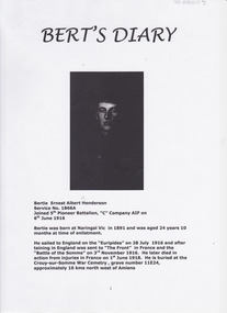
Document - Bert's Diary Bertie Ernest Albert Henderson, Circa 1916
Bertie Ernest Albert Henderson was born at Naringal in 1891 and was 24 at the time of enlistment. He fought in France and died from injuries in France on June 1, 1918. The entries relate to matters which relate to military procedures and duties, places visited in France and England, time spent at the front and on leave.For Australia, as for many nations, the First World War remains the most costly conflict in terms of deaths and casualties. From a population of fewer than five million, 416,809 men enlisted, of which over 60,000 were killed and 156,000 wounded, gassed, or taken prisoner.* Australian War Memorial Website Bertie Henderson was but one of these casualties and this diary gives an insight into the life of the average soldier. He records events from the mundane to conditions common to the war experience. Front page has photograph and typed enlistment details, followed by copy of enlistment paper and numerous pages of typed diary entries dated from July 1916. Other entries give day only with no year. Back cover has basic family tree.warrnambool, naringal, ernest albert henderson, 5th pioneer batallion, world war 1, amiens, crouy-sur somme -
 Mont De Lancey
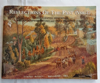
Book, Reflections of the Past (Vol. 2), 2001
Following the success of Volume 1, this follow-up edition is slightly different to the first one by gathering photos together under some new headings More attention is given to some aspects of local history, the pioneer families and community organisations than previously. The historical society's main interest is the history of the Dandenong Ranges and the communities of Belgrave, Tecoma, Upper Ferntree Gully, Upwey and surrounds.A photographic history of Belgrave, Upwey, Tecoma and Upper Ferntree Gully. The front cover is of a painting 'Wintry Sunset Belgrave 1913' from a series of 36 paintings by Charlie Hammond between 1910 and 1953. It is of the country town, Belgrave, showing a dirt road with a bullock team, with trees surrounding the road. Inside, are black and white and coloured photographs of paintings, people in general life and historical information about the areas noted. Pp.104.non-fictionFollowing the success of Volume 1, this follow-up edition is slightly different to the first one by gathering photos together under some new headings More attention is given to some aspects of local history, the pioneer families and community organisations than previously. The historical society's main interest is the history of the Dandenong Ranges and the communities of Belgrave, Tecoma, Upper Ferntree Gully, Upwey and surrounds. australian history, history of the dandenong ranges victoria, history victoria -
 Bendigo Historical Society Inc.
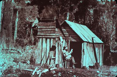
Slide - DIGGERS & MINING. LIFE OF THE SELECTORS, c1955
BHS CollectionDiggers & mining. Life Of The Selectors. Man sitting outside his one room wooden hut, the name Howard above the doorway. Appears to be an out house in front of the hut. He has many of the items he would require around him, fry pan, axes saw. The letters MO are engraved in a large tree on the left of scene. Markings: Life Of The Selectors 1860-1890, Set 432 No.6 ''The Bushman'' reproduced in ''The Story of the Camera in Australia.'' Cato, J., 1955. Used as a teaching aid.Visual Education Centreeducation, tertiary, goldfields -
Lakes Entrance Historical Society
Book, Walton, Cassay, Charles Sparks Descendant Tree, 2008
... Blay and John Gall and some of their life stories. Charles ...A list of descendants of Charles Sparks, Thomas Blay and John Gall and some of their life stories.genealogy -
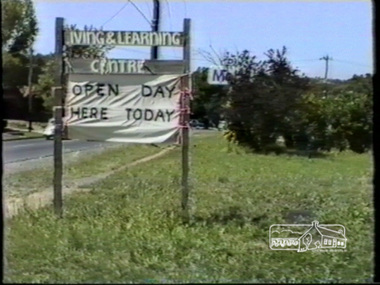 Eltham District Historical Society Inc
Film - Video (VHS), Open Day Eltham Living and Learning Centre, 1988
This cottage-like dwelling has changed ownership several times since it was first built in the 1850s by local tanner John Pearson. The Living and Learning Centre as we know it today is the product of the energetic, reforming era of the Whitlam Government. Set up by the local council in 1974. Unedited amateur video (filmed by Vivienne?) with some voiceover and chatting with others. Significant VHS tape noise/flicker and colour pulsing. Opens with Living & Learning Centre sign on Main Road and “Open Day Here Today” attached to it. Views of entrance into carpark, dog obedience class demonstration near entrance, leadlight construction display in workshop, basket weaving, face painting, exterior garden landscape with herb garden, brick pottery shed, peppercorn tree, children’s activities, interior views showing artworks of life drawings, general engagement with other people (audio), candle room, pottery, children’s entertainer in garden, wool spinning, some attempts at engagement with Claire Fitzpatrick, Thai Chi demonstration, floral presentations, patchwork, needlepoint, knitting, some interior scenes very dark, weaving, cane basket weaving.VHS Video cassette (poor quality) Converted to MP4 file format 00:31:39; 746MBeltham living and learning centre, open day, dog obedience class, leadlight, basket weaving, face painting, artworks, life drawing, candle room, pottery, wool spinning, claire fitzpatrick, thai chi, patchwork, needlepoint, knitting, weaving, cane basket weaving, main road, eltham, video recording, shire of eltham archives -
 Wangaratta RSL Sub Branch
Work on paper - Envelope Art
One of a series of illustrated envelopes which once contained letters drawn by a soldier/s and sent to Mrs MacDonald of 32 Grey Street Wangaratta.Victoria's 2/24th Infantry Battalion was raised in Wangaratta in July 1940. They were welcomed with open arms by the local community as they rapidly built up their numbers. The people of Wangaratta adopted the Battalion and they became known as "Wangaratta's Own" because of the time the battalion spent in the town during its formative period prior to deployment overseas. Many of the soldiers maintained life long friendships with the people of Wangaratta. Even though the Battation was disbanded in 1946 members and their families return each year, in November, for a commemorative service at the 2/24th Battalion Memorial Wall at the Wangaratta Cemetery.Cream paper envelope with drawing of war scene - cannon in front of hut and palm trees, ambulance in centre and bomb exploding below aircraft in sky.Top left - AIR MAIL Top right - postage stamp Left side - AIF Censor stamp Right side Mrs M MacDonald "Monald" 32 Grey Street Wangaratta Victoria Australia ww2, envelope art -
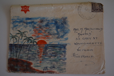 Wangaratta RSL Sub Branch
Work on paper - Envelope Art
Envelope Art made during WW2 Victoria's 2/24th Infantry Battalion was raised in Wangaratta in July 1940. They were welcomed with open arms by the local community as they rapidly built up their numbers. The people of Wangaratta adopted the Battalion and they became known as "Wangaratta's Own" because of the time the battalion spent in the town during its formative period prior to deployment overseas. Many of the soldiers maintained life long friendships with the people of Wangaratta. Even though the Battation was disbanded in 1946 members and their families return each year, in November, for a commemorative service at the 2/24th Battalion Memorial Wall at the Wangaratta Cemetery.Cream paper envelope with coloured picture of sun setting over water with palm trees in foregroundTop left - ACF in red star / AIR MAIL Top right - postage stamp Right side Mrs M MacDonald "Monald" 32 Grey Street Wangaratta Victoria Australiaenvelope art, ww2