Showing 333 items
matching train world
-
 Falls Creek Historical Society
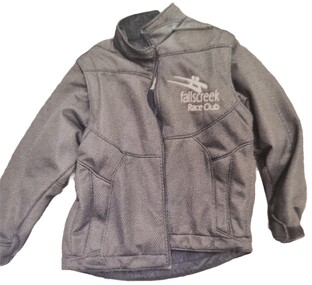
Clothing - Falls Creek Race Club Jacket, 2011
The Falls Creek Race Club was started in the late 60's by Rodney Moss assisted by Bob Howe from Albury Ski Club and Geoff Henke from Moloney's. The club ran races on the summit every weekend and later started the training squad. Its aim is to promote all the skills of skiing and snowboarding and to improve the safety and enjoyment of the sport for all age groups. As an athlete's skills Improve so they can begin to train and race at Children's level races and move on to Junior and Senior levels, possibly aspiring to the Masters Circuit or State and National Teams. Hundreds of children have been involved over the past four decades and the program has produced a number of skiers who have been successful at national and international levels. Falls Creek has produced Olympians Ross and Malcolm Mine, Joanne Henke, Jenny Altermatt, Steven Lee in Alpine skiing. Dick Walpole and Chris Heberle in Cross Country, Britteny Cox, Paul and Adrian Costa in Freestyle Moguls. Many others have represented in National Teams at World Championship events.This item is significant because it represents the Falls Creek Race Club which has nurtured many skiers, some of whom progressed to become representatives in international sporting events.A waterproof jacket with padded sections in the arms. The Falls Creek Race Club logo is embroidered in white on the left top chest area.Falls Creek Race Club logofalls creek race club, race club clothing -
 Mrs Aeneas Gunn Memorial Library
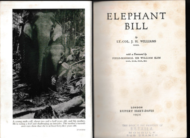
Book, J.H. Williams, Elephant Bill, 1956
Though he was officially known as Lt. Colonel J.H. Williams, the author was known to the world at large as Elephant Bill. That is because he spent 25 years living with the elephants in the mountains and forests of Burma. There he trained them to haul teak logs out of the isolated jungles. Yet this is also a story of great courage because when the Second World War struck, it also came to Burma. The Japanese Imperial Army planned to confiscate the Burmese elephants, drafting them to make the bridges and railways they needed to invade India. When he learned of these plans to put his beloved animals to a war-like purpose, Elephant Bill knew what had to be done. The mighty kings of the jungle had to be evacuated to safety. Elephant Bill is thus the story not only of the peaceful days in the jungle, starting in 1921, but also the story of the largest elephant rescue in history. It tells the amazing account of how Elephant Bill, along with his friends and family, rode 45 of the great beasts across the mountains of Burma, before reaching safety in faraway India. Collapse summaryIll, p.245.non-fictionThough he was officially known as Lt. Colonel J.H. Williams, the author was known to the world at large as Elephant Bill. That is because he spent 25 years living with the elephants in the mountains and forests of Burma. There he trained them to haul teak logs out of the isolated jungles. Yet this is also a story of great courage because when the Second World War struck, it also came to Burma. The Japanese Imperial Army planned to confiscate the Burmese elephants, drafting them to make the bridges and railways they needed to invade India. When he learned of these plans to put his beloved animals to a war-like purpose, Elephant Bill knew what had to be done. The mighty kings of the jungle had to be evacuated to safety. Elephant Bill is thus the story not only of the peaceful days in the jungle, starting in 1921, but also the story of the largest elephant rescue in history. It tells the amazing account of how Elephant Bill, along with his friends and family, rode 45 of the great beasts across the mountains of Burma, before reaching safety in faraway India. Collapse summary world war 1939-1945 - campaigns - burma, elephants - burma -
 Mrs Aeneas Gunn Memorial Library
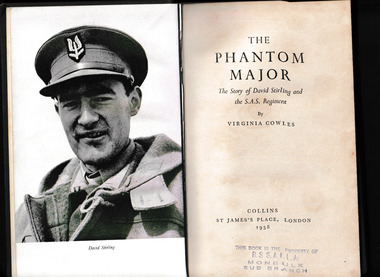
Virginia Cowles, The phantom major, 1958
In the dark and uncertain days of 1941 and 1942, when Rommel's tanks were sweeping towards Suez, a handful of daring raiders were making history for the Allies. They operated deep behind the German lines, often driving hundreds of miles through the deserts of North Africa. They hid by day and struck by night, destroying aircraft, blowing up ammunition dumps, derailing trains, and killing many times their own number. These were the SAS, Stirling's desert raiders, the brainchild of a deceptively mild-mannered man with a brilliant idea. Small teams of resourceful, highly trained men would penetrate beyond the front lines of the opposing armies and wreak havoc where the Germans least expected it.Index, ill, p.352.non-fictionIn the dark and uncertain days of 1941 and 1942, when Rommel's tanks were sweeping towards Suez, a handful of daring raiders were making history for the Allies. They operated deep behind the German lines, often driving hundreds of miles through the deserts of North Africa. They hid by day and struck by night, destroying aircraft, blowing up ammunition dumps, derailing trains, and killing many times their own number. These were the SAS, Stirling's desert raiders, the brainchild of a deceptively mild-mannered man with a brilliant idea. Small teams of resourceful, highly trained men would penetrate beyond the front lines of the opposing armies and wreak havoc where the Germans least expected it. world war 1939-1945 - campaigns - north africa, great britain - special air service -
 Mrs Aeneas Gunn Memorial Library
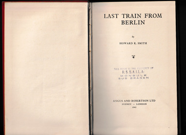
Book, Angus and Robertson, Last train from Berlin, 1943
Memoirs of an American correspondent in pre-war berlinp.290.Memoirs of an American correspondent in pre-war berlingermany - history - 1933-1943, world war 1939-1945 - personal narratives - united states -
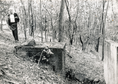 Wonga Park Community Cottage History Group
Photograph (sub-item) - Black and White, The remains of the Ammunition Store on Stane Brae, 1984. During World War II soldiers were trained here. Mr. Fred Renton on left
-
 Royal District Nursing Service (now known as Bolton Clarke)
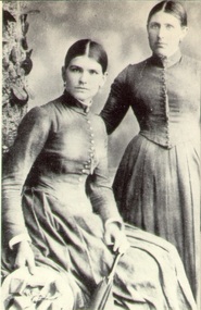
Photograph - Photograph, sepia, c.1892
This is the first photograph taken of Trained nurses, who worked with the Melbourne District Nursing Society (MDNS) and has been kept in their Archives (now RDNS) since that time. The photograph, taken about 1892, records the uniforms worn by MDNS Nurses in that era, and records images of Nurse Kennedy, who commenced with the Society at the end of 1891, and worked in the Western District of the CBD until the end of 1893; and Lucy Smith who worked in the Eastern District of the CBD between April 1892 - June 1893 when she left to get married. Nurse Smith trained at the Nightingale Training School for Nurses at St. Thomas's Hospital in London, the first professional nursing school in the world and as such she was given the position of the first 'Head Nurse' at MDNS. Though Florence Nightingale never worked at St. Thomas’s she did form the curriculum for the nurses training and received regular reports regarding the probationers, as well as receiving the nurses in her home during the latter part of their training. According to Lucy's family she met Florence Nightingale. The photograph shows two of the three Trained nurses employed by MDNS at that time. All Nurses employed by MDNS from its inception in 1885 were trained and received their qualification in a Hospital, but in those times were called 'Nurse'. In Melbourne in 1885 it was recognized that skilled nursing was needed in the inner city to care for the sick poor in their own homes. On the 17th of February a meeting was held with prominent Melbourne citizens, five gentlemen and fourteen ladies. ‘Dr. Caffyn and Rev. Charles Strong explained the objects and scope of District nursing Societies that had been formed in other towns’ in UK. On that day the Melbourne District Nursing Society (MDNS) was founded, the first District Nursing Society in Australia. Subsequent meetings were held to form a Committee and to draw up a Code of Rules of the Society. It was decided only nurses who had attended a Nurses Training School and were fully qualified would be employed by the Society, and that the Nurses would keep a daily journal of their work. After interviewing several candidates, the first Trained Nurse, Mrs. Ferguson, was employed with a salary of £100 per annum and commenced work on the 1st of May 1885. She was employed for three months initially, but this was soon extended, “on the understanding she will make arrangements to live in the more immediate vicinity of her district”. A doctor was consulted before any person was seen. In rotation, a member of the Superintendence Sub-Committee supervised the Nurse’s visits and could assist to alleviate some of the poor social conditions they found. Though only Trained nurses were employed, the term ’Nurse’ was used in those days. Lady Janet Clarke, a philanthropist, was one of the first two Vice-presidents and President from 1888 until 1908 (except when overseas); she was a driving force in the Society. She held the first fund raiser for the Society at her home ‘Cliveden’ and went on to help organize many functions where she, along with Committee members, manned the stalls to raise funds. She also took her turn to accompany the Nurse, and was noted for her kindness and benevolence. Over the years the Committee, which was made up of 80% ladies, worked tirelessly for the Society; many Auxiliaries were formed. A second Trained nurse, Mrs. Joanna Cannon, was employed in late 1885, with a trial period of six months which was extended. She and Mrs Ferguson were the stalwarts of the Society in the early years, Nurse Cannon remaining with the Society for four years and Nurse Ferguson for five years, though both had a short break due to the heaviness of the work. Nurse’s salaries were reduced to account for the cost of uniforms, and again in later years when establishments were rented by the Society and the nurses could now live in the Nurses Home. The two Nurses worked in the now CBD, ie from Spencer Street to Spring Street and from Victoria Parade to Flinders Street. At that time they walked the streets and lane ways amid the slums of inner Melbourne carrying their nursing bags containing lotion, ointments, powders, liniment, bandages, dressings, a case of spirits, and the Nurse's own clean apron, soap and small towel. They supplied equipment on loan, such as earthenware hot water bottles, splints, urinals, bed pans, bed cradles, feeding mugs, and air-cushions as well as providing blankets and clean bed linen, and nightdresses as necessary. From its inception the Society was at the forefront of health care and liaised with doctors. They provided high quality nursing care to a range of people, often in destitute situations, some lying on rags on the floor as they had no bed, others with just a bed and maybe a thin blanket, a chair and nothing else. Their ages ranged from babes, children, adults to the elderly. The Nurses gave medications as ordered, dressed wounds e.g. to the injured, and surgical cases, and to those with leg ulcers; attended to patients with ‘surgical ailments’ such as ‘hip disease’; gave care to those with acute illnesses such as bronchitis, pleurisy, pneumonia, measles, and scarlet fever, as well as those with chronic illnesses such as consumption (tuberculosis), heart disease, arthritis, cancer, debility, neuritis and paralysis. They educated their patients, and their Carers, in the curing and prevention of disease; teaching the importance of hygiene, cleanliness, ventilation and good nutrition. They taught them, by verbal instruction and demonstration, how to make poultices, to make and apply bandages, apply medical appliances such as splints; and the Nurses supplied milk, beef tea and cooked soup when needed. As the work increased a third Trained nurse was employed but this was arduous work, particularly in the heat of summer and many Nurses only remained with the Society for several months. In 1891 the first Nurses Home was rented for 1 year at £65 per annum at 66 Cardigan Street, Carlton; Nurses wages were now £60 per annum. A Doctor gave lectures from the Home to the public on the understanding and prevention of diseases. The Society decided to commence a Midwifery Service and Nurse Fowler, who had previously worked for the Society, was re-employed as their first trained Midwife. She began home births in August 1893 giving them Ante Natal care, taking midwifery bundles and providing clothes for the babe and mother as needed. Following birth, she gave Post-natal care to the mother and babe twice a day for three days and then daily for a week, and longer if required. She resigned after twelve months and Nurse Wilkie was appointed to the position. As well as walking, the nurses used Public transport in the limited areas it ran, though a taxi was used by the Nurses and Midwife in emergencies and at night. Late in 1891 the Society moved to larger rented premises at 49 Drummond Street and in 1902 moved to 188 Leicester Street, Carlton Sepia Photograph of two Melbourne District Nursing Society (MDNS), Trained nurses; on the left is Nurse Kennedy (sitting) and to the right Nurse Lucy Smith (standing). They are wearing the MDNS uniform of a long grey frock. Over this they are wearing a grey long sleeve jacket with self buttons down the centre. The jacket forms a V at the waist. Nurse Kennedy has a round visage with her central parted dark hair drawn back. She is wearing ear rings and holds the top of a closed umbrella in her left hand, the feral rests on the ground. She has a straw hat in her right hand. Nurse Smith has a long visage; is wearing ear rings and her central parted dark hair is drawn back. Her right arm is extended holding the back of the chair on which Nurse Kennedy sits. melbourne district nursing society, mdns, mdns uniforms, mdns first 'head nurse', rdns, royal district nursing service, trained nurse kennedy, trained nurse lucy smith -
 Royal District Nursing Service (now known as Bolton Clarke)
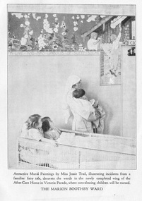
Photograph - Digital image, 1931
The Marion Boothby Ward in the 'MDNS After Care Home' opened in 1930 and was named in honour of Mrs Noel (Marion) Boothby, Life Governor and generous supporter of the Melbourne District Nursing Society who passed away in 1929. The photograph portrays a Trained nurse (Sister) holding a young child viewing the newly completed mural by Miss Jessie Traill. Two young children in a cane wicker trolley look on.Miss Jessie Traill 29/7/1881 - 15/5/1967 is today considered one of Australia's most remarkable printmakers. She studied painting and drawing at the National Gallery of Victoria. She spent over 3 years as a VAD nurse based in Rouen, France during World War 1. https://nga.gov.au/Traill/Chronology2.cfm The Melbourne District Nursing The Society (MDNS) were pioneers in recognizing the need for premises where patients too ill to be in their own home, but not ill enough to go to hospital, was needed. The MDNS had purchased its first premises, 'Floriston' at 39 Victoria Parade, Collingwood in 1914 and were able to purchase land next to No. 39, where the Society built the After-Care Home, it became No. 45 Victoria Parade, for these patients, and for patients from Hospitals. It was opened in July 1926 and the name of the Society then became ‘Melbourne District Nursing Society and After-Care Home’ (‘Hospital’ from 1934), Many children were nursed there, some long term during the Polio epidemic and two School Teachers were employed. The Society now ran two divisions, the After-Care with its own Sisters and nurses, and the District division which only employed Sisters. Black and white digital image of a Trained nurse (Sister) and 3 children in the Marion Boothby Ward in the Melbourne District Nursing Society After Care Home. The photograph portrays a Sister in her white uniform and white veil over her short curled hair. She is holding a young boy who has short dark hair, in her arms. He has a blanket around him. They are viewing the newly completed mural on the wall by Miss Jessie Traill. Two young girls, one with dark straight hair and the other with lighter coloured curled hair are sitting up together in a cane wicker trolley look up at the mural. The mural depicts flowers and children.melbourne district nursing society, after-care home, mdns, mrs noel (marion) boothby, miss jessie traill -
 Falls Creek Historical Society
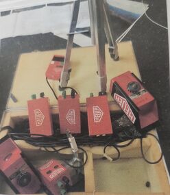
Equipment - Race Club Timing equipment - TAG HEUER
The Falls Creek Race Club was started in the late 60's by Rodney Moss assisted by Bob Howe from Albury Ski Club and Geoff Henke from Moloney's. The club ran races on the summit every weekend and later started the training squad. Its aim is to promote all the skills of skiing and snowboarding and to improve the safety and enjoyment of the sport for all age groups. As an athlete's skills Improve so they can begin to train and race at Children's level races and move on to Junior and Senior levels, possibly aspiring to the Masters Circuit or State and National Teams. Hundreds of children have been involved over the past four decades and the program has produced a number of skiers who have been successful at national and international levels. Falls Creek has produced Olympians Ross and Malcolm Mine, Joanne Henke, Jenny Altermatt, Steven Lee in Alpine skiing. Dick Walpole and Chris Heberle in Cross Country, Britteny Cox, Paul and Adrian Costa in Freestyle Moguls. Many others have represented in National Teams at World Championship events. The TAGHEUER company was established by Edouard Heuer in 1860 n St-Imier, Switzerland. He patented his first chronograph or timepiece in 1882. The company has operated continuously from that time. In the early 1970s, Heuer’s Electronics Division developed the Centigraph, a timing system initially used by the Ferrari racing team. This system allowed times to be recorded to 1/1000 second. It was also capable of timing multiple cars or competitors, with the number of laps, the time of the last lap and total time, being printed out on the spot. This system has been adapted and used in a range of sports including numerous World Ski Championships and the Winter Olympic Games. The TAGHAEUR system has been certified by the FIS (Fédération Internationale de Ski). TAGHEUER ceased production of their sports timing systems at the end of 2020. This timing system is significant because it was used by the Falls Creek Race Club to time skiers in events and training, some of whom progressed to become representatives in international sporting events.A steel box containing a variety components which make up the timing system used by the Falls Creek Race Club,On each component - TAG HEUERfalls creek race club, falls creek activities, falls creek olympians, timing equipment falls creek, tag heuer timing -
 Falls Creek Historical Society
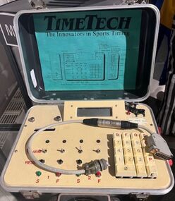
Equipment - Race Club Timing equipment - TimeTech
The Falls Creek Race Club was started in the late 60's by Rodney Moss assisted by Bob Howe from Albury Ski Club and Geoff Henke from Moloney's. The club ran races on the summit every weekend and later started the training squad. Its aim is to promote all the skills of skiing and snowboarding and to improve the safety and enjoyment of the sport for all age groups. As an athlete's skills Improve so they can begin to train and race at Children's level races and move on to Junior and Senior levels, possibly aspiring to the Masters Circuit or State and National Teams. Hundreds of children have been involved over the past four decades and the program has produced a number of skiers who have been successful at national and international levels. Falls Creek has produced Olympians Ross and Malcolm Mine, Joanne Henke, Jenny Altermatt, Steven Lee in Alpine skiing. Dick Walpole and Chris Heberle in Cross Country, Britteny Cox, Paul and Adrian Costa in Freestyle Moguls. Many others have represented in National Teams at World Championship events.This timing system is significant because it was used by the Falls Creek Race Club to time skiers in events and training, some of whom progressed to become representatives in international sporting events.A timing console stored inside a black metal box. A connecting electrical cord to attach the console to the TAGHEUER equipment is included.falls creek race club, falls creek olympians, timing equipment falls creek, timetech -
 Falls Creek Historical Society
Badge - Falls Creek Ski School Race Club
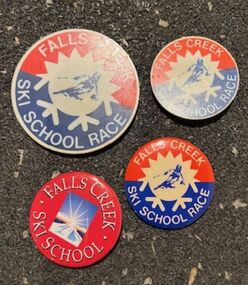
The Falls Creek Race Club was started in the late 60's by Rodney Moss assisted by Bob Howe from Albury Ski Club and Geoff Henke from Moloney's. The club ran races on the summit every weekend and later started the training squad. Its aim is to promote all the skills of skiing and snowboarding and to improve the safety and enjoyment of the sport for all age groups. As an athlete's skills Improve so they can begin to train and race at Children's level races and move on to Junior and Senior levels, possibly aspiring to the Masters Circuit or State and National Teams. Hundreds of children have been involved over the past four decades and the program has produced a number of skiers who have been successful at national and international levels. Falls Creek has produced Olympians Ross and Malcolm Mine, Joanne Henke, Jenny Altermatt, Steven Lee in Alpine skiing. Dick Walpole and Chris Heberle in Cross Country, Britteny Cox, Paul and Adrian Costa in Freestyle Moguls. Many others have represented in National Teams at World Championship events.These badges are significant because they represent the Falls Creek Ski School and the Falls Creek Race Club which have nurtured many skiers, some of whom progressed to become representatives in international sporting events.Four red, white and blue badges. Three has an image of a skier in the centre, the other has an image of sun over a mountain Falls Creek Ski School Racefalls creek race club, falls creek olympians -
 Falls Creek Historical Society
Photograph - Falls Creek Ski School Race Club
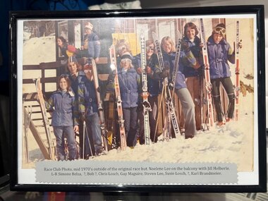
The Falls Creek Race Club was started in the late 60's by Rodney Moss assisted by Bob Howe from Albury Ski Club and Geoff Henke from Moloney's. The club ran races on the summit every weekend and later started the training squad. Its aim is to promote all the skills of skiing and snowboarding and to improve the safety and enjoyment of the sport for all age groups. As an athlete's skills Improve so they can begin to train and race at Children's level races and move on to Junior and Senior levels, possibly aspiring to the Masters Circuit or State and National Teams. Hundreds of children have been involved over the past four decades and the program has produced a number of skiers who have been successful at national and international levels. Falls Creek has produced Olympians Ross and Malcolm Mine, Joanne Henke, Jenny Altermatt, Steven Lee in Alpine skiing. Dick Walpole and Chris Heberle in Cross Country, Britteny Cox, Paul and Adrian Costa in Freestyle Moguls. Many others have represented in National Teams at World Championship events.This photograph is significant because it includes early members Falls Creek Race Club, some of whom progressed to become representatives in international sporting events including World Championships and Winter Olympics.A framed colour photograph of members of the Falls Creek Race Club standing outside the Club buiding.Beneath Image Race Club Photo, mid 1970's outside of the original race hut. Noelene Lee on the balcony with Jill Helberle. L-R Simone Belza, ?, Bob ?, Chris Losch, Guy Maguire, Steven Lee, Susie Losch, ?, Karl Brandmeier.falls creek race club, falls creek olympians -
 Melton City Libraries
Photograph, Edna Barrie, 1920, 1924, 1933 and 1940
SUMMARY - Edna (Myers) Barrie, 1918 – 2018, Profile Early Life Edna was born at Melton and delivered by Hannah Watts. Her mother Martha walked in the dark at night with her basket under her arm to the bridge over the Toolern Creek Bridge and into Sherwin Street to the corner of Yuille Street to Hannah’s house Lynch Cottage. Martha’s husband was away shearing and eventually heard the news of the birth of their blue eyed third child and second daughter. She was born into a family that was surrounded by music; her father played the “squeeze box” and mother the mouth organ. From an early age the family were aware of the great composers, a framed picture of Beethoven, Chopin, Schubert and Wagner hung above the door to the lounge room of their 4 roomed cottage, the room where the piano stood. Her life on stage started as a singer aged 6 years at the Melton Mechanics Institute Hall. Edna was born with a natural ear for music learning piano and singing from her older sister Marjorie who became an accomplished pianist and soloist and renowned music teacher in Melton and district. In the 1920s and 1930s concerts at the Melton Mechanics Institute were regular events were the local talent was fostered. The Myers children, like other children of Melton and Rockbank, studied singing, piano and elocution, sat examinations, entered in competitions in South Street Ballarat, Footscray and Melbourne. In 1929 a Sacred Concert was broadcast by 3AR from the Hall as part of the Back to Melton Celebrations. Marjorie Myers performed two of the items on the piano. Edna attended Melton State School 430 from 1924 – 1933. Her father Fred had also attended the same school. In 1924 the School staged Cinderella at the Melton Mechanics Institute Hall with a cast of 33 students. After completing her education a Melton she boarded in South Melbourne and attending Melbourne Girls High School (MacRobertson Girls High School), a school which recognized her musical attributes. She travelled home on the train on the weekends, sometimes getting off at Rockbank to save a few pennies in fares. Working life The early 1930s the Depression was a difficult time for a young woman to find work. Jobs were often menial and given to the youngest and therefore cheapest applicant. She worked as sales assistant at Polonskis and Myer in the city, and Irvines Modes in Footscray. Working to 1pm on Saturday, and when held up by a customer meant missing the train home. While at Myer Department store she lived at home and rode her bike to the Melton railway station. On one occasion she had a nasty fall when a part of her bicycle came loose causing the bike to crash rendering her concussed and injuring her nose. During the 1930s she was given a camera “a little snap” by Mrs Kelly her landlady. This began her interest in photography documenting family life at their “Burnbank” home. Musically, while at Myers she participated in annual performances held at The Kings Hall and the Myer Mural Hall. Working in the basement at Myers she was often embarrassed when her name was called, customers assuming she belonged to the Myer Family. Ken Myer worked in the basement at the same time handling the ‘Wheeler’, a wicker basket used for moving goods around the store. The family philosophy was for the children to start at the bottom and work their way up. Social life Social life in her teenage years was connected also with Scots Presbyterian Church. She attended Sunday School classes and received book prizes for attendance. She loved to read and welcomed the times when she received new book. She took part in the Sunday School Anniversaries and was presented with a Bible from the Superintendent, Henry Robinson for her assistance with the music. Marriage and War years In 1941 Edna married Ernest “Bonnie” Barrie. War in the Pacific was soon to break out. While in Sydney on their honeymoon they met up with Jim Barrie who was on his way to Canada via Hawaii just missing Pearl Harbour by two days. Jim became a Spitfire Pilot and joined the RAF and was based in England. He returned to Australia later in RAAF to fight the Japanese off the coast of New Guinea. The three eldest Barrie brothers were farmers and food producers and were thus except from military service. Edna and Bon were members of the VAOC- Volunteer Air Observers Corp entailing being rostered on duty as plane spotters. The women took shifts during the day and the men at night which involved staying overnight in the Shire Offices. Later the spotting tower was built in the plantation opposite the Post Office. Edna and Bon carried on with this from their home in Ferris Rd when the threat of invasion had ceased Community life Community life in Melton revolved around fund raising events for the Melton Mechanics Institute for the War effort and keeping up with maintenance for the Hall. In 1944 the Minister for Health gave approval for the Shire of Melton to open and Infant Welfare Centre inviting Edna to form part of the Committee with seven other women. In 1948 she was President of Melton Branch of the Victorian Health Centres Association. She volunteered this use of her car driving the person in charge, Sister Smith to visit mothers and their babies. In 1963, along with Betty Jones and Isabel Snell, Edna was instrumental in forming the 1st Melton Cub Pack and later supported the formation of the 1st Melton Scouts. During 1963 – 1968 she completed the Australian Boy Scout Association Cub Pack Preliminary Training and achieved her Wood Badge. Country Women’s Association In 1944-1996 she was a member of the Melton Branch Country Women’s Association (CWA), Melton Branch, Secretary of the Branch in 1945 – 1946 and Branch International Secretary 1970-1971. She worked with choir, music and drama interest groups within the branch attaining both first and second place in 1959, second place in 1952 Exhibition and second in Music in 1960 in the state. She was involved in their handicraft craft events, fund raising and musical events and singing competitions. During the 1950s she trained Trios and Quartets in part singing for the CWA competitions in Ballarat and Melbourne. It was at this time that she developed her skill as a conductor and trainer of choirs. She later auditioned for the Victorian Choir for alto parts believing she would stand a better chance of being chosen, because of her ability to sing in natural harmony. In 1962 she participated in the Tenth Australian Country Women of the World (ACWW) Triennial Conference “Australia Presents: CWA Massed Choir” in the Melbourne Town Hall. This event was recorded by Super Sound Spotlight on 45 extended play vinyl record. The songs were Australian music and words, for example The Silver Stars are in the Sky, The Graceful Swaying Wattle and Kookaburra. Edna continued with her interest in the Victorian Choir regularly meeting at the CWA Headquarters in Toorak for rehearsals. In 1974 she took part in the Australian Choir at the fourteenth Triennial conference of the ACWW Interfaith Service held at the Perth Concert Hall on the 13th of October. Arts and Culture Edna was also in the Choir of 3KZ Carols by Candlelight at the Myer Music Bowl in 1963 and 1964. Melton Choral Society. Edna was Director and Conductor in the 1970s performing at many community events such as Carols by Candle Light, Church Services, Easter and Palm Sunday services, Mothers Union and the 1976 Community Services Week Combined Church Service. The October – November 1978 Program covered the following: songs from the Musicals, Choral and Solo with Narratives, Guest Instrumental Item, Recitation Negro Spirituals and Australian Songs. Her involvement with church choirs included the Scots Presbyterian Church Choir Easter and Christmas performances and the 1967 Centenary Service. In 1980s the Melton Uniting Church Sacred Music Performances included The Crucifixion by Stainer, The Olivet to Calvary and other church Hymns. Edna was Musical Director of the Melton Amateur Theatrical Society and worked on performances in collaboration with Mabel Rogers on script and musical interpretation. Melton and District Historical Society Annual Art and Craft Show. First held in Melton Mechanics Institute Hall in 1973, it later took place in the in the Melton Community Hall. The Art Show was also run in conjunction with other community organizations such as Rotary and Girl Guides. Community history and research Melton streetscape and society Over 20 years commencing in the 1970s, Edna undertook extensive photographing of the changing streetscape of Melton’s High Street. She anticipated the impact of change on the community during the time of Melton’s rapid transition from a small farming district to a large urban community and this led to her extensively document and photograph many of the structures and landscape features of the township that have since been lost. She also meticulously recorded much of the contemporary life of the town and has left a significant legacy of archival material. Melton State School 100 Years Celebration, October 1970 Co-author with Mabel Rogers “The First 100 Years, 1870 – 1970” Assembled a collection of School Class Photograph and identified and compiled lists of names for future school history. She also assembled a photographic display for the 125th anniversary in 1995. Melton and District Historical Society (M&DHS) Foundation Member, 1968 Held President and Secretary positions from its inception Research associated with the classification of Heritage buildings Christ Church Classification C Scots’ Presbyterian Church Classification D Set up the storage and Catalogue system in the Office at the Willows Organised society visits to Heritage sites in and beyond the Shire of Melton, including Stathtulloh, Eynesbury, Deanside, ToolernVale sites including Merrywood (now demolished) Staughton Vale, Chirnside, Point Cook, Shwerkolts Cottage. 1970 – 1983 Melton and District Historical Society Letterhead. Staughton Memorial Light from early newspaper cutting in its location before restoration to present location. Sketch by Wendy Barrie. Designing and printing pamphlets, stationery, and other sale items with Willows title. M&DHS street naming research for new housing developments (1970 – 2000). Collaborated with Mary Tolhurst to research the names of early landowners and pioneer families connected to the first settlers. Researched Aboriginal names for inclusion on lists submitted to developers. An early example is the naming of Kuranjang and the street names associated with the McPherson family. Plains of Promise (Shire of Melton history) by Joan Starr (1985). Edna assisted with Historical Society materials and contributed her own research and photographs. Contacted and organised for Hubert Opperman to launch the book. (She was also present at his last bike ride at Rochester in 1995.) Western Metropolitan Groups of Historical Societies. Member attending meetings and representing Melton, also hosted the Group at Melton The Willows Member of the Committee of Management for the restoration of the “Willows” house the establishment of The Willows Park 1982 March - Official Opening of the Willows Park- Preparation and planning for the event. Involved in the collecting of items in the furnishing of the display rooms in the Willows house. Donated items and furniture from the Myers and Daley family houses. (19th century) Machinery Shed Establishment. Involved with Jeff Robinson in the construction and collection of machinery display Other significant sites Championed and participated in the restoration and preservation significant sites in Melton, including: restoration of the Staughton Memorial Light and its return to its present site restoration of the Pykes Grave (using EW Barrie earthmoving equipment) restoration and reconstruction of Dunvegan restoration and reconstruction of Macs Cottage, the management and Caretakers residence Melton State School War Memorial Gates removed from Unitt Street entrance and relocated to the Willows Park Donated the Barrie family single furrow plough which was standing at the Court House Plaza. It removed and to Council Depot and later missing. The plaque was taken to the Willows. Jimmy Melrose (aviator) cairn restoration at crash site in Melton South Donald Mackintosh (Olympic gold medallist marksman) grave site at the Melton Cemetery (Historical items held by the Myers family collection.) Houdini first flight at Diggers Rest. Edna’s father was shearing at Diggers Rest at the time and witnessed the flight. She attended the 90 year anniversary of the event at the site in 2000. Radio and electronics Edna’s husband Bon interest in wireless communication dates in the 1920s with the building of a crystal set in the early days of public broadcasting. At the Back to Melton Celebrations in 1929, 3AR broadcast a concert from the Melton Mechanics Institute on the 20th February at 8pm featuring Footscray City Band, James Hill baritone, Vera Carew Soprano, James Foran Tenor, Marjorie Myers Piano, and James Williamson Entertainer. Accompanists: Miss Agnes Ross and Mrs James Hill. The Myers children had recordings of their piano playing made onto the aluminium records, Martha Myers’ voice can be heard introducing an item. These were made in a studio in Melbourne. Marjorie was given a upright Gramophone by Donald Mackintosh in recognition of her talent and her contribution to the cultural life of Melton. The family were then able to listen to 78rpm recordings of the famous classical recordings. The turntable was hand wound metal stylus needles had to be regularly replaced. The aluminium disk needed a bamboo needle to prevent damage to the surface. Before electricity was introduced to Melton in 1939 the Mechanics Hall relied on generators to produce electricity. Bon Barrie, being mechanically minded, built a public address system for be used a community functions at the Hall and Recreational Park. By 1939 this was up and running and used for over three decades. A large Collection of 78rpm records provided music for dances, marching, parades and any public event needing music and microphones. The early system was portable and worked on batteries. CFA Radio Communication In the 1950s with the introduction two-way HF and later VHF very high frequency radio sets. Melton Rural Fire Brigade was part of the Bacchus Marsh Group. Radio sets where located in the Melton Fire Truck, and in the house of the Barrie family at Ferris Road. This was an ideal location to observe a 360 degree view in all directions when smoke appeared on the horizon. An antenna was erected beside the house. The set OX 7 was located in the kitchen and monitored 24 hours by the family. When an electrical fire occurred at the junction of the electricity to the house there was time to radio the fire station and summons the men working in the paddocks, thus saving the house from possible destruction. With the introduction of UHF – ultra high frequency Vinten Radios the signal was clearer and static and interference lessened and radio traffic became easier to read, and reduced noise levels in the household. VL3 LY Radio Base became the Group Headquarters was established in 1967. By 1970 the Brigades were: Melton, Rockbank, Sydenham, Toolern Vale, Diggers Rest, Truganina, and Werribee. In 1974 when the family moved to First Avenue, another antenna and a small building were erected adjacent to the residence and used to house the equipment, maps. Radio traffic consisted of regular schedule times and communication with adjoining groups of brigades such as Bacchus Marsh, Mt Macedon and Little River Groups. Many of the brigade and group base radios were situated in private residences and operated primarily by fire fighters wives who held the position of Communications Officer, either registered as a brigade member or informally. Edna was never registered as an operational brigade member but operated informally as an assistant to her husband Bon. She was however a member of the Melton Fire Brigade Ladies Auxiliary from its inception in 1968, a non-operational position. Edna kept up to date with radio procedure following the 1967 handbook; preparing maps, plotting compass points and taking notes on weather forecasts from the SA Border and Western District. Daily notes were taken in anticipation of fire warnings. These log books and daily radio traffic were incidental to the regular radio schedules. Emergency turnouts noted, burning off times and predicted location of smoke. In the summer fire season all TBF (total fire ban days were recorded.) In times of emergency the Barrie family assisted Bon the base radio operator to plot the position and location of fire trucks and to help clarify garbled radio traffic, keep notes and make telephone calls. These log books are held in the EE and EW Family Archive. Melton Uniting Church Edna founded the Church Opportunity with Maisie Robinson in 1975 in the Melton South Methodist Church building. Methodist and Presbyterian Churches of Melton had combined severing their long held connection with Bacchus Marsh. A Manse had been recently built for the Melton Minister. At a Parish Committee meeting at the Melton South Church it was suggested to use the building as an Opportunity Shop. It opened in July 1975, and it raised $1,600 contribution to the church budget in 1976. In 1977 The Uniting Church in Australia was formed and the Melton South Uniting Church Opportunity shop continued to go from strength to strength expanding the buildings providing the welfare needs of the community. Archive Set up by Edna Catalogued items dating from 1857 Minute Book and set ongoing system and storage of items of heritage. Melton Un Awards and recognition of service to the Melton community Rotary Award for Community Service, 1980 Victoria 150th Anniversary Celebrations contributions, 1985 Life Membership of the Melton and District Historical Society (M&DHS), 1989 Extra-Ordinary Contribution for years of service to M&DHS, 1992 Long Service for Exceptional Service MD&HS, 1993 Royal Historical Society of Victoria Award of Merit, 1997 Shire of Melton Certificate of Appreciation for continued support and dedication as a member of MD&HS to the preservation of Melton’s History, 1998 Centenary of Federation Peoplescape (Canberra) Melton Shire nomination, 2001 Uniting Church Melton Life Membership of the Opportunity Shop Uniting Church in Australia Commission for Mission for 30 years of hard work and dedications to the Uniting Church, 2007 Uniting Church Adult Fellowship Certificate appreciation in recognition of valuable support through the “Sammy” Stamp Fund Neighbourhood Watch 5 year award Photographs of Edna at different ageslocal identities -
 Melton City Libraries
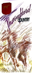
Pamphlet, Thoroughbred Country, c.1985
"Melton has a long and celebrated history of horse breeding and racing. Draught horses were a crucial aspect of life in the early days of European settlement, and were heavily depended upon for both transport and agricultural labour. Peppercorn trees at the corner of Station and Brooklyn roads have been associated with a horse trough installed there to provide a drink to workhorses carting produce to the chaff mills and railway station south of Melton.20 Breeders, trainers and harness drivers in the area later became such an influential force in the equine industry that this came to be a defining aspect of the district’s identity and reputation.Pioneer of the Victorian horse racing industry and early Rockbank squatter William Cross Yuille was one of the earliest importers of stud racehorses in the district in the 1850s. A leading sports editor and writer, Yuille established bloodstock auctioning agency W. C. Yuille & Co. and was involved in the compilation of the first Australian Stud Book, which ensures the integrity of thoroughbred breeding in Australia. According to early Melton chronicler Alexander Cameron, horse races were first organised in the area by Rockbank farmer William Keating. Keating owned racehorses of his own, and many brought horses from Melbourne for the events, which ‘drew large gatherings’.22 Melton Racing Club meetings were held on the Exford Estate with the permission of H. W. Staughton, who built a small wooden grandstand in 1882. Other early races and sports meetings are said to have been held in the vicinity of the current-day Melton golf course.23 An 1884 article reported that Melton’s ‘race programme … equals any put forth by country towns of far greater size’. Ernest Clarke was another important figure in the early horse racing industry in Melton. He established the Melton Stud in 1902, which bred numerous successful racehorses. Perhaps most notably The Welkin, one of the most famous stallions in Australian horse racing in the early twentieth century. The Welkin sired Gloaming, bred by Clarke at the Melton stud in 1915 and one of Australia’s greatest champion racehorses. During a long and prestigious career in both Australia and New Zealand, Gloaming achieved a triumphant 57 wins out of 67 starts and won a record amount of prize money. Ken Cox purchased the Stockwell Stud in Diggers Rest in 1957 and developed it into one of the largest and most renowned thoroughbred breeders in Australia. With its top-class facilities, international design standards and scientific methods, Stockwell became ‘the flagship of the Victorian breeding industry’.26 As well as racing studs, numerous trotting tracks were established on the flat plains around Melton in the 1960s.27 Other studs to play a leading role in the development of Melton as thoroughbred country were Cornwall Park and Merrywood at Toolern Vale, St John’s Lane Stud at Diggers Rest and Birchwood, Teppo Park and Dreelburn in the far north-east of the shire, near Sunbury. By 1985, thoroughbred horse breeding was such big business in Melton that the shire council adopted the slogan ‘The Heart of Thoroughbred Country’, which was used throughout its promotional material.29 But the slogan contained deeper meaning and was not just about Melton’s great equine industry and thoroughbred champions, the council explained: ‘“Thoroughbred Country” should be seen as a new concept of Melton, as a place where people can achieve the “Thoroughbred” ideal, excellence in all aspects of life’. The aim of the council in promoting ‘The Heart of Thoroughbred Country’, was ‘to instil in present and future residents the feeling that this is a place that is better than others. A place to be proud of’. In 1988, Melton’s champion reinsman Gavin Lang won his 176th race of the season, claiming the national harness racing record for the most wins in a single season.The following year, the first Melton Plate was held at Moonee Valley Racecourse, cementing the district’s importance in the harness racing industry. The inaugural winner was Victorys Phil, owned by local Danny Mullan. By the 1990s, Melton had earned the title of the ‘Home of Harness Racing in Victoria’. State-of-the-art, world-class harness racing facility and entertainment complex Tabcorp Park opened in Melton in 2009. In 2011, the Shire of Melton was home to over 140 registered trainers and over 1,200 horses. The municipality’s continuing leadership and influence in the industry today is a testament to the skills, talents and leadership of the local community over its history".Shire of Melton pamphlet of a map and information of the equine industry in Meltoncouncil -
 Melton City Libraries
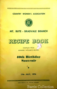
Booklet, Country Women's Association Recipe Book, 1974
From 1944-1996, Edna Barrie was a member of the Melton Branch Country Women’s Association (CWA), Melton Branch, Secretary of the Branch in 1945 – 1946 and Branch International Secretary 1970-1971. She worked with choir, music and drama interest groups within the branch attaining both first and second place in 1959, second place in 1952 Exhibition and second in Music in 1960 in the state. She was involved in their handicraft craft events, fund raising and musical events and singing competitions. During the 1950s she trained Trios and Quartets in part singing for the CWA competitions in Ballarat and Melbourne. It was at this time that she developed her skill as a conductor and trainer of choirs. She later auditioned for the Victorian Choir for alto parts believing she would stand a better chance of being chosen, because of her ability to sing in natural harmony. In 1962 she participated in the Tenth Australian Country Women of the World (ACWW) Triennial Conference “Australia Presents: CWA Massed Choir” in the Melbourne Town Hall. This event was recorded by Super Sound Spotlight on 45 extended play vinyl record. The songs were Australian music and words, for example The Silver Stars are in the Sky, The Graceful Swaying Wattle and Kookaburra. Edna continued with her interest in the Victorian Choir regularly meeting at the CWA Headquarters in Toorak for rehearsals. In 1974 she took part in the Australian Choir at the fourteenth Triennial conference of the ACWW Interfaith Service held at the Perth Concert Hall on the 13th of October. Recipes from the members of the Bradvale Branchlocal significant events, local identities -
 Melton City Libraries
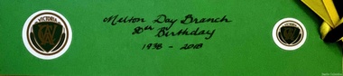
Memorabilia, Country Women's Association, Melton Day Branch, 2018
In 1944-1996 Edna Barrie was a member of the Melton Branch Country Women’s Association (CWA), Melton Branch, Secretary of the Branch in 1945 – 1946 and Branch International Secretary 1970-1971. She worked with choir, music and drama interest groups within the branch attaining both first and second place in 1959, second place in 1952 Exhibition and second in Music in 1960 in the state. She was involved in their handicraft craft events, fund raising and musical events and singing competitions. During the 1950s she trained Trios and Quartets in part singing for the CWA competitions in Ballarat and Melbourne. It was at this time that she developed her skill as a conductor and trainer of choirs. She later auditioned for the Victorian Choir for alto parts believing she would stand a better chance of being chosen, because of her ability to sing in natural harmony. In 1962 she participated in the Tenth Australian Country Women of the World (ACWW) Triennial Conference “Australia Presents: CWA Massed Choir” in the Melbourne Town Hall. This event was recorded by Super Sound Spotlight on 45 extended play vinyl record. The songs were Australian music and words, for example The Silver Stars are in the Sky, The Graceful Swaying Wattle and Kookaburra. Edna continued with her interest in the Victorian Choir regularly meeting at the CWA Headquarters in Toorak for rehearsals. In 1974 she took part in the Australian Choir at the fourteenth Triennial conference of the ACWW Interfaith Service held at the Perth Concert Hall on the 13th of October. Items celebrating 80 years of Country Women's Association and the closure of the Melton branchlocal significant groups, local identities, local special interest groups -
 Indigo Shire Council
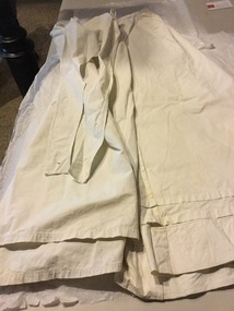
Petticoat, 1918
Inscribed Staff Nurse Rose Eleanor Carter A.A.N.S. of Chiltern, b.1886 Wangaratta, d.1951 Worn in 1918, also worn by younger sister Hester. Trained at Wangaratta District Hospital, served in India during WW1 On loan from Susan HeatherTwo pieces - undergarments worn by 2nd Hall nurse. One with bib and straps and button hole on waist. The other one with waist opening and five hooks, two rows of pleating above hem. Cotton. Stained."H Carter" and "Carter T" witten in ink on inside of waistbands. "CARTER" external waistband of bib garment.susan heather, rose eleanor carter, suitcase, shoes, hester carter, world war 1 nurse -
 Wodonga & District Historical Society Inc
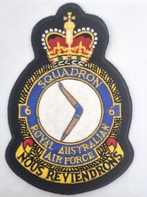
Functional object - RAAF Cloth Badge and Pass Out Dinner Card
Leslie William Cole was born in January 1920 in Albury, the first child of William James Cole and Gwendoline Fair. Les spent most of his childhood living with his grandparents in Bethanga, Victoria. In 1934 when he finished school, Les moved into Wodonga. His first job was at Mates Timber Yard. He later worked for Mylons of Wodonga driving taxis and buses. In 1939 after completing militia training, Les applied to enlist with the RAAF and eventually trained as an aircraft mechanic. He was posted to the 6th Squadron, serving in Port Moresby, Milne Bay and Goodenough Island before returning to the RAAF base in Sale, Victoria. On discharge. Les returned to Wodonga and resumed working with Mylons. After a range of jobs, Les and his wife Lorna operated a shop in Ariel Street, Wodonga. In the community, Les was a founding member of Wodonga Lions Club. He also joined the Civil Defence which was a predecessor off the SES. He became the Communications Officer and trained other members. Les became the first controller of the Wodonga Branch of the State Emergency Service, a position he held for 17 years. The new SES headquarters was named in his honor. In retirement he also worked as a volunteer community driver. Les was also named Wodonga Citizen of the Year in 1984 Les continued living in Wodonga until the age of 103 in 2023, when he moved to Melbourne to be closer to his children. This item represents Mr. Cole's service during World War 11.This item is significant as it represents the service of a respected Wodonga resident during World War 11.This item includes a cloth patch of the crest of the 6th Squadron RAAF as well as a printed menu from the Passing out dinner for fitters held at the Federal Hotel Melbourne. It has been autographed by the attendees acknowledged at this function.On the Insignia 6 SQUADRON ROYAL AUSTRALIAN AIR FORCE / NOUS REVIENDRONS (WE WILL RETURN) 6th squadron raaf, military service ww11 -
 Wodonga & District Historical Society Inc
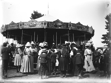
Negative - Haeusler Glass Negatives Collection - Merry-go-round - A. Weniger's Steam Carousel
This digital image was produced from one of the glass negatives that form part of the collection, probably taken by Louis Haeusler (b.1887) with the photographic equipment in the Wodonga Historical Society Haeusler Collection. Merry-Go-Rounds or Carousels were a popular entertainment accompanying many celebrations and events in Albury and Wodonga from as early as the mid 1870s. They featured at events such as Empire Day and Arbor Day celebrations as well as the Wodonga Racing Club meetings, Wodonga Agricultural Shows and Victory Day celebrations at the end of World War 11. They were operated by a variety of travelling showmen and entrepreneurs. Early merry-go-rounds were steam powered. The merry-go-round in this negative was owned by Anton Weniger of Melbourne. From 1909, Mr Weniger operated a shooting gallery and Steam Riding Gallery on the Lower Esplanade, St. Kilda on land he had leased in 1909 from the St. Kilda Foreshore Trust. Weniger also took his carousels by train to many rural areas, including several visits to Albury, Yarrawonga and Benalla. His largest carousel was designed and built in Melbourne by Herbert Thomson in 1915. It has now been restored and has been on show as the Civic Carousel in Canberra, ACT since 1974. Anton Weniger’s steam merry-go-round was definitely in the Albury- Wodonga area in September 1912. As reported in the Border Morning Mail on Saturday 2 November 1912, Mr. Weniger was the victim of a robbery which included some money and his gold watch and chain, stolen from a railway truck in the Wodonga railway yards. The riding gallery and other belongings had been placed on the truck in Albury after the Albury show and sent on to Wodonga in transit to Wangaratta. Whilst in the Wodonga yards the truck was broken into and the goods stolen. Two of Weniger’s former employees, Herbert Backhouse and Edmund Pressard were subsequently charged with the robbery and sentenced to respective sentences of 3 and 9 months imprisonment, both with hard labour. In January 1916, Weniger’s Steam Riding Gallery was attacked by a group of rioting soldiers as a result of rising anti-German sentiment with the onset of World War 1. As a result, Anton Weniger terminated his interest and lease of the Steam Riding Gallery to his partner, William George Kelly. Although he had lived in Victoria for over 25 years and had been a naturalised Australian for 20 years, Anton Weniger was interned for the duration of World War 1 as an enemy alien. Anton Johannes Matthias Weniger died on 14 August 1923 and is buried in the Brighton General Cemetery, Melbourne, Victoria.This item is unique and has well documented provenance and a known owner. It forms part of a significant and representative historical collection which reflects the local history of Wodonga. It contributes to our understanding of domestic and family life in early twentieth century Wodonga, as well as providing interpretative capacity for themes including local history and social history.Digital image created from the Haeusler Glass negative collection. A large group of people standing around a Merry-Go-Round.At top left of Merry-Go-Round "A.WENIGER./MELBOURNE"wodonga pioneers, haeusler family, glass negatives, dry plate photography, carousel, anton weniger -
 Wodonga & District Historical Society Inc
Photograph - Fred Rochow Railways Collection - David Naldrett and Rex McDonnell, 1982
The Fred Rochow Railways Collection incorporates photos related to the operation of the Wodonga Railway Station including different types of trains and railways staff C. 1930 – 1990. It was donated to the Wodonga Historical Society by Fred Rochow, a railwayman who spent many years based in Wodonga. He joined the Victorian Railways on 17th June l947 and retired in 1988. For some time, he was a member of the Australian Federated Union of Locomotive Enginemen and served a term as a member of the Trades Hall Council. He had an extensive knowledge of the struggles that took place to achieve better conditions for railway workers. Fred worked for many years as a fireman and then worked his way up the ranks to driver, experiencing many changes from the days of steam locomotives through to diesel trains, locomotives and even the modern XPT train. He worked throughout Victoria at different stages of his career, with his final working years focused on the northeast of Victoria and the Albury to Melbourne line. After his retirement, Fred continued to share his love of steam miniature trains with the community. The first railway union in the world was created in Melbourne in 1861 when twenty locomotive drivers banded together to form the Locomotive Engine Drivers Association of Victoria. The forerunner to the A.F.U.L.E., the Association continues today and is the oldest continuous railway union in the world.This collection has local and statewide significance as it captures images of trains, locomotives and personnel who operated the railway services in Wodonga and throughout Northeast Victoria. The railways played a critical role in opening up Victoria and connecting Australia for trade, business, social communication and transport.A photo of David Naldrett, AFULE Chairman and Rex McDonnell, Branch Secretary, conducting a meeting in Wodonga in 1982. AFULE is the Australian Federated Union of Locomotive Employees.railways wodonga, fred rochow, afule, railways workers unions -
 Wodonga & District Historical Society Inc
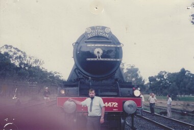
Photograph - Fred Rochow Railways Collection - Crew on the Flying Scotsman, 1988
The Fred Rochow Railways Collection incorporates photos related to the operation of the Wodonga Railway Station including different types of trains and railways staff C. 1930 – 1990. It was donated to the Wodonga Historical Society by Fred Rochow, a railwayman who spent many years based in Wodonga. He joined the Victorian Railways on 17th June l947 and retired in 1988. For some time, he was a member of the Australian Federated Union of Locomotive Enginemen and served a term as a member of the Trades Hall Council. He had an extensive knowledge of the struggles that took place to achieve better conditions for railway workers. Fred worked for many years as a fireman and then worked his way up the ranks to driver, experiencing many changes from the days of steam locomotives through to diesel trains, locomotives and even the modern XPT train. He worked throughout Victoria at different stages of his career, with his final working years focused on the northeast of Victoria and the Albury to Melbourne line. After his retirement, Fred continued to share his love of steam miniature trains with the community.This collection has local and statewide significance as it captures images of trains, locomotives and personnel who operated the railway services in Wodonga and throughout Northeast Victoria. The railways played a critical role in opening up Victoria and connecting Australia for trade, business, social communication and transport.The 4 members of the crew of The Flying Scotsman in 1988, taken at the Albury Station The Flying Scotsman Pacific 4-6-2, perhaps one of the most iconic steam locomotives in the world, visited Australia in 1988-89 for a series of events associated with the country’s bicentennial celebrations. As part of the Bicentennial celebrations locomotives began to arrive in Melbourne for the AusSteam 88 exhibition from 14 October. A planned parallel run south of Seymour with NSW locomotives 3112 and 1210 and Victorian Railways J515 had to be abandoned due to late running by the NSW locomotives. A parallel run did take place on Sunday 16 October when VR R761 and NSW 3801 ran from Wodonga to Melbourne. On 25 October 1988, the Flying Scotsman worked its first passenger trip in Australia when it took a return Melbourne to Albury journey. L-R: Guard Jim Taylor, Fireman Noel Strauss, Foreman Jack Brown and Driver Ned Ziebell.railways wodonga, fred rochow, flying scotsman, australia bicentennial -
 Wodonga & District Historical Society Inc
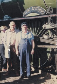
Photograph - Fred Rochow Railways Collection - Guard Colin Ray and The Flying Scotsman, 1988
The Fred Rochow Railways Collection incorporates photos related to the operation of the Wodonga Railway Station including different types of trains and railways staff C. 1930 – 1990. It was donated to the Wodonga Historical Society by Fred Rochow, a railwayman who spent many years based in Wodonga. He joined the Victorian Railways on 17th June l947 and retired in 1988. For some time, he was a member of the Australian Federated Union of Locomotive Enginemen and served a term as a member of the Trades Hall Council. He had an extensive knowledge of the struggles that took place to achieve better conditions for railway workers. Fred worked for many years as a fireman and then worked his way up the ranks to driver, experiencing many changes from the days of steam locomotives through to diesel trains, locomotives and even the modern XPT train. He worked throughout Victoria at different stages of his career, with his final working years focused on the northeast of Victoria and the Albury to Melbourne line. After his retirement, Fred continued to share his love of steam miniature trains with the community.This collection has local and statewide significance as it captures images of trains, locomotives and personnel who operated the railway services in Wodonga and throughout Northeast Victoria. The railways played a critical role in opening up Victoria and connecting Australia for trade, business, social communication and transport.Guard Colin Ray standing in front of The Flying Scotsman at Longwood, Victoria on 20th October 1988. The Flying Scotsman Pacific 4-6-2, perhaps one of the most iconic steam locomotives in the world, visited Australia in 1988-89 for a series of events associated with the country’s bicentennial celebrations. As part of the Bicentennial celebrations locomotives began to arrive in Melbourne for the AusSteam 88 exhibition from 14 October. A planned parallel run south of Seymour with NSW locomotives 3112 and 1210 and Victorian Railways J515 had to be abandoned due to late running by the NSW locomotives. A parallel run did take place on Sunday 16 October when VR R761 and NSW 3801 ran from Wodonga to Melbourne. On 25 October 1988, the Flying Scotsman worked its first passenger trip in Australia when it took a return Melbourne to Albury journey. L-R: Guard Jim Taylor, Fireman Noel Strauss, Foreman Jack Brown and Driver Ned Ziebell.railways wodonga, fred rochow, flying scotsman -
 Wodonga & District Historical Society Inc
Photograph - Fred Rochow Railways Collection - Driver Len Gregson and Fireman-Driver Noel Strauss, 1988
The Fred Rochow Railways Collection incorporates photos related to the operation of the Wodonga Railway Station including different types of trains and railways staff C. 1930 – 1990. It was donated to the Wodonga Historical Society by Fred Rochow, a railwayman who spent many years based in Wodonga. He joined the Victorian Railways on 17th June l947 and retired in 1988. For some time, he was a member of the Australian Federated Union of Locomotive Enginemen and served a term as a member of the Trades Hall Council. He had an extensive knowledge of the struggles that took place to achieve better conditions for railway workers. Fred worked for many years as a fireman and then worked his way up the ranks to driver, experiencing many changes from the days of steam locomotives through to diesel trains, locomotives and even the modern XPT train. He worked throughout Victoria at different stages of his career, with his final working years focused on the northeast of Victoria and the Albury to Melbourne line. After his retirement, Fred continued to share his love of steam miniature trains with the community.This collection has local and statewide significance as it captures images of trains, locomotives and personnel who operated the railway services in Wodonga and throughout Northeast Victoria. The railways played a critical role in opening up Victoria and connecting Australia for trade, business, social communication and transport.Driver Len Gregson and Fireman-Driver Noel Strauss on The Flying Scotsman receiving instruction from Leading Shunter Hans Rheuben (NSW) on 20 October1988. The Flying Scotsman Pacific 4-6-2, perhaps one of the most iconic steam locomotives in the world, visited Australia in 1988-89 for a series of events associated with the country’s bicentennial celebrations. As part of the Bicentennial celebrations locomotives began to arrive in Melbourne for the AusSteam 88 exhibition from 14 October. A planned parallel run south of Seymour with NSW locomotives 3112 and 1210 and Victorian Railways J515 had to be abandoned due to late running by the NSW locomotives. A parallel run did take place on Sunday 16 October when VR R761 and NSW 3801 ran from Wodonga to Melbourne. On 25 October 1988, the Flying Scotsman worked its first passenger trip in Australia when it took a return Melbourne to Albury journey.railways wodonga, fred rochow, flying scotsman, australia bicentennial -
 Wodonga & District Historical Society Inc
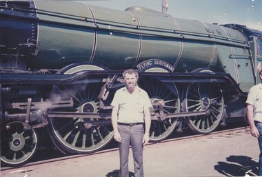
Photograph - Fred Rochow Railways Collection - Engine Instructor Jack Brown and Driver Fred Rochow, 1988
The Fred Rochow Railways Collection incorporates photos related to the operation of the Wodonga Railway Station including different types of trains and railways staff C. 1930 – 1990. It was donated to the Wodonga Historical Society by Fred Rochow, a railwayman who spent many years based in Wodonga. He joined the Victorian Railways on 17th June l947 and retired in 1988. For some time, he was a member of the Australian Federated Union of Locomotive Enginemen and served a term as a member of the Trades Hall Council. He had an extensive knowledge of the struggles that took place to achieve better conditions for railway workers. Fred worked for many years as a fireman and then worked his way up the ranks to driver, experiencing many changes from the days of steam locomotives through to diesel trains, locomotives and even the modern XPT train. He worked throughout Victoria at different stages of his career, with his final working years focused on the northeast of Victoria and the Albury to Melbourne line. After his retirement, Fred continued to share his love of steam miniature trains with the community.This collection has local and statewide significance as it captures images of trains, locomotives and personnel who operated the railway services in Wodonga and throughout Northeast Victoria. The railways played a critical role in opening up Victoria and connecting Australia for trade, business, social communication and transport.Engine Instructor Jack Brown and Driver Fred Rochow standing in front of The Flying Scotsman in Albury on 25 October1988. The Flying Scotsman Pacific 4-6-2, perhaps one of the most iconic steam locomotives in the world, visited Australia in 1988-89 for a series of events associated with the country’s bicentennial celebrations. As part of the Bicentennial celebrations locomotives began to arrive in Melbourne for the AusSteam 88 exhibition from 14 October. A planned parallel run south of Seymour with NSW locomotives 3112 and 1210 and Victorian Railways J515 had to be abandoned due to late running by the NSW locomotives. A parallel run did take place on Sunday 16 October when VR R761 and NSW 3801 ran from Wodonga to Melbourne. On 25 October 1988, the Flying Scotsman worked its first passenger trip in Australia when it took a return Melbourne to Albury journey. On insignia on the side of locomotive "FLYING SCOTSMAN"railways wodonga, fred rochow, flying scotsman, railways albury, australia bicentennial -
 Wodonga & District Historical Society Inc
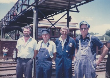
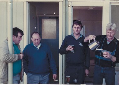
Photograph - Fred Rochow Railways Collection - Group of 4 men in Wodonga
The Fred Rochow Railways Collection incorporates photos related to the operation of the Wodonga Railway Station including different types of trains and railways staff C. 1930 – 1990. It was donated to the Wodonga Historical Society by Fred Rochow, a railwayman who spent many years based in Wodonga. He joined the Victorian Railways on 17th June l947 and retired in 1988. For some time, he was a member of the Australian Federated Union of Locomotive Enginemen and served a term as a member of the Trades Hall Council. He had an extensive knowledge of the struggles that took place to achieve better conditions for railway workers. Fred worked for many years as a fireman and then worked his way up the ranks to driver, experiencing many changes from the days of steam locomotives through to diesel trains, locomotives and even the modern XPT train. He worked throughout Victoria at different stages of his career, with his final working years focused on the northeast of Victoria and the Albury to Melbourne line. After his retirement, Fred continued to share his love of steam miniature trains with the community The first railway union in the world was created in Melbourne in 1861 when twenty locomotive drivers banded together to form the Locomotive Engine Drivers Association of Victoria. The forerunner to the A.F.U.L.E., the Association continues today and is the oldest continuous railway union in the world. A.R.U. - The Australian Railways Union formed in September 1920 with the amalgamation of the Queensland Railways Union, the New South Wales Amalgamated Railway and Tramway Service Association, the Victorian Railway Union, the Railway and Tramway Employees Association of South Australia and the Tasmanian Railway Union. It was the first Australian all-grades organisation of railway workers and was federally registered on 8 February 1921. In 1993 the ARU merged with other unions to form the Rail Tram & Bus Industry Union.This collection has local and statewide significance as it captures images of trains, locomotives and personnel who operated the railway services in Wodonga and throughout Northeast Victoria. The railways played a critical role in opening up Victoria and connecting Australia for trade, business, social communication and transport.A group 4 men in Wodonga. Possibly at branch union meeting.Left to right: Driver R. Heathcote AFULE Branch Secretary; Guard J. Young, ARU Branch Secretary; Driver S. Withers; P. Murnane.fred rochow, victorian railways wodonga, railway employees wodonga, railway trade unions -
 Wodonga & District Historical Society Inc
Photograph - Fred Rochow Railways Collection - Jimmy Taylor, 1988
The Fred Rochow Railways Collection incorporates photos related to the operation of the Wodonga Railway Station including different types of trains and railways staff C. 1930 – 1990. It was donated to the Wodonga Historical Society by Fred Rochow, a railwayman who spent many years based in Wodonga. He joined the Victorian Railways on 17th June l947 and retired in 1988. For some time, he was a member of the Australian Federated Union of Locomotive Enginemen and served a term as a member of the Trades Hall Council. He had an extensive knowledge of the struggles that took place to achieve better conditions for railway workers. Fred worked for many years as a fireman and then worked his way up the ranks to driver, experiencing many changes from the days of steam locomotives through to diesel trains, locomotives and even the modern XPT train. He worked throughout Victoria at different stages of his career, with his final working years focused on the northeast of Victoria and the Albury to Melbourne line. After his retirement, Fred continued to share his love of steam miniature trains with the community. The Flying Scotsman Pacific 4-6-2, perhaps one of the most iconic steam locomotives in the world, visited Australia in 1988-89 for a series of events associated with the country’s bicentennial celebrations. As part of the celebrations locomotives began to arrive in Melbourne for the exhibition from 14 October. A planned parallel run south of Seymour with NSW locomotives 3112 and 1210 and Victorian Railways J515 had to be abandoned due to late running by the NSW locomotives. A parallel run did take place on Sunday 16 October when VR R761 and NSW 3801 ran from Wodonga to Melbourne. On 25 October, the Flying Scotsman worked its first passenger trip in Australia when it took a return Melbourne to Albury service.This collection has local and statewide significance as it captures images of trains, locomotives and personnel who operated the railway services in Wodonga and throughout Northeast Victoria. The railways played a critical role in opening up Victoria and connecting Australia for trade, business, social communication and transport.Jimmy Taylor standing beside the Flying Scotsman. He was a Guard on the locomotive in 1988 during the Australian Bicentennial visit. On the side of the locomotive "FLYING SCOTSMAN"railways wodonga, fred rochow, jimmy taylor, flying scotsman -
 Wodonga & District Historical Society Inc
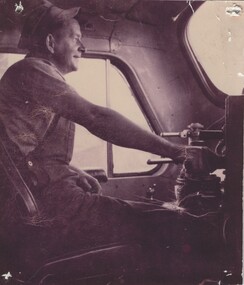
Photograph - Fred Rochow Railways Collection - Len Gregson Driver, 1988
The Fred Rochow Railways Collection incorporates photos related to the operation of the Wodonga Railway Station including different types of trains and railways staff C. 1930 – 1990. It was donated to the Wodonga Historical Society by Fred Rochow, a railwayman who spent many years based in Wodonga. He joined the Victorian Railways on 17th June l947 and retired in 1988. For some time, he was a member of the Australian Federated Union of Locomotive Enginemen and served a term as a member of the Trades Hall Council. He had an extensive knowledge of the struggles that took place to achieve better conditions for railway workers. Fred worked for many years as a fireman and then worked his way up the ranks to driver, experiencing many changes from the days of steam locomotives through to diesel trains, locomotives and even the modern XPT train. He worked throughout Victoria at different stages of his career, with his final working years focused on the northeast of Victoria and the Albury to Melbourne line. After his retirement, Fred continued to share his love of steam miniature trains with the community. The Flying Scotsman Pacific 4-6-2, perhaps one of the most iconic steam locomotives in the world, visited Australia in 1988-89 for a series of events associated with the country’s bicentennial celebrations. As part of the celebrations locomotives began to arrive in Melbourne for the exhibition from 14 October. A planned parallel run south of Seymour with NSW locomotives 3112 and 1210 and Victorian Railways J515 had to be abandoned due to late running by the NSW locomotives. A parallel run did take place on Sunday 16 October when VR R761 and NSW 3801 ran from Wodonga to Melbourne. On 25 October, the Flying Scotsman worked its first passenger trip in Australia when it took a return Melbourne to Albury service.This collection has local and statewide significance as it captures images of trains, locomotives and personnel who operated the railway services in Wodonga and throughout Northeast Victoria. The railways played a critical role in opening up Victoria and connecting Australia for trade, business, social communication and transport.Len Gregson at the controls. He was the Driver of the Flying Scotsman's first Victorian run in 1988.railways wodonga, fred rochow, jimmy taylor, flying scotsman -
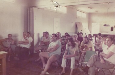 Wodonga & District Historical Society Inc
Photograph - Fred Rochow Railways Collection - Members at A.F.U.L.E meeting in Wodonga
The Fred Rochow Railways Collection incorporates photos related to the operation of the Wodonga Railway Station including different types of trains and railways staff C. 1930 – 1990. It was donated to the Wodonga Historical Society by Fred Rochow, a railwayman who spent many years based in Wodonga. He joined the Victorian Railways on 17th June l947 and retired in 1988. For some time, he was a member of the Australian Federated Union of Locomotive Enginemen and served a term as a member of the Trades Hall Council. He had an extensive knowledge of the struggles that took place to achieve better conditions for railway workers. Fred worked for many years as a fireman and then worked his way up the ranks to driver, experiencing many changes from the days of steam locomotives through to diesel trains, locomotives and even the modern XPT train. He worked throughout Victoria at different stages of his career, with his final working years focused on the northeast of Victoria and the Albury to Melbourne line. After his retirement, Fred continued to share his love of steam miniature trains with the community The first railway union in the world was created in Melbourne in 1861 when twenty locomotive drivers banded together to form the Locomotive Engine Drivers Association of Victoria. The forerunner to the A.F.U.L.E., the Association continues today and is the oldest continuous railway union in the world.This collection has local and statewide significance as it captures images of trains, locomotives and personnel who operated the railway services in Wodonga and throughout Northeast Victoria. The railways played a critical role in opening up Victoria and connecting Australia for trade, business, social communication and transport.A group members at a branch meeting of the A.F.U.L.E in Wodonga.Left to right: Mick Bergin, Mick Seymour, Mick O’Brien, Les Hallawell, John Wortman, John Hickey, Fred Rochow, Kevin Hammond, Ray Newton, Paul Hines, Peter Murnane, Paul Byrne, Keith Porter, Benny Hill, Mick Mathews, Keith Moore.fred rochow, victorian railways wodonga, railway employees wodonga, railway trade unions, australian federated union of locomotive enginemen -
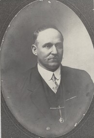 Wodonga & District Historical Society Inc
Photograph - Fred Rochow Railways Collection - John Bennet Bruce, Victorian Railways
The Fred Rochow Railways Collection incorporates photos related to the operation of the Wodonga Railway Station including different types of trains and railways staff C. 1930 – 1990. It was donated to the Wodonga Historical Society by Fred Rochow, a railwayman who spent many years based in Wodonga. He joined the Victorian Railways on 17th June l947 and retired in 1988. For some time, he was a member of the Australian Federated Union of Locomotive Enginemen and served a term as a member of the Trades Hall Council. He had an extensive knowledge of the struggles that took place to achieve better conditions for railway workers. Fred worked for many years as a fireman and then worked his way up the ranks to driver, experiencing many changes from the days of steam locomotives through to diesel trains, locomotives and even the modern XPT train. He worked throughout Victoria at different stages of his career, with his final working years focused on the northeast of Victoria and the Albury to Melbourne line. After his retirement, Fred continued to share his love of steam miniature trains with the community. Locomotive Engine Drivers and Firemen’s Association - The first railway union in the world was created in Melbourne in 1861 with the formation of the Locomotive Engine Drivers Association of Victoria. The Association was formed seven years after the official opening of Victoria’s first railway line in 1854. In 1872, the association expanded to include firemen. The name of the association became the Locomotive Engine Drivers and Firemen’s Association to reflect the change in constitution. Over time this Association amalgamated with organisations in other states and eventually became the Australian Federated Union of Locomotive Employees which still operates today.This collection has local and statewide significance as it captures images of trains, locomotives and personnel who operated the railway services in Wodonga and throughout Northeast Victoria. The railways played a critical role in opening up Victoria and connecting Australia for trade, business, social communication and transport. A portrait of John Bennet Bruce. He was born on 8 February 1865. John started his railway career in North Melbourne on 13T February 1885. He achieved his driving certification in North Melbourne on 24 December 1899. John became President of the North Melbourne branch of in 1910. He transferred to Wodonga in 4 September 1914.railways wodonga, fred rochow, john bennet bruce, locomotive engine drivers and firemen’s association -
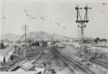 Wodonga & District Historical Society Inc
Photograph - Fred Rochow Railways Collection - Walker Railmotor, C. 1950
The Fred Rochow Railways Collection incorporates photos related to the operation of the Wodonga Railway Station including different types of trains and railways staff C. 1930 – 1990. It was donated to the Wodonga Historical Society by Fred Rochow, a railwayman who spent many years based in Wodonga. He joined the Victorian Railways on 17th June l947 and retired in 1988. For some time, he was a member of the Australian Federated Union of Locomotive Enginemen and served a term as a member of the Trades Hall Council. He had an extensive knowledge of the struggles that took place to achieve better conditions for railway workers. Fred worked for many years as a fireman and then worked his way up the ranks to driver, experiencing many changes from the days of steam locomotives through to diesel trains, locomotives and even the modern XPT train. He worked throughout Victoria at different stages of his career, with his final working years focused on the northeast of Victoria and the Albury to Melbourne line. After his retirement, Fred continued to share his love of steam miniature trains with the community.This collection has local and statewide significance as it captures images of trains, locomotives and personnel who operated the railway services in Wodonga and throughout Northeast Victoria. The railways played a critical role in opening up Victoria and connecting Australia for trade, business, social communication and transport.Walker rail motors were a type of diesel railcar operated by the Victorian Railways. After World War 11, the Victorian Railways undertook a major rebuilding program known as Operation Phoenix. One of the first tasks was the upgrading of passenger services on country branch lines. An initial order of twelve 102 HP railcars, six 153 HP railcars with trailers, and twelve 280 HP railcars was placed with Walker Brothers, England. The power units were manufactured in England, but the units were assembled in Victoria. The first rail motors were delivered in 1948, with additions to the fleet running through to 1955. According to a Victoria Railways Memorandum issued on 24 May 1949, regarding the allocation of the new 102 HP Walker Diesel Motor Rail Vehicles, No 10 was to be allocated to the Wodonga to Tallangatta line as soon as it was available. No 10 entered service on 22 November 1949. The passenger rail motors had room for 18 First class and 22 Second class seated passengers. The last passenger service from Wodonga to Tallangatta ran on 30 September 1961 with a 102hp Walker Rail Motor.railways wodonga, fred rochow, walker rail motor vehicles, wodonga to tallangatta rail service -
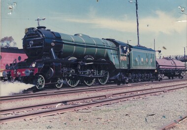 Wodonga & District Historical Society Inc
Photograph - Fred Rochow Railways Collection - "The Flying Scotsman" with water gin, 25 October 1988
The Fred Rochow Railways Collection incorporates photos related to the operation of the Wodonga Railway Station including different types of trains and railways staff C. 1930 – 1990. It was donated to the Wodonga Historical Society by Fred Rochow, a railwayman who spent many years based in Wodonga. He joined the Victorian Railways on 17th June l947 and retired in 1988. For some time, he was a member of the Australian Federated Union of Locomotive Enginemen and served a term as a member of the Trades Hall Council. He had an extensive knowledge of the struggles that took place to achieve better conditions for railway workers. Fred worked for many years as a fireman and then worked his way up the ranks to driver, experiencing many changes from the days of steam locomotives through to diesel trains, locomotives and even the modern XPT train. He worked throughout Victoria at different stages of his career, with his final working years focused on the northeast of Victoria and the Albury to Melbourne line. After his retirement, Fred continued to share his love of steam miniature trains with the community.This collection has local and statewide significance as it captures images of trains, locomotives and personnel who operated the railway services in Wodonga and throughout Northeast Victoria. The railways played a critical role in opening up Victoria and connecting Australia for trade, business, social communication and transport."The Flying Scotsman" locomotive with water gin behind at the Albury Station. The Flying Scotsman Pacific 4-6-2, perhaps one of the most iconic steam locomotives in the world, visited Australia in 1988-89 for a series of events associated with the country’s bicentennial celebrations. As part of the Bicentennial celebrations locomotives began to arrive in Melbourne for the AusSteam 88 exhibition from 14 October. A planned parallel run south of Seymour with NSW locomotives 3112 and 1210 and Victorian Railways J515 had to be abandoned due to late running by the NSW locomotives. A parallel run did take place on Sunday 16 October when VR R761 and NSW 3801 ran from Wodonga to Melbourne. On 25 October 1988, the Flying Scotsman worked its first passenger trip in Australia when it took a return Melbourne to Albury journey.railways wodonga, fred rochow, flying scotsman, australia bicentennial