Showing 1625 items
matching yarra river
-
 Eltham District Historical Society Inc
Photograph, Yarra River from Henley Bridge, Kangaroo Ground, Spring Excursion, Exploring the Upper Yarra, 22 October 1995, 22/10/1995
... Yarra River from Henley Bridge, Kangaroo Ground, Spring... to glimpse the Yarra River, upstream and down, its secret places... to glimpse the Yarra River, upstream and down, its secret places ...[article by Bettina Woodburn in EDHS Newsletter No. 105, November 1995:] EXPLORING THE UPPER YARRA - We enjoyed the Spring Excursion, this year "Exploring the Upper Yarra" - in spite of the constant rain and the countryside under the cloud cover, especially in the valleys, being mainly shiny shades of green. The occasional fields of buttercups, clumps of arum lilies and splendid rhododendron and other flowering bushes became very special. The Cobb and Co coach was warm and a cosy retreat as we zig-zagged on the highways and byways to glimpse the Yarra River, upstream and down, its secret places, and particularly the many bridges. Russell excelled as 'Poet Laureate', reading from Dacre Smyth's book. This 1979 publication includes paintings of all the bridges along the river with poems and brief descriptions of each one. Some of the bridges are in out-of-the-way places and are not very well known. We looked forward to hearing the poetry as much as seeing the 'constructions'… Big Pat (was he short or tall, lean or fat? - he did win the £200 reward for discovering gold and had the creek named after him), about the 'Eddies'?, and the disliked 'meccano' bridge in Warburton, etc. etc. The hot roast lunch in the old Reefton Hotel was also most welcome. It was easy to imagine it peopled by miners and early settlers. Starting by crossing the new (1974) concrete bridge at Warrandyte we headed through Wonga Park with views to the Christmas Hills and to the escarpment of the Yering Gorge, which causes flood waters to back up through the Yarra Glen plain, so avoiding disasters downstream. At the end of a long driveway we found the wooden, privately owned Henley Bridge (1935 after the 1934 floods). This facilitates access to different parts of Henley Farm and to Lilydale. Everard Park, named after Blanche Shallard's father, a State Member for 17 years, below the Highway Yarra crossing was in need of care. It is 10 miles from Yarra Glen by road but, as "Yarra Marra” canoeists well know, 32 winding miles down by water. After more delightful countryside scenes we joined the Warburton Highway at Woori Yallock. From the old Railway Station at Launching Place the Centennial Trail for walkers, cyclists and horse riders has replaced the rails. The line from Lilydale was opened in 1901, and the last diesel freight train ran to Warburton in 1965. It continued to rain as we had morning tea in Warburton in a shelter between footbridges. From here we continued upstream past the Bridge to O'Shannassy Lodge and Reservoir, Starvation Creek, and the Peninsular tunnel (miners dug it as at Pound Bend) which we visited (scrambling down those steps!) on our return after lunch. Our furthermost point was the Upper Yarra Dam Reserve (and vast catchment area). Finished in 1957 after ten years' work and 100 years after Yan Yean, it supplies much of Melbourne's water. After crossing the 30m Launching Place Bridge to the Eltham side of the Yarra and Healesville, we saw in the distance the Yarra Glen Timber Trestle Bridge over the river flats "the longest for years in the land it was said!" Harry's dream of "better weather over the Divide" unfortunately didn't come true, but I'm sure we 36 members will retain happy memories of a day that was wet and green and filled with Bridges.Colour photographactivities, upper yarra, henley bridge -
![Wal Ives & Bert [Watson] at the outlet of the Kew Main Drain](/media/collectors/550653872162f11fb04854aa/items/61593ef27608a87f688412b1/item-media/61594a5a7608a87f68848c29/item-fit-380x285.jpg) Kew Historical Society Inc
Kew Historical Society IncPhotograph - Wal Ives & Bert [Watson] at the outlet of the Kew Main Drain, c.1900
... yarra river -- kew (vic.)... Kew, both of which empty into the Yarra River. Connor's Creek... was the outlet for Connor's Creek near the Yarra River. The retaining..., both of which empty into the Yarra River. Connor's Creek ...Connor's Creek is/was one of two major waterways bisecting Kew, both of which empty into the Yarra River. Connor's Creek originates near the grounds of Genazzano FCJ College, which is one of the highest points in Kew. Until the 1930s, this was an open creek until a barrel drain - the Kew Main Drain - was constructed. As the creek ran through Kew it cut across a number of roads the maintenance of which was a continuing concern for Kew Councillors. In August 1864, the Council called for tenders to erect a stone culvert and embankment over Connor's Creek, on Belford-road. This may be the embankment on which the boys are sitting.Original, small photographic positive on card of two boys, identified by the donor as 'Wal Ives and Bert' [Albert Watson] sitting on bluestone capping above an outlet of Connor's Creek. To the left of the boys is a barrel drain which at that stage was the outlet for Connor's Creek near the Yarra River. The retaining wall is constructed of brick. In ink on photo: "Wal & Bert"connors creek -- kew (vic), wal ives, albert watson, belford road, yarra river -- kew (vic.), creeks -- kew (vic.), drains -- kew (vic.) -
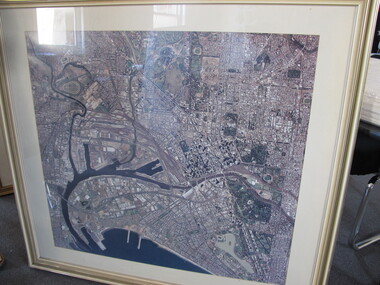 Mission to Seafarers Victoria
Photograph - Aerial Photograph, 1980-1997
... yarra river... of the Yarra river and Docklands, C - 1982 - 1995 .... docklands melbourne aerial view yarra river city port melbourne ...Aerial view of Melbourne pre October 1997 as the Docklands stadium, landmark of the new precinct is not yet built.Large framed and glazed print of aerial colour photograph of the Yarra river and Docklands, C - 1982 - 1995 docklands, melbourne, aerial view, yarra river, city, port melbourne, albert park -
 Eltham District Historical Society Inc
Photograph, Sweeneys Lane looking southwest, Dec 1984, 198412
... yarra river... and Yarra River, Sweeneys Lane, Eltham... melbourne sweeneys lane yarra river eltham thomas sweeney culla hill ...Two colour photographs of view south across Sweeneys flats and Yarra River, Sweeneys Lane, Elthamsweeneys lane, yarra river, eltham, thomas sweeney, culla hill -
 Kew Historical Society Inc
Photograph, Chipperfield's Boat House & Floating Pontoon, c.1939
... river yarra... floods, and in 1934 almost totally submerged when the Yarra River...) on the Yarra River. at North Kew The children wading in the river... almost totally submerged when the Yarra River rose 26 feet in 14 ...Several boathouses were built in Kew and Fairfield in the late 19th and early 20th centuries. They included Chipperfield’s ‘Moorings’ and floating pontoon. The substantial two-storey house was named the Moorings, and incorporated an upper storey residence. The Moorings was almost washed away in the 1916 floods, and in 1934 almost totally submerged when the Yarra River rose 26 feet in 14 hours. Following the 1934 flood, the house was restored. The floating pontoon, sometimes referred to as a ‘kiosk’ or ‘canteen’, was used to store canoes. Both were removed in 1972 for the construction of the Eastern Freeway.This work forms part of the collection assembled by the historian Dorothy Rogers, that was donated to the Kew Historical Society by her son John Rogers in 2015. The manuscripts, photographs, maps, and documents were sourced by her from both family and local collections or produced as references for her print publications. Many were directly used by Rogers in writing ‘Lovely Old Homes of Kew’ (1961) and 'A History of Kew' (1973), or the numerous articles on local history that she produced for suburban newspapers. Most of the photographs in the collection include detailed annotations in her hand. The Rogers Collection provides a comprehensive insight into the working habits of a historian in the 1960s and 1970s. Together it forms the largest privately-donated collection within the archives of the Kew Historical Society.Chipperfield's Floating Canteen (also known as the pontoon) on the Yarra River. at North Kew The children wading in the river are believed to be the three sons of Dorothy Rogers."Chipperfield's Floating Canteen & house in background. At extreme right - observe channel where Connors Creek flows in."chipperfield's boat house, river yarra, dorothy rogers, floods 1916, 1934 -
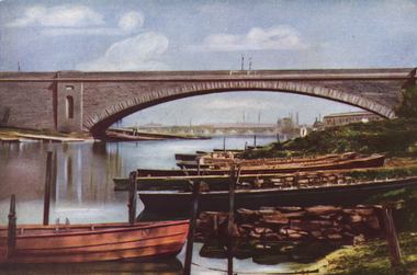 Ballarat Heritage Services
Photograph - Image, The First Prince's Bridge, Melbourne - Later Queen's Bridge, c1951
... yarra river... the Yarra River in Melbourne. It was later known as Queen's Bridge.... Office goldfields princes bridge queen's bridge yarra river ...A colour image of the first Prince's Bridge built across the Yarra River in Melbourne. It was later known as Queen's Bridge.princes bridge, queen's bridge, yarra river, rowboats -
 Yarra Glen & District Historical Society
Sepia postcards, The watering place Yarra Glen
... yarra river... of the bridge over the Yarra River at Yarra Glen. A small herd of cattle...-ranges horse yarra river yarra glen cattle horse and rider river ...Sepia photograph taken from a point just north of the bridge over the Yarra River at Yarra Glen. A small herd of cattle and a horse are on the river bank and in the water. A horse with rider stands on the bank.On back of postcard at the top "POST CARD". On the left hand side "THIS SPACE MAY BE USED FOR PRINTED OR WRITTEN MATTER”. On the right hand side "ONLY THE ADDRESS TO BE WRITTEN HERE”. In a box in the right hand corner "A HALF-PENNY STAMP TO BE PLACED HERE". Along the left hand margin "Ajax series. Printed in England". horse, yarra river, yarra glen, cattle, horse and rider, river -
 Port Melbourne Historical & Preservation Society
Book, Kristin Otto, "Yarra - A Diverting History of Melbourne's Murky River", 2005
... yarra river..."Yarra - A Diverting History of Melbourne's Murky River.... History of Yarra River covering commercial and social uses. "Yarra ..."Yarra - A Diverting History of Melbourne's Murky River" by Kristin Otto. History of Yarra River covering commercial and social uses."To Port Melbourne Historical and Preservation Society, with best riverside wishes. Kristin Otto"yarra river, kirstin otto -
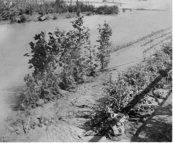 University of Melbourne, Burnley Campus Archives
Photograph - Black and white print, Orchard in Flood, 1934
... yarra river... ? Pipe is showing. Yarra River broke its bank on the night...orchard yarra river floods 1934 Black and white photograph ...Black and white photograph. Orchard in flood: an irrigation ? Pipe is showing. Yarra River broke its bank on the night of 30.11.1934.orchard, yarra river, floods, 1934 -
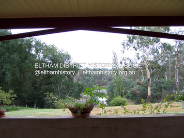 Eltham District Historical Society Inc
Photograph - Digital Photograph, Marguerite Marshall, View of the Yarra River from 'Worlingworth', 10-26 Banoon Road, Eltham, 30 January 2006
... View of the Yarra River from 'Worlingworth', 10-26 Banoon... View of the Yarra River from 'Worlingworth', 10-26 Banoon Road ...'Worlingworth', Eltham, home of noted anthropologist the late Professor Donald Thomson and his wife Dorita Thomson. Covered under Heritage Overlay, Nillumbik Planning Scheme. Published: Nillumbik Now and Then / Marguerite Marshall 2008; photographs Alan King with Marguerite Marshall.; p127This collection of almost 130 photos about places and people within the Shire of Nillumbik, an urban and rural municipality in Melbourne's north, contributes to an understanding of the history of the Shire. Published in 2008 immediately prior to the Black Saturday bushfires of February 7, 2009, it documents sites that were impacted, and in some cases destroyed by the fires. It includes photographs taken especially for the publication, creating a unique time capsule representing the Shire in the early 21st century. It remains the most recent comprehenesive publication devoted to the Shire's history connecting local residents to the past. nillumbik now and then (marshall-king) collection, banoon road, donald thomson, dorita thomson, eltham, worlingworth -
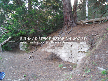 Eltham District Historical Society Inc
Photograph, Fay Bridge, Ruins at Griffith Park, Eltham near the Yarra River, June 2016
... Ruins at Griffith Park, Eltham near the Yarra River... near the Yarra River Photograph Photograph Fay Bridge ...Griffith Park is the former property and home of Cr Fred Griffith in the 1950sfay bridge collection, 2016-06, griffith park, ruins -
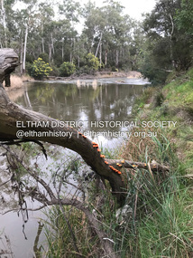 Eltham District Historical Society Inc
Photograph, Fay Bridge, Yarra River near the eastern boundary of former Warrandyte Aboriginal Reserve, North Warrandyte, 11 August 2023
... Yarra River near the eastern boundary of former Warrandyte... Reserve 2023-08-11 1 images - born digital Yarra River near ...Accessed via The Boulevard, North Warrandytefay bridge collection, aboriginal reserve, north warrandyte, warrandyte aboriginal reserve, 2023-08-11 -
 Eltham District Historical Society Inc
Book, D. Pendavingh, Yarra River Trail Plan 1989: Banksia Street to Warrandyte, 1989
... Yarra River Trail Plan 1989: Banksia Street to Warrandyte... loose A3 mylar plan inserted Yarra River Trail Plan 1989 ...Also contains a loose A3 mylar plan inserted - Depart of Planning and Urban Growth, Heidelberg; Main Yarra Trail; Warringal Parklands and Banyule Flats, Detail Plan and Locality Plan -
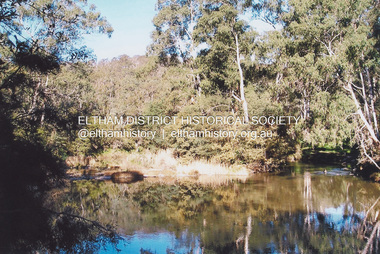 Eltham District Historical Society Inc
Photograph, Fay Bridge, Swimming spot in Yarra River off Laughing Waters Road, Eltham near Caitlin's Retreat, n.d
... Swimming spot in Yarra River off Laughing Waters Road... Swimming Pool 1 image - born digital Swimming spot in Yarra River ...fay bridge collection, caitlin's retreat, laughing waters, swimming pool -
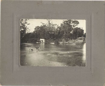
 Greensborough Historical Society
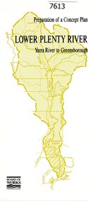
Pamphlet, Melbourne & Metropolitan Board of Works, Lower Plenty River: Yarra River to Greensborough: preparation of a concept plan, 1990
... Lower Plenty River: Yarra River to Greensborough...., illus., tri-fold pamphlet. 2 copies Lower Plenty River: Yarra ...This pamphlet outlines a proposed concept plan for the lower Plenty River, Greensborough to Heidelberg. The plan would focus on preserving and enhancing the aesthetic, recreational and conservation potential of the waterway.2 p., illus., tri-fold pamphlet. 2 copiesplenty river, melbourne water corporation, board of works -
 Greensborough Historical Society
Photograph - Digital image, Outing at Laughing Waters on The Yarra River, 1935, 1935_
... Outing at Laughing Waters on The Yarra River, 1935.... Waters on The Yarra River, 1935. Photograph - Digital image ...Part of a collection of photographs owned by Dorris McLaughlin who was born in Greensborough, in 1899 to John McLaughlin and Rosalie Ellen Whatmough. The collection contains photographs of friends and relatives from the Greensborough and Eltham areas. This photograph shows a large group of people sitting beside the river.Digital copy of black and white photograph.dorris mclaughlin, laughing water -
 Greensborough Historical Society
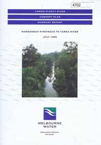
Pamphlet, Lower Plenty River concept plan, summary report: Maroondah Pipetrack to Yarra River, 1992_07
... Pipetrack to Yarra River... River concept plan, summary report: Maroondah Pipetrack to Yarra ...This draft concept plan covers the lower Plenty River from the Maroondah Pipe track in Greensborough to where the Plenty meets the Yarra. Melbourne Water was the lead agency, assisted by the Shires of Eltham and Diamond Valley, City of Heidelberg, the EPA and Department of Planning and Housing.Coloured pamphlet, photograph and plans 12 pages. 2 copies.plenty river, maroondah aqueduct, melbourne water -
 Eltham District Historical Society Inc
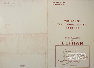
Photograph, For Private Sale in Subdivisions; The Lovely "Laughing Water" Paddock on the Yarra River at Eltham
... Water" Paddock on the Yarra River at Eltham.... "Laughing Water" Paddock on the Yarra River at Eltham. Photograph ...Private sale of the "Laughing Water" paddock in subdivision; 5 river frontages with weatherboard villa on Lot 8; 6 woodland blocks of 5 and 6 acres. Sole Agent: Edward Haughton, 379 Collins Street, Melbourne Location plan and subdivision mapA3 colour photographic print from digital image of sales brochure and A4 reproduction of price listlaughing waters, edward haughton, real estate agent, eltham -
 Eltham District Historical Society Inc
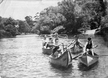
Negative - Photograph, Canoeing on the Yarra River at Warrandyte, Nov. 1934
... Canoeing on the Yarra River at Warrandyte.... in partnership between Eltham District Historical Society and Yarra ...This photo forms part of a collection of photographs gathered by the Shire of Eltham for their centenary project book,"Pioneers and Painters: 100 years of the Shire of Eltham" by Alan Marshall (1971). The collection of over 500 images is held in partnership between Eltham District Historical Society and Yarra Plenty Regional Library (Eltham Library) and is now formally known as the 'The Shire of Eltham Pioneers Photograph Collection.' It is significant in being the first community sourced collection representing the places and people of the Shire's first one hundred years.Digital image 4 x 5 inch B&W Negshire of eltham pioneers photograph collection, warrandyte, canoeing -
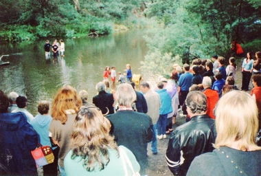 Ringwood and District Historical Society
Photograph, Baptism at Warrandyte in the Yarra River
... Baptism at Warrandyte in the Yarra River.... at Warrandyte in the Yarra River. Photograph ...Conducted by the Truth and Liberation Concern Church. Photo taken by Roy J Mitchell. -
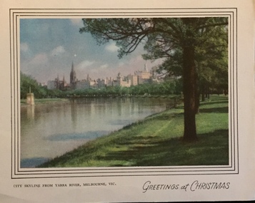 Kew Historical Society Inc
Card, Greetings at Christmas - City skyline from Yarra River Melbourne, 1955-65
... Greetings at Christmas - City skyline from Yarra River... as a greeting card Greetings at Christmas - City skyline from Yarra ...An item from an outstanding and diverse collection, assembled by members of the Christian and Washfold families of Kew.Colour print used as a greeting cardpostcards -- melbourne, christian-washfold collection -
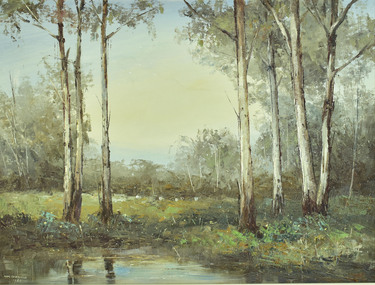 City of Greater Geelong
Oil on Hardboard, Wim Portland, Yarra River
... Yarra River...-and-the-bellarine-peninsula Yarra River Oil on Hardboard Wim Portland ... -
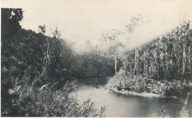 Wonga Park Community Cottage History Group
Photograph (sub-item) - Black and White, ‘Horseshoe Bend’ on the Yarra River at Wonga Park, in 1929
... ‘Horseshoe Bend’ on the Yarra River at Wonga Park, in 1929....’ on the Yarra River at Wonga Park, in 1929. Photograph Black and White ... -
 Wonga Park Community Cottage History Group
Photograph (sub-item) - Black and White, The junction of the Yarra River with Watson’s Creek, on ‘Yarra Brae’ northern boundary in 1940
... The junction of the Yarra River with Watson’s Creek, on..., WONGA PARK, VIC. The junction of the Yarra River with Watson’s ...ROSE SERIES P. CROSSROADS, WONGA PARK, VIC. -
 Wonga Park Community Cottage History Group
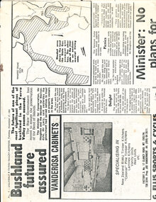
Work on paper - Newspaper cutting, Wonga Park: 17 Nov 1981 Lillydale and Yarra Valley Express: "Bushland future assured" re Acquisition of Yarra River frontage for State Park
... : "Bushland future assured" re Acquisition of Yarra River frontage for... Acquisition of Yarra River frontage for State Park Work on paper ... -
![Photograph (sub-item) - Black and White, A view up the Yarra River from Wonga Park in the 1940’s. [Scouts on Mount Lofty looking upstream] ??](/media/collectors/5c7716e021ea6a1a60039fee/items/63185440823216272c277dad/item-media/63185498823216272c2785f4/item-fit-380x285.jpg) Wonga Park Community Cottage History Group
Wonga Park Community Cottage History GroupPhotograph (sub-item) - Black and White, A view up the Yarra River from Wonga Park in the 1940’s. [Scouts on Mount Lofty looking upstream] ??
... A view up the Yarra River from Wonga Park in the 1940’s... Old Yarra Road Wonga Park melbourne A view up the Yarra River ... -
 Park Orchards Community House
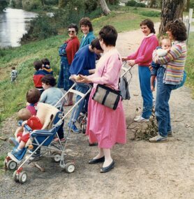
Photograph, Park Orchards Community Centre & Learning Centre Playgroup 1984, strolling with parents along Yarra River
... 1984, strolling with parents along Yarra River... 1984, strolling with parents along Yarra River Photograph ... -
 Port Melbourne Historical & Preservation Society
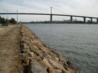
Photograph - West Gate Bridge, Glen Stuart, 6 Oct 2002
... yarra river...Colour photo of West Gate Bridge over Yarra River looking... environment - civic engineering - bridges west gate bridge yarra river ...Colour photo of West Gate Bridge over Yarra River looking west. Shows rock wall to stabilise bank. Fishermens Bendbuilt environment - civic, engineering - bridges, west gate bridge, yarra river -
University of Melbourne, Burnley Campus Archives
Map, Yarra 2500/09.12, c. 1980
... Yarra River... of Works Map Series Yarra 1:2500/ 09.12, showing Yarra River, Kew... of works kew Yarra River Copy of portion of Melbourne ...Copy of portion of Melbourne and Metropolitan Board of Works Map Series Yarra 1:2500/ 09.12, showing Yarra River, Kew area.melbourne and metropolitan board of works, kew, yarra river -
 Kew Historical Society Inc
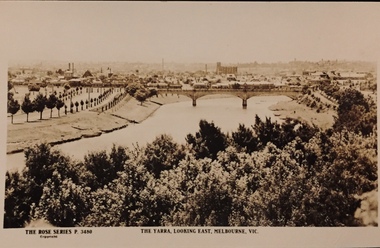
Postcard, Rose Stereograph Company, The Yarra Looking East, Melbourne, Vic
... yarra river -- melbourne... direction along the River Yarra. A State Library of Victoria... and publications donated to the collection in May 2021. yarra river ...One of a number of 'real photo' and commercial postcards created by or owned by members of the Christian and Washfold families of Kew. The postcards are part of a larger collection of photographs, postcards and publications donated to the collection in May 2021.View of Melbourne on the horizon, looking in an easterly direction along the River Yarra. A State Library of Victoria catalogue record says ‘Elevated view along Yarra River, trees in foreground, line of saplings along both banks of the river, bridge in background (possibly Johnson Street Bridge)’. This may be incorrect.The Rose Series P. 3480yarra river -- melbourne, postcards -- yarra river, the rose series postcards, christian-washfold collection