Showing 733 items matching "aerial photo"
-
 Glenelg Shire Council Cultural Collection
Photograph - Photograph - aerial view of Portland, n.d
... Black & white aerial photo of K.S. Anderson wharf area... Portland Harbour K S Anderson Wharf Black & white aerial photo ...Port of Portland Authority Archivesport of portland archives, aerial photography, portland harbour, k s anderson wharf -
Glenelg Shire Council Cultural Collection
Photograph - Photograph - aerial view of Portland, n.d
... Black & white aerial photo of Portland Harbour, taken from... Portland Harbour Black & white aerial photo of Portland Harbour ...Port of Portland Authority Archivesport of portland archives, aerial photography, portland harbour -
Glenelg Shire Council Cultural Collection
Photograph - Photograph - aerial view of Portland, n.d
... Black & white aerial photo of the Port of Portland... Portland Harbour Black & white aerial photo of the Port of Portland ...Port of Portland Authority Archivesport of portland archives, aerial photography, portland harbour -
Glenelg Shire Council Cultural Collection
Photograph - Photograph - Main Breakwater construction, Portland, 17/11/1958
... Black and white aerial photo of the harbour, looking toward... and white aerial photo of the harbour, looking toward main ...Port of Portland Authority ArchivesFront: Purplestamp- '17 Nov 1958' L81-Pencil Back: Purple stamp- '17 Nov 1958' L81 - Pencilport of portland archives, main breakwater, construction, harbour development -
Glenelg Shire Council Cultural Collection
Photograph, n.d
... Black and white aerial photo of Cape Grant quarry... Authority Archives Port of Portland Black and white aerial photo ...Port of Portland Authority Archivesport of portland -
 National Vietnam Veterans Museum (NVVM)
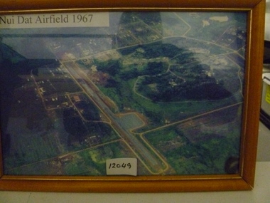
Photograph, Nui Dat Airfield 1967
... Framed coloured aerial photo of Nui Dat Airfield depicting... Photograph Nui Dat Airfield 1962 Framed coloured aerial photo of Nui ...Framed coloured aerial photo of Nui Dat Airfield depicting runway and surrounding infrastructure.Nui Dat Airfield 1962nui dat airfield, photograph -
Whitehorse Historical Society Inc.
Map, Burwood Highway, c1970
... Enlarged aerial photo of area South of Burwood Highway..., Vermont South. Enlarged aerial photo of area South of Burwood ...Enlarged aerial photo of area South of Burwood Highway to Dandenong Creek, Vermont South.Enlarged aerial photo of area South of Burwood Highway to Dandenong Creek, Vermont South.Enlarged aerial photo of area South of Burwood Highway to Dandenong Creek, Vermont South.dandenong creek, morack road, vermont south, burwood highway, vermont south, aerial photographs -
 Bendigo Military Museum
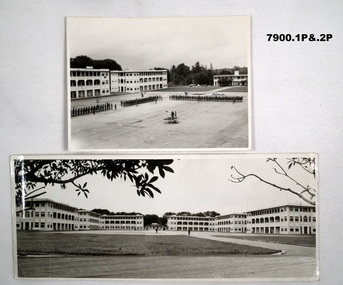
Photograph - SELARANG BARRACKS, 1970
... and buildings of Selarang Base, Singapore in 1970. 3. Aerial photo.... 3. Aerial photo of Selarang Barracks from a distance. 4 ...Various photos of Selarang Barracks in Singapore in 1970. Some aerial and some ground level views. Refer items in Collection of LLoyd Farrell. Refer Cat 7889P.1. Photo of 1 RAR on parade for Trooping of the Colours in 1970 at Selarang Base in Singapore. Covering 'A' 'B' 'C' and Admin Company. 2. Extended portrait photo of the Parade Square and buildings of Selarang Base, Singapore in 1970. 3. Aerial photo of Selarang Barracks from a distance. 4. Aerial photo of Selarang Barracks 1970. 5. Aerial photo of Changi Prison 1970 in Singapore.Written on back. 1. "1 M1+" 2. “Selarang Barracks 1970 occupied by 1st RAR” 4. “Selarang 70” 5. "Changi Prison 1970 Singapore".photograhs, changi, selarang, 1970, lloyd farrell. -
 Tatura Irrigation & Wartime Camps Museum
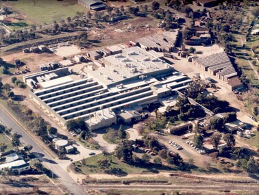
Photograph, Rosella aerial
... Aerial photo of the Unifoods "Rosella" factory at Tatura... Tatura the-murray Aerial photo of the Unifoods "Rosella" factory ...Aerial photo of the Unifoods "Rosella" factory at Tatura, 1997.|Aerial photo of Rosella factory 1949. -
Glenelg Shire Council Cultural Collection
Photograph - Photograph - Cape Grant Quarry, 24/01/1968
... Black and white photo. Aerial photo of Cape Grant quarry.... Aerial photo of Cape Grant quarry from sea, looking north ...Port of Portland Authority ArchivesBack: 'JAN 24, 1968 ' - pencil top rightport of portland archives, cape grant quarry -
Glenelg Shire Council Cultural Collection
Photograph - Photograph - aerial view of Portland Harbour, n.d
... Black & white aerial photo of Portland Harbour, taken from... Blow to 110% -7/101 all in blue biro Black & white aerial photo ...Port of Portland Authority ArchivesBack: Harbour Broad scene P.2 Blow to 110% -7/101 all in blue biroport of portland archives, aerial photography, portland harbour, k s anderson wharf -
Glenelg Shire Council Cultural Collection
Photograph - Photograph - Main Breakwater construction, Portland, n.d
... Black and white aerial photo of land reclamation for main... Portland Harbour Black and white aerial photo of land reclamation ...Port of Portland Authority Archivesport of portland archives, aerial photography, portland harbour -
Glenelg Shire Council Cultural Collection
Photograph - Photograph - Railway Construction, Port of Portland, n.d
... Black and white aerial photo of the Port of Portland... Authority Archives Port of Portland Archives Black and white aerial ...Port of Portland Authority Archivesport of portland archives -
 National Vietnam Veterans Museum (NVVM)
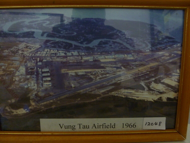
Photograph, Vung Tau Airfield 1966
... Framed coloured aerial photo of Vung Tau airfield depicting... Photograph Vung Tau Airfield -1966 Framed coloured aerial photo ...Framed coloured aerial photo of Vung Tau airfield depicting runway infrastructure and surrounding buildings.Vung Tau Airfield -1966vung tau airfield, photograph -
 Buninyong & District Historical Society
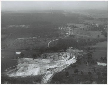
Photograph - Original Photograph, N.L. Harvey and Sons, Ballarat, B/W photo of early site works Mt. Helen Campus of University of Ballarat, 13 May 1968
... B/W aerial photo of early site works Mt. Helen Campus... Photographers 131 Sturt Street Ballarat" B/W aerial photo of early site ...Educational historyB/W aerial photo of early site works Mt. Helen Campus of University of Ballarat.On rear, "Tertiary Institute site work at Mt. Helen commenced March 1968 (see A.R. 1967-68, p.8 Knowles and Stapleton had earthworks contract" also stamp " N.L. Harvey & Son Photographers 131 Sturt Street Ballarat"buninyong, mt. helen, ballarat university, campus, earthworks -
Whitehorse Historical Society Inc.
Map, Husband Road, Forest Hill, 1972
... Enlarged aerial photo of area between Canterbury.... Melbourne, 1972 Enlarged aerial photo of area between Canterbury ...Enlarged aerial photo of area between Canterbury and Husband Roads Forest Hill. Melbourne, 1972Enlarged aerial photo of area between Canterbury and Husband Roads Forest Hill. Melbourne, 1972Enlarged aerial photo of area between Canterbury and Husband Roads Forest Hill. Melbourne, 1972canterbury road, forest hill, husband road, forest hill, hylton crescent, forest hill, sapphire street, forest hill, opal street, forest hill, amber street, forest hill, willurah street, forest hill, nunawading swimming pool, aerial photographs, nunawading memorial swimming pool, nunawading pool, aqualink nunawading -
Port Melbourne Historical & Preservation Society
Photograph - Double-sided aerial photograph, Hobson's Bay and the Yarra River/Port Phillip and Western Port Bay, Surveyor General and Director of Mapping, Apr 1990
... Aerial photos of Port Phillip and Western Port (double... trust - port of melbourne authority Aerial photos of Port ...Landsat imagery - an extract from the atlas of VictoriaAerial photos of Port Phillip and Western Port (double sided aerial photographs), framed and with timber display stand. 1995 side A: Hobson's Bay and Yarra River - aerial photo mosaic; side B. Port Phillip and Western Port Bays - satellite photomelbourne harbor trust - port of melbourne authority -
Glenelg Shire Council Cultural Collection
Photograph - Photograph - aerial view of Portland, n.d
... Black and white aerial photo of Portland Harbour, showing... Harbour Back: harb003 - pencil Black and white aerial photo ...Port of Portland AuthorityBack: harb003 - pencilport of portland archives, aerial photography, portland harbour -
Glenelg Shire Council Cultural Collection
Photograph - Photograph - oil rig, Portland Harbour, n.d
... Black and white aerial photo of Portland Harbour showing... Harbour Back: harb018 - pencil Black and white aerial photo ...Port of Portland Authority ArchivesBack: harb018 - pencilport of portland archives, oil rig, portland harbour -
Glenelg Shire Council Cultural Collection
Photograph - Photograph - aerial view of Portland harbour, n.d
... Black and white aerial photo of Portland Harbour, showing... - blue biro Black and white aerial photo of Portland Harbour ...Port of Portland AuthorityBack: P.12,(iii) black biro 16/17 - black biro 15/1.2 - blue biroport of portland archives, aerial photography, portland harbour -
Glenelg Shire Council Cultural Collection
Photograph - Photograph - Main Breakwater construction, Portland, n.d
... Black and white aerial photo of harbour, looking from main... - '14 Feb 1958' Black and white aerial photo of harbour, looking ...Port of Portland Authority ArchivesFront: Purplestamp-'14 Feb 1958 Back: Purple stamp - '14 Feb 1958'port of portland archives, aerial photography, portland harbour -
Port Melbourne Historical & Preservation Society
Photograph - Aerial view, Fishermen's Bend, 1947
... Aerial photo of Fishermen's Bend with Footscray... fishermans bend footscray Aerial photo of Fishermen's Bend ...Aerial photo of Fishermen's Bend with Footscray in foreground, Maribyrnong River and varous airfields upper left. c1947fishermans bend, footscray -
Whitehorse Historical Society Inc.
Map, Canterbury Road, Vermont, c1970
... Enlarged aerial photo of intersection of Canterbury... Photographs Enlarged aerial photo of intersection of Canterbury ...Enlarged aerial photo of intersection of Canterbury and Boronia Roads. State Aerial Survey, Melbourne 1970 project.Enlarged aerial photo of intersection of Canterbury and Boronia Roads. State Aerial Survey, Melbourne 1970 project.Enlarged aerial photo of intersection of Canterbury and Boronia Roads. State Aerial Survey, Melbourne 1970 project.canterbury road, vermont, boronia road, vermont, mitcham road, vermont, frances avenue, vermont, nurlendi road, vermont, webb court, vermont, vermont primary school, no. 1022, aerial photographs -
 Port Melbourne Historical & Preservation Society
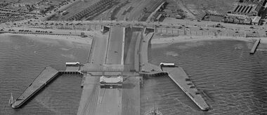
Photograph - Station Pier and surrounds c1940
... Aerial photo approx 1940 showing Station Pier, Centenary... Centenary Bridge Transport - Railways Swallow Street Aerial photo ...It appears that there was some sort of event as there are many pedestrians and many vehicles on Centenary Bridge but very few on the pier. Circa 1940.Aerial photo approx 1940 showing Station Pier, Centenary Bridge, railyards and vehicles on Swallow St. piers and wharves - station pier, centenary bridge, transport - railways, swallow street -
 Greensborough Historical Society
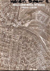
Booklet, Macleod High School 1954-1979, 1979_
... aerial photo of Macleod area...." 20 page booklet. B&W photos. Cover has black and white aerial ...Published to celebrate the silver jubilee of Macleod High School 1954-79, this booklet lists student leaders over 25 years. Photos are included from the 1950s.Documents changes over 25 years at Macleod High School.20 page booklet. B&W photos. Cover has black and white aerial photo of Macleod area.On cover "Helen Spence"macleod high school silver jubilee, macleod high school -
Glenelg Shire Council Cultural Collection
Photograph - Photograph - Cape Grant Quarry, n.d
... Black and white photo aerial photo, looking towards Cape... %' - green pencil, centre Black and white photo aerial photo, looking ...Port of Portland Authority ArchivesBack: 1 cm border ruled around photo in pencil. 'Reduce to 28 ems wide' in pencil, top border. '(15); pencil, bottom border. '58 %' - green pencil, centreport of portland archives, cape grant quarry -
Glenelg Shire Council Cultural Collection
Photograph - Photograph - Portland Harbour, n.d
... Black & white aerial photo of Portland Harbour, looking... biro Black & white aerial photo of Portland Harbour, looking ...Port of Portland Authority ArchivesBack: 2966 Blue Biro - 61/8 x 4/5 red pencil overwritten 3/4 in blue biroport of portland archives, portland harbour -
Glenelg Shire Council Cultural Collection
Photograph - Photograph - aerial view of Portland Harbour, 1958
... Black & white aerial photo of Portland harbour, foreshore... - blue biro Black & white aerial photo of Portland harbour ...Port of Portland Authority ArchivesBack: Purple stamp - 14 Jan 1958 Harbour from air - blue biroport of portland archives, aerial photography, portland harbour -
Glenelg Shire Council Cultural Collection
Photograph - Photograph - aerial view of Portland Harbour, 1958
... Black & white aerial photo of Portland harbour, foreshore... L 49 pencil Black & white aerial photo of Portland harbour ...Port of Portland Authority ArchivesBack: Purple Stamp - 14 Jun 1958 Harb-009 L 49 pencilport of portland archives, 1950s, 1958, aerial photography, portland harbour -
Glenelg Shire Council Cultural Collection
Photograph - Photograph - Early Shipping: Ocean/Railway Pier, n.d
... Black and white aerial photo. Showing cargo vessel berthed... Berthed Ocean Pier K S Anderson Black and white aerial photo ...Port of Portland Authority Archivesport of portland archives, portland harbour, ship berthed, ocean pier, k s anderson