Showing 762 items
matching aerial views
-
 Glenelg Shire Council Cultural Collection
Photograph - Photograph - view of Portland and foreshore, 21/03/1972
... aerial view of Portland...Black and white photograph, unframed. Aerial view from west..., unframed. Aerial view from west Portland CBD and Portland Harbour ...Port of Portland Authority archives.Front: (no inscriptions) Back: 21/3/1972port of portland archives, aerial view of portland -
 Stawell Historical Society Inc
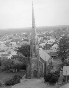
Photograph, St. Matthew’s Presbyterian Church from town hall clock tower c1959-1960
... the Stawell Town Hall. The photo shows an aerial view of the church... taken from the Stawell Town Hall. The photo shows an aerial view ...St. Matthew’s Church 1959-1960 taken from town hall clock tower. Photo taken around 1959 -1960. The Centenary book states brick fence and pillars were a gift from McCracken Family, but not in the year the church was built. This photo was used for the Centenary book cover and was taken from the Town Hall clock tower. The roof line in bottom right corner of photo is rear of town hall.Two photographs of St Matthew's Church taken from the Stawell Town Hall. The photo shows an aerial view of the church and houses behind the church. stawell religion -
 University of Melbourne, Burnley Campus Archives
Photograph - Black and white print, Aerial View of Burnley Campus c.1965, c. 1965
... Aerial View of Burnley Campus c.1965...aerial view...Black and white photograph. Enlarged photograph of aerial...aerial view burnley college yarra river Black and white ...Black and white photograph. Enlarged photograph of aerial view of Burnley College encompassed by the Yarra River and showing the surrounding suburban areas. Mounted on cardboard.aerial view, burnley college, yarra river -
 Lakes Entrance Regional Historical Society (operating as Lakes Entrance History Centre & Museum)
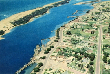
Photograph, 1960c
... Colour photograph aerial view of the township, shows also... Hotels Colour photograph aerial view of the township, shows also ...Copied from postcardColour photograph aerial view of the township, shows also Cunninghame Arm, the hummocks and distant view of Bullock Island and the entrance. Lakes Entrance Victoriaislands, jetties, memorials, hotels -
 City of Ballarat Libraries
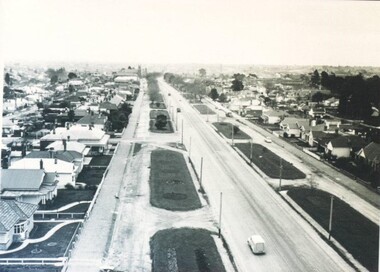
Photograph - Card Box Photographs, Victoria Street, Ballarat circa 1940
... aerial view...Aerial view looking west from Stawell Street.... Street, Ballarat circa 1940. Aerial view looking west from ...Aerial view looking west from Stawell Street.victoria street, ballarat, ballarat east, streetscape, bulding, garden, houses, private dwelling, vehicle, aerial view -
 Heidelberg Golf Club
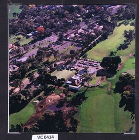
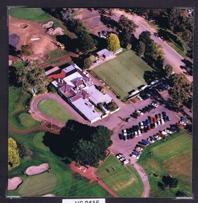
Photograph - Aerial Photograph, Heidelberg Golf Club 1998, 1998
... Aerial view of the Heidelberg Golf Club course... Colour photograph. Aerial view of the Heidelberg Golf Club course ...Aerial view of the Heidelberg Golf Club course and buildings.Colour photograph.hgc clubhouse 1998, aerial photographs -
 Stawell Historical Society Inc
Photograph, B P Petrol Depot on the Western Highway -- Aerial View -- Coloured
... B P Petrol Depot on the Western Highway -- Aerial View...Aerial View along Western Highway (BP Depot)... -- Aerial View -- Coloured Aerial View along Western Highway (BP ...Aerial View along Western Highway (BP Depot)stawell -
 Stawell Historical Society Inc
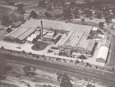
Photograph, North Western Woollen Mills -- Aerial View Showing Wood pile and train line at left
... North Western Woollen Mills -- Aerial View Showing Wood...North Western Woollen Mills -Framed - Aerial View...North Western Woollen Mills -Framed - Aerial View Stawell ...North Western Woollen Mills -Framed - Aerial ViewLarge Framed Photograph stawell industry -
 Stawell Historical Society Inc
Photograph, North Western Woollen Mills -- Aerial View
... North Western Woollen Mills -- Aerial View...North Western Woollen Mills - Framed - Aerial View...North Western Woollen Mills - Framed - Aerial View Stawell ...North Western Woollen Mills - Framed - Aerial Viewstawell industry -
Port Melbourne Historical & Preservation Society
Photograph - Aerial view of Port Melbourne, c. 1972
... Aerial view of Port Melbourne...Aerial photographic view of Port Melbourne c1972... Street) Port Melbourne melbourne Aerial view of Port Melbourne ...Aerial photographic view of Port Melbourne c1972local government - city of port melbourne -
 City of Ballarat Libraries
Photograph - Card Box Photographs, Ballarat Base & St John of God Hospitals, Ballarat circa 1960
... aerial view...Aerial views of the Ballarat Base and St John of God... street noth building aerial view ...Aerial views of the Ballarat Base and St John of God Hospitals.ballarat base hospital, st john of god hospital, ballarat, drummond street noth, building, aerial view -
 Stawell Historical Society Inc
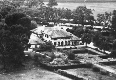
Photograph, “Warranooke” Homestead in Glenorchy 1867 -- aerial view
... “Warranooke” Homestead in Glenorchy 1867 -- aerial view...Aerial View of “Warranooke” Homestead built 1867 enlarged... -- aerial view Aerial View of “Warranooke” Homestead built 1867 ...Aerial View of “Warranooke” Homestead built 1867 enlarged 1926. glenorchy -
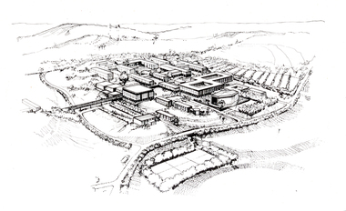 Federation University Historical Collection
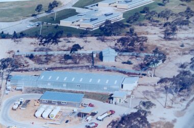
Photograph - Black and White, Aerial Depiction of a Plan for the Mount Helen Campus, c1969
... Artwork showing an aerial view of a planned academic campus... Helen Campus, c1969 Artwork showing an aerial view of a planned ...The new campus at Mount Helen was part of the Ballarat School of Mines, and was known as Ballarat Institute of Advanced Education. The drawing was prepared in the early stages of the Mount Helen campus development, while Stage I buildings ('E', 'F', 'G') were constructed. the Union Building (now Albert Coates Centre), Library, 'S' Building and student accommodation were in the design stage. The original drawing was photographed by using special equipment in the offices of Department of Crown Lands, treasury Place, Melbourne.Artwork showing an aerial view of a planned academic campus at Mount Helen. .1) Black and white print of a line drawing. 2) Transparency of above imagefederation university, federation university australia, feduni, university of ballarat, ballarat institute of advanced education, harrison, vernon, campus, mount helen -
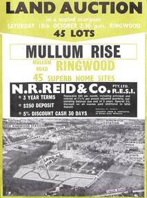 Ringwood and District Historical Society
Flyer, Land Auction Advertisement, Mullum Rise, Ringwood - 1970
... Double sided leaflet with aerial view of part of Ringwood..., Mullum Rise, Ringwood - 1970 Double sided leaflet with aerial ...Double sided leaflet with aerial view of part of Ringwood showing subdivision site, terms of sale, layout of streets and allotments, and summary of local features and services.Land auction, Saturday, 10th October (1970). 45 home sites. Subdivision includes Mullum Mullum Road, Hugh Street, Rollington Drive, Cassandra Court, and Jeffrey Drive. Surveyors - R.G. Lee Pty. Ltd., 6 Davis Street, Richmond. Agents - N.R. Reid & Co., 173 Coleman Parade, Glen Waverley, (Telephone) 560 0355 A.H. 560 0361 and Safeway Centre, Boronia Road, Boronia, (Telephone) 762 1022 A.G. 795 2887, also at East Malvern and Mount Waverley. -
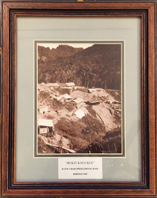 Tramways/East Melbourne RSL Sub Branch - RSL Victoria Listing id: 27511
Picture, Bukit Knuckle
... . Images shows an aerial view of the camp and surrounding landscape. .... Images shows an aerial view of the camp and surrounding landscape ...Framed print of a sepia photograph showing the camp at 'Bukit Knuckle', an operational base of the 3RAR in Borneo. Images shows an aerial view of the camp and surrounding landscape. Underneath the print is added 'BUKIT KNUCKLE' B COV 3RAR OPERATIONAL BASE, BORNEO 1965 On reverse is marked 'Donated by Keith Matthews 1995'bukit knuckle, sungei koemba, 3 rar, indonesia malaysia confrontation -
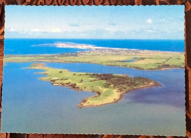 Phillip Island and District Historical Society Inc.
Photographs, Victoria Conservation Trust, Churchill Island, 1980s
... on Churchill Island including an aerial view, homestead, outbuildings... including an aerial view, homestead, outbuildings, vegetation, views ...3 coloured postcards and 8 coloured photographs of scenes on Churchill Island including an aerial view, homestead, outbuildings, vegetation, views, cairn and coastal scenes.Postcards say Churchill Island, Victoria. Victoria Conservation Trustchurchill island, churchill island heritage farm, churchill island - homestead, samuel amess -
Whitehorse Historical Society Inc.
Document, A Plan for Mitcham, 1960s
... Mitcham Shopping Centre to provide off-road parking. Aerial view... Centre to provide off-road parking. Aerial view illustration ...Mitcham chamber of Commerce pamphlet plans for developing Mitcham Shopping Centre to provide off-road parking. Aerial view illustration of shopping centre on cover.Mitcham chamber of Commerce pamphlet plans for developing Mitcham Shopping Centre to provide off-road parking. Aerial view illustration of shopping centre on cover.Mitcham chamber of Commerce pamphlet plans for developing Mitcham Shopping Centre to provide off-road parking. Aerial view illustration of shopping centre on cover.parking, mitcham shopping centre, armstrong, raleigh edward, colombo street, mitcham, elizabeth street, mitcham, mitcham road, mitcham, whitehorse road, mitcham, mitcham chamber of commerce -
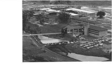 Federation University Historical Collection
Photograph - Photograph, Black and White, Ballarat Institute of Advanced Education Mount Helen Campus, 1974
... Aerial view of Ballarat Institute of Advanced Education... of Advanced Education Mount Helen Campus, 1974 Aerial view of Ballarat ...Aerial view of Ballarat Institute of Advanced Education Mount Helen Campus. It shows the oval and two dams in close proximity to the E.J. Barker Library. 1974ballarat institute of advanced education, library, mt helen, aerial, mount helen campus, e.j. barker library, mount helen library -
Glenelg Shire Council Cultural Collection
Photograph - Photograph - Aerial view from NE Portland Harbour, c. 1967
... Photograph - Aerial view from NE Portland Harbour...Black and white photograph unframed; aerial view from NE... Cliff Street Portland great-ocean-road Photograph - Aerial view ...Port of Portland Authority ArchivesFront: 19 JUN 1997 Back: 19 JUN 1997port of portland archives, ocean railway pier, portland harbour -
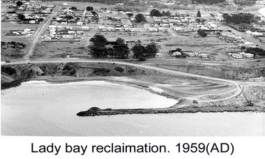 Glenelg Shire Council Cultural Collection
Photograph - Photograph - Lady Bay reclamation, c. 1960
... breakwater. Lady Bay Reclamation: Aerial view looking West showing... with man-made breakwater. Lady Bay Reclamation: Aerial view looking ...Port of Portland Authority archivesFront: (no inscriptions) Back: Lady Bay Reclamation 1959 (black pen, upper left)port of portland archives, lady bay, reclamation -
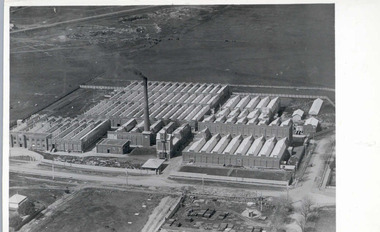 National Wool Museum
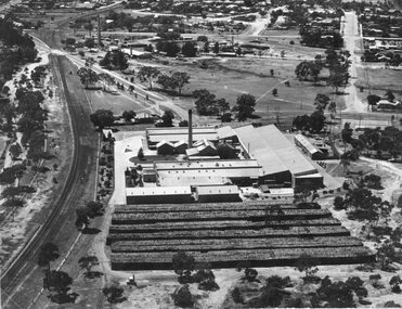
Photograph - Valley Worsted Mill, 1923
... Photographic postcard, black and white. Depicts an aerial... and white. Depicts an aerial view of the newly constructed textile ...Photographic postcard depicting the newly constructed Valley Worsted Mill, c.1923.Photographic postcard, black and white. Depicts an aerial view of the newly constructed textile mill. A chimney stack and many saw toothed roofs can be seen.POST CARD / CORRESPONDENCE ADDRESS ONLY / KODAK / AUSTRALtextile mills, valley worsted mill foster valley mill pty ltd, aerial photography, factory, wool, industrial building -
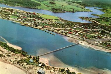 Lakes Entrance Regional Historical Society (operating as Lakes Entrance History Centre & Museum)
Photograph, 1975c
... Colour photograph aerial view of the township, also showing... Jetties Aerial Photograph Colour photograph aerial view ...Copied from postcardColour photograph aerial view of the township, also showing North Arm, Cunninghame Arm, footbridge, and kiosk and Lifesaving Club on hummocks. Lakes Entrance Victoriawaterways, township, islands, jetties, aerial photograph -
 Stawell Historical Society Inc
Photograph, North Western Woollen Mills with the Rail line in foreground -- Aerial View
... foreground -- Aerial View...North Western Woollen Mills Aerial View. Rail line... in foreground -- Aerial View North Western Woollen Mills Aerial View ...North Western Woollen Mills Aerial View. Rail line in foregroundstawell industry -
 Heidelberg Golf Club
Photograph - Aerial Photograph, Heidelberg Golf Club 1998, 1998
... Aerial view of the Heidelberg Golf Club, clubhouse, bowling... Colour photograph. Aerial view of the Heidelberg Golf Club ...Aerial view of the Heidelberg Golf Club, clubhouse, bowling green and carpark.Colour photograph.hgc clubhouse 1998, aerial photographs -
 Kiewa Valley Historical Society
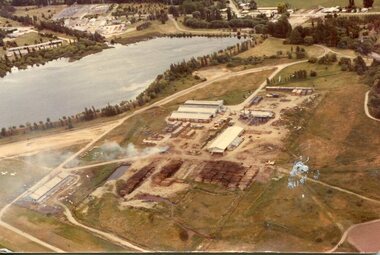
Photograph - Mt Beauty timber Industries, 1960's (estimate only)
... Colour photograph of aerial view of Mt Beauty Timber Mills... - Mt Beauty timber Industries Colour photograph of aerial view ...Hume and Hovell discovered the area in 1824 and by the end of the 19th century the valley was transformed by logging, dairy and beef cattle properties and tobacco farms. Timber was required for construction of McKay Creek Power Station which began construction in 1951 and also the camps and houses for the workers and their families. There was a need for housing and infrastructure for an increasing population of workers for the hydro-electric scheme as there was a general shortage of this commodity. A timber mill was started in Tawonga by Mates, of Albury, in 1945, and electricity became available in 1946 the S.E.C. bought the mill, and enlarged it. In 1960 it was purchase by a local family. They also started a timber mill in Mt Beauty and worked both until 1980 when they closed the Tawonga mill and enlarged the mill called Mt. Beauty Timbers Pty Ltd which employed approximately 50 people. A pictorial record of the development of the Mt Beauty community and the local timber industry.Colour photograph of aerial view of Mt Beauty Timber Mills and surrounding area including pondage and part of airfield. Photo taken in 1960’s (estimate only)Handwritten in ink on back of photograph in very faint writing – Recent photo of Mt Beauty Timber Industries Mt Beauty Operationsmt beauty timber industry, timber industry, timber mill, secv -
 Rutherglen Historical Society
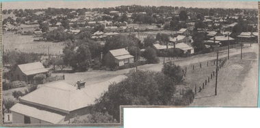
Newspaper - Image
... , date unknown. This one is an aerial view of Rutherglen...), then pasted onto orange paper, date unknown. This one is an aerial ...One of a group of photographs of Rutherglen collected from magazines (Pix or People or Post), then pasted onto orange paper, date unknown. This one is an aerial view of Rutherglenrutherglen -
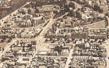 St Patrick's Old Collegians Association (SPOCA)
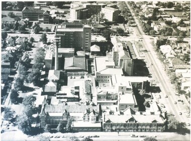
Photograph - Buildings, Aerial, c.1930
... Aerial View of East Melbourne & Fitzroy from North, showing... melbourne Buildings, Aerial, c.1930 Photograph Aerial View of East ... -
Glenelg Shire Council Cultural Collection
Photograph, View of Portland Harbour, c. 1974
... Black and white photograph. Aerial view taken from the west... View of Portland Harbour Black and white photograph. Aerial ...Port of Portland Authority archives.Front: (no inscriptions) Back: (no inscriptions) -
Glenelg Shire Council Cultural Collection
Photograph, View of Portland Harbour, c. 1974
... Black and white photograph. Aerial view taken from the west... View of Portland Harbour Black and white photograph. Aerial ...Port of Portland Authority archives.Front: (no inscriptions) Back: (no inscriptions)port of portland, henty park, fishing fleet -
Glenelg Shire Council Cultural Collection
Photograph - Photograph - aerial view of Portland, c. 1974
... Photograph - aerial view of Portland...Black and white photograph. Aerial view taken from the west... Cliff Street Portland great-ocean-road Photograph - aerial view ...Port of Portland Authority archives.Front: (no inscriptions) Back: (no inscriptions)port of portland archives, aerial photography, portland harbour