Showing 622 items
matching black mountain
-
 Montmorency/Eltham RSL Sub Branch
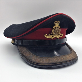
Cap, Peaked, Dress, Royal Australian Artillery, 1952, 1952
Typical British and Commonwealth full dress cap for 1950sBlack peaked cap with black wool crown and red piping and hat band. Royal Australian Artillery gilt cap badge. Black patent leather chin strap with 13mm dia. brass AMF buttons. Black patent letter peak with 20mm gold wire edging and green undersides. Tan leather sweat band. Tan cloth lining with green printed manufacturer's name and purple stamped details Green printed. "Hobson & Sons (London) Ltd. Purple stamp. "1952 6 7/8 Made in England" Note - no personal markingsheadgear, cap -
 Montmorency/Eltham RSL Sub Branch
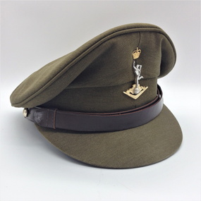
Cap, Peaked, Royal Australian Signals, 1988, 1988
Standard issue peaked cap for 1988.Peaked khaki cloth cap with brown 18mm leather chin strap with two 13mm AMF gilt buttons (crown and map only). Khaki cloth covered peak. Royal Aust. Signals cap badge. Brown leather sweat band. Plastic covered, grey cloth liner with black stamped manufacturer's, etc. details. Australian Government Clothing Factory and logo Size /|\ 56 VIC 1988 (Note - no personal markings) headgear, cap -
 Lorne Historical Society
Map, F W Niven Lithos, The Mountjoy Lorne Estate, 1889
In 1888 a company was formed to acquire and subdivide the land of the Mountjoy Brothers. The land totaled 197 acres and included Erskine House. The land colored red was that of the Mountjoys. The subdivision map was printed in 1889A paper map of the Mountjoy Estate Lorne , showing allotments, with their owners, and naming land use. It has four black and white line drawings , Erskine House, Mountain View’s, the Rapids, Erskine House sea view and Erskine Falls. The map is largely black and white with red and blue colouring. The map is mstuck to brown paper. lorne, subdivision map, erskine house, mountjoy brothers, -
 Mission to Seafarers Victoria
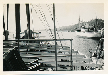
Photograph - Photograph, Black and white, Allan Charles Quinn, Passing ship on Elbe River, 4 June 1950
This series of photographs captures life at sea and the conditions on the ship M/S "Mongabarra" Goteborg in 1950.This photograph is part of the Allan Quinn collection, which is a pictorial autobiography, and it represents one of many moments of his time abroad as a seafarer.Black and white photograph of the Elbe River in Germany. In the foreground is a lounge area with chairs and railing. Behind this are masts, rigging and rope near what appears to be a jetty with partial roofing. In the middle ground is the Elbe River running from the bottom right to middle left of the photograph. In the background is a passing ship and a mountain.germany, 1950, ship, deck, mast, chairs, mongabarra, allan quinn collection, allan quinn, tailing, elbe river, mointain -
 Greensborough Historical Society
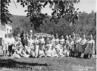
Photograph - Digital image, Nance Reardon, Briar Hill Elderly Citizens 1969, 25/11/1969
Group photograph of Briar Hill Senior Citizens club at Mountain Grand Warburton in 1969.Digital copy of black and white photograph.briar hill senior citizens club -
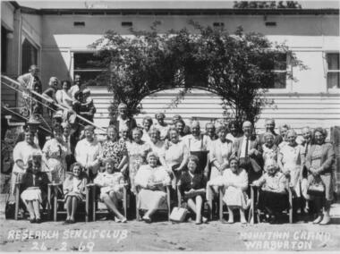 Greensborough Historical Society
Photograph - Digital image, Nance Reardon, Research Senior Citizens 1969, 24/02/1969
Group photograph of Research Senior Citizens Club at Mountain Grand Warburton 24/02/1969.Digital copy of black and white photograph.simons family, grimshaw street greensborough -
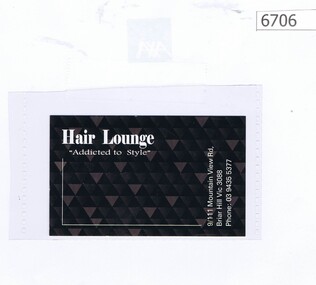 Greensborough Historical Society
Business card, Hair Lounge "Addicted to Style", 2019_
Hair Lounge is a hairdresser Shop 9 111 Mountain View Road Briar HillPart of a collection relating to local businesses.Printed both sides in black on white cardboardAddress, telephone no. and space for appointmentshairdressers -
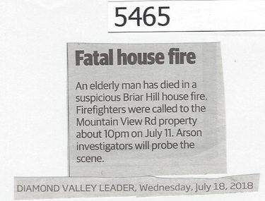 Greensborough Historical Society
Newspaper Clipping, Diamond Valley Leader, Fatal house fire, 18/07/2018
An elderly man has died in a suspicious house fire at Mountain View Road, Briar Hill.News article 1 page, black text.briar hill fire, mountainview road briar hill -
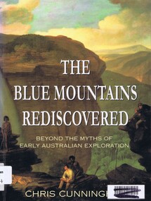 Greensborough Historical Society
Book, Chris Cunningham, The Blue Mountains rediscovered: beyond the myths of early Australian exploration, by Chris Cunningham, 1996_
Written from both an historical and geographical view, this book tells the story of early inland exploration across the Blue Mountains.Paperback, 192 p., col. photographs, black and white maps.blue mountains nsw -
 Glenelg Shire Council Cultural Collection
Souvenir - Tea Towel - Casterton, Victoria, c. 2011
... and mountains in background. Black print: 'MUSTER TIME AUSTRALIA..., trees and mountains in background. Black print: 'MUSTER TIME ...Cotton souvenir tea towel. Back white, front yellow, green border, images of kelpies and sheep and a man on horseback rounding up sheep with a dog. Windmill and tanks, shed, trees and mountains in background. Black print: 'MUSTER TIME AUSTRALIA'; 'CASTERTON Birthplace of the kelpie'. 'Designed in Australia ©' in bottom bordersouvenir of casterton, kelpie, kelpie muster -
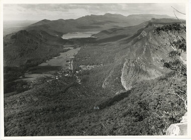 Halls Gap & Grampians Historical Society
Photograph - B/W
The photo is of the Fyans Valley, taken from Chatauqua Peak. Lake Bellfield and Mount William can be seen in the background. The photo belonged to the Forestry Commission Victoria.A photo of a valley between mountain ranges. A lake can be seen in the background. A road runs through the middle of the valley with houses on both sides."Fyans Vaslley from Chataqua Peak. Incl L. Bellfield & Halls Gap. photo belongs to F.C.V. Stawell. Return to V. Young, Horsham" written on back in green pencil. The "Chatauqua Peak" has been overwritten in black-lead pencil. "LC.71" is also written on the back in black-lead pencil.scenery, grampians ranges -
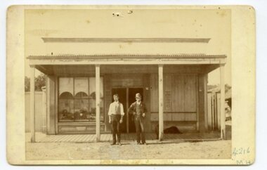 Ararat & District Historical Society (operating the Langi Morgala Museum)
Photograph, c. late19thC
This was the first police station built in Watgania, and it was probably built during the goldrush era of late19C to early 20C.The photo is of local significance to Watgania and the Ararat district because of its rarity and because of its subject. There is now (in the year 2023) little or nothing left of the township of Watgania, north of Willaura, though there are still several inhabited properties in this area, which shelters close under the eastern face of the Grampians mountains. The figures in the photo add to its significance, since a good deal of information about the goldfields can be gleaned from their manner and their dress.Black and white photograph mounted on cardboard. Photo shows two men standing outside a building. The man on the right is dressed in a suit and is wearing a hat. The other man is dressed in suits pants and a vest. The window to the right of the front door of the building is boarded up.Inscription: on front: "4216 / MH". Stamped on back: "F.W HARGREAVES". Inscription: on back: 592P (this is its Osborne nbr, and corresponds to a photo-negative taken of the original photo).goldfields, police, watgania, ararat, gold rush, mount william, grampians, police station -
 Kiewa Valley Historical Society
Photograph from Lake Guy, Bogong Village, Scene from shores of Lake Guy to Mountain range, 1930s to 1950s
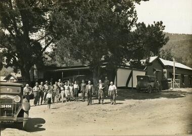
In 1940 Field Headquarters for the Kiewa Scheme were established at Bogong with office, workshop facilities and accommodation for workmen, staff and some families constructed. (There had been a 'tent camp' on this site in 1939 but was destroyed by bushfires) Construction of accommodation continued until 1947. A total of 40 houses plus a hostel for single staff, post office, police station, medical centre and primary school all with water and sewerage and electricity supply. The staff hostel was known as Kiewa House and is now occupied by the Education Department. Lake Guy was named after Mr. L.T. Guy who was the Resident Engineer in charge of construction work and associated activities on the Kiewa area. He held this position from 1939 to November 1946 when he was transferred to Head Office.The Bogong Township was developed firstly as an accommodation centre (base camp) for construction workers employed under the Kiewa Hydroelectric Scheme. Due to the influx of European workers into the Township the beautification of the immediate surrounds(gardens etc.) had a distinct European flavour. This environment has been very beneficial for tourism in later years. Strict environmental control has not allowed for any extensive redevelopment in tourist accommodation and basically restricted it to the accommodation initially built for the construction workers. Activities such a bike riding, snow skiing, restricted horse riding and bush walking on the Alpine plains and mountains are now a viable part of the Kiewa Valley Tourist Industry. The lake is one of the many water storage storage reservoirs used to supply the power stations their main power to run the huge turbines generating the final product, electricityThis black and white photograph shot from the shores of Lake Guy toward the mountain range of the Victorian Alps details the early construction of the construction worker's accommodation of the Bogong Village. The paper is of 200gms and is not photographic paper and can be assumed to be a reproduction of an original photobogong village circa 1930 to 1950, kiewa hydro-electricity scheme, victorian alpine region mid 1900s -
 Kiewa Valley Historical Society
Photograph of Snow Covered Catchment Area Vic, Snow Covered Catchment Area Victorian Alps - 1950s, Circa 1950
This photograph details (early to mid1950s), the Victorian Alpine region when this remote area was part of a "lay back" rural landscape,occasionally visited by recreational adventurers and some wayward tourists. The mountain ranges had provided an adequate barrier against the way-would traveller, but with the opening up of this region by the provision of improved roadways and accommodation facilities, courtesy of the Kiewa Valley Hydro Electricity Scheme, changes such as tourism and its impact upon the "natural" state started to show its side effects (clearing of the land). The expansion of the European immigration numbers (1950s) coming into Australia was increasing after World War II which not only provided increased construction workers to the region but also immigrants who appreciated alpine regions. Some of these immigrants contributed to the expansion of the region and provided for a greater degree of diverse professions and rural related work force.This photograph depicts the borderline in time between an exclusively rural based population and respective activities(early 1900s)to the present (2000 on wards) integrated village, tourist and retiree/holiday area. The time when land was exclusively used in agriculture and Alpine grazing lands is over. The Kiewa Valley is loosing its hiding place and is becoming more and more a source of untapped residential land and winter time recreational adventure lands. The changes brought about by modern technologies involving recreational activities such as hang gliding, gliding (local airstrip), mountain bikes, car rallies and their associated clubs is providing for an increased short term population boost. These together with the attractions for retirees is changing not only the physical nature of the Kiewa valley but also its "soul".This item is a black and white photograph of a section of snow covered catchment area in the Victorian Alps in the mid 1900. It is on 200 gms paper but not on photographic paper and has a white boarder (3 mm).kiewa valley tourism, victorian alps, alternate energy supplies, alpine population growth -
 Kiewa Valley Historical Society
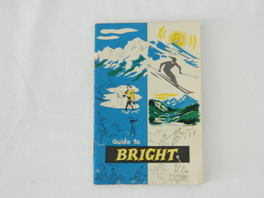
Pamphlet - Bright Tourism, Guide to Bright and District, late 1900s
This publication was produced in the early 1950s to provide the growing tourism trade (at this time), to the region with a more detailed overview of the facilities available to tourists of the region's attractions. This brochure is a very efficient and effective promotional publication. The increasing level of self promotion by local business and commerce sectors of the region the more sought after the region became and the greater the ability of the region to grow (non rural based economy). Some of the regions unique facilities and geological structures are well suited to those tourists who live in cities and "flat land" regional bush areas within Australia. This was a period when the average Australian domestic tourist was more able (finance and transport wise) to see more of their country within the short time they had for "holidays". In the late 1900s, however, with the increase to workers' recreational leave and better transportation (fares, ease of travel to overseas destinations) the local tourism numbers from other domestic locations have been steadily declining. From the 1970s onwards, the increased tourism demand from overseas tourists, for better facilities and easier access to these regional facilities, resulted in better transport, accommodation and communication, which has been a boon for all tourism within Australia. In the 21st century the world is becoming smaller and smaller for the international tourist, especially for those from crowded Asian cities. The greater attraction for "open" spaced locations such as this region are becoming a much sought after change of scenery. This pamphlet which targets the tourist, whether either from other Australian regions or the global tourist, is a good example of self promotion by a relatively small local population. This is especially significant because before the "tourist explosion" in the 1950s onward, these regional areas had a more introspective society with greater emphasis to locally established mores and values. The increased interactions with people from other areas and nations, combined with a greater global communication network is affecting those traditionally established mores to produce a some what unique social transformation which is constantly changing from one generation to the next. One important factor which tourism does bring is that it opens up the region to a wider range of people who look to the region for their own lifestyle changes.This pamphlet has a front cover in colour with the major activities in the region sketched depicting : sunshine, snow skiing, trout fishing, mountain climbing, golfing, swimming, alpine views, tennis, lawn bowls and picnics. The back cover is blank. The pamphlet is fastened together by two staples 30mm from top and bottom, and is folded with the cover slightly thicker than the fifteen pages. Thirteen pages have been printed on both sides. The first page has a black and white photograph of the hotel Alpine and the tall brick constructed Clock Tower. There are another five black and white photographs in the pamphlet.on front cover "Guide to BRIGHT"local tourism, regional information booklet, "time" related brochures, alpine local history -
 Kiewa Valley Historical Society
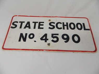
Sign - Bogong State School
Bogong State School opened in 1941 to provide an education for the employees of the State Electricity Commission of Victoria. The school had up to date equipment and received glowing reports from School inspectors. It closed c1986.Historical: The Bogong State School was opened for the children of S.E.C.V. workers who lived at Bogong in a remote part of north east Victoria. The nearest school would have been 14 miles away and over mountain roads subject to heavy construction traffic and extremes of climatic conditions. Metal sign painted white with thin red border and black block capital letters and numbers. There is a hole in the middle top and middle bottom of the sign."State School / No. 4590"state school. bogong. education. state electricity of victoria. kiewa hydro electric scheme. -
Kiewa Valley Historical Society
Papers - Mount Beauty Clubs, 1. Mount Beauty Schools' Band; 2) Souvenir of Mt Beauty Senior Citizens Club; 3) Gra-Y and Hi-Y Induction Ceremony
Community clubs in Mt Beauty have always been important due to the remoteness of Mt Beauty situated at the end of the Kiewa Valley and at the bottom of the surrounding mountains.Community clubs in Mt Beauty were and still are important for the well being of members of the community of all ages. Mt Beauty began as a construction town, built by the SECV for their workers on the Kiewa Hydro Electric Scheme. Situated at the end of the Kiewa Valley and at the bottom of the surrounding mountains it has become a tourist town with a strong community spirit and many clubs.1. Mount Beauty Schools' Band End of Year Concert 2002 - 2 A4 pages folded in half with black & white photos on outside cover 2.Souvenir of Mt Beauty Senior Citizens Club - 6 pages printed on 1 side only. Enclosed: Agenda for the official opening - Dec. 1972 3. Procedure for the 'Hi-Y' Induction Ceremony (no date) - 3 foolscap pages printed in blue ink on 1 side only.mt beauty school band, mt beauty senior citizens club, mt beauty gra-y and hi-y clubs, music, athletics -
 Kiewa Valley Historical Society
Photos: Bogong Hotel and Kiewa Valley
The Bogong Pub was a central point for social gatherings in the Kiewa Valley.Black and white photos framed with thick brown cardboard that is framed by two rows of lines around the photo thus forming a frame. The cardboard is folded in half to form a 'card' enabling the photo to stand. 1. People standing outside the Bogong Pub. The pub is behind trees. Two old/vintage cars are partially in the photo. 2.The Kiewa Valley showing paddocks, trees lining the Kiewa River and mountains in the background.bogong pub, kiewa valley -
 Kiewa Valley Historical Society
Photos - King Family Collection
The King family lived in Tawonga South where my older brother and sister went to school. We lived over the road from Wally Madison's farm. Later when a house became available, we moved into Valley Avenue, Mt Beauty. This is when I turned 5 and started my schooling. It was a long walk for a 5 year old as I remember. Then later we moved to 50 Lakeside Ave. I remember we loved living there as it was close to the school, footy ground and kindergarten. My father, Ted King, wad a carpenter and was involved in the building of many houses in Mt Beauty which was the home for the workers on the Kiewa Electric Scheme. So as they are part of the history of Mt Beauty I thought they may be useful to you as part of the history. The tennis photos, I vaguely remember Lou Hoad and Ken Rosewell giving exhibition matches in Mt Beauty. I may stand corrected on this, but I do remember my parents who were keen tennis players themselves were most excited at seeing these famous tennis players. As I was only 9 when we left Mt Beauty to live in Dimboola I still remember the shock of leaving a beautiful mountainous county side and arriving in a flat farming land next to a desert and seeing windmills One thing I do remember from school is, once a week (or fortnight) the teacher used to come around with a jar of little white pills, of which we were all to take. I really don't know what they were?? or for?? I also remember being taught to swim in the freezing cold river by a Mrs Smith who wore black bathers and wore her hair in a bun...... ...I am now in my 70s My father used to also carve intricate trays and jewellery boxes in his spare time. I think they were used for tennis trophies. by Diane Werner.x33 photos of small black and white photos of the Tawonga, Tawonga South and Mt Beauty - Photos not labelled but described as follows. See each photo for a possible label. A. Tawonga? B. Mt Beauty taken on the road to Bogong ? C. SEC Works D. Industrial buildings with mountains in the background E. Building site with wooden frame and 3 men F. Buildings with power poles G. Building site with lots of huts H. Buildings under construction I. Group of houses in the distance J. Group of houses in the distance K. Group of people in front of a building L. Group of 8 men sitting on timber planks, corrugated iron at back. M.& N. Building site with floor and upright timbers O. Mountain view with camp site in foreground P.& Q. Buiding site, several houses R.5 men at a building site S. portable building on trailer T & U. Mountain view V. Building site W. Group of men, car and mountains in background X. Cows Y. Pigs Z. 2 men standing next to cars. AA. Football players BB. Man painting a corrugated iron building CC. Football DD. Men in front of a building EE Buildings with mountains in background FF & GG Tennis payersHH & II. Electricity infrastructure -
 Kiewa Valley Historical Society
Photo - Mt Beauty c1948, Early photo of Mt Beauty Townhip c1948
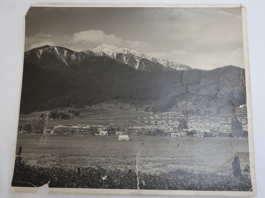
Mt Beauty was constructed by the State Electricity Commission of Victoria to house employees of the Kiewa Hydro Electric Scheme. Mt Beauty township looking south east from Hollond's property c1948. Only one transmission line has been built.In the foreground are houses in Simmond's Creek Road. Some houses in North Beauty. The town is still under construction - not all roads have been made and houses haven't any garden around them.This is an early photo of Mt Beauty during construction of the town.d It shows a few houses in Simmonds Creek Road. Large black and white photo of Mt Beauty township with snow on the mountains in the background.mt beauty township 1948, mt beauty construction, simmonds creek road -
 Kiewa Valley Historical Society
Map - Kiewa Hydro Electric Works Area
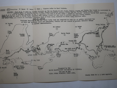
An early map of the Kiewa Hydro Electric Scheme Works Area prepared by the SECV for use when requesting access to the area. The regulations are printed regarding permits.During construction of the KHES there were restrictions on access to the area. This map identifies the land marks and states the regulations for entry to the area.Black and white map folded into three showing a legend with the townships, camps, gates and dams marked.Also indicating the roads, rivers, mountains and infrastructure of the KHES. khes works area, map of khes -
 Kiewa Valley Historical Society
Apple Peeler and Corer
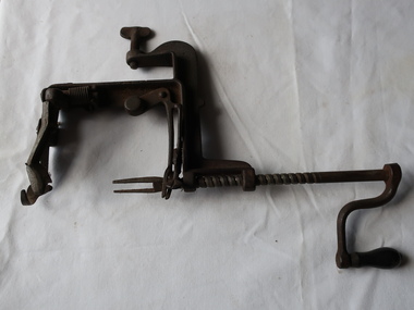
Hand operated . Made in 1880. A novel way of presenting an apple to eat with or without the skin. Used by a resident in the Kiewa Valley.Black metal apple peeler with clamp, winder, fork grip and peeler blade'Made by Goodfell Co./Antrim N. H. / USA' and 'White Mountain Apple' embossed along spine N = New H = Hampshireapple corer, apple peeler, kitchen utensil -
 Kiewa Valley Historical Society
Photo - McKay Pipeline
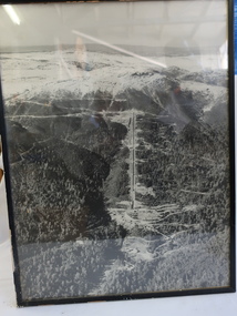
... down the mountain. It has a black plastic frame...., is above the ground going down the mountain. The McKay pipeline ...The McKay pipeline was built by the SECV during the construction of the Kiewa Hydro Electric Scheme. It begins at the McKay Power Station, is above the ground going down the mountain.The McKay pipeline was built by the SECV during the construction of the Kiewa Hydro Electric SchemeBlack and white large photo of Mt McKay's pipeline going down the mountain. It has a black plastic frame.no 1 pipeline mckay power station -
 Kiewa Valley Historical Society
Video Cassette - High Mountain Country, Shire of Bright
The Upper Kiewa Valley is part of the Shire of Bright, now known as Alpine Shire. Information presented for 15 minutes on a screen using a video cassette enabling multiple people to view it. Information presented digitally on video by the Shire of Bright.Black plastic cover with label on the spine - typed and faded: Typed on spine: 'High Country / Duration: 15 minutes'high mountain country, shire of bright, video cassette -
 Kiewa Valley Historical Society
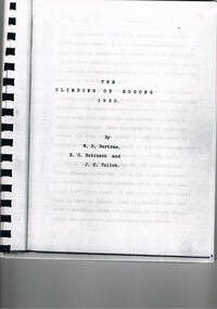
Book - Non Fiction History, The Climbing Of Bogong 1932, 1933
The historical documented account of the first winter traverse from Mt Hotham across Mt Bogong. The extreme winter conditions of the region was a barrier for all except the three pioneers of this expedition.This book details the the determination and true spirit of the Australian psyche to overcome extreme hardships and have the endurance to fulfill an adventure in the early 1900's.A photo copy of a black spiral bound book written in 1933 covering the memoirs and photos of only the first (at the time of writing) winter climbing of Mount Bogong in1932. It was written by Jack K.Tulloh (a journalist), E.C. Robinson and W.D. Bertram. This book was photocopied and rebound for the 60th anniversary of the climb.The Climbing Of Bogong Mountain 1932. First page author's dedication: To Bill from Jack 17/2/1933. Second page address: To jack Eddie & Bill " In recognition of your epic journey 50 years ago" John, Helen, David, Iain, Andrew & Hamish, also written in freestyle underneath and in brackets "Bertrams all" underneath signed by Gwen Tulloh, Barbara Betram and Ann Robinson The third page written in free hand " Inscribed by those who lunched9WELL0 on the golden anniversary of the trip 17/8/82. Next to a photo of the three climbers their signatures.climbing mount bogong, victorian alps in winter, snow at mt bogong 1920's winter sports, skiing, mt bogong, book, snow, cross country skiing -
 Kiewa Valley Historical Society
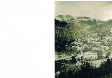
Photograph Bogong Township, Bogong Township Circa 1940s right side view, circa 1950
The Bogong Township (circa 1930s) was constructed by The State Electricity Commission of Victoria as a base camp for construction workers under the Kiewa Hydroelectric Scheme starting in 1938. The Scheme employed 4000 men during its construction phase. A small number were first housed at Bogong Village and when required the Mount Beauty Township was established(1949). Construction at the dams and Power Stations was interrupted during World War II. June 1951 started construction at full pace. The Bogong Township was developed firstly as an accommodation centre (base camp) for construction workers employed under the Kiewa Hydroelectric Scheme. Due to the influx of European workers into the Township the beautification of the immediate surrounds(gardens etc.) had a distinct European flavour. This environment has been very beneficial for tourism in later years. Strict environmental control has not allowed for any extensive redevelopment in tourist accommodation and basically restricted it to the accommodation initially built for the construction workers. Activities such a bike riding, snow skiing, restricted horse riding and bush walking on the Alpine plains and mountains are now a viable part of the Kiewa Valley Tourist Industry.Scanned copy of original black and white photo. Paper manufacturer is Kodak. Paper is Kodak XtraLife II.On reverse side "Kodak ExtaLife II paper"bogong village, bogong township, sec alpine constructions, victorian alpine tourism, winter sports. -
 Kiewa Valley Historical Society
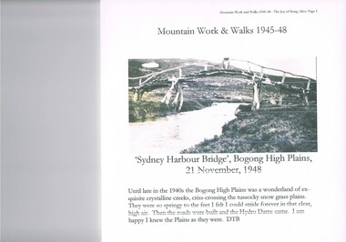
Journal - Reference, Mountain Work and Walks 1945-48,The Joy of Being Alive, circa 1950s
This journal detailing the author and friends walks and observations together with black and white photographs of the Kiewa Valley and the Bogong high plains regions during various "walks during the years 1945 to 1948. These walks were undertaken during the various Hydro - electricity generating plants and infra structures were being installed. It relays how the walker and adventurer enjoyed the pristine Alpine regions of Victoria. The wilderness and higher sense of adventure encountered by the author and his "walking party" is now no longer that intense. The isolation of the region was, at that time, still a barrier for the casual adventurer and required a dedication of the "pioneer" mountain walker.The significance of this journal is that both the photographs and accounts of those intrepid adventurers walking throughout the Victorian Alps and the Bogong High Plains details the countryside in one of the remaining years of relative pristine and minimal "tourist" developed regions of rural Victorian. The necessity of greater electrical power supply to the rapidly growing demand from cities and larger towns, post World War II immigration, had resulted in drastic changes to the infrastructure of the Victorian Alpine regions and particularly the Kiewa Valley. The photographs and the written accounts of the "adventurers" in this journal presents the last phases of the " Australian rough outback environment" and also the typical "bush wise" city/town dweller that although lived in towns and cities still had the adventurers heart of their fore fathers.This item has been photocopied by the author of his journal, consisting 27 pages of A4 size paper. A covering letter by the author is at the front of this loose leafed journal. The journal is bound in a yellow plastic cover with spirals. At the back is a 2 page biography of Myrtle Emily (Grigg) Deamer 1922-2006, then a photo of Meg with baby Bryn and son Tony followed by a letter from David BottomleyThe author's correspondence and covering letter has his signature "D Bottomley"alpine country, bush walking, bogong mountain, alpine adventures -
 Kiewa Valley Historical Society
Book - Non Fiction History, The Kiewa Story, circa 1993
This book provides in chronological order the development of the Kiewa Hydro-electricity scheme from the first concept (1911) to final construction work (1961). It covers the first attempt to utilise the power of the Victorian Alps water system. It started from a private syndicate and developed to the current State Electricity Commission of Victoria. The incentive for the Hydro scheme was to make money and not as an alternative to the carbon producing coal fired power plants. These coal fired power plants were increasing in numbers to service an ever increasing demand made by population expansion, especially in cities and large rural settlements. This demand spiraled up after World War II when there was a tremendous spike in immigration numbers due to refugees and displaced persons in Europe. The ability to utilise the untapped water provided by the winter snow fields, for a higher yield in electricity, was a powerful incentive to overcome the physical hardships in this remote Alpine region. Future power requirements may initiate the re-installation of the other two power stations(Pretty Valley and Big Hill) covered in original Scheme. This publication not only covers the development of the Kiewa Valley region with respect to population (within a socio-economical framework) but also the subtle but yet strong physical changes of a relatively pristine alpine region. The demands that an ever growing regional population places on the environment is clearly documented in print and black and white photographs. The working and living conditions of those who constructed and gave life to this hydro scheme is well documented in this book. It may be viewed as spartan now but was relevantly good at that moment in time, especially for those workers fleeing a devastated European environment. The successful planning and consideration to minimising any intrusion upon the natural alpine forests and high plains can viewed as an example (compared to the Tasmanian Hydro schemes) of how future hydro schemes (an inevitable requirement) will proceed. Most rural towns (in the early 1900s) were built by unencumbered rural based citizens, with the exception of Mount Beauty and Falls Creek. These two settlements were brought into life by a State (Victorian) Authority for a specific function and program. They were a gated community, that is, only open to construction workers involved with the hydro scheme. All facilities within these communities were provided by the State Electricity Commission of Victoria. The impact on the social, financial and individual independency of the community, by the transition from the S.E.C .environment to one of local government (Shire of Bright), had in some cases a severe impact.This hard covered book has a green cover with pictures on the front and back covers. The front cover has a coloured picture of a snow covered Mount Bogong taken from the opposite mountain range. The valley between both ranges has a whisk of mist over it. At the bottom of this picture are three black and white photographs covering the construction of the Kiewa Hydro - Electricity Scheme. On the back cover is a photograph, (black and white) detailing the Bogong village and Junction dam containing lake Guy. The inside front cover is a black and white photograph which details the construction of the West Kiewa tailrace tunnel during April 1951. The inside back cover is a black and white photograph of the concrete pour at the Clover Dam circa 1952. All photographs and sketches are in black and white. The pages are approximately 160 g/m2 and those which have photographs are on gloss paper.Book spine: "The Kiewa Story Graham Napier Geoff Easdown" alongside this is a white framed circle with white spokes radiating out and underneath in white lettering SECkiewa valley, hydro scheme, victorian alpine region, electricity generators, graham napier, geoff easdown -
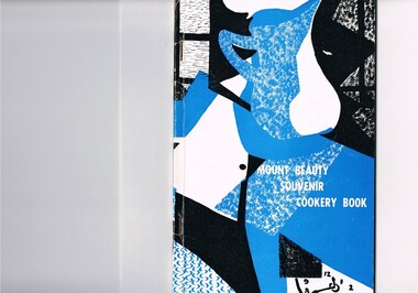 Kiewa Valley Historical Society
Book - Reference Cooking, Mount Beauty Souvenir Cookery Book x2, Circa 1962
This cookery book was printed in the early 1960s for the purpose of obtaining the necessary funds for the construction of the Mount Beauty swimming pool. The advertisements within this book covers local traders of this time frame, for example, the Bogong Hotel which is no longer operational. the culinary measurements are in Imperial measures(pounds and ounces). The book has sections for continental dishes and sweets (Australian flavour), special dishes for Lent, cakes (farmhouse fruit cake), jams, marmalades (home made), marrow and apple chutney. Some of these recipes are early 20th Century related and in the 2000s are not sought after. The food "take away" lifestyle has been responsible for the demise of a lot of the recipes in this book. The swing away from home grown produce has been not only a lifestyle change but also the faster pace of living in rural areas. The specialisation and redefined development of the local produce store (previously provided everything the rural shopper needed) was a forced move due to larger and cheaper city born fresh food supermarkets. Although there are still some local produce store within the region these will in time vanish. This cookery book was produced just after Mount Beauty was released from an SEC "closed" community in 1961(see KVHS 0134) and the town then had to fend for itself. This book was compiled and produced because the town needed a swimming pool (which possible would have been provided had the SEC still been responsible). The book demonstrates the strong rural psyche of rallying together for the good of all and united for something which would be of benefit to all. The period 1961 to the 1970s was one of great change for Mount Beauty. The SEC protective cage was a blessing for some but a goal for others. The independence that was gained after the SEC left provided for a drastic "make over" in regards to the facilities provided for the "locals" and that for the tourists. An increase in tourist related industries such as snow skiing in winter, hang gliding and gliding, mountain bike rallies, bush walking and horse riding, all of which have supply outlets in the town, has provided a more cosmopolitan atmosphere. These activities and the greater interaction with populations outside of the region has reduced the "hermit" type feel of the town psyche.This recipe book consists of eighty nine pages in black and white print. It contains black and white sketches, recipes of local domestic cooks and advertisements covering local traders. The cover is approximately 280 g/m2 in weight and the pages are at 90 g/m2 in weight. The cover has a design in the style of Abstract Expressionism (period 1950-1960s) of identifiable (clock,jug,fruit,window) and abstract objects in tints of blue and shades of black. This was designed by Cheryl Ryder of the Mount Beauty High School, under supervision of Mr I Baker (Art Teacher)On the foreword(page two and page three) "Mt. Beauty Souvenir Cookery Book First Edition" . This foreword was presented by Rosa Kinnear, President, Ladies' Auxiliary 2nd copy - no inscriptionrecipe, cooking, food, domestic, kitchen, local history, comfort food, pioneer cleaning methods -
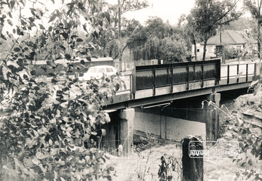 Eltham District Historical Society Inc
Photograph, Mountain View Road railway bridge, Montmorency
... melbourne bridges railways mountain view road montmorency Black ...Black and white photograph of railway bridge, Mountain View Road, Montmorencybridges, railways, mountain view road, montmorency