Showing 1059 items matching "boundaries"
-
 Eltham District Historical Society Inc
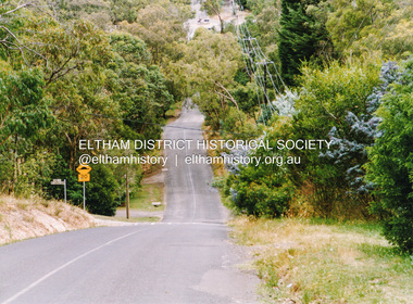
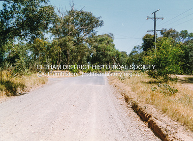
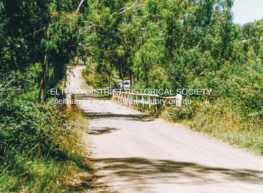
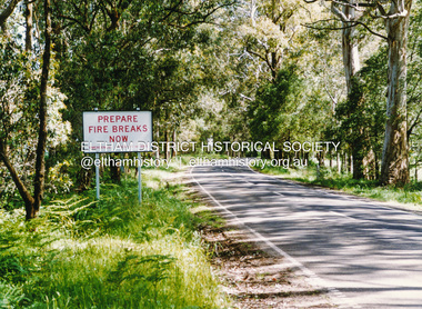
Photograph, Doug Orford, Silver Street, Eltham, near Vine Street, 1991, 1991
From a collection of 35 photos taken by Doug Orford at 35 specific locations along the exact boundary of the then Shire of Eltham.Colour photographeltham, silver street -
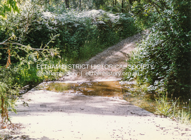
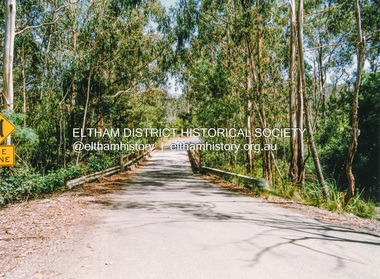
 Eltham District Historical Society Inc
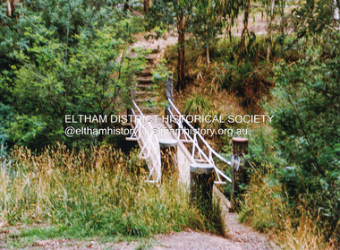
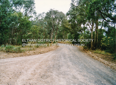
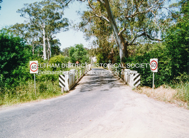
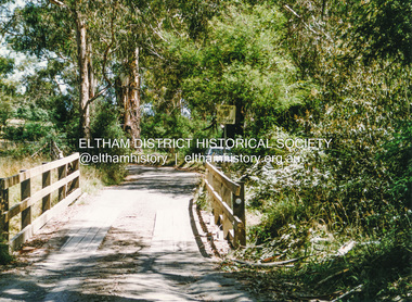
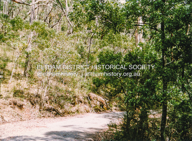
Photograph, Doug Orford, Footbridge across Diamond Creek near Gum Glade, Eltham, 1991, 1991
From a collection of 35 photos taken by Doug Orford at 35 specific locations along the exact boundary of the then Shire of Eltham.Colour photographeltham, bridges, gum glade -
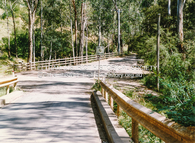
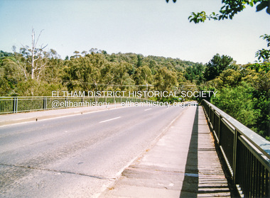
 Eltham District Historical Society Inc
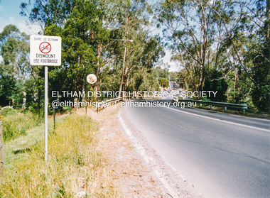
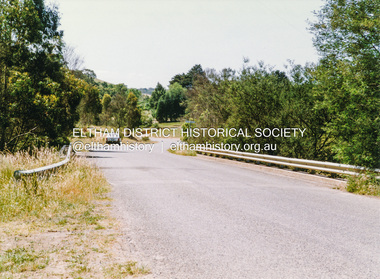
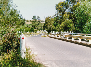
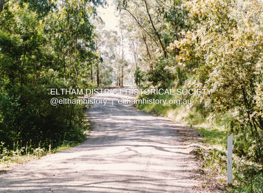
Photograph, Doug Orford, Bridge across Diamond Creek, Wattletree Road, Eltham North, 1991, 1991
From a collection of 35 photos taken by Doug Orford at 35 specific locations along the exact boundary of the then Shire of Eltham.Colour photographbridges, diamond creek, wattletree road, eltham north -
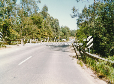
 Eltham District Historical Society Inc
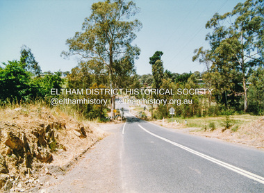
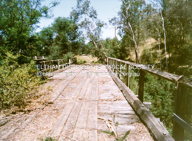
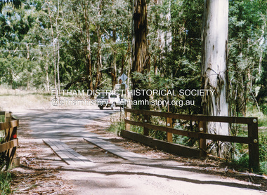
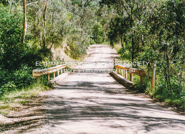
Photograph, Doug Orford, Bridge across Diamond Creek, Allendale Road, Eltham North, 1991, 1991
From a collection of 35 photos taken by Doug Orford at 35 specific locations along the exact boundary of the then Shire of Eltham.Colour photographbridges, diamond creek, eltham north, allendale road -
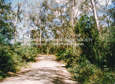
 Eltham District Historical Society Inc
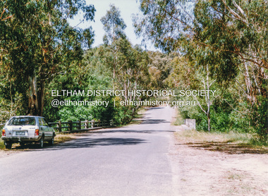
Photograph, Doug Orford, Ingrams Road, Research, near Allendale Road, 1991, 1991
From a collection of 35 photos taken by Doug Orford at 35 specific locations along the exact boundary of the then Shire of Eltham.Colour photographingrams road, research (vic.) -
 Eltham District Historical Society Inc
Photograph, Doug Orford, Lorimer Road, Research, near Reynolds Road, 1991, 1991
From a collection of 35 photos taken by Doug Orford at 35 specific locations along the exact boundary of the then Shire of Eltham.Colour photographresearch (vic.), lorimer road -
 Eltham District Historical Society Inc
Photograph, Doug Orford, Kangaroo Ground - Wattle Glen Road, Wattle Glen, near Reynolds Road, 1991, 1991
From a collection of 35 photos taken by Doug Orford at 35 specific locations along the exact boundary of the then Shire of Eltham.Colour photographkangaroo ground - wattle glen road, wattle glen -
 Eltham District Historical Society Inc
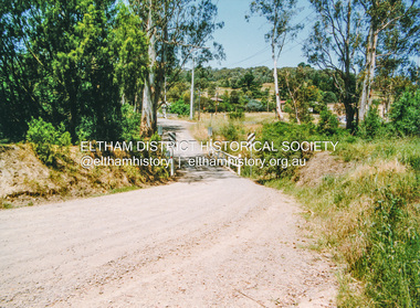
Photograph, Doug Orford, Bridge across Diamond Creek, Wilson Road, Wattle Glen, 1991, 1991
From a collection of 35 photos taken by Doug Orford at 35 specific locations along the exact boundary of the then Shire of Eltham.Colour photographwattle glen, bridges, diamond creek, wilson road -
 Eltham District Historical Society Inc
Photograph, Doug Orford, Monash Bridge across Diamond Creek, Hurstbridge - Arthurs Creek Road, Hurstbridge, 1991, 1991
From a collection of 35 photos taken by Doug Orford at 35 specific locations along the exact boundary of the then Shire of Eltham.Colour photographbridges, diamond creek, hurstbridge - arthurs creek road, hurstbridge, monash bridge -
 Eltham District Historical Society Inc
Photograph, Doug Orford, Burkes Bridge across Arthurs Creek, Hurstbridge - Arthurs Creek Road, Hurstbridge, 1991, 1991
From a collection of 35 photos taken by Doug Orford at 35 specific locations along the exact boundary of the then Shire of Eltham.Colour photographbridges, hurstbridge - arthurs creek road, hurstbridge, burkes bridge, arthurs creek -
 Eltham District Historical Society Inc
Photograph, Doug Orford, The old Burkes Bridge across Arthurs Creek, Hurstbridge - Arthurs Creek Road, Hurstbridge, 1991, 1991
From a collection of 35 photos taken by Doug Orford at 35 specific locations along the exact boundary of the then Shire of Eltham.Colour photographbridges, hurstbridge - arthurs creek road, hurstbridge, burkes bridge, arthurs creek -
 Eltham District Historical Society Inc
Photograph, Doug Orford, Lintons Bridge across Arthurs Creek, Doctors Gully Road, Nutfield, 1991, 1991
From a collection of 35 photos taken by Doug Orford at 35 specific locations along the exact boundary of the then Shire of Eltham.Colour photographbridges, arthurs creek, lintons bridge, nutfield, doctors gully road -
 Eltham District Historical Society Inc
Photograph, Doug Orford, Bridge across Arthurs Creek, Chapel Lane, Nutfield, 1991, 1991
From a collection of 35 photos taken by Doug Orford at 35 specific locations along the exact boundary of the then Shire of Eltham.Colour photographbridges, arthurs creek, chapel lane, nutfield -
 Eltham District Historical Society Inc
Photograph, Doug Orford, Bridge across Arthurs Creek, Arthurs Creek Road, Arthurs Creek, 1991, 1991
From a collection of 35 photos taken by Doug Orford at 35 specific locations along the exact boundary of the then Shire of Eltham.Colour photographbridges, arthurs creek, arthurs creek road -
 Eltham District Historical Society Inc
Photograph, Doug Orford, Bridge across Arthurs Creek, Eagles Nest Road, Arthurs Creek, 1991, 1991
From a collection of 35 photos taken by Doug Orford at 35 specific locations along the exact boundary of the then Shire of Eltham.Colour photographbridges, arthurs creek, eagles nest road -
 Eltham District Historical Society Inc
Photograph, Doug Orford, Bridge, Chads Creek Road, Strathewen, 1991, 1991
From a collection of 35 photos taken by Doug Orford at 35 specific locations along the exact boundary of the then Shire of Eltham.Colour photographbridges, chads creek road, strathewen -
 Eltham District Historical Society Inc
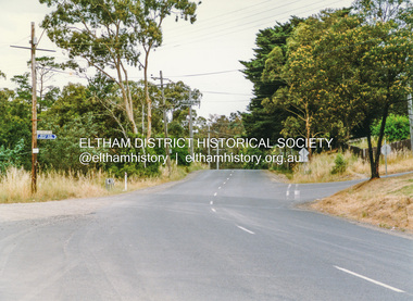
Photograph, Doug Orford, Heidelberg - Kinglake Road near Kinglake, 1991, 1991
From a collection of 35 photos taken by Doug Orford at 35 specific locations along the exact boundary of the then Shire of Eltham.Colour photographheidelberg-kinglake road, kinglake -
 Eltham District Historical Society Inc
Photograph, Doug Orford, Old Kinglake Road, Steels Creek, 1991, 1991
From a collection of 35 photos taken by Doug Orford at 35 specific locations along the exact boundary of the then Shire of Eltham.Colour photographold kinglake road, steels creek -
 Eltham District Historical Society Inc
Photograph, Doug Orford, Buttermans Track crossing Watsons Creek, Christmas Hills, 1991, 1991
From a collection of 35 photos taken by Doug Orford at 35 specific locations along the exact boundary of the then Shire of Eltham.Colour photographbuttermans track, watsons creek, christmas hills -
 Eltham District Historical Society Inc
Photograph, Doug Orford, Bridge across Watsons Creek, One Tree Hill Road, Christmas Hills, 1991, 1991
From a collection of 35 photos taken by Doug Orford at 35 specific locations along the exact boundary of the then Shire of Eltham.Colour photographwatsons creek, christmas hills, bridges, one tree hill road -
 Eltham District Historical Society Inc
Photograph, Doug Orford, Ford across Watsons Creek, Happy Valley Track, Christmas Hills, 1991, 1991
From a collection of 35 photos taken by Doug Orford at 35 specific locations along the exact boundary of the then Shire of Eltham.Colour photographwatsons creek, christmas hills, happy valley track -
 Eltham District Historical Society Inc
Photograph, Doug Orford, Bridge across Watsons Creek, Clintons Road, Christmas Hills, 1991, 1991
From a collection of 35 photos taken by Doug Orford at 35 specific locations along the exact boundary of the then Shire of Eltham.Colour photographwatsons creek, christmas hills, bridges -
 Eltham District Historical Society Inc
Photograph, Doug Orford, Bridge across Watsons Creek, Eltham - Yarra Glen Road, Watsons Creek, 1991, 1991
From a collection of 35 photos taken by Doug Orford at 35 specific locations along the exact boundary of the then Shire of Eltham.Colour photographwatsons creek, bridges, eltham - yarra glen road -
 Eltham District Historical Society Inc
Photograph, Doug Orford, Calwell Road crossing Watsons Creek, Kangaroo Ground, 1991, 1991
From a collection of 35 photos taken by Doug Orford at 35 specific locations along the exact boundary of the then Shire of Eltham.Colour photographwatsons creek, calwell road, kangaroo ground -
 Eltham District Historical Society Inc
Photograph, Doug Orford, Oxley Bridge crossing Watsons Creek, Henley Road, Kangaroo Ground, 1991, 1991
From a collection of 35 photos taken by Doug Orford at 35 specific locations along the exact boundary of the then Shire of Eltham.Colour photographwatsons creek, kangaroo ground, oxley bridge, henley road -
 Eltham District Historical Society Inc
Photograph, Doug Orford, Bridge across Yarra River, Kangaroo Ground - Warrandyte Road, Warrandyte, 1991, 1991
From a collection of 35 photos taken by Doug Orford at 35 specific locations along the exact boundary of the then Shire of Eltham.Colour photographbridges, yarra river, warrandyte -
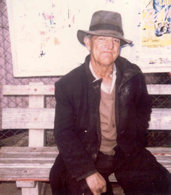 Tatura Irrigation & Wartime Camps Museum
Photograph, Harry Murray, 2001
Harry Murray, a keen Tatura Football Club follower, supported his team by running around the boundary for the whole match.murray, harry, football supporter, photograph, people -
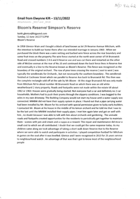 Whitehorse Historical Society Inc.
Document, Bloom's Reserve/Simpson's Reserve, 18/11/2022
Information regarding early Bloom's Reservenon-fictionInformation regarding early Bloom's Reservekift elwynne, reserve avenue mitcham no 29 -
 Halls Gap & Grampians Historical Society
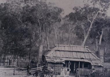
Photograph - B/W, c 1870
Jane and Samuel Delley emigrated to Australia in 1857. By 1870 they and their young family had settled in the area at the entrance of the Fyans Valley and on the west of Fyans Creek. There they built a home and recognising the needs of passing travellers and timber-getters, they established Delley's Inn, providing food and refreshments to all in need.Timber dwelling with bark roof and two chimneys, one at either side of the house. In front stand four men and two women with two wagon drays in the foreground. The area is enclosed by picket fencing close to the house and a rough timber fence on the rear of the boundary. Delley's Inn,1870 on reverse in pencilbuildings, houses, accommodation, delley's inn -
 Ringwood and District Historical Society
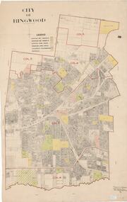
Map, City of Ringwood - Rateable Properties Layout - c.1966. Overlay showing Reserves, Open Space, Playgrounds, and Schools
A0-size (approx) map of named streets, lot-numbered properties and locality features within City of Ringwood boundary. Colour-coded legend identifying Existing Rec Reserves, Proposed Rec Reserves, Existing Open Space, Children's Playgrounds, and Schools.Scale: 8 chains to 1 inch. Map picked up in Engineer's office at old town hall prior to demolition 1971.