Showing 931 items
matching bridge building
-
 Glenelg Shire Council Cultural Collection
Photograph - Photograph - Portland Harbour Trust - New store building and workshop area 23/2/53, 1953
Port of Portland Authority archivesFront: NEW STORE BUILDING AND WORKSHOP AREA 23/2/53/ View from Cliff St. Bridge. (lower centre) Back: P.H.T./ Print No. 3/9 Neg. No 142/ Date taken 23.2.53./ SUBJECT./ % (Ink stamp with blue pen and pencil additions, centre)port of portland archives -
![Photograph - Digital image, House St Helena and Diamond Creek Roads [Greensborough], 02/05/2013](/media/collectors/4f729f5697f83e03086015b8/items/5729bbd22162f108e8de5be2/item-media/5729bc112162f108e8de617d/item-fit-380x285.jpg) Greensborough Historical Society
Greensborough Historical SocietyPhotograph - Digital image, House St Helena and Diamond Creek Roads [Greensborough], 02/05/2013
These photographs of the house on the corner of St Helena and Diamond Creek Roads was taken in 2013 to show changes over 40 years, based on Ron Reynold's sketches in the 1973 publication 'Greensborough and Greenhills' published by Cypress Books... which states "Built on a steep hill in a bush setting in the early 1920s, for a Dr Wood, the weatherboard house now overlooks an area of activity and change. The owners, Mr and Mrs E. 'Bluey' Blackburn, remember when their 3/4 acre building block dropped to the edge of a dirt road. Today the view from the high verandah encompasses the Main Street shopping centre, new and old bridges, new roads and houses, the Plenty River, natural bush, hills and sports grounds."Digital copy of colour photograph.greensborough and greenhills, st helena road greensborough, diamond creek road greensborough, wood family, ron reynolds -
![Photograph - Digital image, Kelly Garden Supplies [Greensborough], 02/05/2013](/media/collectors/4f729f5697f83e03086015b8/items/5729bced2162f108e8de6b52/item-media/5729bd212162f108e8de74aa/item-fit-380x285.jpg) Greensborough Historical Society
Greensborough Historical SocietyPhotograph - Digital image, Kelly Garden Supplies [Greensborough], 02/05/2013
This photograph of the former site of Kelly Garden Supplies was taken in 2013 to show changes over 40 years, based on Ron Reynold’s sketches in the 1973 publication “Greensborough and Greenhills” published by Cypress Books. The site is now part of the Civic roundabout at the top of the Greensborough By-pass. Civic Drive was associated with the building of Diamond Valley Council Offices opened by Governor Rohan Delacombe on 26/2/1972. Previously it was known as Kelly's Track which wound its way around to a house that overlooked the aqueduct bridge. Kelly's Sandpit (quarry) was the local go to place to obtain road, driveway fill and red sand for local construction. For 80 years previous Kelly's quarry supplied sand to the greater Melbourne area for the surfacing of school grounds, parks etc. Digital copy of colour photograph.greensborough and greenhills, civic drive greensborough, kelly garden supplies, ron reynolds -
 Glenelg Shire Council Cultural Collection
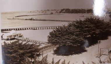
Postcard - Postcard - The Harbour, Portland, n.d
Black and white photographic image of a harbour with two long piers running into it and a shorter jetty with a building on it and circular jetty protruding from it. In the foreground are trees, a dirt road with an RACV sign bridging it to the foreground right and a railway track visible between the trees.Front: THE ROSE SERIES P. 10771/ COPYRIGHT (typed, lower left) THE HARBOUR, PORTLAND (typed, lower centre) -
Glenelg Shire Council Cultural Collection
Photograph - Photograph reprint of a scan of a photograph - Bridge Inn at Casterton (1906 flood), Victoria, n.d
Vern McCallum CollectionReprint of a scan of a black and white photograph. Image shows Bridge Inn, in centre, surrounded by Hoodwaters, as are all other buildings in this photo. Print mounted on a white archival mount board frame. -
Glenelg Shire Council Cultural Collection
Photograph - Sheet of 12 contact prints of rephotographed photographs - Various Portland land marks, c. 1970
Sheet of 12 contact prints of rephotographed photographs. Identifying numbers 5725 a, b, c, d, e, f, g, h, i, j, k, l (a) Bentinck Street from sea (b) James Robertson store (c) Bentinck Street south from All Saints (d) Fawthrop Lagoon (e) Henty Beach Cliffs (f) Bridge over Salt Creek (g) Res. Dr. C. Grier, Julia Street (h) Group of men sitting/standing outside wooden building (i) Henty Woolstores, Julia Street (j) S.S 'Dawn' tied up to railway pier (k) All Saints Catholic Church (l) Cliffs at Henty Streetfrom the front: (b) James Robertson store (c) Bentinck Street, Portland - Nicholls (e) Cliffs above Henty Street (f) Bridge over Portland drain (i) Henty Woolstore and Observer buildings, Julia Street -
Glenelg Shire Council Cultural Collection
Photograph - Sheet of 12 contact prints - Various Portland and local surrounds buildings and landmarks, c. 1970
Sheet of 12 contact prints of rephotographed photographs: Identifying numbers 5721 a, b, c, d, e, f, g, h, i, j, k, l (a) Fishing party, flat rocks Bridgewater (b) Dutton Way (c) Julia Street (d) Steam train (e) Bentinck Street corner (f) Bridge across Salt Creek 'Kingsley' in background (g) Bentinck Street railway station from Customs House (h) Yankee Doodle corner (i) Picnic on banks of river (j) Henty Bay (k) Man holding two bikes Wellington Road/Bentinck Street (l) same as (h) - Bentinck Street railway station from Customs House -
Glenelg Shire Council Cultural Collection
Photograph - Sheet of 6 contact prints - Various Historic Portland buildings and landmarks, c. 1970
Sheet of 6 contact prints of rephotographed photographs: Identifying numbers 5709 a,b,c,d,e,f Measurements a,b, c, d, e, f,5 x 3.55 x 1.5 cm a. Harbour from Post Office b. Bridge in Gardens c. Gardens Cottage d. Yankee Doodle Corner e. Cape Nelson Road to Bentinck Street f. Percy Street -
Glenelg Shire Council Cultural Collection
Photograph - Sheet of 12 contact prints - Various historic Portland buildings and Landmarks, c. 1970
Sheet of 12 contact prints of rephotographed photographs. Identifying numbers 5726 a, b, c, d, e, f, g, h, i, j, k, l (a) S.S. 'Dawn' at Railway Pier (b) Macs Hotel (c) Dr. C. Grier, Res. Julia Street (d) Bentinck Street, South from All Saints (e) Captain James Fawthrop (f) Bridge over Salt Creek (g) 'Prospect' (h) 'Windsor Cottage' (i) Bentinck Street from sea (j) London Hotel (k) 'Greenmount' (l) British fleet at anchor in Portland BayFront: (b) Macs Hotel (l) British fleet in portland Bay, Sept 30 1891 CN-865-G -
 Halls Gap & Grampians Historical Society
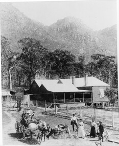
Photograph - B/W, C 1880
1880-1902 Land owned by Robert and Sarah Graham who owned a large portion of land best described as Upper Fyans Valley. At some time after 1880, they sold a parcel of the land under Sundial Peak to David Austin who built a slab hut. C1896, The land was sold to James and Amy Balmain which they named 'Bellfield' Amy was a daughter of John D/Alton who built the Stawell Water Supply System. Balmain purchased the vacant school cottage at Burnt Bridge and moved it to 'Bellfield' Over the next six years the house was enlarged to accommodate their growing family but sold in 1902 following the death of Amy Balmain.House with addition People leaving house by horse and carriage, people standing in groundsState Library Victoria, Rose's Australasian Views Victorian Series photographed and published by George Rose 123 Chapel St., Windsor, Victoriabuildings, houses, bellfield -
 Halls Gap & Grampians Historical Society
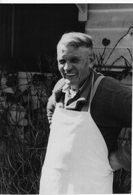
Photograph - B/W, C 1970s (?)
Robert Greer was the Hall's Gap baker. He married Ida Warren and they had a daughter Rae. Robert & Ida inherited the bakery from Ida's father John Warren who established the business in 1929. For further details see Bridging the Gap, p.56Photo shows man (Robert Greer) in an apron standing outside his house.people, greer, buildings, bakery -
 Halls Gap & Grampians Historical Society
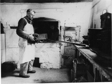
Photograph - B/W, C 1950s (?)
Robert Greer, baker, married Ida Warren whose family started the bakery; in 1929. Robert & Ida inherited the Bakery from Ida's father John Warren. for further information see Bridging the Gap p. 56Photo shows Robert Greer, baker standing with a load tin in his hands, inside the bakery. Baking tins & ovens can be seen in the photo.Folio no.48 Negative no.25people, greer, buildings, bakery -
 Halls Gap & Grampians Historical Society
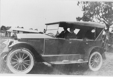
Photograph - B/W, C 1920 (?)
The woman in the photo is Ruth Pickering from Dadswell's Bridge.The photo shows a man and a woman seated in a car (Chevrolet ?). A building can be seen in the background.peopletransport, cars -
Halls Gap & Grampians Historical Society
Photograph - Photocopy, C 1925
The woman's name is Mavis Klauss and the boy is Arthur Klauss. The bridge is over the McKenzie Creek at Zumsteins. The Klauss family often camped in this area.The photo shows a woman and boy sitting on a bridge dangling their feet over a wide creek. A horse is teathered in the background on the left of the photo, where a building can also be seen.people, klauss, structures, bridges -
 Halls Gap & Grampians Historical Society
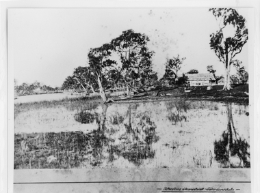
Photograph - B/W, c 1869
... "Bridging the Gap'. BUILDINGS Houses Photo shows bark roofed ...Photo is said to be of Schoolers' homestead,Lake Lonsdale. Miss Scouller was the teacher at Halls Gap Primary school in 1921.Spelling of Schooler varies from that on front of photo to 'Scouller' which appears in book "Bridging the Gap'.Photo shows bark roofed building on a bank of a body of water . A number of large gum trees surround the buildings-- tree reflections can be seen in the water. There appears to be extensive fencing around the buildings. The homestead is not visible.buildings, houses -
 Halls Gap & Grampians Historical Society
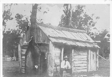
Photograph - B/W, c 1850s
... at the site later named the Borough Huts. See p8 Bridging the Gap ...This windowless bark hut would have been used by stockmen who looked after sheep and cattle in the Fyans Valley. This hut was situated at the site later named the Borough Huts. See p8 Bridging the Gap Photo shows a man sitting outside a wooden slab hut. The hut has a tin flashing along top roof line. Man is wearing a hat and tie. A gun is leaning up against wall of hut. A sheep or cattle race can be seen in left corner of photo. buildings, houses -
 Halls Gap & Grampians Historical Society
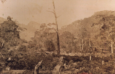
Photograph - Sepia, c 1876
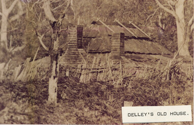
Photo is of Delley's home with the " Watchtower�" in the background. Further information see "Bridging The Gap" p13-14,17,22,54. Records 544 & 545 are enlarged portions of this photo.Photo shows old house to right side of photo. There are two chimneys and the lower half of the house is obscured by a stick fence and undergrowth. The mountain range can be seen faintly in the distance. A dead tree can be seen middle foreground. buildings, houses -
 Halls Gap & Grampians Historical Society
Photograph - B/W
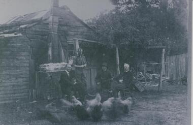
Fred Paasch was born in Denmark in 1862. It is unknown when he arrived in Australia or when he settled in Halls Gap. He owned land generally in the area now occupied by the Halls Gap Supermarket where he established an orchard. See " Bridging the Gap " p.58-60 "Victoria's Wonderland" p.98-99.Shingle and slab house, chimney has loose brick base and tin flue. Four men in foreground. Freddy Paasch, owner of the house is seated in the centre. A number of hens feed in the near foreground. A climbing rose coyers the fence and part of the house roof.buildings, houses, people, paasch -
 Halls Gap & Grampians Historical Society
Photograph - Sepia, C 1876
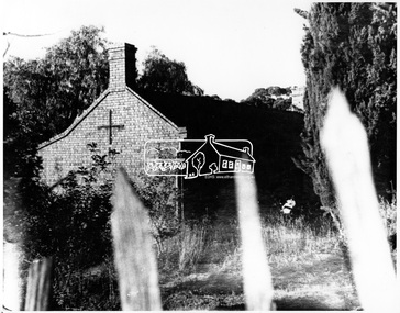
This is a photo of Delley's house. For further information see "Bridging The Gap" p13-14,17,22,54. This photo is an enlargement of a portion of Record 531.Photo shows old house. The roof is constructed of wooden slats held down by pieces of what appears to be fluming. There are two chimneys and the lower half of the house is obscured by a stick fence and undergrowth. There is a large tree in the foreground and another in the far right background. The house is surrounded by bush.buildings, houses -
 Halls Gap & Grampians Historical Society
Photograph - B/W
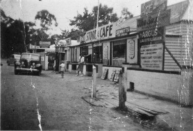
See 'Bridging the Gap' p65. Grampians Road Halls Gap.Group of shops with numerous advertising signs. A woman is leaving a shop, a young girl is standing in front of her. Two cars are parked in front of shops. Gravel road. Large gum trees in the background.buildings, shops -
 Eltham District Historical Society Inc
Negative - Photograph, George W. Bell, Excavation of site for new Eltham Shire Office building, 895 Main Road, Eltham, 1964
Black and white photograph of bulldozer excavating the former Shillinglaw Cottage site for new Shire Offices. 'Shillinglaw Trees' in background. The cottage and land were purchased by the Shire of Eltham as the site for a new shire office building. The cottage was destined for demolition but members of the community concerned at losing one of the areas earliest buildings (built c.1859) initiated a fund-raising campaign to save the cottage. In 1964 the cottage was dis-assembled, all the bricks numbered and reassembled several hundred meters to the south on a site between the Gahan house and the Eltham Railway Trestle Bridge (present-day Panther Place), which became known as the Eltham Common. The new shire offices at 895 Main Road were opened in 1965. Following the Kennett Government amalgamation of local government areas in 1994, the Shire of Eltham ceased to exist, and a new Shire of Nillumbik was created 15 December 1994 from the former Eltham shire and parts of the Diamond Valley shire. The former West Riding which included parts of Montmorency, Lower Plenty and Briar Hill were ceded to the new City of Banyule. Commissioners were appointed for several years and the new Council occupied the former offices of the Shire of Diamond Valley in Greensborough. The former Eltham Shire offices remained vacant until August 1996 the Commissioners suddenly elected to have the former Shire offices demolished immediately and the site has remained vacant ever since. It was not until 1997 before the community was allowed to democratically elect new Councillors to represent them. This photo forms part of a collection of photographs gathered by the Shire of Eltham for their centenary project book,"Pioneers and Painters: 100 years of the Shire of Eltham" by Alan Marshall (1971). The collection of over 500 images is held in partnership between Eltham District Historical Society and Yarra Plenty Regional Library (Eltham Library) and is now formally known as the 'The Shire of Eltham Pioneers Photograph Collection.' It is significant in being the first community sourced collection representing the places and people of the Shire's first one hundred years.Digital image 4 x 5 inch B&W Negeltham, eltham shire office, excavation, george w. bell collection, main road, municipal offices, shillinglaw cottage, shillinglaw trees, shire of eltham pioneers photograph collection, shire offices, significant tree -
 Eltham District Historical Society Inc
Negative - Photograph, George W. Bell, Shillinglaw Cottage, Main Road, Eltham, c.1964
Shillinglaw Cottage on its original site (present day 895 Main Road) showing old picket fence c.1964. The cottage and land were purchased by the Shire of Eltham as the site for a new shire office building. The cottage was destined for demolition but members of the community concerned at losing one of the areas earlist buildings (built c.1859) initiated a fund-raising campaign to save the cottage. In 1964 the cottage was dis-assembled, all the bricks numbered and reassembled several hundred meters to the south on a site between the Gahan house and the Eltham Railway Trestle Bridge (present-day Panther Place), which bcame known as the Eltham Common.This photo forms part of a collection of photographs gathered by the Shire of Eltham for their centenary project book,"Pioneers and Painters: 100 years of the Shire of Eltham" by Alan Marshall (1971). The collection of over 500 images is held in partnership between Eltham District Historical Society and Yarra Plenty Regional Library (Eltham Library) and is now formally known as the 'The Shire of Eltham Pioneers Photograph Collection.' It is significant in being the first community sourced collection representing the places and people of the Shire's first one hundred years.Digital image 4 x 5 inch B&W Negsepp, shire of eltham pioneers photograph collection, eltham, shillinglaw cottage, fences, george w. bell collection, houses, main road -
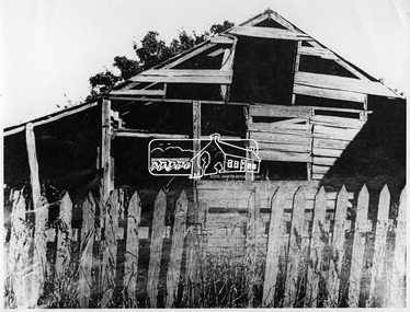 Eltham District Historical Society Inc
Negative - Photograph, George W. Bell, Sonny Hills Barn, corner of Susan and Bridge Streets, Eltham, c.1960
... photograph collection eltham sonny hills barn susan street bridge ...Demolished prior to 1970.This photo forms part of a collection of photographs gathered by the Shire of Eltham for their centenary project book,"Pioneers and Painters: 100 years of the Shire of Eltham" by Alan Marshall (1971). The collection of over 500 images is held in partnership between Eltham District Historical Society and Yarra Plenty Regional Library (Eltham Library) and is now formally known as the 'The Shire of Eltham Pioneers Photograph Collection.' It is significant in being the first community sourced collection representing the places and people of the Shire's first one hundred years.Digital image 4 x 5 inch B&W Negsepp, shire of eltham pioneers photograph collection, eltham, sonny hills barn, susan street, bridge street, farm buildings, george w. bell collection, picket fence, sonny hill -
 Eltham District Historical Society Inc
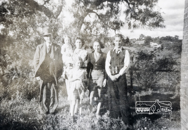
Photograph, Pa, Greta & family (perhaps Crozier?)
Photo depicts possibly a family group of six of various ages standing in bush setting with buildings in the background. Verso inscription: Pa, Greta & family Cnr Susan & Bridge [Streets]. Is this photograph relating to the Crozier Farm House? This was located at this site 66 Susan Street till 2007 when it was demolished by Nillumbik Shire Council. Black and white photograph printed with white borders (one of a set of five). -
 Eltham District Historical Society Inc
Photograph, Main Road, Eltham
Black and white photograph, looking south towards Bridge Street with A. Warren wood yard on left.a.r warren, timber yard, bridge street, d lyons, houses, buildings, shire of eltham -
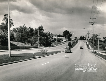
 Eltham District Historical Society Inc
Photograph, Peter Bassett-Smith, Construction of Eltham Community Centre, June 1977, 1977
The valley of Diamond Creek, Eltham looking south from Bridge Streeteltham, eltham community centre, buildings, construction -
 Eltham District Historical Society Inc
Photograph, Woodburn residence, mudbrick adobe (1949), Eltham Heritage Tour, 24 May 1992, 24/05/1992
ELTHAM HERITAGE TOUR The Society excursion on 24th May 1992 was arranged by David Bick, leader of the team carrying out the Shire's heritage study. David selected a number of sites or buildings identified in the study, some of them lesser known components of the Shire's heritage. The tour commenced at the Eltham Shire Office at 10.00 am. Travel was by private car and mini-bus with stops at about twelve locations for commentary by David.It included a short walk in Hurstbridge and lunch at Kinglake. Highlights of the tour included: - 10 am Leave from Shire Offices - 3 Important Trees - A Physical Link to Eltham's First Settlers - Toorak Mansion Gates - A Surviving Farm House - An Intact Circa 1900 Main Street - First Settlers - Gold Miners, and Timber-getters - An Early Hotel - A Pioneering Homestead - Changing Eltham Shire - 20th Century - 4 pm Afternoon Tea and Finish Tour Extract from ELTHAM CULTURAL HERITAGE TOUR (Newsletter No. 85, July 1992, by Bettina Woodburn) "In some respects Eltham is a 'back-water' and it has its own distinctive flavour. On the outskirts the homes date from the 1960's, 70's and 80s with a sprinkling of 'earth homes', mud-brick or pise, rammed dirt. Crossing Main Road into Beddoe Street and Thompson Crescent a very pleasant drive past pines and old fence lines, front lawns unfenced, the occasional ·old farm building, we eventually looked down on a huge circular roof of a 1992 adobe home. Other distinctive places included the Pauline Toner Butterfly Reserve, Gordon Ford's splendid garden at Fulling in Pitt Street, cypress hedges and old houses in Bridge Street and in every direction Eltham's special feature - a totally treed horizon. We were now in the part of the Shire closest to Melbourne - Montmorency - not on the way to anywhere, with no through road going across it, developed in the 1950's and 1960's with conventional gardens, now converted to native plants. The rail looped between Greensborough and Eltham and a shopping street (Were Street) served the area, growing up the hill from the station. It was a typical outer Melbourne suburb with lawns and roses with patches of originality. The shopping precinct still has 1950 characteristics - walls which sloped back, projecting roofs, the original shop fronts are nearly all tiled below the old windows. There's an air of past times about the School, the Dairy, the Butcher's (now a milk bar) and the Castlemaine stone face of the Commonwealth Bank. The final stop for the tour was at the mud-brick Woodburn residence, adobe of 1949 with additions. After War Service, Bill Woodburn had commenced an Architecture course at Melbourne University and after second year in the Christmas vacation, with his wife, Betti, built the two bedroom house - with amazing saving of costs. In the three and a half months they made over 3000 bricks (external walls 18" x 12" x 4", internal walls 12" x 9" x 4"), sifted top soil for mortar and laid them, on concrete foundations and slab floor, made all the structural window frames, door frames and roof members to carry 'super six' asbestos sheets, laboured for the electrician and plumber, did all the glazing and, still without electricity, moved in in March 1949. Rooms have been added, at first with glass walls, later using concrete blocks, to accommodate three daughters and a son. The house not only grew from the earth, but also with the family."Record of the Society's history and activities and highlighting various aspects of the Heritage Study undertaken by David Bick used to create the future heritage overlay for the Shire of Eltham and later Nillumbik Shire.Roll of 35mm colour negative film, 4 stripsKodak Gold 100 5095shire of eltham historical society, activities, heritage tour, woodburn house -
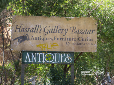
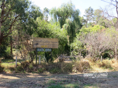 Eltham District Historical Society Inc
Photograph, Liz Pidgeon, Hassall's Gallery Bazaar, 1215 Main Road, Eltham, 25 March 2014, 25 March 2014
This is the site of the first roadside art gallery - Hassall's Roadside Gallery created by the artist son of an artist. Ian Hassall was the son of John Hassall who was among and may have been the first of the British poster artists. The gallery opened Saturday July 14, 1962 at 1215 Main road, Eltham by the director of the National Gallery of Victoria, Eric Westbrook. Situated on the left hand side of the main road, about a mile and a half beyond Eltham, towards Research, near Coleman's Corner at the intersection of Wattletree Road. The property has remnants of a stone quarry, probably for the purpose of gaining stone for local road making. Paintings were hung on screens and removed at night for safety. Large pedestals displayed sculpture and jewellery. All types of hand made art work was displayed. Access to the exhibition and grounds was slightly lower than the level of the road. They were encircled by a narrow little moat formed by a small tributary of the Diamond Creek accessed by a small well built stone bridge built by Ian Hassall with local stone. The Gallery later became known as Hassall's Gallery Bazaar antiques, furniture, curios bought and sold. It operated through to the early 1990s. The property has been derelict and neglected for some years. At one stage a shipping container sat near the entrance. This series of ten photographs illustrate the extent of the vegetation which has taken over the land, evidence of rubbish and a possible fire. In July 2017, planning permission was sought from the Shire of Nillumbik for buildings and works to construct a dwelling and associated vegetation removal. (source planningalerts.org.au)Born Digitaleltham, main road, hassall's gallery bazaar -
 Eltham District Historical Society Inc
Photograph, Liz Pidgeon, Hassall's Gallery Bazaar, 1215 Main Road, Eltham, 25 March 2014, 25 March 2014
This is the site of the first roadside art gallery - Hassall's Roadside Gallery created by the artist son of an artist. Ian Hassall was the son of John Hassall who was among and may have been the first of the British poster artists. The gallery opened Saturday July 14, 1962 at 1215 Main road, Eltham by the director of the National Gallery of Victoria, Eric Westbrook. Situated on the left hand side of the main road, about a mile and a half beyond Eltham, towards Research, near Coleman's Corner at the intersection of Wattletree Road. The property has remnants of a stone quarry, probably for the purpose of gaining stone for local road making. Paintings were hung on screens and removed at night for safety. Large pedestals displayed sculpture and jewellery. All types of hand made art work was displayed. Access to the exhibition and grounds was slightly lower than the level of the road. They were encircled by a narrow little moat formed by a small tributary of the Diamond Creek accessed by a small well built stone bridge built by Ian Hassall with local stone. The Gallery later became known as Hassall's Gallery Bazaar antiques, furniture, curios bought and sold. It operated through to the early 1990s. The property has been derelict and neglected for some years. At one stage a shipping container sat near the entrance. This series of ten photographs illustrate the extent of the vegetation which has taken over the land, evidence of rubbish and a possible fire. In July 2017, planning permission was sought from the Shire of Nillumbik for buildings and works to construct a dwelling and associated vegetation removal. (source planningalerts.org.au)Born Digitaleltham, main road, hassall's gallery bazaar