Showing 273 items
matching campus map
-
 University of Melbourne, Burnley Campus Archives
Plan, Aberfeldie, Trawalla, 1905
Photocopies of plans of 2 adjoining house and garden sites in Toorak, Victoria, 'Aberfeldie' and 'Trawalla'. Handwritten, "Map 937a, Map 937b 'Trawalla', Map 937c, Map 937d."aberfeldie, trawalla -
University of Melbourne, Burnley Campus Archives
Plan, Maplist: Catalogue of Victorian maps, 1984
Brochure showing all standard series mapping in Victoria available from Map Sales Centre as at October 1984. Includes: Geographic, Geological Planimetric, Aerial Photography, Photo Maps. -
University of Melbourne, Burnley Campus Archives
Plan, Merri Creek Management Committee, c. 1990
(1) 2 sets Base Maps Scale 1:5000 MCMC. (2.) 2 sets Merri Creek remnant vegetation Scale 1:5000.merri creek, management plan -
University of Melbourne, Burnley Campus Archives
Booklet - Brochure, Historic Cooktown Botanic Gardens
botanic garden, cooktown, map, plants -
University of Melbourne, Burnley Campus Archives
Plan (Item) - Burnley Gardens, Map 2. Existing Conditions
Annotations in ink and pencil on 1 copy of 5 -
University of Melbourne, Burnley Campus Archives
Book - Register, The Orchard at Burnley Gardens, 22.05.1955
No. 237 handwritten. No. 01310H Norman Bros. Pty. Ltd. 60-62 Elizabeth St., Melbourneorchard, field station, history, fruit tree blocks, planting plans, newspaper cutting, red delicious apple, preston prolific fig -
University of Melbourne, Burnley Campus Archives
Book, Orchard, 1955-1959
No. 01310H Norman Bros. Pty. Ltd. 60-62 Elizabeth St., Melbourneorchard, field station, history, fruit tree blocks, planting plans, newspaper cutting, red delicious apple, preston prolific fig -
University of Melbourne, Burnley Campus Archives
Plan - Photocopy, Keilor Planning Scheme, 1993
Photocopies. 18.02.1993. (1) 5 copies Map user guide - Keilor Planning Scheme, List of Zones Reservations and additional Planning Controls. (2) Keilor Planning Scheme - Local Section. Zones and Reserved Land Map No. 7. (3) Map No 9. Also 3 photocopies of maps joined together. Used in planning Native Garden Woodland Section.keilor, native garden, reservations -
University of Melbourne, Burnley Campus Archives
Plan - Photocopy, Sunshine Planning Scheme, 1993
Photocopies. 18.02.1993. (1) 5 copies Map User Guide - Sunshine Planning Scheme. List of Zones, Reservations and additional Planning Controls. (2) Sunshine Planning Scheme - Local Section. Zones and Reserved Land Map No 2. (3) Map No 3. (4) Map No 4. Used in planning Native Garden Woodlandsunshine, reservations, native garden -
University of Melbourne, Burnley Campus Archives
Plan, Grace Park Feature Plan, 1901-1983
(1) City of Hawthorn plan dated August 1983. Drawing No P12/24 Sheet 1 of 1. Surveyed: L.B. & H.K. Traced H.K. Scale 1:500. (2) Photocopy of map of area, Grace Park coloured in. 1901 handwritten on page.hawthorn, grace park -
University of Melbourne, Burnley Campus Archives
Map, City of Ringwood, c.1895
(1) Coloured map with Reserves, Council (other than Reserves) and Schools by City Engineer, c1985. (2) 10 copies. (3) Tracing paper copy.ringwood, gardens -
University of Melbourne, Burnley Campus Archives
Plan, Yarra 500/045.043 Municipalities of Prahran 211 and Richmond 207, 1979
Melbourne and Metropolitan Board of Works Series 1:500. Map prepared by the Survey Division, MMBW January 1979. Scale 1:500. Area surrounding Heyington Station and St. Kevin's Junior Schoolmelbourne and metropolitan board of works, prahran, richmond -
University of Melbourne, Burnley Campus Archives
Map, Hawthorn, 1981
Map of Hawthorn with legend of principal buildings. Shows council ward boundaries. Amended several times between 17/9/1958 (P. Linford) and 14/7/81hawthorn, buildings, p. linford, hawthorn council wards -
University of Melbourne, Burnley Campus Archives
Map, Melbourne and Metropolitan Board of Works Plan No. 42 Richmond, c.1884-1891
Photocopy of Melbourne and Metropolitan Board of Works Plan No 42 M 387 ₍₄₂₎ of Richmond from plans dated c1884-1891. Shows A. Lynch's Plan of the Gardens. Scale 160 ft. to 1 inchOriginal stamped "Original Plan Room"melbourne and metropolitan board of works, richmond, burnley gardens, richmond park -
University of Melbourne, Burnley Campus Archives
Map, Kosciusko Primitive Area, Vegetation & Associated Features, 1972
2 copies of map dated 1972 by Division of Plant Industry, Commonwealth Scientific and Industrial Research Organization. Shows: General Vegetation Approximately 2,000 feet-7,000 feet; and Alpine and Subalpine Complex Approximately 5,000 feet-7,000 feet. Scale 1:31,680.vegetation, mount kosciusko area, alpine vegetation, d.j. wimbush, r.t. morland -
University of Melbourne, Burnley Campus Archives
Map - Geological map, Melbourne and Suburbs, 1959
Geological map of Melbourne, 1959, modified by officers of the Geological Survey of Victoria, from earlier geological surveys. Scale 1:31.680melbourne metropolitan area, geology, geological survey of victoria, department of mines -
University of Melbourne, Burnley Campus Archives
Map, Melbourne Metropolitan Planning Scheme, c. 1978
Maps showing Zones and Reservations in the Merri Creek area of Melbourne, prepared by the Drafting Department, Planning Branch, MMBW. (1) Map No 36, coloured. (2) Map No 37, coloured. (3) Map No 38, not coloured. (4) Map No 46. Scale 1:9600. May have been used in planning the Native Garden Woodland Area. merri creek, melbourne and metropolitan board of works, melbourne metropolitan area -
University of Melbourne, Burnley Campus Archives
Map, Photo Mapping Services Pty. Ltd, Burnley College Burnley Gardens, 1995
HistoricalMap compiled by Photo Mapping Services Pty. Ltd., using aerial photography, dated 9th July, 1995. (1) Coloured proof. Scale 1:500. Aerial views, with and without trees marked, of Burnley Gardens: (2) Map with trees (3) Map without trees, sections numbered but no legend.burnley college, gardens, trees -
University of Melbourne, Burnley Campus Archives
Map, Yarra 2500/09.12, c. 1980
Copy of portion of Melbourne and Metropolitan Board of Works Map Series Yarra 1:2500/ 09.12, showing Yarra River, Kew area.melbourne and metropolitan board of works, kew, yarra river -
 University of Melbourne, Burnley Campus Archives
Plan, Master Plan Burnley Gardens, c.1996
Plan of Burnley Gardens showing P.R.I. (Plant Research Institute) and V.C.A.H. Buildings and Open Space areas. Map used - photogrammetric plot prepared for the V.C.A.H. By Stereometric Services from aerial photography taken 10-7-1988.vcah, burnley gardens, stereometric services, master plan -
University of Melbourne, Burnley Campus Archives
Plan, V.C.A.H Burnley Location map, c.1991
Plan of the Campus with buildings named.vcah, burnley campus -
University of Melbourne, Burnley Campus Archives
Plan, Classroom Locations Map, 1990-2000
Plan produced by VCAH Burnley with classrooms marked.vcah, burnley -
University of Melbourne, Burnley Campus Archives
Plan, [Historical Maps of Richmond Park], 1862-2000
(1) Proposed reserve for Horticultural & Experimental Garden in the Survey paddock Richmond. R.19A (1865). Shows Swan Street Extension. Gazettals 1877, 1887. (2) As (1). Half of map only Annotation by A. Purchas, 9 October, 1862. (3) Plan of Richmond park. A.L. Martin Authorised Surveyor, 31st August, 1872. [Dept. of lands & Survey Melbourne, J. Noone, 6th September 1872.] Map in 4 sheets. (4) Richmond Park. Surveyed by Geo. Black, Authorised Surveyor 13.8.91 (2 copies). (5) [Richmond Park] Shows road alignments gazetted 1871 & 1881 (part copy only - Neg. 18375). (6) City of Richmond Parish of Jika Jika County of Bourke. Department of lands & Survey, 1919 (annotations i.e. Melb. City Link, Amrad, etc. to 1994.) (7) Burnley gardens, 2000. Produced by P. Tulk, Institute of Land & Food Resources, Burnley College, 2000 (re area proposed for heritage listing.)richmond park, survey paddock -
University of Melbourne, Burnley Campus Archives
Map, Plan of Early Melbourne Showing Original Crown Allotments, c. 1852
Copy of 'Map of the City of Melbourne, and its Extension, together with Collingwood, Richmond, Hawthorne, the Emerald Hill, and a portion of Prahran Compiled from the Government Plans and Private Survey by William Green.' (2 copies, one enlarged)melbourne, william green, richmond, hawthorne, collingwood -
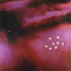 Federation University Art Collection
Artwork, other - Artwork, 'Ghosts in the Himalayas (Shot Up)' by Lisa Anderson, 2016
Dr Lisa ANDERSON (1958- ) Dr Anderson’s research questions environmental issues that impact on the social structures of communities and their mapped or metaphysical borders. She develops projects around ways of understanding the effects of climate change. These include work with folklore, legends and religions that tell stories of coping with weather, forced migration of animals and people and coping with difference. She has undertaken international residency programs and exhibitions in the Arctic, Iceland, Paris, Norway, London and China, and she was the first Artist in Residence at the Australian Museum. These unique opportunities continue an extensive art practice of installation work, video, photography and sculpture. Anderson has an extensive record of exhibitions in Australia and overseas with work included in both private and corporate collections. Her exhibitions include Journeys: Due North, a large installation work that includes work created over a 10-year period of engagement in expedition and science work North of the Arctic Circle. Beneath the Beauty of Architecture, an exhibition at her London Gallery, Bicha, used images created in China, Nunuvut Territory in Canada and the Antarctic while working with the migration stories of survival. Dr Anderson has created many large scale artworks that challenge notions of occupation of the City, including Writing the City, a three-year program of installation works to shift the use of Sydney to being a city of public space in its pre-Olympic development. Singing up Stones celebrated the people who created and use the Opera House and the Quay for performance and ideas. This included the first image projection onto the Sydney Opera House, a projection onto the Sydney Harbour Bridge and a ballet of cruise liners with the sound simulcast on the local radio station. Two digital prints with acrylic on metal and bullet holes. This work is the result of research on the hidden voice of landscape undertaken by Dr Lisa Anderson while an Honorary Professor at Federation University Australia. lisa anderson, available -
University of Melbourne, Burnley Campus Archives
Pamphlet (Collection), Pamphlets: Bachelor of Applied Science (Horticulture); Graduate Diploma in Horticulture; Associate Diploma in Horticulture
vcah, burnley college of horticulture, diploma of horticulture, bachelor applied science (horticulture), graduate diplomavcah, burnley college of horticulture, diploma of horticulture, bachelor applied science (horticulture), graduate diploma -
University of Melbourne, Burnley Campus Archives
Map (item) - Geological map, Geological map of Melbourne & suburbs. Issued by the Department of Mines, Victoria, 1937
-
University of Melbourne, Burnley Campus Archives
Map (item), Proposed Reserve for Horticultural & Experimental Garden in the Survey Paddock. Clement Hodgkinson Deputy Surveyor General, 1862
horticultural & experimental garden, survey paddock, clement hodgkinson -
University of Melbourne, Burnley Campus Archives
Map - Photocopy, University of Melbourne, c. 1999
Photocopy of enlargement of part of Map 2B, University of Melbourne, Parkville Campus, from Melway Street Directory. On part of page showing Brighton, Hampton, Sandringham, etc.university of melbourne, parkville campus, brighton, hampton, sandringham, melbourne -
University of Melbourne, Burnley Campus Archives
Map - Photocopy, La Trobe University Bundoora Campus, 2000
... University Bundoora Campus Map Photocopy ...2 photocopies and 1 enlarged photocopy of map reproduced from Melway Street Directory, Edition 29, of La Trobe University Bundoora Campus.la trobe university, bundoora campus