Showing 6843 items
matching central
-
 Ringwood and District Historical Society
Cuttings, Waverley Offset Publishing, Newspaper supplement including information on Ringwood and aerial map of Ringwood Central - c.1960, c.1960
Used to promote Ringwood shopping centre and amenities, with the newspaper promoting a big future.1. Newspaper Supplement - bifold about Ringwood Aerial Map of Ringwood Central - inset photo of Mayor; 2. Two pamphlets bifold. +Additional Keywords: Smart, Gerald (Mayor) / Clarke, B.G. (Mayor) / Gazzard, Clarke (Town Planner)'Ringwood a Big Future' -
 Whitehorse Historical Society Inc.
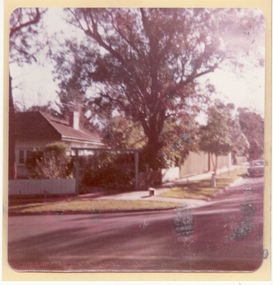
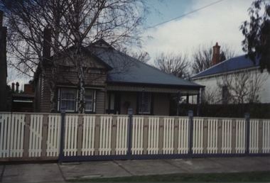
Photograph, 93 Central Road, Blackburn - View -3
Colour photograph of the house at 93 Central Road, Blackburn, purchased from William Elliott Wilson, by the Rev. John Flynn of the Australian Inland Mission, for his sister Rosetta Flynn in 1928. Photo shows view of house from street.central road, blackburn, no.93, wilson, william, elliott, flynn, rev. john, rosetta -
 Mission to Seafarers Victoria
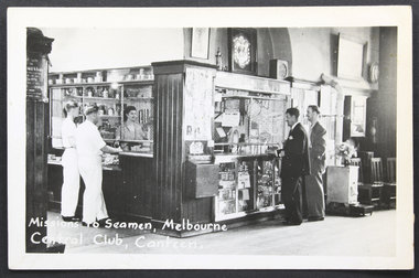
Postcard - Postcard, Black and white, KODAK, The Mission to Seamen, Melbourne - Central Hall, Canteen, mid 20th Century
One of a series of Mission to Seamen postcards produced in the immediate post-war and post WW2 period. Visual record of the club area of Mission to Seafarers, 717 Flinders Street, Melbourne mid 20th C.Black and white gloss postcard depicts the canteen situated in a corner of the central club space. Shows two seafarers in white uniform at one counter and two men in lounge suits at the other. . Note: Possible heater at far right of picture frame.Printed on back: 'POST CARD/CORRESPONDENCE ADDRESS ONLY/' . Stamp location is top right and is indicated by the word 'KODAK' on four sides.mission to seafarers, mission to seamen, seamen's mission, canteen, central hall, club, shop, heater, chairs, seamen, sailors, merchandising, letterbox, photographs, paintings, volunteers, lady, lhlg, shield, football -
 Ballarat Tramway Museum
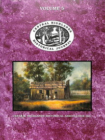
Book, Alan Bradley, "Law and Order on the Trams" - CHHA Journal, Oct. 1998
Four page article titled "Law and Order on the Trams" contained within the Central Highlands Historical Association Journal No. 5, written by BTM Board Member, Alan Bradley, accompanied by 5 photographs of Ballarat operations: p26 - street scene of Sturt St. and Grenville St. intersection prior to 1923, p31 - 2 half page photographs by David Endacott of last trams to Sebastopol - 19/10/1971 and on rear cover, two colour photos of trams taken during the last months of operations, from collection of David Endacott. No. 11 at Sturt St. - City terminus and No. 30 in Lydiard St. Nth. outside Art Gallery. Journal is 64 pages, with card covers, perfect bound, with articles, contents listing, index and various listings of CHHA members, book reviews, research in Progress. Has colour covers. Added to worksheet file - printed original of article - 7No. A4 sheets.trams, tramways, tramway closure, law and order, police, ballarat tramways -
 Mission to Seafarers Victoria
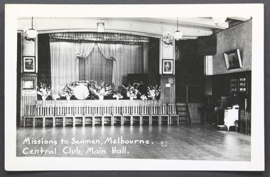
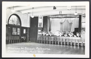
Postcard - Postcard, Black and white, KODAK, The Mission to Seamen, Melbourne - Central Hall, Main Hall, c. 1950
One of a series of Mission to Seamen postcards produced in the immediate post-war and post WW2 period. Visual record of the club area in the 1950s (before Queen Elizabeth's coronation) ready for the dances.Black and white gloss postcard depicts the central club space facing stage with flowers on stage, a drum kit and a piano. Curtained backdrop with sixteen chairs in front of the proscenium. Shows dance floorboards. Note: Possible heater at far right of picture frame.Printed on back: 'POST CARD/CORRESPONDENCE ADDRESS ONLY/' . Stamp location is top right is indicated by the word 'KODAK' on four sides.stage, curtains, mission to seafarers, seamen's mission, main hall, dancing, events, concerts, band, flowers, drums, piano, paintings, royal portraits, flinders street, melbourne, mission to seamen, wood floor, writing room, heater, stairs, chairs, king george vi, queen mother -
 Victorian Aboriginal Corporation for Languages
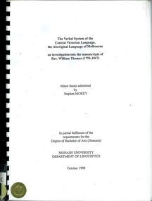
Thesis, Stephen Morey, The verbal system of the Central Victorian language, the Aboriginal language of Melbourne : an investigation into the manuscripts of Rev. William Thomas (1793-1867)
This thesis examines and analyses the linguistic data in the papers of the Reverend William Thomas (1793-1867) in the Mitchell Library, Sydney (Thomas MS 214). This data was found to refer mainly to the Aboriginal language of the Melbourne area, described by Blake and Reid (1998) as the Central Victorian Language.word listswathawurrung, wathaurong, boonwurrung, boon wurrung, woiwurrung, thagungwurrung, djadjawurrung, tjapwurrung, wergaia, wemba baraba, wemba wemba, yeti, madhi madhi, ledji, wadi, nari nari, wimmera, ballarat, bacchus marsh, gippsland, mount gambier, wonnin, john green, george augustus robinson, r h mathews, luise hercus, linguistics, sociolinguistics -
 Stawell Historical Society Inc
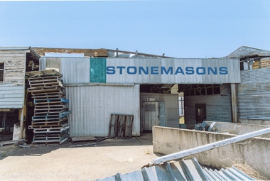
Photograph, Carol Ann Jones, Stonemasons on the corner of Main and Napier Streets, next to Central Park Stawell -- 6 Photos -- Coloured
4 Colour photographs showing stonemasons buildings in Lower Main street on corner of Napier Street Stawell. On corner of Central Park prior to demolition One photo shows headstones and pallets. Business established in 1864. Demolished March 2018. -
 Bendigo Military Museum
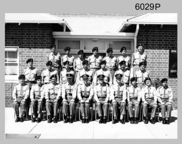
Photograph - Central Comd Fd Svy Unit at the Army Survey Regiment, 1966
This photograph of the Central Command Field Survey Unit, Field Survey Detachment was taken in front of the Survey building at Keswick Barracks in Adelaide, South Australia c1966. DR Ridge (later LTCOL) front Centre, SPR RJ Hayden top Right.This is a photograph of the C Comd Fd Svy Unit at the Army Survey Regiment, Bendigo. The photograph was printed on photographic paper and is part of the Army Survey Regiment’s Collection. The photograph was scanned at 300 dpi. .1) Photo, black & white 1966. Front Row to L to R: 5th MAJ Don Ridge. All other personnel are unidentified..1 - “C Comd Fd Svy Unit 1966” annotated on backroyal australian survey corps, rasvy, army survey regiment, army svy regt, fortuna, asr -
 Mission to Seafarers Victoria
Postcard - Postcard, Black and white, KODAK, The Mission to Seamen, Melbourne - Central Hall, Main Hall, c. 1950 (pre 1952)
One of a series of Mission to Seamen postcards produced in the immediate post-war and post WW2 period.Visual record of the club area of Mission to Seafarers, 717 Flinders Street, Melbourne in the 1950s (before Queen Elizabeth's corporation) ready for the dances.Black and white gloss postcard depicts the central club space. Taken facing stage with flowers on stage, a drum kit and a piano. Curtained backdrop with sixteen chairs in front of the proscenium. Shows dance floorboards and fan-shaped window above doorway on far left wall.Printed on back: 'POST CARD/CORRESPONDENCE ADDRESS ONLY/' . Stamp location is top right and is indicated by the word 'KODAK' on four sides.club, stage, mission to seafarers, seamen's mission, mission to seamen, main hall, dancing, events, curtains, royal portraits, king george vi, drums, piano, chairs, music, band -
 Ballarat Heritage Services
Photograph - Photograph - Colour, 10 Raglan Street North, Ballarat Central
Raglan Street is located within the heritage precinct of central Ballarat. This house was built around the turn of the century, with sewerage being added in 1908. The hallway is lined with pressed metal, the remainder of the metal being used at Talbot Hall. The building was occupied by Dr Pern.Postcard size colour photo of a weatherboard house in Raglan St Ballarat.raglan street, ballarat, house, garden, architecture -
 Greensborough Historical Society
Map, Melbourne and Metropolitan Board of Works. Survey Division, MMBW, Yarra 2500 / 17.27. Central Hurstbridge, 1978_02
Melbourne and Metropolitan Board of Works. Yarra 2500 [base map] 17-27. Central Hurstbridge. Parish of Greensborough 2724, Municipalities of Diamond Valley 257, Eltham 238 and Whittlesea 239. Prominent streets include: Anzac Avenue and Hurstbridge-Arthurs Creek Road. MMBW Map in 1:2500 [scale] series. Cream parchment with green tape reinforcing on edges and punched holes on left edge.mmbw, melbourne and metropolitan board of works, shire of diamond valley, hurstbridge - maps -
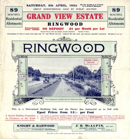 Ringwood and District Historical Society
Flyer, Subdivisional Land Auction Sale Brochure, Grand Central Estate, Ringwood, Vic. - 1924
Refer also to Reg. No. 5148 for 1925 auction sale of land also titled Grand View Estate situated further south in Ringwood.Double sided multi-folded page advertising public auction sale on Saturday, 5th April, 1924, of residential allotments highlighting local facilities, services and layout of the estate. Includes panoramic view over the estate and other local photographic images.Subdivision includes Whitehorse Road, Rupert Street, Herbert Street. and Leonard Street. Agents - Knight & Harwood, 315 Collins Street, Melbourne, Phone 10615, 10616 Central, in conjunction with J.B. McAlpin, Opposite Railway Station, Ringwood. Phone Ringwood 7. -
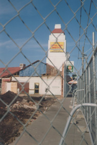 Lakes Entrance Historical Society
Photograph, Judy Davies, Central Hotel Lakes Entrance Victoria, 1/05/2005 12:00:00 AM
Colour photograph taken during demolition of western end of the Central Hotel looking towards tower along barricaded part of footpath on Esplanade Lakes Entrance Victoria. Also two colour photographs taken during demolition and a third colour photograph showing the rebuild prior to painting of exterior buildings, hotels -
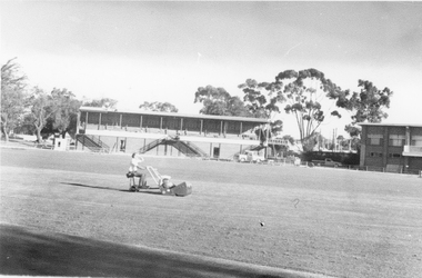 Stawell Historical Society Inc
Photograph, Central Park Oval c 1980
c 1980 Parks and garden staff mowing Central Park Oval. No 2 Grandstand has its roof on. Also at the right end of the Grandstand is the Railway foot bridge which was demolished in 1991.. The Football Clubrooms built in mid 1960's is just in view on the right side. Photo of oval with garden staff mowing. No 2 Grandstand and just a section of the Football Clubhouse in view. c 1980'sstawell sports -
 Surrey Hills Historical Society Collection
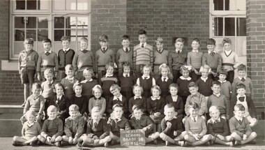
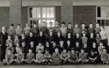
Photograph, Mont Albert Central School Grade 1B, 1953, 1953
Mont Albert State School was officially opened on 23rd April 1917. The school became Mont Albert Central School in 1918, taking in Forms 1 and 2. The school remained a Central School until 1964, when the secondary years formed the basis of a new High School, the Box Hill North High School, later to be named Koonung Secondary College. This is part of a large collection of material related to the Deakin, Mair and Young families, all with connections to Surrey Hills and Mont Albert. Laurie Young was the daughter of Beryl Mair (1916-1976) and Ernest Lance Young (1915-1999). The family lived at 5 York Street and later 11 York Street, Mont Albert. Laurie was born on 18 August 1947. Black and white class photo taken outside the school building. The class of 14 girls and 29 boys. Not all children are wearing school uniform."LY" in grey lead pencil in top RH corner. This probably stands for Laurie Young. Photographer's identification stamp in black ink " L.E. REYNOLDS / PHOTOGRAPHER / 38 RUSSELL STREET, / SURREY HILLS, E10"mont albert central school, laurie young, laurie newton, education -
 Surrey Hills Historical Society Collection
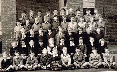
Photograph, Mont Albert Central School Grade 2B, 1954, 1954
Mont Albert State School was officially opened on 23rd April 1917. The school became Mont Albert Central School in 1918, taking in Forms 1 and 2. The school remained a Central School until 1964, when the secondary years formed the basis of a new High School, the Box Hill North High School, later to be named Koonung Secondary College. This is part of a large collection of material related to the Deakin, Mair and Young families, all with connections to Surrey Hills and Mont Albert. Laurie Young was the daughter of Beryl Mair (1916-1976) and Ernest Lance Young (1915-1999). The family lived at 5 York Street and later 11 York Street, Mont Albert. Laurie was born on 18 August 1947. Black and white class photo taken outside the school building. The class of 19 girls and 29 boys. Not all children are wearing school uniform."Laurie" in grey lead pencil in top LH corner. This probably stands for Laurie Young. Photographer's identification stamp in faint purple ink " L.E. Reynolds / PHOTOGRAPHER / 38 RUSSELL STREET, / SURREY HILLS, E10"mont albert central school, laurie young, laurie newton, education -
 Surrey Hills Historical Society Collection
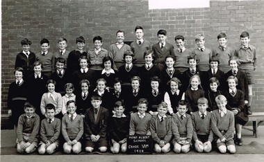
Photograph, Mont Albert Central School Grade 6M, 1958, 1958
Mont Albert State School was officially opened on 23rd April 1917. The school became Mont Albert Central School in 1918, taking in Forms 1 and 2. The school remained a Central School until 1964, when the secondary years formed the basis of a new High School, the Box Hill North High School, later to be named Koonung Secondary College. This is part of a large collection of material related to the Deakin, Mair and Young families, all with connections to Surrey Hills and Mont Albert. Laurie Young was the daughter of Beryl Mair (1916-1976) and Ernest Lance Young (1915-1999). The family lived at 5 York Street and later 11 York Street, Mont Albert. Laurie was born on 18 August 1947. Black and white class photo taken outside the school building. The class of 22 girls and 22 boys. Not all children are wearing school uniform."Laurie Young" in black ink in top LH corner. "Pupils of GRADE 6 MOLISER. / Of Mont AlbERT CENtERl / School" (?) in black ink.mont albert central school, laurie young, laurie newton, education -
 Surrey Hills Historical Society Collection
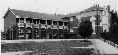
Photograph, Laurie Newton (nee Young), Mont Albert Central School, c1956, 1956
Mont Albert State School was officially opened on 23rd April 1917. The school became Mont Albert Central School in 1918, taking in Forms 1 and 2. The school remained a Central School until 1964, when the secondary years formed the basis of a new High School, the Box Hill North High School, later to be named Koonung Secondary College. This is part of a large collection of material related to the Deakin, Mair and Young families, all with connections to Surrey Hills and Mont Albert. Laurie Young was the daughter of Beryl Mair (1916-1976) and Ernest Lance Young (1915-1999). The family lived at 5 York Street and later 11 York Street, Mont Albert. Laurie was born on 18 August 1947. Black and white photo taken of the school building from the path from Barloa Street. There is one large bush to the left of the path obscuring the side of the main building. There is a wooden fire escape at the far end of the building. The grass in the foreground is patchy."School" underlined in blue ink, centre top. "MOnT ALBeRT CENTAL / School" centre in blue biro; thought to be the donor's hand. "GRADE" in blue ink "IV D" in blue ink. "APPROX: 1958" in blue biro; thought to be the donor's hand. These have been written by at least 2 hands and at different times.mont albert central school, laurie young, laurie newton, education -
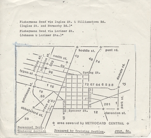 Melbourne Tram Museum
Drawing, Melbourne & Metropolitan Tramways Board (MMTB), "Area covered by MetroCard Central", Jul. 1980
Sheet (half foolscap?) photocopied, with a map of Melbourne tramway and bus routes drawn on it to show the extent of the ticket known as MetroCard Central. Dated July 1980. Prepared by the Training Section of the MMTB? For more details see http://www.robx1.net/victkt/pre1981/html/1980.htm - accessed 7/11/2018.trams, tramways, melbourne, tickets, mmtb, metrocard -
 Ringwood and District Historical Society
Flyer, Subdivisional Land Auction Sale Brochure, Grand Central Estate, Ringwood, Vic. - 1925
Douglas Street shown in the estate plan did not eventuate, but was developed as a public reserve. Refer also to Reg. No. 5149 for 1924 auction sale of land also titled Grand View Estate situated further north in Ringwood.Double sided multi-folded page advertising public auction sale on Saturday, 31st October, 1925, of residential allotments highlighting local facilities, services and layout of the estate. Includes panoramic view of Ringwood and other local photographic images.Subdivision includes Great Ryrie Street, Heathmont Road, Douglas Street, Garden Street, and Bellevue Avenue. Agents - Knight & Harwood, 315 Collins Street, Melbourne, Phone 10615, 10616 Central, in conjunction with J.B. McAlpin, Opposite Railway Station, Ringwood. Phone Ringwood 7. -
 Melbourne Tram Museum
Document - Report, Melbourne & Metropolitan Tramways Board (MMTB), "Travel time contours for travel by tram and train from the central business area", Jul. 1966
Report - Foolscap 11 typed pages, 12 bound sheets of diagrams and tables with card covers, with red binding strips, titled ""Travel time contours for travel by tram and train from the central business area", dated July 1966. Looks at journey time for both trams and trains with two speeds - 10mph and 18mph.In top left hand corner "Lees" in penciltrams, tramways, mmtb, tramways, railways, speed of services, travel promotion -
 Surrey Hills Historical Society Collection
Photograph, Mont Albert Central School Grade 3R, 1955, 1955
Mont Albert State School was officially opened on 23rd April 1917. The school became Mont Albert Central School in 1918, taking in Forms 1 and 2. The school remained a Central School until 1964, when the secondary years formed the basis of a new High School, the Box Hill North High School, later to be named Koonung Secondary College. As Laurie was in the photo of Class 2B, this photo may include one of her siblings. This is part of a large collection of material related to the Deakin, Mair and Young families, all with connections to Surrey Hills and Mont Albert. Laurie Young was the daughter of Beryl Mair (1916-1976) and Ernest Lance Young (1915-1999). The family lived at 5 York Street and later 11 York Street, Mont Albert. Laurie was born on 18 August 1947. Black and white class photo taken outside the school building. The class of 20 girls and 29 boys. Not all children are wearing school uniform. The children are flanked by an older gentleman wearing glasses (left facing) and a younger woman (right facing).Photographer's identification stamp in black ink " L.E. Reynolds / PHOTOGRAPHER / 35 RUSSELL STREET, / SURREY HILLS, E10"mont albert central school, laurie young, laurie newton, education -
 Melbourne Tram Museum
Document - Report, Melbourne & Metropolitan Tramways Board (MMTB), "Passenger movements by public transport for the Central city Business area based on results of the 1964 Melbourne Metropolitan Transportation Study, Nov. 1965
Report - Foolscap landscape format, red tape binding - approx. 80 pages with notes, diagrams, charts, maps showing passenger traffic for parts of each route, including Railway Stations, passenger flows, titled "Passenger movements by public transport for the Central city Business area based on results of the 1964 Melbourne Metropolitan Transportation Study.In top right hand corner "Lees" in inktrams, tramways, mmtb, tramways, melbourne, surveys, passengers, railways, maps -
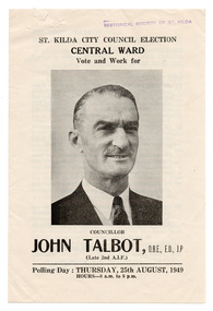
![Ephemera - Brochure, St Kilda City Council - Central Ward, Vote [1] Talbot, John, 1946](/media/collectors/510b3f7f023fd725b4cd52fc/items/665815e9b856f3991256874b/item-media/6661549f8056b80f34f7d429/item-fit-380x285.jpg) St Kilda Historical Society
St Kilda Historical SocietyEphemera - Brochure, St Kilda City Council - Central Ward, Vote [1] Talbot, John, 1946
Campaign material for the election of John Talbot as councillor for the Central Ward in the St Kilda City Council elections held on 22 August 1946. The brochure contains his personal and Army service details as well as polling day information. Talbot won the election and then served continuously until 1969, including three terms as mayor, in 1950-51, 1964-65 and 1965-66.Folded white paper (discoloured with age) printed in black on both sides, with a one page insert, printed in black on one sidejohn talbot, st kilda council, st kilda council elections -
 Federation University Historical Collection
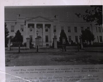
Photograph - Photograph - Black and White (Copy), Ballarat Hospital - Central Wing as it appeared in 1863, 1863
Copy of photographPrinted below photograph: "Central Wing facing Drummond Street, as it appeared in 1863. (Demolished in 1934 to allow the erection of the present Edward Wilson-Eildon House Building)" Daylesford, Beechworth, Maldon and Geelong Hospitals sought a united front for approach to the Colonial Treasurer on funds for charitable organizations, as ....... were at a critical levelballarat hospital, medicine, drummond street -
 St Kilda Historical Society
Ephemera - Brochure, St Kilda City Council Election, Central Ward, Vote and Work for Councillor John Talbot, 1949
Campaign material for the re-election of John Talbot as councillor for the Central Ward in the St Kilda City Council elections held on 25 August 1949. The brochure contains his personal details and municipal record, along with polling day details. Talbot was first elected in 1946 and served continuously until 1969, including three terms as mayor, in 1950-51, 1964-65 and 1965-66.Folded white paper (discoloured with age) printed in black on both sidesjohn talbot, st kilda council, st kilda council elections -
 Ballarat Heritage Services
Photograph, Clare Gervasoni, 103 Lyons Street South, Ballarat from outide 105 Lyons Street South, Ballarat Central, 28/05/2023
In 2023 103 Lyons Street South was sold and left uncared for after being sold in 2022. 103 Lyons Street South, Ballarat from outside 105 Lyons Street South, Ballarat Central. 103 Lyons street is a red brick house which was built c1980. When the previous house was demolished an mine shaft was discovered under the house and had to be capped. 105 Lyons Street South is a double brick Spanish Mission house with slat roof.103 lyons st south ballarat central, 105 lyons st south ballarat central, spanish mission, architecture, slate roof -
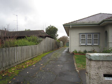 Ballarat Heritage Services
Photograph, Clare Gervasoni, Driveway between 103 Lyons Street South, and 105 Lyons Street South, Ballarat Central, 28/05/2023
In 2023 103 Lyons Street South was sold and left uncared for after being sold in 2022. 105 Lyons St South was in the middle of being painted.103 Lyons Street South, Ballarat from outside 105 Lyons Street South, Ballarat Central. 103 Lyons street is a red brick house which was built c1980. When the previous house was demolished an mine shaft was discovered under the house and had to be capped. 105 Lyons Street South is a double brick Spanish Mission house with slat roof.103 lyons st south ballarat central, 105 lyons st south ballarat central, spanish mission, architecture, slate roof -
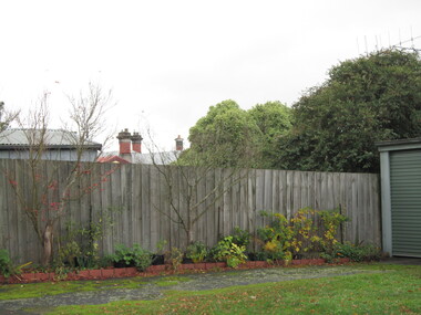 Ballarat Heritage Services
Photograph, Clare Gervasoni, Skyviews, rooflines and chimneys from 105 Lyons Street South, Looking Towards 103 Lyons Street South, Ballarat Central, 28/05/2023
In 2023 103 Lyons Street South was sold and left uncared for after being sold in 2022. 105 Lyons St South was in the middle of being painted.103 Lyons Street South, Ballarat from outside 105 Lyons Street South, Ballarat Central. 103 Lyons street is a red brick house which was built c1980. When the previous house was demolished an mine shaft was discovered under the house and had to be capped. 105 Lyons Street South is a double brick Spanish Mission house with slat roof.103 lyons st south ballarat central, 105 lyons st south ballarat central, spanish mission, architecture, slate roof -
 Kew Historical Society Inc
Plan - Subdivision Plan, Central Park Estate, Deepdene - Camberwell, 1923
The Kew Historical Society collection includes almost 100 subdivision plans pertaining to suburbs of the City of Melbourne. Most of these are of Kew, Kew East or Studley Park, although a smaller number are plans of Camberwell, Deepdene, Balwyn and Hawthorn. It is believed that the majority of the plans were gifted to the Society by persons connected with the real estate firm - J. R. Mathers and McMillan, 136 Cotham Road, Kew. The Plans in the collection are rarely in pristine form, being working plans on which the agent would write notes and record lots sold and the prices of these. The subdivision plans are historically significant examples of the growth of urban Melbourne from the beginning of the 20th Century up until the 1980s. A number of the plans are double-sided and often include a photograph on the reverse. A number of the latter are by noted photographers such as J.E. Barnes.An agent’s board on which parts of an advertisement for the Central Park Estate have been pasted. [The State Library of Victoria holds a complete plan]. Whereas the original plan included black and white photographs and effusive prose about the virtues of the Estate, the item in our collection includes only the actual blocks. The agent has annotated particular blocks to indicate that they have been sold.subdivision plans - deepdene - camberwell, central park estate