Showing 833 items
matching diamond creek road
-
 Eltham District Historical Society Inc
Photograph - Aerial Photograph, Landata, Eltham; Crown Allotment 15, Section 5, Parish of Nillumbik (Stokes Orchard Estate), Feb. 1979
... ring road link between Diamond Creek and Ringwood. The chosen... ring road link between Diamond Creek and Ringwood. The chosen ...Centred on present day Diosma Rd, Stokes Pl, Nyora Rd and Eucalyptus Rd Historic Aerial Imagery Source: Landata.vic.gov.au Aerial Photo Details: Project No :1716 Project : WESTERN PORT FORESHORES Run : 15 Frame : 91 Date : 02/1979 Film Type : B/W Camera : RC8 Flying Height : 5500 Scale : 10000 Film Number : 3286 GDA2020 : 37°42'47"S, 145°09'57"E MGA2020 : 338339, 5824447 (55) Melways : 22 C4 (ed. 42) A History of the Development of Crown Allotment 15, Section 5, Parish of Nillumbik – Stokes Orchard Crown Allotment 15, Section 5, Parish of Nillumbik (CA15) is a square allotment of 158 acres or approximately a quarter of a square mile. It lies just beyond the eastern end of Pitt Street, south of Nyora Road to the northern end of Eucalyptus Road and extends east from Eucalyptus Road to Reynolds Road. The topography of CA15 is generally steep, sloping up to a hill near the centre of the land, the ridgeline passing through the properties along the southern side of Diosma Road. Eucalyptus Road is a straight north-south road with its northern end at the north west corner of CA15. Until the end of the 1970s this road was an un-named Government Road and was largely not open to traffic. With residential development in the 1970s the road was constructed, and the council allocated the name obviously in recognition of the predominant species of the local bushland. CA15 was purchased from the Crown by George D’Arley Boursiquot, a prominent Melbourne printer, on 28th October 1852. On November 23, 1922, former Member for Gippsland and Melbourne Real Estate Agent, Hubert Patrick Keogh purchased the allotment then sold it March 13, 1925, to local farmer, Robert David Taylor, a former Shire of Eltham Councillor (1911-1920) and Shire President (1919). Taylor had extensive land holdings stretching west towards Bible Street and Main Road. The Taylor home was situated at the top of the hill in Bible Street at present day 82 Bible Street. At the time of Taylor’s purchase in 1925, CA15 was subdivided into 48 lots that could be described as small rural properties or large residential lots. A typical lot size was one hectare or 2.5 acres. The subdivision created two roads, Nyora Road, and Diosma Road, each following an irregular alignment between Eucalyptus and Reynolds Roads. However, the lots were not sold off separately nor were the roads constructed. The land effectively remained as one parcel for many further years. Robert David Taylor died November 30, 1934, and probate was granted to his son of the same name, Robert David Taylor of Bible Street, Salesman and William McLelland Vance Taylor of 73 Emmeline Street, Northcote, Clerk, with the transfer of the land into their names on July 8, 1935. Frank Stokes worked as a qualified accountant at Kennons leather factory in Burnley, while living at 1 Thomas Street, Mitcham. He suffered from migraines and wanted to return to working the land (he had previously worked on farms and orchards since coming to Australia from England in 1926, both in WA and Vic.). He first travelled to the district by train in July 1942 to find land with the intention to establish an orchard. By chance he met Arthur Bird of Bird Orchard (bounded by Pitt Street, Eucalyptus Road, and Wattle Grove) and they got talking over their common interest. Arthur put Frank up for the night and pointed out the land, 158 acres- part of the Taylor Estate- £900, Crown Allotment 15, Section 5, Parish of Nillumbik (CA15) somewhat diagonally opposite Bird Orchard. Stokes applied through the Riverina Agency to purchase the land who in turn applied for permission from Canberra to sell as there was a new government regulation introduced during the Second World War banning land sales except for immediate production. Stokes obtained a loan on his Mitcham house of £600 @ 5% and paid £450 deposit with quarterly payments of £15 spread over 5 years. Stokes was assisted and advised by Arthur Bird who farmed the neighbouring orchard. In early 1943 Stokes took possession and would catch the train out to Eltham on Fridays after work and began building a hut on the corner of Nyora Road and the Government Road (Eucalyptus Road) for shelter and to lock up tools. He established an orchard on the central western part of the land through the centre of which ran a natural waterway (part of the present-day linear park) and was able to pay a neighbour (Hawkins) to help with clearing and fencing 25 acres, and with a horse and single furrowed plough, planted approximately 2,500 fruit trees - cherries, peaches, plums, almonds, pears, apricots and lemons as well as a few apples and oranges; a massive task. Aerial photographs from the 1940s through to the 1990s clearly show the orchard with most of the larger CA15 site remaining as natural bushland. A huge problem was hares and rabbits eating all the new buds off the tiny trees. As well as laying poison he painted the trees with a mixture of cow manure and lime, often working by moonlight. Procurement of wire and wire netting was difficult because of the war but after much effort he obtained a permit from the Agricultural Department for supplies in March 1944. In February 1945 Stokes applied for a permit to build a “packing shed” as no house building was allowed. It was to be 33 feet x 21 feet and cost £312. It was constructed mostly from second-hand materials, which were hard to obtain, especially iron for roofing. Stokes finished work at Kennons on October 31, 1945, and in March 1946 he sold the family home at Mitcham for £1,230 plus £170 for furniture. On May 15, 1946, title to the CA15 property was issued to Frank Howard Alfred Stokes, Orchardist and Gladys Ethel Stokes, Married Woman, both of Pitt Street, Eltham. The family of five then moved into the very unfinished “packing shed” at Eltham, which was a struggle to weatherproof. Eventually rooms were divided off and lined with hessian bags and whitewashed. Their income was firewood (cut and sold), selling rockery stones and cut Sweet Bursaria. (It was discovered during the 1940s that Sweet Bursaria contained the sunscreen compound Aesculin. The RAAF utilised this compound from Sweet Bursaria during WW2 for pilots and gunners.) The orchard’s first fruit sale was a half-case of Le Vanq peaches in December 1947 for the price of 8 shillings. In 1956 plans for house were drawn and Glen Iris bricks purchased (1956 Olympic Rings variant). The building of the house commenced in 1957 - 12 feet of original packing shed was removed – and was completed in 1959. Water was connected from newly built pressure storage on the property at the end of 1959 and the electricity connection for the first time at 3pm on April 29, 1960. The house remains to present day (somewhat modified) at 1 Nyora Road, home to Nyora Studio Gallery. On occasions, spare remnants of the 1956 bricks have been known to be unearthed in gardens on the estate as they were utilised by Frank Stokes to fill in rabbit holes. On May 26, 1950, a parcel of land was compulsorily acquired by the Melbourne and Metropolitan Board of Works on the hilltop to establish an easement for a high-level service reservoir to augment Eltham’s water supply. The project also included pipe tracks for the necessary water mains. The reservoir has now been superseded by higher level water tanks east of Reynolds Road and its former site is now a public reserve. On November 27, 1964, the State Electricity Commission served notice to compulsorily acquire a further parcel through the eastern part of the land for a major electricity transmission line that augmented supply from the La Trobe Valley to Melbourne. The easement was registered February 11, 1966. The easement was widened July 18, 1969 for a second transmission line to be constructed. In 1971 Melbourne Metropolitan Planning Scheme amendments adopted Nyora Road as the boundary between a residential zone to the north and a rural zone to the south. This determined the future development of the land. In the mid-1970s the Shire of Eltham divided the orchard into numerous rate-able parcel lots, the 48 lots having been established in 1925 and the subsequent rates assessment proved unsustainable for Stokes. He commenced selling lots outside the boundary of the orchard, north of Diosma and South of Nyora. However shortly later the land between Nyora and Diosma Roads and west of the electricity easement was sold and subdivided into residential lots, a housing development by Macquarie Builders and marketed as the Stokes Orchard Estate. New streets were created, and most were named after trees, although one, Stokes Place, commemorates the former owners. The development was undertaken in two stages; Stage 1 (1975) encompassing Scarlet Ash Court, Ironbark Close and Peppermint Grove bounded by Nyora and Eucalyptus roads and Stage 2 (1978) encompassing Stokes Place, Orchard Way, The Crest and The Lookout bound by Nyora and Diosma roads. The developer, Macquarie Builders went bankrupt shortly after the release of Stage 2 leaving many purchasers to fend for themselves and arrange for their own independent builders. There were also difficulties with sewerage for the land immediately south of Diosma Road and so the conventional residential lots were abandoned in favour of larger lots. The development of Orchard Way, The Crest and The Lookout did not proceed as planned and the proposed lots were incorporated into five-acre parcels instead. These included a low-density group housing development by the Graves family and the award winning Choong House (1983) with Gordon Ford developed garden immediately next door situated on the ridge of the hill nestled amongst the original bush, Eucalypt trees and Sweet Bursaria. In 1994, Nillumbik Shire Council applied Significant Environment and Significant Landscape overlays upon the properties on the south side of Diosma Road to ensure protection of this natural bush garden environment. With the arrival of the sewer along Diosma Road in the 1990s, most of these five-acre parcels have since been subdivided multiple times. The Choong house presently sits on a 2.7-acre property, which in 2022 Nillumbik Council nominated for Cultural Significance Heritage protection and is considered potentially significant at State level. The Stokes family were also associated with the Eltham Christian Church. In the 1970s this church had met in temporary premises in Eltham. Lots of the original 1925 subdivision remained south of Nyora Road and a number of these lots were utilized for the Eltham Christian School, which was established by the Eltham Christian Church in 1981. The school operated on this site until 2000. The premises are now used by The Vine Baptist Church. By the mid-1980s the whole of CA15 had been developed for residential and school purposes, except for the sections north of Diosma Road and between the transmission lines and Reynolds Road. Sewerage issues had been resolved for the section north of Diosma Road and in 1987 it was in the process of being subdivided into residential lots. The development coincided with the discovery of colonies of the rare and endangered Eltham Copper Butterfly on the site. This resulted in a community and political campaign to save the butterfly habitat. With the co-operation of the land developer the subdivision was altered to create two bushland reserves in the critical butterfly habitat areas. In the late 1980s the State Government was investigating options for establishing a metropolitan ring road link between Diamond Creek and Ringwood. The chosen route was adjacent to Reynolds Road and so this created a freeze on development of CA15 between Reynolds Road and the electricity easement. The ring road proposal was eventually abandoned, and this part of the land was subdivided into low density residential lots. Diosma Road has been discontinued at the electricity easement and the eastern part incorporated into View Mount Court with access from Reynolds Road. The whole of CA15 has now been developed for residential or associated purposes, ranging from conventional density to quite low density south of Nyora Road. Some remnants of the orchard remain, a few cherry trees on the Graves property and a lone apple tree in Stokes Place. The butterfly reserves comprise significant areas of remnant bushland. Linear reserves through the estate link with central Eltham via the Woodridge linear reserve and with Research along the electricity easement. CA15 as it exists today has a complicated history of rural use, Government acquisition, urban development, and community action. References: • “Stokes Orchard, an incomplete history”; Russell Yeoman with Doug Orford • Correspondence, Beryl Bradbury (nee Stokes) • Aerial Photographs, 1931-1991, Landata (landata.vic.gov.au) • Certificate of Title, Vol. 4930 Fol. 985900 • Plan Number LP 10859 aerial photo, diosma road, eltham copper butterfly, eucalyptus road, ironbark close, nyora road, peppermint grove, peter & elizabeth pidgeon collection, power transmission lines, reynolds road, scarlet ash court, stokes orchard estate, stokes place, woodridge estate, frank stokes -
 Eltham District Historical Society Inc
Photograph - Aerial Photograph, Landata, Eltham; Crown Allotment 15, Section 5, Parish of Nillumbik (Stokes Orchard Estate), Jan. 1984
... ring road link between Diamond Creek and Ringwood. The chosen... ring road link between Diamond Creek and Ringwood. The chosen ...Centred on present day Diosma Rd, Stokes Pl, Nyora Rd and Eucalyptus Rd Historic Aerial Imagery Source: Landata.vic.gov.au Aerial Photo Details: Project No :1716 Project : WESTERN PORT FORESHORES Run : 15 Frame : 70 Date : 01/1984 Film Type : B/W Camera : RC8 Flying Height : 5300 Scale : 10000 Film Number : 3833 GDA2020 : 37°42'38"S, 145°10'09"E MGA2020 : 338612, 5824719 (55) Melways : 22 D4 (ed. 42) A History of the Development of Crown Allotment 15, Section 5, Parish of Nillumbik – Stokes Orchard Crown Allotment 15, Section 5, Parish of Nillumbik (CA15) is a square allotment of 158 acres or approximately a quarter of a square mile. It lies just beyond the eastern end of Pitt Street, south of Nyora Road to the northern end of Eucalyptus Road and extends east from Eucalyptus Road to Reynolds Road. The topography of CA15 is generally steep, sloping up to a hill near the centre of the land, the ridgeline passing through the properties along the southern side of Diosma Road. Eucalyptus Road is a straight north-south road with its northern end at the north west corner of CA15. Until the end of the 1970s this road was an un-named Government Road and was largely not open to traffic. With residential development in the 1970s the road was constructed, and the council allocated the name obviously in recognition of the predominant species of the local bushland. CA15 was purchased from the Crown by George D’Arley Boursiquot, a prominent Melbourne printer, on 28th October 1852. On November 23, 1922, former Member for Gippsland and Melbourne Real Estate Agent, Hubert Patrick Keogh purchased the allotment then sold it March 13, 1925, to local farmer, Robert David Taylor, a former Shire of Eltham Councillor (1911-1920) and Shire President (1919). Taylor had extensive land holdings stretching west towards Bible Street and Main Road. The Taylor home was situated at the top of the hill in Bible Street at present day 82 Bible Street. At the time of Taylor’s purchase in 1925, CA15 was subdivided into 48 lots that could be described as small rural properties or large residential lots. A typical lot size was one hectare or 2.5 acres. The subdivision created two roads, Nyora Road, and Diosma Road, each following an irregular alignment between Eucalyptus and Reynolds Roads. However, the lots were not sold off separately nor were the roads constructed. The land effectively remained as one parcel for many further years. Robert David Taylor died November 30, 1934, and probate was granted to his son of the same name, Robert David Taylor of Bible Street, Salesman and William McLelland Vance Taylor of 73 Emmeline Street, Northcote, Clerk, with the transfer of the land into their names on July 8, 1935. Frank Stokes worked as a qualified accountant at Kennons leather factory in Burnley, while living at 1 Thomas Street, Mitcham. He suffered from migraines and wanted to return to working the land (he had previously worked on farms and orchards since coming to Australia from England in 1926, both in WA and Vic.). He first travelled to the district by train in July 1942 to find land with the intention to establish an orchard. By chance he met Arthur Bird of Bird Orchard (bounded by Pitt Street, Eucalyptus Road, and Wattle Grove) and they got talking over their common interest. Arthur put Frank up for the night and pointed out the land, 158 acres- part of the Taylor Estate- £900, Crown Allotment 15, Section 5, Parish of Nillumbik (CA15) somewhat diagonally opposite Bird Orchard. Stokes applied through the Riverina Agency to purchase the land who in turn applied for permission from Canberra to sell as there was a new government regulation introduced during the Second World War banning land sales except for immediate production. Stokes obtained a loan on his Mitcham house of £600 @ 5% and paid £450 deposit with quarterly payments of £15 spread over 5 years. Stokes was assisted and advised by Arthur Bird who farmed the neighbouring orchard. In early 1943 Stokes took possession and would catch the train out to Eltham on Fridays after work and began building a hut on the corner of Nyora Road and the Government Road (Eucalyptus Road) for shelter and to lock up tools. He established an orchard on the central western part of the land through the centre of which ran a natural waterway (part of the present-day linear park) and was able to pay a neighbour (Hawkins) to help with clearing and fencing 25 acres, and with a horse and single furrowed plough, planted approximately 2,500 fruit trees - cherries, peaches, plums, almonds, pears, apricots and lemons as well as a few apples and oranges; a massive task. Aerial photographs from the 1940s through to the 1990s clearly show the orchard with most of the larger CA15 site remaining as natural bushland. A huge problem was hares and rabbits eating all the new buds off the tiny trees. As well as laying poison he painted the trees with a mixture of cow manure and lime, often working by moonlight. Procurement of wire and wire netting was difficult because of the war but after much effort he obtained a permit from the Agricultural Department for supplies in March 1944. In February 1945 Stokes applied for a permit to build a “packing shed” as no house building was allowed. It was to be 33 feet x 21 feet and cost £312. It was constructed mostly from second-hand materials, which were hard to obtain, especially iron for roofing. Stokes finished work at Kennons on October 31, 1945, and in March 1946 he sold the family home at Mitcham for £1,230 plus £170 for furniture. On May 15, 1946, title to the CA15 property was issued to Frank Howard Alfred Stokes, Orchardist and Gladys Ethel Stokes, Married Woman, both of Pitt Street, Eltham. The family of five then moved into the very unfinished “packing shed” at Eltham, which was a struggle to weatherproof. Eventually rooms were divided off and lined with hessian bags and whitewashed. Their income was firewood (cut and sold), selling rockery stones and cut Sweet Bursaria. (It was discovered during the 1940s that Sweet Bursaria contained the sunscreen compound Aesculin. The RAAF utilised this compound from Sweet Bursaria during WW2 for pilots and gunners.) The orchard’s first fruit sale was a half-case of Le Vanq peaches in December 1947 for the price of 8 shillings. In 1956 plans for house were drawn and Glen Iris bricks purchased (1956 Olympic Rings variant). The building of the house commenced in 1957 - 12 feet of original packing shed was removed – and was completed in 1959. Water was connected from newly built pressure storage on the property at the end of 1959 and the electricity connection for the first time at 3pm on April 29, 1960. The house remains to present day (somewhat modified) at 1 Nyora Road, home to Nyora Studio Gallery. On occasions, spare remnants of the 1956 bricks have been known to be unearthed in gardens on the estate as they were utilised by Frank Stokes to fill in rabbit holes. On May 26, 1950, a parcel of land was compulsorily acquired by the Melbourne and Metropolitan Board of Works on the hilltop to establish an easement for a high-level service reservoir to augment Eltham’s water supply. The project also included pipe tracks for the necessary water mains. The reservoir has now been superseded by higher level water tanks east of Reynolds Road and its former site is now a public reserve. On November 27, 1964, the State Electricity Commission served notice to compulsorily acquire a further parcel through the eastern part of the land for a major electricity transmission line that augmented supply from the La Trobe Valley to Melbourne. The easement was registered February 11, 1966. The easement was widened July 18, 1969 for a second transmission line to be constructed. In 1971 Melbourne Metropolitan Planning Scheme amendments adopted Nyora Road as the boundary between a residential zone to the north and a rural zone to the south. This determined the future development of the land. In the mid-1970s the Shire of Eltham divided the orchard into numerous rate-able parcel lots, the 48 lots having been established in 1925 and the subsequent rates assessment proved unsustainable for Stokes. He commenced selling lots outside the boundary of the orchard, north of Diosma and South of Nyora. However shortly later the land between Nyora and Diosma Roads and west of the electricity easement was sold and subdivided into residential lots, a housing development by Macquarie Builders and marketed as the Stokes Orchard Estate. New streets were created, and most were named after trees, although one, Stokes Place, commemorates the former owners. The development was undertaken in two stages; Stage 1 (1975) encompassing Scarlet Ash Court, Ironbark Close and Peppermint Grove bounded by Nyora and Eucalyptus roads and Stage 2 (1978) encompassing Stokes Place, Orchard Way, The Crest and The Lookout bound by Nyora and Diosma roads. The developer, Macquarie Builders went bankrupt shortly after the release of Stage 2 leaving many purchasers to fend for themselves and arrange for their own independent builders. There were also difficulties with sewerage for the land immediately south of Diosma Road and so the conventional residential lots were abandoned in favour of larger lots. The development of Orchard Way, The Crest and The Lookout did not proceed as planned and the proposed lots were incorporated into five-acre parcels instead. These included a low-density group housing development by the Graves family and the award winning Choong House (1983) with Gordon Ford developed garden immediately next door situated on the ridge of the hill nestled amongst the original bush, Eucalypt trees and Sweet Bursaria. In 1994, Nillumbik Shire Council applied Significant Environment and Significant Landscape overlays upon the properties on the south side of Diosma Road to ensure protection of this natural bush garden environment. With the arrival of the sewer along Diosma Road in the 1990s, most of these five-acre parcels have since been subdivided multiple times. The Choong house presently sits on a 2.7-acre property, which in 2022 Nillumbik Council nominated for Cultural Significance Heritage protection and is considered potentially significant at State level. The Stokes family were also associated with the Eltham Christian Church. In the 1970s this church had met in temporary premises in Eltham. Lots of the original 1925 subdivision remained south of Nyora Road and a number of these lots were utilized for the Eltham Christian School, which was established by the Eltham Christian Church in 1981. The school operated on this site until 2000. The premises are now used by The Vine Baptist Church. By the mid-1980s the whole of CA15 had been developed for residential and school purposes, except for the sections north of Diosma Road and between the transmission lines and Reynolds Road. Sewerage issues had been resolved for the section north of Diosma Road and in 1987 it was in the process of being subdivided into residential lots. The development coincided with the discovery of colonies of the rare and endangered Eltham Copper Butterfly on the site. This resulted in a community and political campaign to save the butterfly habitat. With the co-operation of the land developer the subdivision was altered to create two bushland reserves in the critical butterfly habitat areas. In the late 1980s the State Government was investigating options for establishing a metropolitan ring road link between Diamond Creek and Ringwood. The chosen route was adjacent to Reynolds Road and so this created a freeze on development of CA15 between Reynolds Road and the electricity easement. The ring road proposal was eventually abandoned, and this part of the land was subdivided into low density residential lots. Diosma Road has been discontinued at the electricity easement and the eastern part incorporated into View Mount Court with access from Reynolds Road. The whole of CA15 has now been developed for residential or associated purposes, ranging from conventional density to quite low density south of Nyora Road. Some remnants of the orchard remain, a few cherry trees on the Graves property and a lone apple tree in Stokes Place. The butterfly reserves comprise significant areas of remnant bushland. Linear reserves through the estate link with central Eltham via the Woodridge linear reserve and with Research along the electricity easement. CA15 as it exists today has a complicated history of rural use, Government acquisition, urban development, and community action. References: • “Stokes Orchard, an incomplete history”; Russell Yeoman with Doug Orford • Correspondence, Beryl Bradbury (nee Stokes) • Aerial Photographs, 1931-1991, Landata (landata.vic.gov.au) • Certificate of Title, Vol. 4930 Fol. 985900 • Plan Number LP 10859 aerial photo, diosma road, eltham copper butterfly, eucalyptus road, ironbark close, nyora road, peppermint grove, peter & elizabeth pidgeon collection, power transmission lines, reynolds road, scarlet ash court, stokes orchard estate, stokes place, woodridge estate, frank stokes -
 Eltham District Historical Society Inc
Photograph - Aerial Photograph, Landata, Eltham; Crown Allotment 15, Section 5, Parish of Nillumbik (Stokes Orchard Estate), Mar. 1987
... ring road link between Diamond Creek and Ringwood. The chosen... ring road link between Diamond Creek and Ringwood. The chosen ...Centred on present day Diosma Rd, Stokes Pl, Nyora Rd and Eucalyptus Rd Historic Aerial Imagery Source: Landata.vic.gov.au Aerial Photo Details: Project No :1716 Project : WESTERN PORT FORESHORES Run : 15 Frame : 108 Date : 03/1987 Film Type : B/W Camera : RC10 Flying Height : 5600 Scale : 10000 Film Number : 4102 GDA2020 : 37°43'00"S, 145°10'13"E MGA2020 : 338725, 5824036 (55) Melways : 22 D5 (ed. 42)719 (55) Melways : 22 D4 (ed. 42) A History of the Development of Crown Allotment 15, Section 5, Parish of Nillumbik – Stokes Orchard Crown Allotment 15, Section 5, Parish of Nillumbik (CA15) is a square allotment of 158 acres or approximately a quarter of a square mile. It lies just beyond the eastern end of Pitt Street, south of Nyora Road to the northern end of Eucalyptus Road and extends east from Eucalyptus Road to Reynolds Road. The topography of CA15 is generally steep, sloping up to a hill near the centre of the land, the ridgeline passing through the properties along the southern side of Diosma Road. Eucalyptus Road is a straight north-south road with its northern end at the north west corner of CA15. Until the end of the 1970s this road was an un-named Government Road and was largely not open to traffic. With residential development in the 1970s the road was constructed, and the council allocated the name obviously in recognition of the predominant species of the local bushland. CA15 was purchased from the Crown by George D’Arley Boursiquot, a prominent Melbourne printer, on 28th October 1852. On November 23, 1922, former Member for Gippsland and Melbourne Real Estate Agent, Hubert Patrick Keogh purchased the allotment then sold it March 13, 1925, to local farmer, Robert David Taylor, a former Shire of Eltham Councillor (1911-1920) and Shire President (1919). Taylor had extensive land holdings stretching west towards Bible Street and Main Road. The Taylor home was situated at the top of the hill in Bible Street at present day 82 Bible Street. At the time of Taylor’s purchase in 1925, CA15 was subdivided into 48 lots that could be described as small rural properties or large residential lots. A typical lot size was one hectare or 2.5 acres. The subdivision created two roads, Nyora Road, and Diosma Road, each following an irregular alignment between Eucalyptus and Reynolds Roads. However, the lots were not sold off separately nor were the roads constructed. The land effectively remained as one parcel for many further years. Robert David Taylor died November 30, 1934, and probate was granted to his son of the same name, Robert David Taylor of Bible Street, Salesman and William McLelland Vance Taylor of 73 Emmeline Street, Northcote, Clerk, with the transfer of the land into their names on July 8, 1935. Frank Stokes worked as a qualified accountant at Kennons leather factory in Burnley, while living at 1 Thomas Street, Mitcham. He suffered from migraines and wanted to return to working the land (he had previously worked on farms and orchards since coming to Australia from England in 1926, both in WA and Vic.). He first travelled to the district by train in July 1942 to find land with the intention to establish an orchard. By chance he met Arthur Bird of Bird Orchard (bounded by Pitt Street, Eucalyptus Road, and Wattle Grove) and they got talking over their common interest. Arthur put Frank up for the night and pointed out the land, 158 acres- part of the Taylor Estate- £900, Crown Allotment 15, Section 5, Parish of Nillumbik (CA15) somewhat diagonally opposite Bird Orchard. Stokes applied through the Riverina Agency to purchase the land who in turn applied for permission from Canberra to sell as there was a new government regulation introduced during the Second World War banning land sales except for immediate production. Stokes obtained a loan on his Mitcham house of £600 @ 5% and paid £450 deposit with quarterly payments of £15 spread over 5 years. Stokes was assisted and advised by Arthur Bird who farmed the neighbouring orchard. In early 1943 Stokes took possession and would catch the train out to Eltham on Fridays after work and began building a hut on the corner of Nyora Road and the Government Road (Eucalyptus Road) for shelter and to lock up tools. He established an orchard on the central western part of the land through the centre of which ran a natural waterway (part of the present-day linear park) and was able to pay a neighbour (Hawkins) to help with clearing and fencing 25 acres, and with a horse and single furrowed plough, planted approximately 2,500 fruit trees - cherries, peaches, plums, almonds, pears, apricots and lemons as well as a few apples and oranges; a massive task. Aerial photographs from the 1940s through to the 1990s clearly show the orchard with most of the larger CA15 site remaining as natural bushland. A huge problem was hares and rabbits eating all the new buds off the tiny trees. As well as laying poison he painted the trees with a mixture of cow manure and lime, often working by moonlight. Procurement of wire and wire netting was difficult because of the war but after much effort he obtained a permit from the Agricultural Department for supplies in March 1944. In February 1945 Stokes applied for a permit to build a “packing shed” as no house building was allowed. It was to be 33 feet x 21 feet and cost £312. It was constructed mostly from second-hand materials, which were hard to obtain, especially iron for roofing. Stokes finished work at Kennons on October 31, 1945, and in March 1946 he sold the family home at Mitcham for £1,230 plus £170 for furniture. On May 15, 1946, title to the CA15 property was issued to Frank Howard Alfred Stokes, Orchardist and Gladys Ethel Stokes, Married Woman, both of Pitt Street, Eltham. The family of five then moved into the very unfinished “packing shed” at Eltham, which was a struggle to weatherproof. Eventually rooms were divided off and lined with hessian bags and whitewashed. Their income was firewood (cut and sold), selling rockery stones and cut Sweet Bursaria. (It was discovered during the 1940s that Sweet Bursaria contained the sunscreen compound Aesculin. The RAAF utilised this compound from Sweet Bursaria during WW2 for pilots and gunners.) The orchard’s first fruit sale was a half-case of Le Vanq peaches in December 1947 for the price of 8 shillings. In 1956 plans for house were drawn and Glen Iris bricks purchased (1956 Olympic Rings variant). The building of the house commenced in 1957 - 12 feet of original packing shed was removed – and was completed in 1959. Water was connected from newly built pressure storage on the property at the end of 1959 and the electricity connection for the first time at 3pm on April 29, 1960. The house remains to present day (somewhat modified) at 1 Nyora Road, home to Nyora Studio Gallery. On occasions, spare remnants of the 1956 bricks have been known to be unearthed in gardens on the estate as they were utilised by Frank Stokes to fill in rabbit holes. On May 26, 1950, a parcel of land was compulsorily acquired by the Melbourne and Metropolitan Board of Works on the hilltop to establish an easement for a high-level service reservoir to augment Eltham’s water supply. The project also included pipe tracks for the necessary water mains. The reservoir has now been superseded by higher level water tanks east of Reynolds Road and its former site is now a public reserve. On November 27, 1964, the State Electricity Commission served notice to compulsorily acquire a further parcel through the eastern part of the land for a major electricity transmission line that augmented supply from the La Trobe Valley to Melbourne. The easement was registered February 11, 1966. The easement was widened July 18, 1969 for a second transmission line to be constructed. In 1971 Melbourne Metropolitan Planning Scheme amendments adopted Nyora Road as the boundary between a residential zone to the north and a rural zone to the south. This determined the future development of the land. In the mid-1970s the Shire of Eltham divided the orchard into numerous rate-able parcel lots, the 48 lots having been established in 1925 and the subsequent rates assessment proved unsustainable for Stokes. He commenced selling lots outside the boundary of the orchard, north of Diosma and South of Nyora. However shortly later the land between Nyora and Diosma Roads and west of the electricity easement was sold and subdivided into residential lots, a housing development by Macquarie Builders and marketed as the Stokes Orchard Estate. New streets were created, and most were named after trees, although one, Stokes Place, commemorates the former owners. The development was undertaken in two stages; Stage 1 (1975) encompassing Scarlet Ash Court, Ironbark Close and Peppermint Grove bounded by Nyora and Eucalyptus roads and Stage 2 (1978) encompassing Stokes Place, Orchard Way, The Crest and The Lookout bound by Nyora and Diosma roads. The developer, Macquarie Builders went bankrupt shortly after the release of Stage 2 leaving many purchasers to fend for themselves and arrange for their own independent builders. There were also difficulties with sewerage for the land immediately south of Diosma Road and so the conventional residential lots were abandoned in favour of larger lots. The development of Orchard Way, The Crest and The Lookout did not proceed as planned and the proposed lots were incorporated into five-acre parcels instead. These included a low-density group housing development by the Graves family and the award winning Choong House (1983) with Gordon Ford developed garden immediately next door situated on the ridge of the hill nestled amongst the original bush, Eucalypt trees and Sweet Bursaria. In 1994, Nillumbik Shire Council applied Significant Environment and Significant Landscape overlays upon the properties on the south side of Diosma Road to ensure protection of this natural bush garden environment. With the arrival of the sewer along Diosma Road in the 1990s, most of these five-acre parcels have since been subdivided multiple times. The Choong house presently sits on a 2.7-acre property, which in 2022 Nillumbik Council nominated for Cultural Significance Heritage protection and is considered potentially significant at State level. The Stokes family were also associated with the Eltham Christian Church. In the 1970s this church had met in temporary premises in Eltham. Lots of the original 1925 subdivision remained south of Nyora Road and a number of these lots were utilized for the Eltham Christian School, which was established by the Eltham Christian Church in 1981. The school operated on this site until 2000. The premises are now used by The Vine Baptist Church. By the mid-1980s the whole of CA15 had been developed for residential and school purposes, except for the sections north of Diosma Road and between the transmission lines and Reynolds Road. Sewerage issues had been resolved for the section north of Diosma Road and in 1987 it was in the process of being subdivided into residential lots. The development coincided with the discovery of colonies of the rare and endangered Eltham Copper Butterfly on the site. This resulted in a community and political campaign to save the butterfly habitat. With the co-operation of the land developer the subdivision was altered to create two bushland reserves in the critical butterfly habitat areas. In the late 1980s the State Government was investigating options for establishing a metropolitan ring road link between Diamond Creek and Ringwood. The chosen route was adjacent to Reynolds Road and so this created a freeze on development of CA15 between Reynolds Road and the electricity easement. The ring road proposal was eventually abandoned, and this part of the land was subdivided into low density residential lots. Diosma Road has been discontinued at the electricity easement and the eastern part incorporated into View Mount Court with access from Reynolds Road. The whole of CA15 has now been developed for residential or associated purposes, ranging from conventional density to quite low density south of Nyora Road. Some remnants of the orchard remain, a few cherry trees on the Graves property and a lone apple tree in Stokes Place. The butterfly reserves comprise significant areas of remnant bushland. Linear reserves through the estate link with central Eltham via the Woodridge linear reserve and with Research along the electricity easement. CA15 as it exists today has a complicated history of rural use, Government acquisition, urban development, and community action. References: • “Stokes Orchard, an incomplete history”; Russell Yeoman with Doug Orford • Correspondence, Beryl Bradbury (nee Stokes) • Aerial Photographs, 1931-1991, Landata (landata.vic.gov.au) • Certificate of Title, Vol. 4930 Fol. 985900 • Plan Number LP 10859 aerial photo, diosma road, eltham copper butterfly, eucalyptus road, ironbark close, nyora road, peppermint grove, peter & elizabeth pidgeon collection, power transmission lines, reynolds road, scarlet ash court, stokes orchard estate, stokes place, woodridge estate, frank stokes -
 Eltham District Historical Society Inc
Photograph - Aerial Photograph, Landata, Eltham; Crown Allotment 15, Section 5, Parish of Nillumbik (Stokes Orchard Estate), Sep. 1991
... ring road link between Diamond Creek and Ringwood. The chosen... ring road link between Diamond Creek and Ringwood. The chosen ...Centred on present day Diosma Rd, Stokes Pl, Nyora Rd and Eucalyptus Rd Historic Aerial Imagery Source: Landata.vic.gov.au Aerial Photo Details: Project No :2072 Project : MELBOURNE PROJECT Run : 13 Frame : 119 Date : 09/1991 Film Type : COL Camera : RC10 Flying Height : 8300 Scale : 15000 Film Number : 4419 GDA2020 : 37°43'07"S, 145°09'35"E MGA2020 : 337812, 5823811 (55) Melways : 22 B6 (ed. 42) A History of the Development of Crown Allotment 15, Section 5, Parish of Nillumbik – Stokes Orchard Crown Allotment 15, Section 5, Parish of Nillumbik (CA15) is a square allotment of 158 acres or approximately a quarter of a square mile. It lies just beyond the eastern end of Pitt Street, south of Nyora Road to the northern end of Eucalyptus Road and extends east from Eucalyptus Road to Reynolds Road. The topography of CA15 is generally steep, sloping up to a hill near the centre of the land, the ridgeline passing through the properties along the southern side of Diosma Road. Eucalyptus Road is a straight north-south road with its northern end at the north west corner of CA15. Until the end of the 1970s this road was an un-named Government Road and was largely not open to traffic. With residential development in the 1970s the road was constructed, and the council allocated the name obviously in recognition of the predominant species of the local bushland. CA15 was purchased from the Crown by George D’Arley Boursiquot, a prominent Melbourne printer, on 28th October 1852. On November 23, 1922, former Member for Gippsland and Melbourne Real Estate Agent, Hubert Patrick Keogh purchased the allotment then sold it March 13, 1925, to local farmer, Robert David Taylor, a former Shire of Eltham Councillor (1911-1920) and Shire President (1919). Taylor had extensive land holdings stretching west towards Bible Street and Main Road. The Taylor home was situated at the top of the hill in Bible Street at present day 82 Bible Street. At the time of Taylor’s purchase in 1925, CA15 was subdivided into 48 lots that could be described as small rural properties or large residential lots. A typical lot size was one hectare or 2.5 acres. The subdivision created two roads, Nyora Road, and Diosma Road, each following an irregular alignment between Eucalyptus and Reynolds Roads. However, the lots were not sold off separately nor were the roads constructed. The land effectively remained as one parcel for many further years. Robert David Taylor died November 30, 1934, and probate was granted to his son of the same name, Robert David Taylor of Bible Street, Salesman and William McLelland Vance Taylor of 73 Emmeline Street, Northcote, Clerk, with the transfer of the land into their names on July 8, 1935. Frank Stokes worked as a qualified accountant at Kennons leather factory in Burnley, while living at 1 Thomas Street, Mitcham. He suffered from migraines and wanted to return to working the land (he had previously worked on farms and orchards since coming to Australia from England in 1926, both in WA and Vic.). He first travelled to the district by train in July 1942 to find land with the intention to establish an orchard. By chance he met Arthur Bird of Bird Orchard (bounded by Pitt Street, Eucalyptus Road, and Wattle Grove) and they got talking over their common interest. Arthur put Frank up for the night and pointed out the land, 158 acres- part of the Taylor Estate- £900, Crown Allotment 15, Section 5, Parish of Nillumbik (CA15) somewhat diagonally opposite Bird Orchard. Stokes applied through the Riverina Agency to purchase the land who in turn applied for permission from Canberra to sell as there was a new government regulation introduced during the Second World War banning land sales except for immediate production. Stokes obtained a loan on his Mitcham house of £600 @ 5% and paid £450 deposit with quarterly payments of £15 spread over 5 years. Stokes was assisted and advised by Arthur Bird who farmed the neighbouring orchard. In early 1943 Stokes took possession and would catch the train out to Eltham on Fridays after work and began building a hut on the corner of Nyora Road and the Government Road (Eucalyptus Road) for shelter and to lock up tools. He established an orchard on the central western part of the land through the centre of which ran a natural waterway (part of the present-day linear park) and was able to pay a neighbour (Hawkins) to help with clearing and fencing 25 acres, and with a horse and single furrowed plough, planted approximately 2,500 fruit trees - cherries, peaches, plums, almonds, pears, apricots and lemons as well as a few apples and oranges; a massive task. Aerial photographs from the 1940s through to the 1990s clearly show the orchard with most of the larger CA15 site remaining as natural bushland. A huge problem was hares and rabbits eating all the new buds off the tiny trees. As well as laying poison he painted the trees with a mixture of cow manure and lime, often working by moonlight. Procurement of wire and wire netting was difficult because of the war but after much effort he obtained a permit from the Agricultural Department for supplies in March 1944. In February 1945 Stokes applied for a permit to build a “packing shed” as no house building was allowed. It was to be 33 feet x 21 feet and cost £312. It was constructed mostly from second-hand materials, which were hard to obtain, especially iron for roofing. Stokes finished work at Kennons on October 31, 1945, and in March 1946 he sold the family home at Mitcham for £1,230 plus £170 for furniture. On May 15, 1946, title to the CA15 property was issued to Frank Howard Alfred Stokes, Orchardist and Gladys Ethel Stokes, Married Woman, both of Pitt Street, Eltham. The family of five then moved into the very unfinished “packing shed” at Eltham, which was a struggle to weatherproof. Eventually rooms were divided off and lined with hessian bags and whitewashed. Their income was firewood (cut and sold), selling rockery stones and cut Sweet Bursaria. (It was discovered during the 1940s that Sweet Bursaria contained the sunscreen compound Aesculin. The RAAF utilised this compound from Sweet Bursaria during WW2 for pilots and gunners.) The orchard’s first fruit sale was a half-case of Le Vanq peaches in December 1947 for the price of 8 shillings. In 1956 plans for house were drawn and Glen Iris bricks purchased (1956 Olympic Rings variant). The building of the house commenced in 1957 - 12 feet of original packing shed was removed – and was completed in 1959. Water was connected from newly built pressure storage on the property at the end of 1959 and the electricity connection for the first time at 3pm on April 29, 1960. The house remains to present day (somewhat modified) at 1 Nyora Road, home to Nyora Studio Gallery. On occasions, spare remnants of the 1956 bricks have been known to be unearthed in gardens on the estate as they were utilised by Frank Stokes to fill in rabbit holes. On May 26, 1950, a parcel of land was compulsorily acquired by the Melbourne and Metropolitan Board of Works on the hilltop to establish an easement for a high-level service reservoir to augment Eltham’s water supply. The project also included pipe tracks for the necessary water mains. The reservoir has now been superseded by higher level water tanks east of Reynolds Road and its former site is now a public reserve. On November 27, 1964, the State Electricity Commission served notice to compulsorily acquire a further parcel through the eastern part of the land for a major electricity transmission line that augmented supply from the La Trobe Valley to Melbourne. The easement was registered February 11, 1966. The easement was widened July 18, 1969 for a second transmission line to be constructed. In 1971 Melbourne Metropolitan Planning Scheme amendments adopted Nyora Road as the boundary between a residential zone to the north and a rural zone to the south. This determined the future development of the land. In the mid-1970s the Shire of Eltham divided the orchard into numerous rate-able parcel lots, the 48 lots having been established in 1925 and the subsequent rates assessment proved unsustainable for Stokes. He commenced selling lots outside the boundary of the orchard, north of Diosma and South of Nyora. However shortly later the land between Nyora and Diosma Roads and west of the electricity easement was sold and subdivided into residential lots, a housing development by Macquarie Builders and marketed as the Stokes Orchard Estate. New streets were created, and most were named after trees, although one, Stokes Place, commemorates the former owners. The development was undertaken in two stages; Stage 1 (1975) encompassing Scarlet Ash Court, Ironbark Close and Peppermint Grove bounded by Nyora and Eucalyptus roads and Stage 2 (1978) encompassing Stokes Place, Orchard Way, The Crest and The Lookout bound by Nyora and Diosma roads. The developer, Macquarie Builders went bankrupt shortly after the release of Stage 2 leaving many purchasers to fend for themselves and arrange for their own independent builders. There were also difficulties with sewerage for the land immediately south of Diosma Road and so the conventional residential lots were abandoned in favour of larger lots. The development of Orchard Way, The Crest and The Lookout did not proceed as planned and the proposed lots were incorporated into five-acre parcels instead. These included a low-density group housing development by the Graves family and the award winning Choong House (1983) with Gordon Ford developed garden immediately next door situated on the ridge of the hill nestled amongst the original bush, Eucalypt trees and Sweet Bursaria. In 1994, Nillumbik Shire Council applied Significant Environment and Significant Landscape overlays upon the properties on the south side of Diosma Road to ensure protection of this natural bush garden environment. With the arrival of the sewer along Diosma Road in the 1990s, most of these five-acre parcels have since been subdivided multiple times. The Choong house presently sits on a 2.7-acre property, which in 2022 Nillumbik Council nominated for Cultural Significance Heritage protection and is considered potentially significant at State level. The Stokes family were also associated with the Eltham Christian Church. In the 1970s this church had met in temporary premises in Eltham. Lots of the original 1925 subdivision remained south of Nyora Road and a number of these lots were utilized for the Eltham Christian School, which was established by the Eltham Christian Church in 1981. The school operated on this site until 2000. The premises are now used by The Vine Baptist Church. By the mid-1980s the whole of CA15 had been developed for residential and school purposes, except for the sections north of Diosma Road and between the transmission lines and Reynolds Road. Sewerage issues had been resolved for the section north of Diosma Road and in 1987 it was in the process of being subdivided into residential lots. The development coincided with the discovery of colonies of the rare and endangered Eltham Copper Butterfly on the site. This resulted in a community and political campaign to save the butterfly habitat. With the co-operation of the land developer the subdivision was altered to create two bushland reserves in the critical butterfly habitat areas. In the late 1980s the State Government was investigating options for establishing a metropolitan ring road link between Diamond Creek and Ringwood. The chosen route was adjacent to Reynolds Road and so this created a freeze on development of CA15 between Reynolds Road and the electricity easement. The ring road proposal was eventually abandoned, and this part of the land was subdivided into low density residential lots. Diosma Road has been discontinued at the electricity easement and the eastern part incorporated into View Mount Court with access from Reynolds Road. The whole of CA15 has now been developed for residential or associated purposes, ranging from conventional density to quite low density south of Nyora Road. Some remnants of the orchard remain, a few cherry trees on the Graves property and a lone apple tree in Stokes Place. The butterfly reserves comprise significant areas of remnant bushland. Linear reserves through the estate link with central Eltham via the Woodridge linear reserve and with Research along the electricity easement. CA15 as it exists today has a complicated history of rural use, Government acquisition, urban development, and community action. References: • “Stokes Orchard, an incomplete history”; Russell Yeoman with Doug Orford • Correspondence, Beryl Bradbury (nee Stokes) • Aerial Photographs, 1931-1991, Landata (landata.vic.gov.au) • Certificate of Title, Vol. 4930 Fol. 985900 • Plan Number LP 10859 aerial photo, diosma road, eltham copper butterfly, eucalyptus road, ironbark close, nyora road, peppermint grove, peter & elizabeth pidgeon collection, power transmission lines, reynolds road, scarlet ash court, stokes orchard estate, stokes place, woodridge estate, frank stokes -
 Eltham District Historical Society Inc
Document - Certificate of Title, Landata, Vol. 4930 Fol. 985900, Crown Portion 15 Section 5, Parish of Nillumbik, County of Evelyn, 1925
... ring road link between Diamond Creek and Ringwood. The chosen... ring road link between Diamond Creek and Ringwood. The chosen ...(Cancelled) Certificate of Title originally issued for Crown Portion 15, Section 5 to Robert David Taylor, of Eltham, County of Evelyn, Farmer, 13 March 1925. It is with this title that the land allotment was subdivided into 48 lots. The title shows the issuance to Robert David Taylor with encumbrance placed upon it by immediate former owner, Hugh Patrick Keogh, a former member for Gippsland and Melbourne Real Estate Agent. Following Taylor's death in 1934 the title passes to his Executors, sons Robert David Taylor of Bible Street, Eltham and William McLelland Vance Taylor of Northcote. The property is then sold to Frank Stokes who develops the Stokes Orchard. Compulsory acquisitions by the Melbourne Metropolitan Board of Works and State Electricity Commission show provisions of easemenst for town water supply and high voltage power transmission lines. Subsequent lots are then sold off with the development of the Stokes Orchard Estate residential development in the mid to late 1970s. A History of the Development of Crown Allotment 15, Section 5, Parish of Nillumbik – Stokes Orchard Crown Allotment 15, Section 5, Parish of Nillumbik (CA15) is a square allotment of 158 acres or approximately a quarter of a square mile. It lies just beyond the eastern end of Pitt Street, south of Nyora Road to the northern end of Eucalyptus Road and extends east from Eucalyptus Road to Reynolds Road. The topography of CA15 is generally steep, sloping up to a hill near the centre of the land, the ridgeline passing through the properties along the southern side of Diosma Road. Eucalyptus Road is a straight north-south road with its northern end at the north west corner of CA15. Until the end of the 1970s this road was an un-named Government Road and was largely not open to traffic. With residential development in the 1970s the road was constructed, and the council allocated the name obviously in recognition of the predominant species of the local bushland. CA15 was purchased from the Crown by George D’Arley Boursiquot, a prominent Melbourne printer, on 28th October 1852. On November 23, 1922, former Member for Gippsland and Melbourne Real Estate Agent, Hubert Patrick Keogh purchased the allotment then sold it March 13, 1925, to local farmer, Robert David Taylor, a former Shire of Eltham Councillor (1911-1920) and Shire President (1919). Taylor had extensive land holdings stretching west towards Bible Street and Main Road. The Taylor home was situated at the top of the hill in Bible Street at present day 82 Bible Street. At the time of Taylor’s purchase in 1925, CA15 was subdivided into 48 lots that could be described as small rural properties or large residential lots. A typical lot size was one hectare or 2.5 acres. The subdivision created two roads, Nyora Road, and Diosma Road, each following an irregular alignment between Eucalyptus and Reynolds Roads. However, the lots were not sold off separately nor were the roads constructed. The land effectively remained as one parcel for many further years. Robert David Taylor died November 30, 1934, and probate was granted to his son of the same name, Robert David Taylor of Bible Street, Salesman and William McLelland Vance Taylor of 73 Emmeline Street, Northcote, Clerk, with the transfer of the land into their names on July 8, 1935. Frank Stokes worked as a qualified accountant at Kennons leather factory in Burnley, while living at 1 Thomas Street, Mitcham. He suffered from migraines and wanted to return to working the land (he had previously worked on farms and orchards since coming to Australia from England in 1926, both in WA and Vic.). He first travelled to the district by train in July 1942 to find land with the intention to establish an orchard. By chance he met Arthur Bird of Bird Orchard (bounded by Pitt Street, Eucalyptus Road, and Wattle Grove) and they got talking over their common interest. Arthur put Frank up for the night and pointed out the land, 158 acres- part of the Taylor Estate- £900, Crown Allotment 15, Section 5, Parish of Nillumbik (CA15) somewhat diagonally opposite Bird Orchard. Stokes applied through the Riverina Agency to purchase the land who in turn applied for permission from Canberra to sell as there was a new government regulation introduced during the Second World War banning land sales except for immediate production. Stokes obtained a loan on his Mitcham house of £600 @ 5% and paid £450 deposit with quarterly payments of £15 spread over 5 years. Stokes was assisted and advised by Arthur Bird who farmed the neighbouring orchard. In early 1943 Stokes took possession and would catch the train out to Eltham on Fridays after work and began building a hut on the corner of Nyora Road and the Government Road (Eucalyptus Road) for shelter and to lock up tools. He established an orchard on the central western part of the land through the centre of which ran a natural waterway (part of the present-day linear park) and was able to pay a neighbour (Hawkins) to help with clearing and fencing 25 acres, and with a horse and single furrowed plough, planted approximately 2,500 fruit trees - cherries, peaches, plums, almonds, pears, apricots and lemons as well as a few apples and oranges; a massive task. Aerial photographs from the 1940s through to the 1990s clearly show the orchard with most of the larger CA15 site remaining as natural bushland. A huge problem was hares and rabbits eating all the new buds off the tiny trees. As well as laying poison he painted the trees with a mixture of cow manure and lime, often working by moonlight. Procurement of wire and wire netting was difficult because of the war but after much effort he obtained a permit from the Agricultural Department for supplies in March 1944. In February 1945 Stokes applied for a permit to build a “packing shed” as no house building was allowed. It was to be 33 feet x 21 feet and cost £312. It was constructed mostly from second-hand materials, which were hard to obtain, especially iron for roofing. Stokes finished work at Kennons on October 31, 1945, and in March 1946 he sold the family home at Mitcham for £1,230 plus £170 for furniture. On May 15, 1946, title to the CA15 property was issued to Frank Howard Alfred Stokes, Orchardist and Gladys Ethel Stokes, Married Woman, both of Pitt Street, Eltham. The family of five then moved into the very unfinished “packing shed” at Eltham, which was a struggle to weatherproof. Eventually rooms were divided off and lined with hessian bags and whitewashed. Their income was firewood (cut and sold), selling rockery stones and cut Sweet Bursaria. (It was discovered during the 1940s that Sweet Bursaria contained the sunscreen compound Aesculin. The RAAF utilised this compound from Sweet Bursaria during WW2 for pilots and gunners.) The orchard’s first fruit sale was a half-case of Le Vanq peaches in December 1947 for the price of 8 shillings. In 1956 plans for house were drawn and Glen Iris bricks purchased (1956 Olympic Rings variant). The building of the house commenced in 1957 - 12 feet of original packing shed was removed – and was completed in 1959. Water was connected from newly built pressure storage on the property at the end of 1959 and the electricity connection for the first time at 3pm on April 29, 1960. The house remains to present day (somewhat modified) at 1 Nyora Road, home to Nyora Studio Gallery. On occasions, spare remnants of the 1956 bricks have been known to be unearthed in gardens on the estate as they were utilised by Frank Stokes to fill in rabbit holes. On May 26, 1950, a parcel of land was compulsorily acquired by the Melbourne and Metropolitan Board of Works on the hilltop to establish an easement for a high-level service reservoir to augment Eltham’s water supply. The project also included pipe tracks for the necessary water mains. The reservoir has now been superseded by higher level water tanks east of Reynolds Road and its former site is now a public reserve. On November 27, 1964, the State Electricity Commission served notice to compulsorily acquire a further parcel through the eastern part of the land for a major electricity transmission line that augmented supply from the La Trobe Valley to Melbourne. The easement was registered February 11, 1966. The easement was widened July 18, 1969 for a second transmission line to be constructed. In 1971 Melbourne Metropolitan Planning Scheme amendments adopted Nyora Road as the boundary between a residential zone to the north and a rural zone to the south. This determined the future development of the land. In the mid-1970s the Shire of Eltham divided the orchard into numerous rate-able parcel lots, the 48 lots having been established in 1925 and the subsequent rates assessment proved unsustainable for Stokes. He commenced selling lots outside the boundary of the orchard, north of Diosma and South of Nyora. However shortly later the land between Nyora and Diosma Roads and west of the electricity easement was sold and subdivided into residential lots, a housing development by Macquarie Builders and marketed as the Stokes Orchard Estate. New streets were created, and most were named after trees, although one, Stokes Place, commemorates the former owners. The development was undertaken in two stages; Stage 1 (1975) encompassing Scarlet Ash Court, Ironbark Close and Peppermint Grove bounded by Nyora and Eucalyptus roads and Stage 2 (1978) encompassing Stokes Place, Orchard Way, The Crest and The Lookout bound by Nyora and Diosma roads. The developer, Macquarie Builders went bankrupt shortly after the release of Stage 2 leaving many purchasers to fend for themselves and arrange for their own independent builders. There were also difficulties with sewerage for the land immediately south of Diosma Road and so the conventional residential lots were abandoned in favour of larger lots. The development of Orchard Way, The Crest and The Lookout did not proceed as planned and the proposed lots were incorporated into five-acre parcels instead. These included a low-density group housing development by the Graves family and the award winning Choong House (1983) with Gordon Ford developed garden immediately next door situated on the ridge of the hill nestled amongst the original bush, Eucalypt trees and Sweet Bursaria. In 1994, Nillumbik Shire Council applied Significant Environment and Significant Landscape overlays upon the properties on the south side of Diosma Road to ensure protection of this natural bush garden environment. With the arrival of the sewer along Diosma Road in the 1990s, most of these five-acre parcels have since been subdivided multiple times. The Choong house presently sits on a 2.7-acre property, which in 2022 Nillumbik Council nominated for Cultural Significance Heritage protection and is considered potentially significant at State level. The Stokes family were also associated with the Eltham Christian Church. In the 1970s this church had met in temporary premises in Eltham. Lots of the original 1925 subdivision remained south of Nyora Road and a number of these lots were utilized for the Eltham Christian School, which was established by the Eltham Christian Church in 1981. The school operated on this site until 2000. The premises are now used by The Vine Baptist Church. By the mid-1980s the whole of CA15 had been developed for residential and school purposes, except for the sections north of Diosma Road and between the transmission lines and Reynolds Road. Sewerage issues had been resolved for the section north of Diosma Road and in 1987 it was in the process of being subdivided into residential lots. The development coincided with the discovery of colonies of the rare and endangered Eltham Copper Butterfly on the site. This resulted in a community and political campaign to save the butterfly habitat. With the co-operation of the land developer the subdivision was altered to create two bushland reserves in the critical butterfly habitat areas. In the late 1980s the State Government was investigating options for establishing a metropolitan ring road link between Diamond Creek and Ringwood. The chosen route was adjacent to Reynolds Road and so this created a freeze on development of CA15 between Reynolds Road and the electricity easement. The ring road proposal was eventually abandoned, and this part of the land was subdivided into low density residential lots. Diosma Road has been discontinued at the electricity easement and the eastern part incorporated into View Mount Court with access from Reynolds Road. The whole of CA15 has now been developed for residential or associated purposes, ranging from conventional density to quite low density south of Nyora Road. Some remnants of the orchard remain, a few cherry trees on the Graves property and a lone apple tree in Stokes Place. The butterfly reserves comprise significant areas of remnant bushland. Linear reserves through the estate link with central Eltham via the Woodridge linear reserve and with Research along the electricity easement. CA15 as it exists today has a complicated history of rural use, Government acquisition, urban development, and community action. References: • “Stokes Orchard, an incomplete history”; Russell Yeoman with Doug Orford • Correspondence, Beryl Bradbury (nee Stokes) • Aerial Photographs, 1931-1991, Landata (landata.vic.gov.au) • Certificate of Title, Vol. 4930 Fol. 985900 • Plan Number LP 10859 neil webster collection, diosma road, eltham copper butterfly, eucalyptus road, ironbark close, nyora road, peppermint grove, power transmission lines, reynolds road, scarlet ash court, stokes orchard estate, stokes place, woodridge estate, frank stokes, certificate of title -
 Eltham District Historical Society Inc
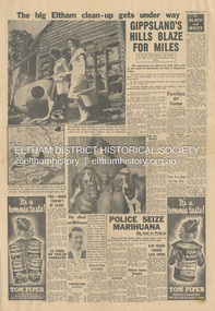
Newspaper - News Clipping, Herald, The big Eltham clean-up gets under way, Herald, 4 March, p3, 1965
Full page newspaper clipping featuring the March 1965 Victorian bushfires. Items include: Photograph - TWO-WOMAN BUCKET BRIGADE, Mrs Henry Marsden (left) and Mrs Moureen Ellis, whose fire-fighting efforts yesterday were highly praised today by their Eltham neighbours, carry out mopping-up operations Photograph - DOGS MADE HOMELESS by the fire in North Eltham yesterday are being cared for at First-Constable Doug. Mummery's kennels at Eltham and here is kennel maid Helen Oliver, 17, with some of them today. The two basset hounds are owned by Mr Bill Guy who lost about 100 daschund and basset hound puppies and dogs in the fire. Photograph - He died at Eltham [Picture of John Lawrence Coleman] Builder Mr John Lawrence Coleman, 31, of Main Rd., Eltham, one of three men burnt to death yesterday in the fire at North Eltham. The other two were XXXXX, 33 who lives opposite the Colemans and Mr William Elwers, 64 of Batman Rd., Eltham. John Lawrence Coleman (1934-1965) born January 10, was the son of Raymond John Coleman and Hanna May (Gillet) Coleman. He married Margaret Frances Dare in 1955 and was the father of two children. He died whilst attempting to rescue an older man trapped in the bushfire at North Eltham on March 3, 1965 Other news stories of the day: Bushfires rage in Victoria, Snowy: Three dead (1965, March 4). The Canberra Times (ACT : 1926 - 1995), p. 1. Retrieved May 19, 2022, from http://nla.gov.au/nla.news-article131758981 Includes two photos of the fire in North Eltham “Firemen make for safety as fire rages in Upper Glen Park Road, North Eltham, Victoria. The smoke hides a house.” and “A house explodes into flames at North Eltham, Victoria. Firemen said bottled gas went up.” Canberra Times (ACT : 1926 - 1995), Thursday 4 March 1965, page 1 ________________________________________ Firemen make for safety as fire rages in Upper Glen Park Road. North Eltham. Victoria. The smoke hides a house. A house explodes into flames at North Eltham. Victoria. Firemen said bottled gas went up. Bushfires rage in Victoria, Snowy: Three dead MELBOURNE, Wednesday.—Three people died today in a bush» fire which raged through North Eltham, about 15 miles from Melbourne. The victims were three men. A fourth man is feared to be dead. Another bushfire. sparked off by the heatwave sizzling over south-eastern Australia, is burning out of control in the Kosciusko State Park, in the Snowy Mountains. Firefighters fear that if it reaches pine forests up the Yarrangobilly River, they will be powerless to stop it. The three victims of the North Eltbam fire were trapped by flames in a valley. Their bodies were found only a few yards apart. They were named by police tonight as Mr. George Crowe, 78, of North Eltham, William John Ewers, 64, and John Laurence Coleman, 31, both of Eltham. The other two have not been identified. They are believed to be a man aged about 40 and an 18-year-old youth. At least 12 homes were destroyed by the fire, the worst in Victoria since 1962, when eight lives were lost and hundreds of homes burnt down at Warrandyte. At one time the township of Eltham was threatened, but a cool change swept in from the south and held back the wall of flames. More than 100 dogs, worth about £4,000, died when the fire raced through two kennels in Short Street, Eltham. and Upper Glen Park Road, North Eltham. A trickle of water Residents ran into the streets as the blaze raced towards their houses. Others frantically dug firebreaks around their homes. Mrs. Sue Recourt wept when firemen arrived while she was vainly trying to stop the flames with a trickle of water from the garden hose. A stack of firewood was blazing, but the firemen managed to save the house and rescue four goats. Many homes in Eltham were saved after flames had crept to within feet of their fences. Students at North Eltham State School had to be evacuated when the blaze threatened the building. Fire fighters were severely hampered by lack of water and narrow roads. The blaze, which began in above century heat, turned toward Wattle Glen, where two houses were gutted. Then the flames raced towards Hurstbridge to the north. Firemen battling desperately, controlled the fire late this afternoon. Five forest fires were still burning in Victoria tonight. IN VICTORIA THIS WEEK Tragic lack of central fire authority (1965, March 9). The Canberra Times (ACT : 1926 - 1995), p. 2. Retrieved May 19, 2022, from http://nla.gov.au/nla.news-article131759928 Canberra Times (ACT : 1926 - 1995), Tuesday 9 March 1965, page 2 ________________________________________ IN VICTORIA THIS WEEK Tragic lack of central fire authority From Rohan Rivett It was the worst week for Victorian fire fighters since Black Friday 27 years ago. On that day one pilot up in a spotter plane said afterwards: "It seemed at times that half the State was on fire." This time, for three days on end, Gippsland men, women and children had moments of conviction that their towns would have blackened into anonymity before the weekend was out. The week began with horror at Eltham on the North-eastern edge of Melbourne. Eltham today is something of an artists' colony. Oil painters, water colourists, potters and sculptors proliferate. A number of University folk have emulated the example of Professor MacMahon Ball who pioneered the way by moving to Eltham and carving a home out of the bush in the thirties. Innermost Eltham is barely 14 miles from the G.P.O. Farthest Eltham stretches miles beyond. It served to illustrate the tragi-ludicrous truncation of Victoria's fire control. Part of Eltham is under the protection of the Melbourne Fire Brigade. But this responsibility ceases at some invisible and incomprehensible line — apparently determined by the meanderings of the water mains. At this point everybody's property throughout the rest of Eltham is dependent on the Country Fire Authority. Half an hour before midday on Wednesday, a fire suddenly started on the West side of Upper Glen road on the edge of Eltham. Before the fire brigade could arrive, it was burning on a widening front through timber and high grass north of Eltham. Two wind changes in rapid succession saw the fire leaping Diamond Creek. With a freshening wind it struck home after home in three streets. More than one of them exploded suddenly as if hit by an incendiary bomb. There is no piped gas in the Eltham area, hence many housewives use bottle gas. The flames outside caused the bottles to explode. Altogether twelve homes were completely incinerated and four more were badly damaged. Thirty prize dogs perished. About three hours after the fire started it raced suddenly down a gully hillside trapping an elderly man. Two other men apparently raced to the rescue. Flames caught the three men within yards of each other, not 200 yards off the Upper Glen Park Road where safety lay. They were burned to death. Next evening an angry and convincing secretary of the Fire Brigade Union, Mr. W. M. Webber, came on television and appealed to the people of Victoria to end the ridiculous and dangerous dualism in fire-fighting control. The Eltham fire, he said, had precisely illustrated the situation. The Metropolitan Fire Brigade area touched Eltham, but where the fire had gutted and killed, was just outside its area. Mr. Webber said his union had constantly urged one authority for the State with a complete reorganisation of fire protection. On Wednesday the union had repeated its call for an inquiry into fire protection in Victoria to the Chief Secretary, Mr Rylah. "No matter how close the liaison between the two organisations, there are always divided sections of thinking," Mr. Webber told viewers. "I don't know how much tragedy the com-munity can take before it demands that it is properly protected." Rumours that differences in gauge between taps and hose nozzles (as between the two authorities) accentuated the damage were denied by fire chiefs who said that all appliances were now carrying adaptors so that hoses could be linked to mains everywhere. But there is grave concern in the Metropolitan Fire Brigade's higher councils at the action of several Federal authorities with projects in and around Melbourne. They are installing non-standard equipment without reference to the State authorities or any dovetailing of appliances and equipment. Public alarm was not diminished by the publication on Friday and Saturday of a heart tearing letter from the young widow of John Lawrence Coleman, 31 year old father of two, who had died in the flames apparently trying to rescue the old man trapped in the gully. By that time, a Vast area of Gippsland was in flames and the troops had been sent in to back up the overworked and often helpless fire-fighters. By Saturday, the Leader of the Opposition, Mr. Stoneham, who has previously demanded a Royal Commission into fire-fighting arrangements, repeated his demand. To add to the Chief Secretary's worries he was publicly rebuked for allegedly implying on television that lives had been lost at Eltham because people went to the wrong place at the wrong time. In a letter to the Press, Professor MacMahon Ball pointed out that two of the men involved were experienced bushmen who had gone "to help an old man in great danger fully aware of the danger to themselves". As Victoria faced its sixth day of total State-wide fire ban, it looked likely that even official resistance was not going to silence the demand for one central authority to control the fire fiend. At the moment, the 400 square miles where two million Victorians live in Greater Melbourne are divorced from the rest of the State in planning, communications, equipment and control of personnel. No one doubts the whole-hearted co-operation and willingness to back each other up of the M.F.B. and the C.F.A., both at top-level and among the firemen themselves. However, when a city straggles so deeply into the country side, the absence of a single authority, to oversee and analyse the fire threat as a whole, suggests suicidal policy of divide and fuel. Emphasis of the tragic loss of a member of a pioneering family who died whilst helping others in his communitybushfire, cfa, country fire authority, fire brigrade, glen park road, heroes, john lawrence coleman, north eltham, victorian bushfires - 1965, volunteers, william john elwers, fire fighter, frank martin, george john crowe, ken gaston, orchard avenue, doug mummery, helen oliver, mrs henry marsden, mrs moureen ellis -
 Eltham District Historical Society Inc
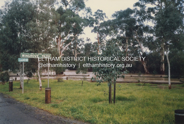
Photograph, Graeme Hardiman, Diamond Creek in flood, Wingrove Park, Main Road, Eltham, 6 June 1989
diamond creek (creek), eltham, floods, floodwater, main road, wingrove park -
 Eltham District Historical Society Inc
Document - Folder, Ness family
James Johnston settled at Kangaroo Ground in 1849. His nephew James Mess joined him and a descendant Robert James Mess changed his surname to Ness. The family became active in all aspects of Kangaroo Ground life. Contents Text (handwritten and transcribed): "The Ness Family, Kangaroo Ground", Joy Ness, 1989. Newspaper article: "True pioneer stock", Diamond Valley News, 2 March 1982. History of the Mess/Ness family Newspaper article: "Ness family are keepers of 140 years of historical knowledge", Diamond Valley News, 4 February 1986. History of Joseph Stephenson and descendants. Newspaper article: "Joy Ness paints native flowers for posterity". Diamond Valley News, 21 October 1986. Life and career of Joy Ness as painter. Newspaper article: "His Cup runneth of with Joy", ?Diamond Valley Leader, 6 December 2000. Bruce and Joy Ness celebrate 60th wedding anniversary. Pencil sketch by Joh Ebeli no date but pre 2004: Portrait of Joy Ness dressed for the Historical Society Parade. Order of Service: Thanksgiving service for the life of Robert Bruce Ness 22 January 1917 / 28 June 2004. Eltham District Historical Society newsletter no date: "Robert Bruce Ness 1917-2004", obituary and extract from Joy Ness's history of the family. Copy of letter from Joh Ebeli to Gwen Orford, no date but ~2004: Describes drawings he made of Robert Bruce Ness when taking part in Diamond Valley Arts Society float and enclosed 3 drawings and a photograph of drawing of the bakers (corner Main Road and York Street Eltham). Eltham District Historical Society newsletter September 2013: "Vale Joy Ness", obituary and extract from Diamond Valley News article of 6 December 2000.Newspaper clippings, A4 photocopies, etcness family kangaroo ground, james johnston, kangaroo ground, pretty hill farm, wellers hotel, betsy sadler, ingleside kangaroo ground, james mess, jane stevenson, ness lane kangaroo ground, view hill kangaroo ground, stte savings bank agency, ruth lettice gosling nee mess, kangaroo ground state school, garden hills kangaroo ground, william mess, joseph mess, isabella mess, james johnson mess, ruth ettie mess, george mess, alexander mess, janes mess, robert david mess, heidelberg agricultural show, diamond creek agricultural show, rober james ness, pearl ness nee mills, william mills, sabina mills, robert bruce ness, beryl ness, vera ness, donald ness, kangaroo ground presbyterian church, kangaroo ground cemetery trust, kangaroo ground tennis club, professor osborne, doctor osborne, joseph stevenson, joy ness, kangaroo ground fire brigade, bruce ness, country fire authority, ship wellington 1837, diamond creek, david christmas, christmas hills, andres harkness, samuel furphy, andrew ross, caledonian gold fields, queenstown now st andrews, mother coleman of kangaroo ground, diamond valley arts society, winifred joy ness, andrew ross museum, eltham art show -
Eltham District Historical Society Inc
Document - Folder, North, Edley
Joseph Benjamin North was a well-known professional musician in Melbourne in late 1800 to mid 1900s, teaching music and playing in what became the Melbourne Symphony Orchestra. He married Lucinda Matilda and their children were Tralford E and Camille D. With friend Leon Lambert, North purchased 60 acres of land around Karingal Drive and Sherbourne Road and built two houses; they paid for a wooden bridge for access. North eventually sold his house to a family named Green but later the land was sold to the Shire of Eltham, and it is now known as Meruka Park, and the house, Meruka House; Alan Gardner named the park. After Lambert's death, his property was bought by Fred Warne. Edley North was born in 1835, and died 26 March 1923; he married Caroline North, born 1835, died 23 July 1922. Edley's family migrated from England in 1859, settling in Adelaide. He was granted an allotment of 221 acres on Phillip Island 1868-1870. on 7 April 1874 he travelled to Pine Lodge and later moved his wife and five children. He and Caroline later moved to a small farm, Willow Grove in Eltham, purchased between 1905 and 1910 (first mentioned in the rate book in 1908 as being a house and 10 acres on Susan Street, and would also have had frontage on Brougham Street); Their daughter Violet Alice inherited it; she married Walter J Dobson around 1921; he died on 25 March 1948 aged 77 and Violet on 4 January 1947. Willow Grove was later purchased by A George and P Audrey Hester April/May 1947. Edley, Caroline and Violet are all buried in Eltham Cemetery. Marjorie Mary North was born in 1909 ; the family travelled in a horse-drawn waggon from Fitzroy to spend weekends in their little holiday house in Sherbourne Road on 10 acres of land. In 1933, she married Tralford Norman whose parents owned 62 acres of land including Meruka Park. Marjorie and Tralford lived in Looker Road, Montmorency; she died 7 February 2003. Contents Newspaper article: "When life centred on a weekender", Diamond Valley News, 25 September 1984, memories of Montmorency of Marjorie North. Newspaper article: "Worse floods seem likely", Diamond Valley News, 25 September 1984, floods in Eltham Handwritten notes: Information by Marjorie North's about her grandmother, September 1989. Handwritten and typed transcript: "J. B. North", by Marjorie North, history of Joseph Benjamin North. Letter: From Monash University to Marjorie North, 15 November 1989, being unable to assist with her enquiry about the meaning of name [unspecified in the letter but possibly Meruka] Letter: June Stanton (nee Hester) to Eltham District Historical Society, 17 February 1993, seeking information on her great grandfather Edley North and wife Caroline. Christmas card [attached to letter from June Stanton]: Line drawing Eltham Primary School 1856, text history of school Letter: Eltham Historical Society to June Hester, 11 June 1993, providing information held by the Society. Letter: Nancy Chandler (nee Williamson) to Jo McCormick 18 March 2001, providing information about Edley and Carline North, her great grandparents. Email: Patsy Moppett to Eltham District Historical Society October 2010: A photograph of Edley and Caroline North found, wish to return it to family. Family tree: North/Dobson family. Death notice: Marjorie May North, died 7 February 2003.Newspaper clippings, A4 photocopies, etcmarjorie north, tralford norman, sherbourne road montmorency, looker road montmorency, briar hill, montmorency, catholic ladies college, merton hall, melbourne girls grammar school, ivanhoe girls grammar school, wesley college, meruka park, st helena road, st faith's anglican church montmorency, william sapsford, floods in eltham, joseph benjamin north, leon lambert, melbourne symphony orchestra, karingal drive, meruka house, alan gardner, lucinda matilda north, tralford e north, camille d north, montmorency cricket club, diamond creek, eltham railway station, judge book village, fred warne, edley north, caroline north, eltham cemetery., violet alice dobson (nee north), willow farm eltham, edley north family tree, walter john dobson family tree, nancy chandler (nee williamson), pine lodge, elijah north -
 Eltham District Historical Society Inc
Document - Photocopy, Survey Fleld Notes of Part of Crown Portion 13, Section 4 at Eltham, Parish of Nillumbik, County of Evelyn, 1902-1903
Main Road, Henry Street to Diamond Street; Silver Street to Bible Street Application No. 0337771902, 1903, arthur street, bible street, bird street, diamond creek (creek), diamond street, eltham, eltham railway station, henry street, main road, silver street, survey plan, vine street, application 33777, map -
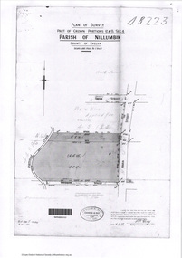 Eltham District Historical Society Inc
Document - Photocopy, Survey Fleld Notes of Part of Crown Portions 12 & 13, Section 4 at Eltham, Parish of Nillumbik, County of Evelyn, 6 May 1929
... Portion of land bounded by: Main Road, York Street, Diamond..., Diamond Creek, Swan Street Application 48223 P.N. Guy, Licensed ...Portion of land bounded by: Main Road, York Street, Diamond Creek, Swan Street Application 48223 P.N. Guy, Licensed Surveyor, 6 May 1929application 48223, diamond creek (creek), eltham, main road, map, survey plan, swan street, york street -
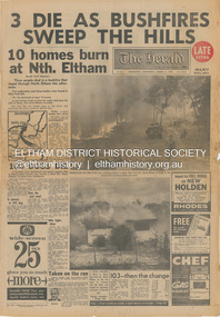 Eltham District Historical Society Inc
Newspaper - Newspaper articles, The Herald, 3 Die as Bushfires Sweep the Hill: 10 homes burn at Nth. Eltham, The Herald, Wednesday, March 3, p1, 1965
Various news articles pertaining to the January 1965 Victorian bushfires specifically with a focus on fires at Eltham North. Specific Eltham Shire districts mentioned include Eltham North and veteran Herald staff photographer Bert Rodda on page 1 • 3 Die as Bushfires Sweep the Hill: 10 homes burn at Nth. Eltham, p1 (Illust.) • 100 dogs die, p1 • Taken on the run, p1 (Illust.) • Fire runs wild at Eltham, p3 (Illust.) • 10-mile front out of control; Gippsland area ablaze, p3 • Trapped, but saved by wind, p3 tom fielding collection, victorian bushfires - 1965, victorian bushfires – 1965, eltham north, bert rodda, glen park road, short road, research (vic.), wattle glen, diamond creek, warrandyte, eltham, gippsland, mrs g. maher, bill dancy, eltham north store, bushfire damage - buildings -
Eltham District Historical Society Inc
Document - Folder, Partington family
Charles Partington married Ellen Whatmough; they and their children, Robert and James, came to Australia in 1857 because Ellen's brother, Robert Whatmough, had come here in 1841. Whatmough was Melbourne's first lamplighter while also working in John Batman's Spencer Street orchard; he moved in 1842 to establish an orchard in Greensborough. Both Partington boys died soon after the family arrived at Greensborough but later two daughters were born, Prudina and Maria, and five sons, including William . On arrival Charles Partington began work for Mr Flintoff at Black Hills and was later toll keeper on what is now Watsonia Road. He was later a successful orchardist. William Partington married Annie-May Medhurst, daughter of David Medhurst and Martha Ruston, daughter of Peter Ruston who had settled in Greensborough in the 1850s after working for Mr Hooper in Darebin Creek, then moved to Panton Hill in 1866 working as a carrier. The Rustons had six children, including Martha and James. Martha married David Medhurst in 1882 who was the son of David Medhurst and Charity Jane Pink. After David's death, Charity Jane married George Wescott. David and Martha Medhurst had eight children, including Annie May. They bought land in Main Street, Greensborough and set up as a greengrocer. William and Annie-May Partington's family home, Willis Vale, purchased from Mr Meagher by William's father, Charles; it was built by Meagher in 1839 but destroyed by vandals in 1966 after being compulsory purchased for parkland now called Partington's Flat. Their children were Eva, Grace, Alan, Jessie, and Jack. They attended Greensborough Primary School. Alan married Wyn. Contents Newspaper article: "Link with the past", Diamond Valley News, 21 February 1984. Alan Partington's research on Robert Whatmough, early settler in Greensborough, and his brother-in-law Charles Partington. Newspaper article: "How early families linked up", Diamond Valley News, 28 February 1984. Alan Partington's research into the Ruston and Medhurst families. Newspaper article: "Old days recalled", Diamond Valley News, 13 March 1984. Alan Partington's research in the Partington family.Newspaper clippings, A4 photocopies, etcalan partington, robert whatmough, watmough park greensborough, robert partington, james partington, elen partington nee whatmough, road tolls watsonia road, prudina partington, maria partington, william partington, willis vale, partington's flat greensborugh, mr meagher of greensborough, apollo parkways estate, charles partington, annie-may partington nee medhurst, david medhurst, martha medhurst (nee ruston), jack medhurst, peter ruston, hooper of darebin creek, greensborough hotel, james ruston, charity jane medhurst (nee pink), main street greensborough, eva partington, grace partington, jessie partington, jack partington, orchards in plenty river area, greensborough primary school, wyn partington, flintoff of black hills -
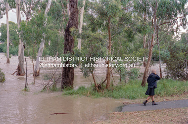 Eltham District Historical Society Inc
Photograph, Diamond Creek floodwaters near the Main Road Bridge, Eltham, Jan-Feb 2005, 2005
... melbourne diamond creek eltham floods main road bridge Kodak GC400-8 ...Roll of 35mm colour negative film, 7 stripsKodak GC400-8diamond creek, eltham, floods, main road bridge -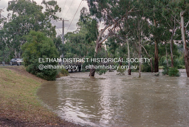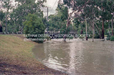
 Eltham District Historical Society Inc
Newsletter, Eltham District Historical Society, Newsletter, No. 240 June 2018
Contents: • Past, Present, Future by Jim Connor • Our Next Meeting – Wednesday 13th June 2018 • July Excursion – Along the Diamond Creek • Eltham 1950s – Childhood Reminiscences – Part 4 by Ann Constable • Lavender Park Road Mysteries by Heather Eastman • Was the David Clark “Victoria’s Mayflower”? by Irene Kearsey • Jalna Yoghurt by Wendy Wilson • Office Bearers 2018-2019 • Subscriptions • Andrew Ross Museum • New Life Members by Russell Yeoman • Contacts for the Eltham District Historical Society The Shire of Eltham Historical Society was formed in October 1967. The first newsletter of the Society was issued May 1978 and has been published continuously ever since on a bi-monthly basis. With the cessation of the Shire of Eltham in late 1994, the Society's name was revised to Eltham District Historical Society and this name first appeared with issue No. 103, July 1995. The collection of the Society's newsletters provides a valuable resource on the history of the Society's activities, office bearers and committee members, guest speakers and subjects of historical interest pertinent to the former Shire of Eltham and the Eltham District.A4 newsletter distributed to membersnewsletter, eltham district historical society -
 Eltham District Historical Society Inc
Journal, Peter Doughtery, ArtStreams: Arts & Culture in Banyule, Darebin, Manningham, Nillumbik and Whittlesea; Vol. 5, No. 1, Mar-Apr 2000, 2000
Vol. 5, No. 1, Mar-Apr 2000 CONTENTS ON THE ROAD The Car at Heide 3 ON TOP OF THE WORLD Dandenong Ranges Folk Festival 5 INTERVIEW Felicity Gordon 7 SOUNDS OF HARMONY Gyuto Monks in Eltham 10 BANYULE FESTIVAL 13 WERE ST HILL CLIMB 15 BOROONDARA WRITERS' FESTIVAL 16 WARRANDYTE VILLAGE FESTIVAL 18 DIAMOND CREEK TOWN FAIR 19 TEMPLESTOWE VILLAGE FESTIVAL 20 RECIPES From leading Chefs 21 CAIRO TO CRACOW Middle Eastern Music at Montsalvat 22 POETRY 23 FESTIVAL OF KITES 24 BOOK REVIEW By Michele Lonsdale 25 CD REVIEWS 27 ARTIN ABOUT 28 WINING & DINING 30 ARTISTS SERVICES 32 "Peter Dougherty has been involved in the local art scene for many years. As publisher and editor of the arts magazine Artstreams, his comments on the various branches of the arts are widely respected. His "The Arts" column in the Diamond Valley Leader presents a brief summary for a much wider cross section of the local community. Peter also operates his own gallery and the Artstreams Cafe at the St Andrews market. Peter has a wealth of knowledge about present day and historical aspects of local art and artists." - Eltham District Historical Society Newsletter No. 161, March 2005Colour front and back cover with feature articles and literary pieces with photographs and advertisements printed in black and white. 36 pages, 30 cm. Vol. 1, no. 1 (Nov. 1996) - Vol. 10, no. 5 (summer ed. 2005/06) art streams, carly young, plenty views golf park, dynamic vegies, dandenong ranges folk festival, felicity gordon, sounds of global harmony, banyule festival, rosanna fire station community house, bulleen art & garden centre, were street cafe, were street hill climb, bahnhof cafe, walkers wheels, peter glass, eltham wiregrass gallery, boroondara writers festival, warrandyte festival, diamond creek town fair, templestowe village festival, willy wonkas ice cream, gourmet food, ciaro to cracow, fleur de feliss florist, mia mia gallery, festival of kites, bi-wize quality paints, kinglake gallery, andy cowan, wild dog hill studio, montsalvalt, ian collard, geoff achison, bridget allen, thompsons pharmacy, volumes -
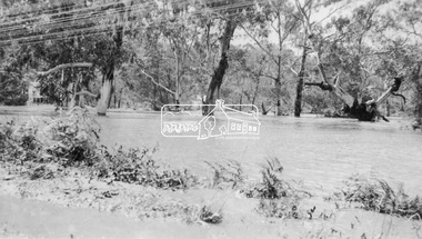 Eltham District Historical Society Inc
Negative - Photograph, Floodwaters, Diamond Creek, Eltham, 1934
The Diamond Creek in flood near the Main Road bridge at Eltham, Victoria. The Yarra also was in flood. In early December 1934 the "Greatest flood in the history of the Yarra" occured, according to The Argus newspaper. Bridges and houses were swept away with hundreds of people left homeless across the state. The historic 1934 flood of the Diamond Creek and Yarra River set the criteria for future planning with respect to flood water rise. Noted on reverse of print - Copied by Hugh Fisher, 82 Lygon St., BrunswickThis photo forms part of a collection of photographs gathered by the Shire of Eltham for their centenary project book,"Pioneers and Painters: 100 years of the Shire of Eltham" by Alan Marshall (1971). The collection of over 500 images is held in partnership between Eltham District Historical Society and Yarra Plenty Regional Library (Eltham Library) and is now formally known as the 'The Shire of Eltham Pioneers Photograph Collection.' It is significant in being the first community sourced collection representing the places and people of the Shire's first one hundred years.Digital image 4 x 5 inch B&W Neg (2 frames on one neg) Print 9 x 15.5 cmOn reverse of print - "Copied by Hugh Fisher, 82 Lygon St., Brunswick" (for Shire of Eltham)sepp, shire of eltham pioneers photograph collection, eltham, floods, 1934 flood, diamond creek (creek), floodwater -
 Eltham District Historical Society Inc
Photograph, Joy Chapman, Miss Eltham, April 1965, Apr 1965
My Recollections of Eltham Past by Margaret Joy Harding (nee Joy Chapman.) My family of Elizabeth and Alec Chapman moved to Eltham in 1946 into a cottage on the opposite side of the Diamond Creek from where the little train now operates in the Lower Park. At that time Eltham truly was a country town and the Pub was the main meeting place for most inhabitants on a Saturday afternoon in the beer garden. I attended Eltham Primary School where I started as a 4-year-old (my birthday being slightly after the mid-year intake) that happened then. My mother spent a lot of days taking me back to school when I had dismissed myself and walked the one kilomtre home alone. Bremner's Common (now Wingrove Park) was a big attraction with its dam and tad poling which I found much more entertaining than school. (Mrs Bremner ran a Service Station on the site of the current one). Another attraction at this site was the circus that came a couple of times a year. Watching them put up the circus tent was very interesting and even more of an attraction was the feeding of the Lions in cages and the monkeys and elephants among the other animals that are not found in a circus these days. At school then we were provided with hot chocolate at morning recess where the mothers would prepare it in the shelter shed. The only form of classroom heating was an open fire. Worse was the warm milk given in the summer months. By the time I was near finishing at Primary school we used to be able to walk along the Main Road at lunchtime to Mrs. Mitchell's shop to a delicious hot pie. As I recall there was no supervision for this departure from the school grounds. It is interesting that some of the other children I started school with I still have contact with, in fact one is a very good friend although now living in Perth. That is the other thing about Eltham; many who grew up here continue to live in the area. Following primary school, the natural progression was to Eltham High School. There was only the main building at that time and I can remember our first assembly at the front entrance. During the time I was at High School several new class rooms were added and the school hall. I remember the musical plays such as HMS Pinafore and other classical musicals being performed. I also remember countless hours doing marching practice. The main street shops when I was young consisted of the Blue Gum milk bar at the far end, a Grocery store and a shoe maker where Coles currently stands. Opposite there was Lyon's Garage. They also provided a bus service and when we got off the train this little bus would tour the back streets taking each individual to their home, sometimes this could take quite considerable time. There was also a Black Smith next to the Chiropractic Practice opposite Alistair Knox Park, another Milk Bar/General Store on the comer of Bridge Street/Main Road where a shop currently still operates. There was also a Butcher's shop down from the pub opposite Franklin Street. The only doctor was next to the courthouse on the other side of Brougham Street. On Saturday afternoon I was occasionally allowed to go the movies in the Town Hall which also stood on the site of the Coles centre. Often the Fire Alarm would sound and everyone would run outside to watch the fire truck leave with the volunteers clutching on the back. The other attraction during summer of course was the swimming pool which was a small concrete pool filled with water pumped from the Diamond Creek, sometimes it was like a mud puddle so for me the nearer to home Yarra/Diamond Creek junction was a much better option. We swam in the water hole which was quite deep and with fallen trees and sometimes carcasses of cows and kangaroos floating past. As recreation, the churches were another attraction for the Sunday school picnics to Mordialloc in the back of the moving van with benches tied into the back for us to "sit" on. Too bad when we went around a corner! In the early days we had an Ice Man deliver the ice once a week for "refrigeration". The green grocer came around in a horse and cart as did the milkman and the bread was delivered but I constantly got into trouble for eating the middle out on the way from the box it was delivered to in Mt Pleasant road across the paddock. The milkman finally would not come down our street after his horse bolted one morning and took off across the paddock. We also had the "Pan Man" come weekly and whose visit I would avoid. Our nearest shop was where the flower stall is located opposite the Lower Park. It consisted of a Tea Room and Milk Bar. There was a Public Telephone there which was the only contact to anyone else. We were a one car family so my mother’s movements were very limited as the Eltham Station was a couple of kilometres away and a trip to the city was an event. Being an only child growing up was a little lonely however rambling along the creek with my Mum, picking mushrooms and picking cherry plums for jam and the dogs catching rabbits which we ate if we could get them away from the dogs. We also liked to go into the Lower Park during school holidays when the Greek people came to camp and they would sing and dance around the camp fire and it all seemed so different to us as this was early days of immigration. Childhood was relatively simple and carefree and I wish the kids of today had the freedom of my youth and the healthy outdoor lifestyle of the "olden days". SHOW GIRL COMPETITION In 1965 Eltham was more like a country town than the suburb it has become today. People knew each other, if not personally then certainly of the family name. The big event for the year was a Gymkhana or show at Lower Eltham Park. I can remember marching as a teenager from the town centre to the park in the marching girls with the decorated floats. In 1965, just on a whim on the day, I decided to enter the Miss Eltham Show Girl which was a part of the festivities at the park. I seem to remember that the show mainly consisted of horse events, cattle judging and dog show. As I had not given any serious thought to entering the competition, I wore a suit that I had for work which was brown wool, with a coffee coloured shirt under, black shoes, bag, and gloves but no hat. I duly paraded for the judges and much to my surprise I was announced the winner. I eventually went on to compete at the Miss Victoria Show Girl competition which was held at the Royal Melbourne Show. There I met many country girls who were representing their rural Victoria home. I made it into a final round of judging but I think justice prevailed when someone from a country background was crowned. It was fun to go into the show as I had not really been before and to see the displays of handcraft, cooking and wood chopping events was great as well as the judging of farm animals interesting. It is hard to remember the Eltham I grew up in. The Lyons Garage company bus that actually drove you home (or close to it) when we got off the train at night. The Eltham Hotel on a Saturday afternoon a usual social meeting place where people just sat and chatted. The pictures held in the Town Hall and when the fire alarm sounded all the men just jumped up and ran to help. Suburbia has now swallowed most of that life but thankfully we at least do have the trestle bridge and parkland. Digital file only - Black and white photo print on loan for scanning by EDHSalec chapman, annie bremner, blacksmith, bremner's flat, brougham steet, bus services, circus, diamond creek, dianne bell, doctor bradbury, easter gymkhana, elizabeth chapman, eltham high school, eltham hotel, eltham lower park, eltham public hall, eltham state school, eltham trestle bridge, general store, grace mitchell, ice man, joy chapman, lyons garage, margaret harding, milk bar, miss eltham 1965, miss victoria show girl, mount pleasant road, pan man, rodda parade, shops, show girl competition, swimming pool, water hole, yarra river -
 Eltham District Historical Society Inc
Photograph, Joy Chapman parading before the judges, Miss Eltham 1965, Apr 1965
My Recollections of Eltham Past by Margaret Joy Harding (nee Joy Chapman.) My family of Elizabeth and Alec Chapman moved to Eltham in 1946 into a cottage on the opposite side of the Diamond Creek from where the little train now operates in the Lower Park. At that time Eltham truly was a country town and the Pub was the main meeting place for most inhabitants on a Saturday afternoon in the beer garden. I attended Eltham Primary School where I started as a 4-year-old (my birthday being slightly after the mid-year intake) that happened then. My mother spent a lot of days taking me back to school when I had dismissed myself and walked the one kilomtre home alone. Bremner's Common (now Wingrove Park) was a big attraction with its dam and tad poling which I found much more entertaining than school. (Mrs Bremner ran a Service Station on the site of the current one). Another attraction at this site was the circus that came a couple of times a year. Watching them put up the circus tent was very interesting and even more of an attraction was the feeding of the Lions in cages and the monkeys and elephants among the other animals that are not found in a circus these days. At school then we were provided with hot chocolate at morning recess where the mothers would prepare it in the shelter shed. The only form of classroom heating was an open fire. Worse was the warm milk given in the summer months. By the time I was near finishing at Primary school we used to be able to walk along the Main Road at lunchtime to Mrs. Mitchell's shop to a delicious hot pie. As I recall there was no supervision for this departure from the school grounds. It is interesting that some of the other children I started school with I still have contact with, in fact one is a very good friend although now living in Perth. That is the other thing about Eltham; many who grew up here continue to live in the area. Following primary school, the natural progression was to Eltham High School. There was only the main building at that time and I can remember our first assembly at the front entrance. During the time I was at High School several new class rooms were added and the school hall. I remember the musical plays such as HMS Pinafore and other classical musicals being performed. I also remember countless hours doing marching practice. The main street shops when I was young consisted of the Blue Gum milk bar at the far end, a Grocery store and a shoe maker where Coles currently stands. Opposite there was Lyon's Garage. They also provided a bus service and when we got off the train this little bus would tour the back streets taking each individual to their home, sometimes this could take quite considerable time. There was also a Black Smith next to the Chiropractic Practice opposite Alistair Knox Park, another Milk Bar/General Store on the comer of Bridge Street/Main Road where a shop currently still operates. There was also a Butcher's shop down from the pub opposite Franklin Street. The only doctor was next to the courthouse on the other side of Brougham Street. On Saturday afternoon I was occasionally allowed to go the movies in the Town Hall which also stood on the site of the Coles centre. Often the Fire Alarm would sound and everyone would run outside to watch the fire truck leave with the volunteers clutching on the back. The other attraction during summer of course was the swimming pool which was a small concrete pool filled with water pumped from the Diamond Creek, sometimes it was like a mud puddle so for me the nearer to home Yarra/Diamond Creek junction was a much better option. We swam in the water hole which was quite deep and with fallen trees and sometimes carcasses of cows and kangaroos floating past. As recreation, the churches were another attraction for the Sunday school picnics to Mordialloc in the back of the moving van with benches tied into the back for us to "sit" on. Too bad when we went around a corner! In the early days we had an Ice Man deliver the ice once a week for "refrigeration". The green grocer came around in a horse and cart as did the milkman and the bread was delivered but I constantly got into trouble for eating the middle out on the way from the box it was delivered to in Mt Pleasant road across the paddock. The milkman finally would not come down our street after his horse bolted one morning and took off across the paddock. We also had the "Pan Man" come weekly and whose visit I would avoid. Our nearest shop was where the flower stall is located opposite the Lower Park. It consisted of a Tea Room and Milk Bar. There was a Public Telephone there which was the only contact to anyone else. We were a one car family so my mother’s movements were very limited as the Eltham Station was a couple of kilometres away and a trip to the city was an event. Being an only child growing up was a little lonely however rambling along the creek with my Mum, picking mushrooms and picking cherry plums for jam and the dogs catching rabbits which we ate if we could get them away from the dogs. We also liked to go into the Lower Park during school holidays when the Greek people came to camp and they would sing and dance around the camp fire and it all seemed so different to us as this was early days of immigration. Childhood was relatively simple and carefree and I wish the kids of today had the freedom of my youth and the healthy outdoor lifestyle of the "olden days". SHOW GIRL COMPETITION In 1965 Eltham was more like a country town than the suburb it has become today. People knew each other, if not personally then certainly of the family name. The big event for the year was a Gymkhana or show at Lower Eltham Park. I can remember marching as a teenager from the town centre to the park in the marching girls with the decorated floats. In 1965, just on a whim on the day, I decided to enter the Miss Eltham Show Girl which was a part of the festivities at the park. I seem to remember that the show mainly consisted of horse events, cattle judging and dog show. As I had not given any serious thought to entering the competition, I wore a suit that I had for work which was brown wool, with a coffee coloured shirt under, black shoes, bag, and gloves but no hat. I duly paraded for the judges and much to my surprise I was announced the winner. I eventually went on to compete at the Miss Victoria Show Girl competition which was held at the Royal Melbourne Show. There I met many country girls who were representing their rural Victoria home. I made it into a final round of judging but I think justice prevailed when someone from a country background was crowned. It was fun to go into the show as I had not really been before and to see the displays of handcraft, cooking and wood chopping events was great as well as the judging of farm animals interesting. It is hard to remember the Eltham I grew up in. The Lyons Garage company bus that actually drove you home (or close to it) when we got off the train at night. The Eltham Hotel on a Saturday afternoon a usual social meeting place where people just sat and chatted. The pictures held in the Town Hall and when the fire alarm sounded all the men just jumped up and ran to help. Suburbia has now swallowed most of that life but thankfully we at least do have the trestle bridge and parkland. Digital file only - Black and white photo print on loan for scanning by EDHSalec chapman, annie bremner, blacksmith, bremner's flat, brougham steet, bus services, circus, diamond creek, dianne bell, doctor bradbury, easter gymkhana, elizabeth chapman, eltham high school, eltham hotel, eltham lower park, eltham public hall, eltham state school, eltham trestle bridge, general store, grace mitchell, ice man, joy chapman, lyons garage, margaret harding, milk bar, miss eltham 1965, miss victoria show girl, mount pleasant road, pan man, rodda parade, shops, show girl competition, swimming pool, water hole, yarra river -
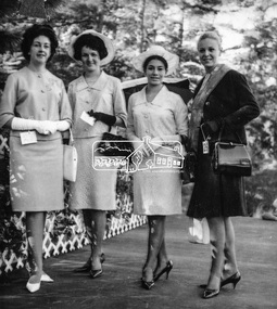 Eltham District Historical Society Inc
Photograph, Joy Chapman, Miss Eltham 1965 with other contestants, Apr 1965
My Recollections of Eltham Past by Margaret Joy Harding (nee Joy Chapman.) My family of Elizabeth and Alec Chapman moved to Eltham in 1946 into a cottage on the opposite side of the Diamond Creek from where the little train now operates in the Lower Park. At that time Eltham truly was a country town and the Pub was the main meeting place for most inhabitants on a Saturday afternoon in the beer garden. I attended Eltham Primary School where I started as a 4-year-old (my birthday being slightly after the mid-year intake) that happened then. My mother spent a lot of days taking me back to school when I had dismissed myself and walked the one kilomtre home alone. Bremner's Common (now Wingrove Park) was a big attraction with its dam and tad poling which I found much more entertaining than school. (Mrs Bremner ran a Service Station on the site of the current one). Another attraction at this site was the circus that came a couple of times a year. Watching them put up the circus tent was very interesting and even more of an attraction was the feeding of the Lions in cages and the monkeys and elephants among the other animals that are not found in a circus these days. At school then we were provided with hot chocolate at morning recess where the mothers would prepare it in the shelter shed. The only form of classroom heating was an open fire. Worse was the warm milk given in the summer months. By the time I was near finishing at Primary school we used to be able to walk along the Main Road at lunchtime to Mrs. Mitchell's shop to a delicious hot pie. As I recall there was no supervision for this departure from the school grounds. It is interesting that some of the other children I started school with I still have contact with, in fact one is a very good friend although now living in Perth. That is the other thing about Eltham; many who grew up here continue to live in the area. Following primary school, the natural progression was to Eltham High School. There was only the main building at that time and I can remember our first assembly at the front entrance. During the time I was at High School several new class rooms were added and the school hall. I remember the musical plays such as HMS Pinafore and other classical musicals being performed. I also remember countless hours doing marching practice. The main street shops when I was young consisted of the Blue Gum milk bar at the far end, a Grocery store and a shoe maker where Coles currently stands. Opposite there was Lyon's Garage. They also provided a bus service and when we got off the train this little bus would tour the back streets taking each individual to their home, sometimes this could take quite considerable time. There was also a Black Smith next to the Chiropractic Practice opposite Alistair Knox Park, another Milk Bar/General Store on the comer of Bridge Street/Main Road where a shop currently still operates. There was also a Butcher's shop down from the pub opposite Franklin Street. The only doctor was next to the courthouse on the other side of Brougham Street. On Saturday afternoon I was occasionally allowed to go the movies in the Town Hall which also stood on the site of the Coles centre. Often the Fire Alarm would sound and everyone would run outside to watch the fire truck leave with the volunteers clutching on the back. The other attraction during summer of course was the swimming pool which was a small concrete pool filled with water pumped from the Diamond Creek, sometimes it was like a mud puddle so for me the nearer to home Yarra/Diamond Creek junction was a much better option. We swam in the water hole which was quite deep and with fallen trees and sometimes carcasses of cows and kangaroos floating past. As recreation, the churches were another attraction for the Sunday school picnics to Mordialloc in the back of the moving van with benches tied into the back for us to "sit" on. Too bad when we went around a corner! In the early days we had an Ice Man deliver the ice once a week for "refrigeration". The green grocer came around in a horse and cart as did the milkman and the bread was delivered but I constantly got into trouble for eating the middle out on the way from the box it was delivered to in Mt Pleasant road across the paddock. The milkman finally would not come down our street after his horse bolted one morning and took off across the paddock. We also had the "Pan Man" come weekly and whose visit I would avoid. Our nearest shop was where the flower stall is located opposite the Lower Park. It consisted of a Tea Room and Milk Bar. There was a Public Telephone there which was the only contact to anyone else. We were a one car family so my mother’s movements were very limited as the Eltham Station was a couple of kilometres away and a trip to the city was an event. Being an only child growing up was a little lonely however rambling along the creek with my Mum, picking mushrooms and picking cherry plums for jam and the dogs catching rabbits which we ate if we could get them away from the dogs. We also liked to go into the Lower Park during school holidays when the Greek people came to camp and they would sing and dance around the camp fire and it all seemed so different to us as this was early days of immigration. Childhood was relatively simple and carefree and I wish the kids of today had the freedom of my youth and the healthy outdoor lifestyle of the "olden days". SHOW GIRL COMPETITION In 1965 Eltham was more like a country town than the suburb it has become today. People knew each other, if not personally then certainly of the family name. The big event for the year was a Gymkhana or show at Lower Eltham Park. I can remember marching as a teenager from the town centre to the park in the marching girls with the decorated floats. In 1965, just on a whim on the day, I decided to enter the Miss Eltham Show Girl which was a part of the festivities at the park. I seem to remember that the show mainly consisted of horse events, cattle judging and dog show. As I had not given any serious thought to entering the competition, I wore a suit that I had for work which was brown wool, with a coffee coloured shirt under, black shoes, bag, and gloves but no hat. I duly paraded for the judges and much to my surprise I was announced the winner. I eventually went on to compete at the Miss Victoria Show Girl competition which was held at the Royal Melbourne Show. There I met many country girls who were representing their rural Victoria home. I made it into a final round of judging but I think justice prevailed when someone from a country background was crowned. It was fun to go into the show as I had not really been before and to see the displays of handcraft, cooking and wood chopping events was great as well as the judging of farm animals interesting. It is hard to remember the Eltham I grew up in. The Lyons Garage company bus that actually drove you home (or close to it) when we got off the train at night. The Eltham Hotel on a Saturday afternoon a usual social meeting place where people just sat and chatted. The pictures held in the Town Hall and when the fire alarm sounded all the men just jumped up and ran to help. Suburbia has now swallowed most of that life but thankfully we at least do have the trestle bridge and parkland. Digital file only - Black and white photo print on loan for scanning by EDHSalec chapman, annie bremner, blacksmith, bremner's flat, brougham steet, bus services, circus, diamond creek, dianne bell, doctor bradbury, easter gymkhana, elizabeth chapman, eltham high school, eltham hotel, eltham lower park, eltham public hall, eltham state school, eltham trestle bridge, general store, grace mitchell, ice man, joy chapman, lyons garage, margaret harding, milk bar, miss eltham 1965, miss victoria show girl, mount pleasant road, pan man, rodda parade, shops, show girl competition, swimming pool, water hole, yarra river -
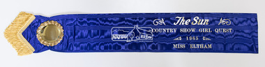 Eltham District Historical Society Inc
Photograph, Peter Pidgeon, The original Miss Eltham 1965 sash, 17 May 2019
My Recollections of Eltham Past by Margaret Joy Harding (nee Joy Chapman.) My family of Elizabeth and Alec Chapman moved to Eltham in 1946 into a cottage on the opposite side of the Diamond Creek from where the little train now operates in the Lower Park. At that time Eltham truly was a country town and the Pub was the main meeting place for most inhabitants on a Saturday afternoon in the beer garden. I attended Eltham Primary School where I started as a 4-year-old (my birthday being slightly after the mid-year intake) that happened then. My mother spent a lot of days taking me back to school when I had dismissed myself and walked the one kilomtre home alone. Bremner's Common (now Wingrove Park) was a big attraction with its dam and tad poling which I found much more entertaining than school. (Mrs Bremner ran a Service Station on the site of the current one). Another attraction at this site was the circus that came a couple of times a year. Watching them put up the circus tent was very interesting and even more of an attraction was the feeding of the Lions in cages and the monkeys and elephants among the other animals that are not found in a circus these days. At school then we were provided with hot chocolate at morning recess where the mothers would prepare it in the shelter shed. The only form of classroom heating was an open fire. Worse was the warm milk given in the summer months. By the time I was near finishing at Primary school we used to be able to walk along the Main Road at lunchtime to Mrs. Mitchell's shop to a delicious hot pie. As I recall there was no supervision for this departure from the school grounds. It is interesting that some of the other children I started school with I still have contact with, in fact one is a very good friend although now living in Perth. That is the other thing about Eltham; many who grew up here continue to live in the area. Following primary school, the natural progression was to Eltham High School. There was only the main building at that time and I can remember our first assembly at the front entrance. During the time I was at High School several new class rooms were added and the school hall. I remember the musical plays such as HMS Pinafore and other classical musicals being performed. I also remember countless hours doing marching practice. The main street shops when I was young consisted of the Blue Gum milk bar at the far end, a Grocery store and a shoe maker where Coles currently stands. Opposite there was Lyon's Garage. They also provided a bus service and when we got off the train this little bus would tour the back streets taking each individual to their home, sometimes this could take quite considerable time. There was also a Black Smith next to the Chiropractic Practice opposite Alistair Knox Park, another Milk Bar/General Store on the comer of Bridge Street/Main Road where a shop currently still operates. There was also a Butcher's shop down from the pub opposite Franklin Street. The only doctor was next to the courthouse on the other side of Brougham Street. On Saturday afternoon I was occasionally allowed to go the movies in the Town Hall which also stood on the site of the Coles centre. Often the Fire Alarm would sound and everyone would run outside to watch the fire truck leave with the volunteers clutching on the back. The other attraction during summer of course was the swimming pool which was a small concrete pool filled with water pumped from the Diamond Creek, sometimes it was like a mud puddle so for me the nearer to home Yarra/Diamond Creek junction was a much better option. We swam in the water hole which was quite deep and with fallen trees and sometimes carcasses of cows and kangaroos floating past. As recreation, the churches were another attraction for the Sunday school picnics to Mordialloc in the back of the moving van with benches tied into the back for us to "sit" on. Too bad when we went around a corner! In the early days we had an Ice Man deliver the ice once a week for "refrigeration". The green grocer came around in a horse and cart as did the milkman and the bread was delivered but I constantly got into trouble for eating the middle out on the way from the box it was delivered to in Mt Pleasant road across the paddock. The milkman finally would not come down our street after his horse bolted one morning and took off across the paddock. We also had the "Pan Man" come weekly and whose visit I would avoid. Our nearest shop was where the flower stall is located opposite the Lower Park. It consisted of a Tea Room and Milk Bar. There was a Public Telephone there which was the only contact to anyone else. We were a one car family so my mother’s movements were very limited as the Eltham Station was a couple of kilometres away and a trip to the city was an event. Being an only child growing up was a little lonely however rambling along the creek with my Mum, picking mushrooms and picking cherry plums for jam and the dogs catching rabbits which we ate if we could get them away from the dogs. We also liked to go into the Lower Park during school holidays when the Greek people came to camp and they would sing and dance around the camp fire and it all seemed so different to us as this was early days of immigration. Childhood was relatively simple and carefree and I wish the kids of today had the freedom of my youth and the healthy outdoor lifestyle of the "olden days". SHOW GIRL COMPETITION In 1965 Eltham was more like a country town than the suburb it has become today. People knew each other, if not personally then certainly of the family name. The big event for the year was a Gymkhana or show at Lower Eltham Park. I can remember marching as a teenager from the town centre to the park in the marching girls with the decorated floats. In 1965, just on a whim on the day, I decided to enter the Miss Eltham Show Girl which was a part of the festivities at the park. I seem to remember that the show mainly consisted of horse events, cattle judging and dog show. As I had not given any serious thought to entering the competition, I wore a suit that I had for work which was brown wool, with a coffee coloured shirt under, black shoes, bag, and gloves but no hat. I duly paraded for the judges and much to my surprise I was announced the winner. I eventually went on to compete at the Miss Victoria Show Girl competition which was held at the Royal Melbourne Show. There I met many country girls who were representing their rural Victoria home. I made it into a final round of judging but I think justice prevailed when someone from a country background was crowned. It was fun to go into the show as I had not really been before and to see the displays of handcraft, cooking and wood chopping events was great as well as the judging of farm animals interesting. It is hard to remember the Eltham I grew up in. The Lyons Garage company bus that actually drove you home (or close to it) when we got off the train at night. The Eltham Hotel on a Saturday afternoon a usual social meeting place where people just sat and chatted. The pictures held in the Town Hall and when the fire alarm sounded all the men just jumped up and ran to help. Suburbia has now swallowed most of that life but thankfully we at least do have the trestle bridge and parkland. Born digitalalec chapman, annie bremner, blacksmith, bremner's flat, brougham steet, bus services, circus, diamond creek, dianne bell, doctor bradbury, easter gymkhana, elizabeth chapman, eltham high school, eltham hotel, eltham lower park, eltham public hall, eltham state school, eltham trestle bridge, general store, grace mitchell, ice man, joy chapman, lyons garage, margaret harding, milk bar, miss eltham 1965, miss victoria show girl, mount pleasant road, pan man, rodda parade, shops, show girl competition, swimming pool, water hole, yarra river -
 Eltham District Historical Society Inc
Photograph, Joy Chapman in rear playground of Eltham High School, 1959, 1959
My Recollections of Eltham Past by Margaret Joy Harding (nee Joy Chapman.) My family of Elizabeth and Alec Chapman moved to Eltham in 1946 into a cottage on the opposite side of the Diamond Creek from where the little train now operates in the Lower Park. At that time Eltham truly was a country town and the Pub was the main meeting place for most inhabitants on a Saturday afternoon in the beer garden. I attended Eltham Primary School where I started as a 4-year-old (my birthday being slightly after the mid-year intake) that happened then. My mother spent a lot of days taking me back to school when I had dismissed myself and walked the one kilomtre home alone. Bremner's Common (now Wingrove Park) was a big attraction with its dam and tad poling which I found much more entertaining than school. (Mrs Bremner ran a Service Station on the site of the current one). Another attraction at this site was the circus that came a couple of times a year. Watching them put up the circus tent was very interesting and even more of an attraction was the feeding of the Lions in cages and the monkeys and elephants among the other animals that are not found in a circus these days. At school then we were provided with hot chocolate at morning recess where the mothers would prepare it in the shelter shed. The only form of classroom heating was an open fire. Worse was the warm milk given in the summer months. By the time I was near finishing at Primary school we used to be able to walk along the Main Road at lunchtime to Mrs. Mitchell's shop to a delicious hot pie. As I recall there was no supervision for this departure from the school grounds. It is interesting that some of the other children I started school with I still have contact with, in fact one is a very good friend although now living in Perth. That is the other thing about Eltham; many who grew up here continue to live in the area. Following primary school, the natural progression was to Eltham High School. There was only the main building at that time and I can remember our first assembly at the front entrance. During the time I was at High School several new class rooms were added and the school hall. I remember the musical plays such as HMS Pinafore and other classical musicals being performed. I also remember countless hours doing marching practice. The main street shops when I was young consisted of the Blue Gum milk bar at the far end, a Grocery store and a shoe maker where Coles currently stands. Opposite there was Lyon's Garage. They also provided a bus service and when we got off the train this little bus would tour the back streets taking each individual to their home, sometimes this could take quite considerable time. There was also a Black Smith next to the Chiropractic Practice opposite Alistair Knox Park, another Milk Bar/General Store on the comer of Bridge Street/Main Road where a shop currently still operates. There was also a Butcher's shop down from the pub opposite Franklin Street. The only doctor was next to the courthouse on the other side of Brougham Street. On Saturday afternoon I was occasionally allowed to go the movies in the Town Hall which also stood on the site of the Coles centre. Often the Fire Alarm would sound and everyone would run outside to watch the fire truck leave with the volunteers clutching on the back. The other attraction during summer of course was the swimming pool which was a small concrete pool filled with water pumped from the Diamond Creek, sometimes it was like a mud puddle so for me the nearer to home Yarra/Diamond Creek junction was a much better option. We swam in the water hole which was quite deep and with fallen trees and sometimes carcasses of cows and kangaroos floating past. As recreation, the churches were another attraction for the Sunday school picnics to Mordialloc in the back of the moving van with benches tied into the back for us to "sit" on. Too bad when we went around a corner! In the early days we had an Ice Man deliver the ice once a week for "refrigeration". The green grocer came around in a horse and cart as did the milkman and the bread was delivered but I constantly got into trouble for eating the middle out on the way from the box it was delivered to in Mt Pleasant road across the paddock. The milkman finally would not come down our street after his horse bolted one morning and took off across the paddock. We also had the "Pan Man" come weekly and whose visit I would avoid. Our nearest shop was where the flower stall is located opposite the Lower Park. It consisted of a Tea Room and Milk Bar. There was a Public Telephone there which was the only contact to anyone else. We were a one car family so my mother’s movements were very limited as the Eltham Station was a couple of kilometres away and a trip to the city was an event. Being an only child growing up was a little lonely however rambling along the creek with my Mum, picking mushrooms and picking cherry plums for jam and the dogs catching rabbits which we ate if we could get them away from the dogs. We also liked to go into the Lower Park during school holidays when the Greek people came to camp and they would sing and dance around the camp fire and it all seemed so different to us as this was early days of immigration. Childhood was relatively simple and carefree and I wish the kids of today had the freedom of my youth and the healthy outdoor lifestyle of the "olden days". SHOW GIRL COMPETITION In 1965 Eltham was more like a country town than the suburb it has become today. People knew each other, if not personally then certainly of the family name. The big event for the year was a Gymkhana or show at Lower Eltham Park. I can remember marching as a teenager from the town centre to the park in the marching girls with the decorated floats. In 1965, just on a whim on the day, I decided to enter the Miss Eltham Show Girl which was a part of the festivities at the park. I seem to remember that the show mainly consisted of horse events, cattle judging and dog show. As I had not given any serious thought to entering the competition, I wore a suit that I had for work which was brown wool, with a coffee coloured shirt under, black shoes, bag, and gloves but no hat. I duly paraded for the judges and much to my surprise I was announced the winner. I eventually went on to compete at the Miss Victoria Show Girl competition which was held at the Royal Melbourne Show. There I met many country girls who were representing their rural Victoria home. I made it into a final round of judging but I think justice prevailed when someone from a country background was crowned. It was fun to go into the show as I had not really been before and to see the displays of handcraft, cooking and wood chopping events was great as well as the judging of farm animals interesting. It is hard to remember the Eltham I grew up in. The Lyons Garage company bus that actually drove you home (or close to it) when we got off the train at night. The Eltham Hotel on a Saturday afternoon a usual social meeting place where people just sat and chatted. The pictures held in the Town Hall and when the fire alarm sounded all the men just jumped up and ran to help. Suburbia has now swallowed most of that life but thankfully we at least do have the trestle bridge and parkland. Digital file only - Black and white photo print on loan for scanning by EDHSalec chapman, annie bremner, blacksmith, bremner's flat, brougham steet, bus services, circus, diamond creek, dianne bell, doctor bradbury, easter gymkhana, elizabeth chapman, eltham high school, eltham hotel, eltham lower park, eltham public hall, eltham state school, eltham trestle bridge, general store, grace mitchell, ice man, joy chapman, lyons garage, margaret harding, milk bar, miss eltham 1965, miss victoria show girl, mount pleasant road, pan man, rodda parade, shops, show girl competition, swimming pool, water hole, yarra river -
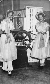 Eltham District Historical Society Inc
Photograph, Joy Chapman (left) with Dianne Bell in HMS Pinafore, 1960, 1960
My Recollections of Eltham Past by Margaret Joy Harding (nee Joy Chapman.) My family of Elizabeth and Alec Chapman moved to Eltham in 1946 into a cottage on the opposite side of the Diamond Creek from where the little train now operates in the Lower Park. At that time Eltham truly was a country town and the Pub was the main meeting place for most inhabitants on a Saturday afternoon in the beer garden. I attended Eltham Primary School where I started as a 4-year-old (my birthday being slightly after the mid-year intake) that happened then. My mother spent a lot of days taking me back to school when I had dismissed myself and walked the one kilomtre home alone. Bremner's Common (now Wingrove Park) was a big attraction with its dam and tad poling which I found much more entertaining than school. (Mrs Bremner ran a Service Station on the site of the current one). Another attraction at this site was the circus that came a couple of times a year. Watching them put up the circus tent was very interesting and even more of an attraction was the feeding of the Lions in cages and the monkeys and elephants among the other animals that are not found in a circus these days. At school then we were provided with hot chocolate at morning recess where the mothers would prepare it in the shelter shed. The only form of classroom heating was an open fire. Worse was the warm milk given in the summer months. By the time I was near finishing at Primary school we used to be able to walk along the Main Road at lunchtime to Mrs. Mitchell's shop to a delicious hot pie. As I recall there was no supervision for this departure from the school grounds. It is interesting that some of the other children I started school with I still have contact with, in fact one is a very good friend although now living in Perth. That is the other thing about Eltham; many who grew up here continue to live in the area. Following primary school, the natural progression was to Eltham High School. There was only the main building at that time and I can remember our first assembly at the front entrance. During the time I was at High School several new class rooms were added and the school hall. I remember the musical plays such as HMS Pinafore and other classical musicals being performed. I also remember countless hours doing marching practice. The main street shops when I was young consisted of the Blue Gum milk bar at the far end, a Grocery store and a shoe maker where Coles currently stands. Opposite there was Lyon's Garage. They also provided a bus service and when we got off the train this little bus would tour the back streets taking each individual to their home, sometimes this could take quite considerable time. There was also a Black Smith next to the Chiropractic Practice opposite Alistair Knox Park, another Milk Bar/General Store on the comer of Bridge Street/Main Road where a shop currently still operates. There was also a Butcher's shop down from the pub opposite Franklin Street. The only doctor was next to the courthouse on the other side of Brougham Street. On Saturday afternoon I was occasionally allowed to go the movies in the Town Hall which also stood on the site of the Coles centre. Often the Fire Alarm would sound and everyone would run outside to watch the fire truck leave with the volunteers clutching on the back. The other attraction during summer of course was the swimming pool which was a small concrete pool filled with water pumped from the Diamond Creek, sometimes it was like a mud puddle so for me the nearer to home Yarra/Diamond Creek junction was a much better option. We swam in the water hole which was quite deep and with fallen trees and sometimes carcasses of cows and kangaroos floating past. As recreation, the churches were another attraction for the Sunday school picnics to Mordialloc in the back of the moving van with benches tied into the back for us to "sit" on. Too bad when we went around a corner! In the early days we had an Ice Man deliver the ice once a week for "refrigeration". The green grocer came around in a horse and cart as did the milkman and the bread was delivered but I constantly got into trouble for eating the middle out on the way from the box it was delivered to in Mt Pleasant road across the paddock. The milkman finally would not come down our street after his horse bolted one morning and took off across the paddock. We also had the "Pan Man" come weekly and whose visit I would avoid. Our nearest shop was where the flower stall is located opposite the Lower Park. It consisted of a Tea Room and Milk Bar. There was a Public Telephone there which was the only contact to anyone else. We were a one car family so my mother’s movements were very limited as the Eltham Station was a couple of kilometres away and a trip to the city was an event. Being an only child growing up was a little lonely however rambling along the creek with my Mum, picking mushrooms and picking cherry plums for jam and the dogs catching rabbits which we ate if we could get them away from the dogs. We also liked to go into the Lower Park during school holidays when the Greek people came to camp and they would sing and dance around the camp fire and it all seemed so different to us as this was early days of immigration. Childhood was relatively simple and carefree and I wish the kids of today had the freedom of my youth and the healthy outdoor lifestyle of the "olden days". SHOW GIRL COMPETITION In 1965 Eltham was more like a country town than the suburb it has become today. People knew each other, if not personally then certainly of the family name. The big event for the year was a Gymkhana or show at Lower Eltham Park. I can remember marching as a teenager from the town centre to the park in the marching girls with the decorated floats. In 1965, just on a whim on the day, I decided to enter the Miss Eltham Show Girl which was a part of the festivities at the park. I seem to remember that the show mainly consisted of horse events, cattle judging and dog show. As I had not given any serious thought to entering the competition, I wore a suit that I had for work which was brown wool, with a coffee coloured shirt under, black shoes, bag, and gloves but no hat. I duly paraded for the judges and much to my surprise I was announced the winner. I eventually went on to compete at the Miss Victoria Show Girl competition which was held at the Royal Melbourne Show. There I met many country girls who were representing their rural Victoria home. I made it into a final round of judging but I think justice prevailed when someone from a country background was crowned. It was fun to go into the show as I had not really been before and to see the displays of handcraft, cooking and wood chopping events was great as well as the judging of farm animals interesting. It is hard to remember the Eltham I grew up in. The Lyons Garage company bus that actually drove you home (or close to it) when we got off the train at night. The Eltham Hotel on a Saturday afternoon a usual social meeting place where people just sat and chatted. The pictures held in the Town Hall and when the fire alarm sounded all the men just jumped up and ran to help. Suburbia has now swallowed most of that life but thankfully we at least do have the trestle bridge and parkland. Digital file only - Black and white photo print on loan for scanning by EDHSalec chapman, annie bremner, blacksmith, bremner's flat, brougham steet, bus services, circus, diamond creek, dianne bell, doctor bradbury, easter gymkhana, elizabeth chapman, eltham high school, eltham hotel, eltham lower park, eltham public hall, eltham state school, eltham trestle bridge, general store, grace mitchell, ice man, joy chapman, lyons garage, margaret harding, milk bar, miss eltham 1965, miss victoria show girl, mount pleasant road, pan man, rodda parade, shops, show girl competition, swimming pool, water hole, yarra river -
 Eltham District Historical Society Inc
Photograph, Rodda Parade looking towards the creek, 1960. Chapman home to the right, 1960
My Recollections of Eltham Past by Margaret Joy Harding (nee Joy Chapman.) My family of Elizabeth and Alec Chapman moved to Eltham in 1946 into a cottage on the opposite side of the Diamond Creek from where the little train now operates in the Lower Park. At that time Eltham truly was a country town and the Pub was the main meeting place for most inhabitants on a Saturday afternoon in the beer garden. I attended Eltham Primary School where I started as a 4-year-old (my birthday being slightly after the mid-year intake) that happened then. My mother spent a lot of days taking me back to school when I had dismissed myself and walked the one kilomtre home alone. Bremner's Common (now Wingrove Park) was a big attraction with its dam and tad poling which I found much more entertaining than school. (Mrs Bremner ran a Service Station on the site of the current one). Another attraction at this site was the circus that came a couple of times a year. Watching them put up the circus tent was very interesting and even more of an attraction was the feeding of the Lions in cages and the monkeys and elephants among the other animals that are not found in a circus these days. At school then we were provided with hot chocolate at morning recess where the mothers would prepare it in the shelter shed. The only form of classroom heating was an open fire. Worse was the warm milk given in the summer months. By the time I was near finishing at Primary school we used to be able to walk along the Main Road at lunchtime to Mrs. Mitchell's shop to a delicious hot pie. As I recall there was no supervision for this departure from the school grounds. It is interesting that some of the other children I started school with I still have contact with, in fact one is a very good friend although now living in Perth. That is the other thing about Eltham; many who grew up here continue to live in the area. Following primary school, the natural progression was to Eltham High School. There was only the main building at that time and I can remember our first assembly at the front entrance. During the time I was at High School several new class rooms were added and the school hall. I remember the musical plays such as HMS Pinafore and other classical musicals being performed. I also remember countless hours doing marching practice. The main street shops when I was young consisted of the Blue Gum milk bar at the far end, a Grocery store and a shoe maker where Coles currently stands. Opposite there was Lyon's Garage. They also provided a bus service and when we got off the train this little bus would tour the back streets taking each individual to their home, sometimes this could take quite considerable time. There was also a Black Smith next to the Chiropractic Practice opposite Alistair Knox Park, another Milk Bar/General Store on the comer of Bridge Street/Main Road where a shop currently still operates. There was also a Butcher's shop down from the pub opposite Franklin Street. The only doctor was next to the courthouse on the other side of Brougham Street. On Saturday afternoon I was occasionally allowed to go the movies in the Town Hall which also stood on the site of the Coles centre. Often the Fire Alarm would sound and everyone would run outside to watch the fire truck leave with the volunteers clutching on the back. The other attraction during summer of course was the swimming pool which was a small concrete pool filled with water pumped from the Diamond Creek, sometimes it was like a mud puddle so for me the nearer to home Yarra/Diamond Creek junction was a much better option. We swam in the water hole which was quite deep and with fallen trees and sometimes carcasses of cows and kangaroos floating past. As recreation, the churches were another attraction for the Sunday school picnics to Mordialloc in the back of the moving van with benches tied into the back for us to "sit" on. Too bad when we went around a corner! In the early days we had an Ice Man deliver the ice once a week for "refrigeration". The green grocer came around in a horse and cart as did the milkman and the bread was delivered but I constantly got into trouble for eating the middle out on the way from the box it was delivered to in Mt Pleasant road across the paddock. The milkman finally would not come down our street after his horse bolted one morning and took off across the paddock. We also had the "Pan Man" come weekly and whose visit I would avoid. Our nearest shop was where the flower stall is located opposite the Lower Park. It consisted of a Tea Room and Milk Bar. There was a Public Telephone there which was the only contact to anyone else. We were a one car family so my mother’s movements were very limited as the Eltham Station was a couple of kilometres away and a trip to the city was an event. Being an only child growing up was a little lonely however rambling along the creek with my Mum, picking mushrooms and picking cherry plums for jam and the dogs catching rabbits which we ate if we could get them away from the dogs. We also liked to go into the Lower Park during school holidays when the Greek people came to camp and they would sing and dance around the camp fire and it all seemed so different to us as this was early days of immigration. Childhood was relatively simple and carefree and I wish the kids of today had the freedom of my youth and the healthy outdoor lifestyle of the "olden days". SHOW GIRL COMPETITION In 1965 Eltham was more like a country town than the suburb it has become today. People knew each other, if not personally then certainly of the family name. The big event for the year was a Gymkhana or show at Lower Eltham Park. I can remember marching as a teenager from the town centre to the park in the marching girls with the decorated floats. In 1965, just on a whim on the day, I decided to enter the Miss Eltham Show Girl which was a part of the festivities at the park. I seem to remember that the show mainly consisted of horse events, cattle judging and dog show. As I had not given any serious thought to entering the competition, I wore a suit that I had for work which was brown wool, with a coffee coloured shirt under, black shoes, bag, and gloves but no hat. I duly paraded for the judges and much to my surprise I was announced the winner. I eventually went on to compete at the Miss Victoria Show Girl competition which was held at the Royal Melbourne Show. There I met many country girls who were representing their rural Victoria home. I made it into a final round of judging but I think justice prevailed when someone from a country background was crowned. It was fun to go into the show as I had not really been before and to see the displays of handcraft, cooking and wood chopping events was great as well as the judging of farm animals interesting. It is hard to remember the Eltham I grew up in. The Lyons Garage company bus that actually drove you home (or close to it) when we got off the train at night. The Eltham Hotel on a Saturday afternoon a usual social meeting place where people just sat and chatted. The pictures held in the Town Hall and when the fire alarm sounded all the men just jumped up and ran to help. Suburbia has now swallowed most of that life but thankfully we at least do have the trestle bridge and parkland. Digital file only - Black and white photo print on loan for scanning by EDHSalec chapman, annie bremner, blacksmith, bremner's flat, brougham steet, bus services, circus, diamond creek, dianne bell, doctor bradbury, easter gymkhana, elizabeth chapman, eltham high school, eltham hotel, eltham lower park, eltham public hall, eltham state school, eltham trestle bridge, general store, grace mitchell, ice man, joy chapman, lyons garage, margaret harding, milk bar, miss eltham 1965, miss victoria show girl, mount pleasant road, pan man, rodda parade, shops, show girl competition, swimming pool, water hole, yarra river -
 Eltham District Historical Society Inc
Photograph, Joy Chapman at the river junction, February 1962, Feb 1962
My Recollections of Eltham Past by Margaret Joy Harding (nee Joy Chapman.) My family of Elizabeth and Alec Chapman moved to Eltham in 1946 into a cottage on the opposite side of the Diamond Creek from where the little train now operates in the Lower Park. At that time Eltham truly was a country town and the Pub was the main meeting place for most inhabitants on a Saturday afternoon in the beer garden. I attended Eltham Primary School where I started as a 4-year-old (my birthday being slightly after the mid-year intake) that happened then. My mother spent a lot of days taking me back to school when I had dismissed myself and walked the one kilomtre home alone. Bremner's Common (now Wingrove Park) was a big attraction with its dam and tad poling which I found much more entertaining than school. (Mrs Bremner ran a Service Station on the site of the current one). Another attraction at this site was the circus that came a couple of times a year. Watching them put up the circus tent was very interesting and even more of an attraction was the feeding of the Lions in cages and the monkeys and elephants among the other animals that are not found in a circus these days. At school then we were provided with hot chocolate at morning recess where the mothers would prepare it in the shelter shed. The only form of classroom heating was an open fire. Worse was the warm milk given in the summer months. By the time I was near finishing at Primary school we used to be able to walk along the Main Road at lunchtime to Mrs. Mitchell's shop to a delicious hot pie. As I recall there was no supervision for this departure from the school grounds. It is interesting that some of the other children I started school with I still have contact with, in fact one is a very good friend although now living in Perth. That is the other thing about Eltham; many who grew up here continue to live in the area. Following primary school, the natural progression was to Eltham High School. There was only the main building at that time and I can remember our first assembly at the front entrance. During the time I was at High School several new class rooms were added and the school hall. I remember the musical plays such as HMS Pinafore and other classical musicals being performed. I also remember countless hours doing marching practice. The main street shops when I was young consisted of the Blue Gum milk bar at the far end, a Grocery store and a shoe maker where Coles currently stands. Opposite there was Lyon's Garage. They also provided a bus service and when we got off the train this little bus would tour the back streets taking each individual to their home, sometimes this could take quite considerable time. There was also a Black Smith next to the Chiropractic Practice opposite Alistair Knox Park, another Milk Bar/General Store on the comer of Bridge Street/Main Road where a shop currently still operates. There was also a Butcher's shop down from the pub opposite Franklin Street. The only doctor was next to the courthouse on the other side of Brougham Street. On Saturday afternoon I was occasionally allowed to go the movies in the Town Hall which also stood on the site of the Coles centre. Often the Fire Alarm would sound and everyone would run outside to watch the fire truck leave with the volunteers clutching on the back. The other attraction during summer of course was the swimming pool which was a small concrete pool filled with water pumped from the Diamond Creek, sometimes it was like a mud puddle so for me the nearer to home Yarra/Diamond Creek junction was a much better option. We swam in the water hole which was quite deep and with fallen trees and sometimes carcasses of cows and kangaroos floating past. As recreation, the churches were another attraction for the Sunday school picnics to Mordialloc in the back of the moving van with benches tied into the back for us to "sit" on. Too bad when we went around a corner! In the early days we had an Ice Man deliver the ice once a week for "refrigeration". The green grocer came around in a horse and cart as did the milkman and the bread was delivered but I constantly got into trouble for eating the middle out on the way from the box it was delivered to in Mt Pleasant road across the paddock. The milkman finally would not come down our street after his horse bolted one morning and took off across the paddock. We also had the "Pan Man" come weekly and whose visit I would avoid. Our nearest shop was where the flower stall is located opposite the Lower Park. It consisted of a Tea Room and Milk Bar. There was a Public Telephone there which was the only contact to anyone else. We were a one car family so my mother’s movements were very limited as the Eltham Station was a couple of kilometres away and a trip to the city was an event. Being an only child growing up was a little lonely however rambling along the creek with my Mum, picking mushrooms and picking cherry plums for jam and the dogs catching rabbits which we ate if we could get them away from the dogs. We also liked to go into the Lower Park during school holidays when the Greek people came to camp and they would sing and dance around the camp fire and it all seemed so different to us as this was early days of immigration. Childhood was relatively simple and carefree and I wish the kids of today had the freedom of my youth and the healthy outdoor lifestyle of the "olden days". SHOW GIRL COMPETITION In 1965 Eltham was more like a country town than the suburb it has become today. People knew each other, if not personally then certainly of the family name. The big event for the year was a Gymkhana or show at Lower Eltham Park. I can remember marching as a teenager from the town centre to the park in the marching girls with the decorated floats. In 1965, just on a whim on the day, I decided to enter the Miss Eltham Show Girl which was a part of the festivities at the park. I seem to remember that the show mainly consisted of horse events, cattle judging and dog show. As I had not given any serious thought to entering the competition, I wore a suit that I had for work which was brown wool, with a coffee coloured shirt under, black shoes, bag, and gloves but no hat. I duly paraded for the judges and much to my surprise I was announced the winner. I eventually went on to compete at the Miss Victoria Show Girl competition which was held at the Royal Melbourne Show. There I met many country girls who were representing their rural Victoria home. I made it into a final round of judging but I think justice prevailed when someone from a country background was crowned. It was fun to go into the show as I had not really been before and to see the displays of handcraft, cooking and wood chopping events was great as well as the judging of farm animals interesting. It is hard to remember the Eltham I grew up in. The Lyons Garage company bus that actually drove you home (or close to it) when we got off the train at night. The Eltham Hotel on a Saturday afternoon a usual social meeting place where people just sat and chatted. The pictures held in the Town Hall and when the fire alarm sounded all the men just jumped up and ran to help. Suburbia has now swallowed most of that life but thankfully we at least do have the trestle bridge and parkland. Digital file only - Black and white photo print on loan for scanning by EDHSalec chapman, annie bremner, blacksmith, bremner's flat, brougham steet, bus services, circus, diamond creek, dianne bell, doctor bradbury, easter gymkhana, elizabeth chapman, eltham high school, eltham hotel, eltham lower park, eltham public hall, eltham state school, eltham trestle bridge, general store, grace mitchell, ice man, joy chapman, lyons garage, margaret harding, milk bar, miss eltham 1965, miss victoria show girl, mount pleasant road, pan man, rodda parade, shops, show girl competition, swimming pool, water hole, yarra river -
 Eltham District Historical Society Inc
Photograph, Peter Pidgeon, Manna Gum, Main Road Bridge, Eltham South, 8 Sep. 2021
... and Diamond Creek Trail footbridge over the Diamond Creek at Eltham... and Diamond Creek Trail footbridge over the Diamond Creek at Eltham ...This significant tree located near the Main Road Bridge and Diamond Creek Trail footbridge over the Diamond Creek at Eltham dates back to the early 1900s. The original timber bridge over the Diamond Creek was built around 1840. It was destroyed by floodwaters in October 1923. A temporary bridge was rigged up but further damaged in April 1924. A new concrete bridge was built and opened in October 1926. The bridge decking was widened along with Main Road to Dalton Street by the Road Construction Authority in 1984., The uygraded bridge was opened in October 1984, 78 years after its original opening.These trees are not only significant for the natural environment but also present a navigational beacon back in time as the environmental landscape is developed around them.Born Digitaleltham south, main road bridge, manna gum, significant tree, diamond creek trail -
 Eltham District Historical Society Inc
Photograph, Peter Pidgeon, Manna Gums, Main Road Bridge, Eltham South, 8 Sep. 2021
... . eltham south main road bridge manna gum diamond creek trail Born ...The original timber bridge over the Diamond Creek was built around 1840. It was destroyed by floodwaters in October 1923. A temporary bridge was rigged up but further damaged in April 1924. A new concrete bridge was built and opened in October 1926. The bridge decking was widened along with Main Road to Dalton Street by the Road Construction Authority in 1984., The uygraded bridge was opened in October 1984, 78 years after its original opening.These trees are not only significant for the natural environment but also present a navigational beacon back in time as the environmental landscape is developed around them.Born Digitaleltham south, main road bridge, manna gum, diamond creek trail