Showing 9591 items matching "east street"
-
 Eltham District Historical Society Inc
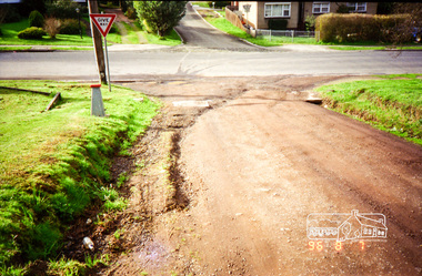
Photograph, Road surface conditions around Eltham: Looking east along John Street at the intersection with Bible Street, 7 Aug 1996, 1996
... Road surface conditions around Eltham: Looking east along... conditions around Eltham: Looking east along John Street ...Shows sections of Franklin, John and Napoleon streets were still unmade as of late 1996 and the condition of those roads with potholes at the intersections with Bible Street.Reflects on the changing nature of the local street-scape and housesRoll of 35mm colour negative film, 7 stripsKodak Gold 100-5eltham, napoleon street, bible street, franklin street, john street -
 Eltham District Historical Society Inc
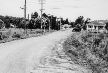
Photograph, Looking east along Diamond Street to the railway crossing near intersection with Main Road, Eltham, February 1968, Feb 1968
... Looking east along Diamond Street to the railway crossing... took a series of photos from the Eltham Hotel at Pitt Street ...Shows houses on Main Road and Cecil Street across Main Road from Diamond Street.In February 1968 an unknown person took a series of photos from the Eltham Hotel at Pitt Street heading north along Main Road through the shopping centre to just north of Elsa Court covering the length of the section of Main Road which was duplicated shortly thereafter. Shows the condition and environment of the streesscape of Main Road, Eltham immediately prior to the duplication between Pitt Street and Elsa Court through the shopping centre. Also shows a number of shops and businesses that operated at that time.Black and white photographduplication, eltham, main road, diamond street, railway line, railway crossing, cecil street, judge book village -
 Eltham District Historical Society Inc
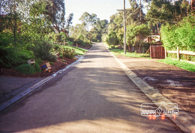
Photograph, Road surface conditions around Eltham: Looking east along Franklin Street adjacent to No. 131, 7 Aug 1996, 1996
... Road surface conditions around Eltham: Looking east along... conditions around Eltham: Looking east along Franklin Street adjacent ...Shows sections of Franklin, John and Napoleon streets were still unmade as of late 1996 and the condition of those roads with potholes at the intersections with Bible Street.Reflects on the changing nature of the local street-scape and housesRoll of 35mm colour negative film, 7 stripsKodak Gold 100-5eltham, napoleon street, bible street, franklin street, john street -
 Eltham District Historical Society Inc
Photograph, Brougham Street Eltham looking east to Susan Street
... Brougham Street Eltham looking east to Susan Street... of Brougham Street factory area Brougham Street Eltham looking east ...Colour photograph of Brougham Street factory areabrougham street, eltham, susan street -
 Eltham District Historical Society Inc
Photograph, Margaret Ball, Looking east up Arthur Street from Main Road, Eltham, c.June 1999, 1999
... Looking east up Arthur Street from Main Road, Eltham... in Eltham between Main Road and east to Bible Street, between Cecil ...The Margaret Ball (Pre 1960s Houses) Collection was a personal project initiated to mark the year 2000 and arose as a result of the disappearance of many pre-1960s parts of Eltham due to development. Approximately 200 pre-1960s style houses that were left in Eltham between Main Road and east to Bible Street, between Cecil Street to the north and south to Dalton Street were photographed in late 1999. Not all of the houses could be photographed; some because the garden or trees blocked the view of the house, others because of rubbish or cars were in the way, some because people were working on the house or in the gardens at the time.Colour photographic print eltham, houses, streets, margaret ball (pre 1960s houses) collection, arthur street -
 Ringwood and District Historical Society
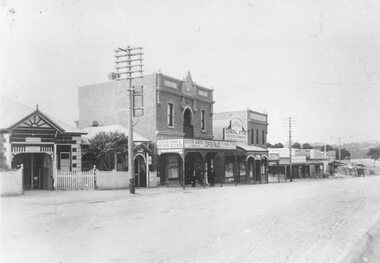
Photograph, Maroondah Highway Central, Ringwood. Looking east towards Adelaide Street and Warrandyte Road, 1918
... Maroondah Highway Central, Ringwood. Looking east towards... Central, Ringwood. Looking east towards Adelaide Street ...Black and white photograph (3 copies- 2 large, 1 small).Typed below one large photograph: "Maroondah Hwy. 1918. Taken from outside railway station looking towards Warrandyte Rd." Image shows Coffee Palace and general store in middle, and Ringwood Post Office to the left. -
 Ringwood and District Historical Society
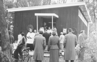
Photograph, Church of England, Patterson Street, East Ringwood, Vic. - circa 1960
... Church of England, Patterson Street, East Ringwood, Vic... of England, Patterson Street, East Ringwood, Vic. - circa 1960 ...Church of England Church at East Ringwood with people leavingWritten on back of photograph, "E. Rwd." Church of England Church at East Ringwood -
 Ringwood and District Historical Society
Photographs, Holy Trinity Church, Paterson Street, East Ringwood in 1999
... Holy Trinity Church, Paterson Street, East Ringwood in 1999... Street, East Ringwood in 1999 Photographs ... -
 Ringwood and District Historical Society
Photograph, View from Loughnan Rd. looking south east over Harrison Street/Andrew Street corner, c.1949
... View from Loughnan Rd. looking south east over Harrison... from Loughnan Rd. looking south east, 1949". Written on backing ...Black and white photograph showing some vacant land and new houses under construction. Developed area in background. (3 copies)Typed below photograph, "View from Loughnan Rd. looking south east, 1949". Written on backing sheet, "View from Loughnan Rd. to corner Harrison and Andrew Street, c1949". -
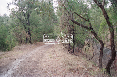
 Eltham District Historical Society Inc
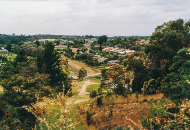
Photograph, Metropolitan Water pipe track east from Afton Street, Research, 19 December 1992, 19/12/1992
... Metropolitan Water pipe track east from Afton Street... east from Afton Street, Research, 19 December 1992 Photograph ...The Eltham Horse Trail: Research and Warrandyte to Kinglake: Survey of proposed route, December 1992: (4) Connecting trail to ElthamColour photographeltham horse trail (1992 survey), afton street, research (vic.) -
 Eltham District Historical Society Inc
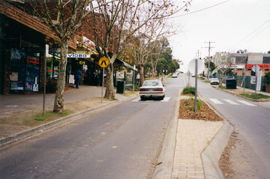
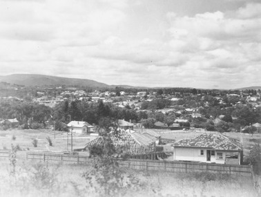
Photograph, Main Road, Eltham looking east towards Bolton Street (south), c.May 2001
... Main Road, Eltham looking east towards Bolton Street (south)... looking east towards Bolton Street (south) Photograph Photograph ...Roll of 35mm colour negative film, 7 stripsAgfa HDC 200 plus-2eltham, streets, main road, bolton street -
 Eltham District Historical Society Inc
Photograph, Fred Mitchell, Looking east along Arthur Street just down from intersection with Bible Street, Eltham, 1968, 1968
... Looking east along Arthur Street just down from... streets Digital copy of colour photograph Looking east along ...Valiant is parked outside what was no. 43 now part of a unit complex at no. 41. Immediately in front of Valiant is no. 45, which has been a vacant block since before 1990. Gentleman in hat with paper walking up hill is outside no. 39, now a unit complex and the old house on left is no. 37 (since replaced) which borders what is now the Walter Withers ReserveDigital copy of colour photographfred mitchell collection, 1968, bible street, arthur street, eltham, houses, streets -
 Rutherglen Historical Society
Image, Main Street, East Rutherglen, 1909
... Main Street, East Rutherglen.... Main Street, East Rutherglen Image ...Coloured postcard showing Main Street, Rutherglen with the Victoria Hotel in the foreground.main street, victoria hotel -
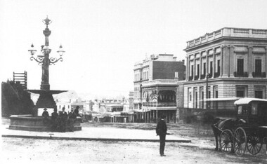
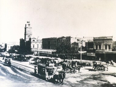 City of Ballarat Libraries
Photograph - Card Box Photographs, View east along Sturt Street from Doveton Street South, Ballarat 1878
... View east along Sturt Street from Doveton Street South... Streetscape Commerical Public View east along Sturt Street from ...The photo shows horse drawn trams and cabs, the Ballarat Town Hall, Theatre Royal and Iles Luncheon Rooms. There are also shades over the garden seats. sturt street, doveton street south, ballarat town hall, theatre royal, iles luncheon rooms, streetscape, commerical, public -
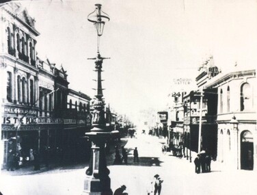 City of Ballarat Libraries
Photograph - Card Box Photographs, View east along Bridge Street, Ballarat circa 1890
... View east along Bridge Street, Ballarat circa 1890.... Ballarat East goldfields Along the street are Cocking & Skewes ...Along the street are Cocking & Skewes, the Bucks Head Hotel and C. Morris, Hatter.bridge street, cocking & skewes, bucks head hotel, c.morris, streetscape, street lamp, commerical, building, vehicle -
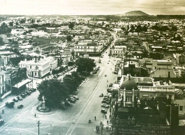 City of Ballarat Libraries
Photograph - Card Box Photographs, View east along Sturt Street, Ballarat circa 1939
... View east along Sturt Street, Ballarat circa 1939....City of Ballarat Libraries Eureka Centre Eureka Street ...The photo was taken from the Town Hall tower. The dome of the National Mutual building is clearly visible.sturt street, town hall, streetscape, national mutual building, commerical, public, vehicle, garden -
 City of Ballarat Libraries
Photograph - Card Box Photographs, View east along Sturt Street, Ballarat circa 1905. From the Star 1855-1905 Jubilee publication
... View east along Sturt Street, Ballarat circa 1905. From... Ballarat East goldfields Sturt Street Streetscape Commerical ...sturt street, streetscape, commerical, vehicle, garden, public -
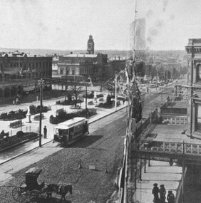
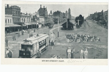
 City of Ballarat Libraries
Photograph - Card Box Photographs, Burke & Wills Monument and view south east along Sturt Street, Ballarat 1880
... Burke & Wills Monument and view south east along Sturt... Monument and view south east along Sturt Street, Ballarat 1880 ...Also seen in the photograph are the electric telegraph, London Chartered Bank, Unicorn Hotel and the Mechanics' Institute.burke & wills monument, sturt street, buildings, monument, commerical, hotel, public, vehicle, persons -
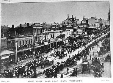 City of Ballarat Libraries
Postcard - Card Box Photographs, Sturt Street East, Eight Hours' Procession
... Sturt Street East, Eight Hours' Procession.... Ballarat East goldfields Plate 13. Black Photo. Sturt Street Eight ...Plate 13. Black Photo.sturt street, eight hours' procession, celebrations, vehicles, persons -
 Ballarat Tramway Museum
Drawing - Illustration/s, Sturt Street East - photoshopped
... Sturt Street East - photoshopped... held. Sturt Street East - photoshopped Drawing Illustration/s ...Yields information about the ESCo electric trams and the streetscape the Grenville St era and demonstrates how items were "photoshopped" or manipulated into the photo to make the street look busy.Photo montage of ESCo tram No 16, before windscreens (No 16) at Grenville St looking towards Town Hall. Four motor cars, and pedestrians have been added to the original photo to make the street "Look busy". On the reverse is a photo cropped at the top of Eureka Monument. The photo has buildings on the south side of Sturt St. in the view. Image re-scanned at high density 14-9-2013 and record checked. Two copies held.trams, tramways, sturt st, grenville st, ballarat trams, esco -
![High Street, East Kew [looking west], 1977](/media/collectors/550653872162f11fb04854aa/items/586f8bbfd0ce0e07f06d22ed/item-media/586f8c3ad0ce0e07f06d44cc/item-fit-380x285.jpg) Kew Historical Society Inc
Kew Historical Society IncPhotograph, High Street, East Kew, 1977
... High Street, East Kew..., October 1977. High Street, East Kew Photograph Photograph ...The Kew Historical Society's Pictures Collection is comprised of photographs and original works of art. The photographs include original (mainly) images dating from the 1870s to the present. A number of these photographs derive from the former City of Kew's Civic Collection while others are the work of amateur and professional photographers. Most of the images in the collection depict people, places and objects within the suburbs of Kew and Kew East. Other photographs depict other locations in Melbourne and Victoria. A number of the photographs are of statewide and/or national significance.View from junction of High and Strathalbyn Sts., Kew East, looking approximately west toward Cemetery, October 1977. Inscription reverse: "KH-72. View from junction of High St. & Strathalbyn Sts, Kew E. Looking approx. west, towards Cemetery. October 1977."high street -- kew (vic.), streetscapes -- kew (vic.) -
 Ringwood and District Historical Society
Photograph, Edwin G. Adamson A.R.P.S, Maroondah Highway Central, Ringwood. Looking east from Ringwood Street 1963. (Eastland Litigation Photo), May 1963
... Maroondah Highway Central, Ringwood. Looking east from... Maroondah Highway Central, Ringwood. Looking east from Ringwood ...This series of SS0380 photos are part of the "Eastland Litigation" launched in 1962 by the Whitehorse Traders Co-operative Association (WTCA), against the Ringwood Council's Interim Development Order of 1960. WTCA sought "orders from the Supreme Court of Victoria that the planning scheme was invalid" - See "The Eastland Litigation" chapter in "From Horse Shoes to High Heels - Ringwood Shopping Centre and Eastland 1858-2008" by Richard Carter, Bounce Books 2009.Black and white photographWritten on back of photograph: "Photo showing cars parked and travelling along M'dah Hway" Stamped on back of photograph, 'Edwin G. Adamson...May 63'. -
 Eltham District Historical Society Inc
Negative - Photograph, Maroondah Aqueduct Trail east of Afton Street, Research, 1991
... Maroondah Aqueduct Trail east of Afton Street, Research... east of Afton Street, Research Negative Photograph ...Roll of 35mm colour negative film, 9 strips Colour print 10 x 15 cmFuji HG 200 CA-1afton street, maroondah aqueduct, maroondah aqueduct trail, research (vic.) -
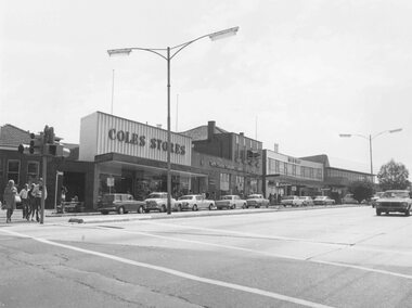 Ringwood and District Historical Society
Photograph, Maroondah Highway Central, Ringwood. Shops in Maroondah Highway looking east from Ringwood Street. c1974
... Highway looking east from Ringwood Street. c1974.... Highway looking east from Ringwood Street. c1974. Photograph ...Black and white photographImage shows shops on north side of the road including Coles Stores, State Savings Bank, and Midway Arcade. -
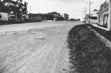 Ringwood and District Historical Society
Photograph, Maroondah Highway West, Ringwood- c1920's. Looking east towards Ringwood Street
... Maroondah Highway West, Ringwood- c1920's. Looking east...- c1920's. Looking east towards Ringwood Street. Photograph ...Black and white photograph -
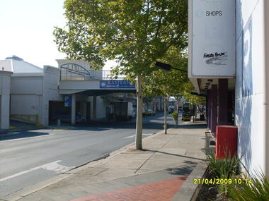
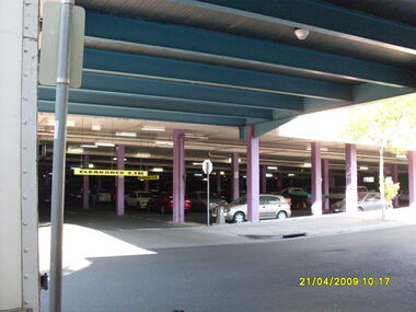 Ringwood and District Historical Society
Photograph, Carpark under Eastland looking east from Ringwood Street. Ringwood on 21 April 2009
... Carpark under Eastland looking east from Ringwood Street... Eastland looking east from Ringwood Street. Ringwood on 21 April ...Ron Brons photographic study of Ringwood. -
 Ringwood and District Historical Society
Photograph, Driveway through Eastland looking east. Joining Ringwood Street and former Adelaide Street. Ringwood on 21 April 2009
... Driveway through Eastland looking east. Joining Ringwood... Eastland looking east. Joining Ringwood Street and former Adelaide ...Ron Brons photographic study of Ringwood. -
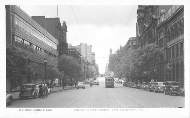 Melbourne Tram Museum
Postcard, Rose Stereograph Co, "Collins Street looking east, Melbourne", late 1940s
... "Collins Street looking east, Melbourne"...Rose Series postcard No. P 2618, titled "Collins Street... Series postcard No. P 2618, titled "Collins Street looking east ...Rose Series postcard No. P 2618, titled "Collins Street looking east, Melbourne", Photo shows W2 class tram 543 about to arrive at its Collins and Spencer Streets destination. The return destination has been reset to Kew route 42. Another W2 is in the far distance. The McPherson’s Pty Ltd. building on the left was built 1934-37. Photo late 1940sYields information about the west end of Collins St late 1940s.Postcard - printed real photograph with Rose Stereograph Co. name on the rear.tramways, trams, collins st, w2 class, tram 543, route 42 -
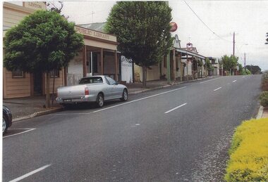 Linton and District Historical Society Inc
Photograph, East Side of Sussex Street, Linton, 2014
... East Side of Sussex Street, Linton, 2014... to the south along the east side of Sussex Street. The former public... Hunt in 2014. East Side of Sussex Street, Linton, 2014 ...One of three colour photographs which have been printed on a single sheet of photographic paper. The photograph shows the view to the south along the east side of Sussex Street. The former public library building, the Historical Society building (formerly Nelson Bros Undertakers), the Railway Hotel, the former CFA building and other shops and houses can be seen on the left of the photograph, which was taken by Gary Hunt in 2014.linton public library building, linton & district historical society resource centre building, railway hotel linton, cfa building linton, sussex street linton -
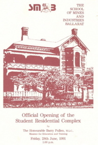 Federation University Historical Collection
Document - Invitiation, Invitiation and Programme for the opening of the Ballarat School of Mines Complex at 130 Victoria Street, Ballarat East, 1991, 28/06/1991
... School of Mines Complex at 130 Victoria Street, Ballarat East... images and text. Each photo shows an image of 130 Victoria Street...130 Webster Street, Ballarat East... shows an image of 130 Victoria Street, Ballarat East. .1 & .2 ...The opening of the Complex on 28 June 1991 marks a significant step in the capacity of the Ballarat School of Mines to provide quality, modern, purpose built and comfortable accommodation for student. Funding for the project came primarily from the sale of Ballarat School of Mines hostels owned by the Education Department in Webster Street which allowed the construction and refurbishment at 128-130 Webster Street to became an impressive complex.An invitation and programme on cream card with marron images and text. Each photo shows an image of 130 Victoria Street, Ballarat East. .1 & .2) Programme for the Official Opening of the Ballarat School of Mines Student Residential Complex at 130 Victoria Street by the Honourable Barry Pullen, M.L.C., minister for Education and training, on 28 June 1991. .3 7 .4) Invitation to attend the official opening of the Ballarat School of Mines Student Residential Complex at 130 Victoria Streetballarat school of mines student residential complex, ballarat school of mines, 130 victoria st, hostel, student residence, barry pullen, barker, jack barker, e.j. barker, terry moran, anne fennell