Showing 704 items matching "economic"
-
 Kew Historical Society Inc
Plan - Subdivision Plan, Tregarron Estate, Kew, c.1929
Pru Sanderson, in her groundbreaking ‘City of Kew Urban Conservation Study : Volume 2 - Development History’ (1988), summarised the periods of urban development and subdivisions of land in Kew. The periods that she identified included 1845-1880, 1880-1893, 1893-1921, 1921-1933, 1933-1943, and Post-War Development. These periods were selected as they represented periods of rapid growth or decline in urban development. An obvious starting point for Sanderson’s groupings involved population growth and the associated economic cycles. These cycles also highlighted urban expansion onto land that was predominantly rural, although in other cases it represented the decline and breakup of large estates. A number of the plans in the Kew Historical Society’s collection can also be found in other collections, such as those of the State Library of Victoria and the Boroondara Library Service. A number are however unique to the collection.Subdivision plans are historically important documents used as evidence of the growth of suburbs in Australia. They frequently provide information about when the land was sold on which a built structure was subsequently constructed as well as evidence relating to surveyors and real estate and financial agents. The numerous subdivision plans in the Kew Historical Society's collection represent working documents, ranging from the initial sketches made in planning a subdivision to printed plans on which auctioneers or agents listed the prices for which individual lots were sold. In a number of cases, the reverse of a subdivision plan in the collection includes a photograph of a house that was also for sale by the agent. These photographs provide significant heritage information relating house design and decoration, fencing and household gardens.In January 1929, the Kew City Council called for tenders to construct Tregarron Avenue. The subdivision of the Tregarron Estate in Kew was for 11 lots bordering Tregarron Avenue and its entrance from Burke Road. The plan includes annotations that indicate the measurement of each block and the placement of the drainage and sewerage easements. This plan is interesting for a number of factors. The house blocks today have different street numbers, some blocks were to be further subdivided, and at the time of the subdivision, alterations were still being made to the extent of lots offered; lots 2 and 3 on the plan were subdivided and reoriented.subdivision plans - kew, tregarron estate, tregarron avenue -- kew (vic.), burke road -- kew (vic.) -
 Kew Historical Society Inc
Plan - Subdivision Plan, Kewdene Estate, 1937-1939
Pru Sanderson, in her groundbreaking ‘City of Kew Urban Conservation Study : Volume 2 - Development History’ (1988), summarised the periods of urban development and subdivisions of land in Kew. The periods that she identified included 1845-1880, 1880-1893, 1893-1921, 1921-1933, 1933-1943, and Post-War Development. These periods were selected as they represented periods of rapid growth or decline in urban development. An obvious starting point for Sanderson’s groupings involved population growth and the associated economic cycles. These cycles also highlighted urban expansion onto land that was predominantly rural, although in other cases it represented the decline and breakup of large estates. A number of the plans in the Kew Historical Society’s collection can also be found in other collections, such as those of the State Library of Victoria and the Boroondara Library Service. A number are however unique to the collection.The Kew Historical Society collection includes almost 100 subdivision plans pertaining to suburbs of the City of Melbourne. Most of these are of Kew, Kew East or Studley Park, although a smaller number are plans of Camberwell, Deepdene, Balwyn and Hawthorn. It is believed that the majority of the plans were gifted to the Society by persons connected with the real estate firm - J. R. Mathers & McMillan, 136 Cotham Road, Kew. The Plans in the collection are rarely in pristine form, being working plans on which the agent would write notes and record lots sold and the prices of these. The subdivision plans are historically significant examples of the growth of urban Melbourne from the beginning of the 20th Century up until the 1980s. A number of the plans are double-sided and often include a photograph on the reverse. The advertisement for the ‘Kewdene Estate’ subdivision is pasted over a photograph of a property for sale. This is typical of the reuse of promotional materials in the period during, and subsequent to World War I. The subdivision included 14 lots bordered by Belmore Road, Birtles Street and Giles Street. On the other side of the subdivision [Glass] Creek is noted. The subdivision plan also shows part of the Outer Circle Railway and Deepdene Railway Station.subdivision plans - east kew, kewdene estate, belmore road -- kew east (vic.), giles street -- kew east (vic.) -
 Kew Historical Society Inc
Plan - Subdivision Plan, Boulevard Estate - Boulevard Section, 1930-1936
Pru Sanderson, in her groundbreaking ‘City of Kew Urban Conservation Study : Volume 2 - Development History’ (1988), summarised the periods of urban development and subdivisions of land in Kew. The periods that she identified included 1845-1880, 1880-1893, 1893-1921, 1921-1933, 1933-1943, and Post-War Development. These periods were selected as they represented periods of rapid growth or decline in urban development. An obvious starting point for Sanderson’s groupings involved population growth and the associated economic cycles. These cycles also highlighted urban expansion onto land that was predominantly rural, although in other cases it represented the decline and breakup of large estates. A number of the plans in the Kew Historical Society’s collection can also be found in other collections, such as those of the State Library of Victoria and the Boroondara Library Service. A number are however unique to the collection.The Kew Historical Society collection includes almost 100 subdivision plans pertaining to suburbs of the City of Melbourne. Most of these are of Kew, Kew East or Studley Park, although a smaller number are plans of Camberwell, Deepdene, Balwyn and Hawthorn. It is believed that the majority of the plans were gifted to the Society by persons connected with the real estate firm - J. R. Mathers and McMillan, 136 Cotham Road, Kew. The Plans in the collection are rarely in pristine form, being working plans on which the agent would write notes and record lots sold and the prices of these. The subdivision plans are historically significant examples of the growth of urban Melbourne from the beginning of the 20th Century up until the 1980s. A number of the plans are double-sided and often include a photograph on the reverse. This plan shows a subdivision with two sections: the ‘Boulevard Section’ and the ‘Riverside Section’. The first of these sections bordered Burke Road between Kilby Road and the farm beside the Yarra. Kilby Road, Munro Road, Burke Road and Old Burke Road bordered the 102 lots in the Boulevard Section of the plan. The streets within the Section included Walbundry Avenue, Inverness Way, Riverside Avenue, Cascade Street and Kyora Parade. These street names, at least in this subdivision plan linked the two Sections of the subdivision. At a later date, the City of Kew decided to alter the street names. Walbundry, Inverness, Riverside, Cascade and Kyora were all renamed as ‘Drives’ (e.g. Kyora Drive). The subdivision plan is of interest in that it names High Street in Kew as Doncaster Road. It also shows the location of the wooden church that was later removed to Yarraville on the corner of Kilby Road and High Street. The plan predates later developments such as the S. E. Dickens Supermarket.subdivision plans - east kew, boulevard estate, munro road -- kew east (vic.), kilby road -- kew east (vic.), burke road -- kew east (vic.), walbundry avenue -- kew east (vic.), inverness way -- kew east (vic.), riverside avenue -- kew east (vic.), cascade drive -- kew east (vic.), nyora parade -- kew east (vic.) -
 Kew Historical Society Inc
Plan - Subdivision Plan, Goldthorns Hill Estate, 1925
Pru Sanderson, in her groundbreaking ‘City of Kew Urban Conservation Study : Volume 2 - Development History’ (1988), summarised the periods of urban development and subdivisions of land in Kew. The periods that she identified included 1845-1880, 1880-1893, 1893-1921, 1921-1933, 1933-1943, and Post-War Development. These periods were selected as they represented periods of rapid growth or decline in urban development. An obvious starting point for Sanderson’s groupings involved population growth and the associated economic cycles. These cycles also highlighted urban expansion onto land that was predominantly rural, although in other cases it represented the decline and breakup of large estates. A number of the plans in the Kew Historical Society’s collection can also be found in other collections, such as those of the State Library of Victoria and the Boroondara Library Service. A number are however unique to the collection.The Kew Historical Society collection includes almost 100 subdivision plans pertaining to suburbs of the City of Melbourne. Most of these are of Kew, Kew East or Studley Park, although a smaller number are plans of Camberwell, Deepdene, Balwyn and Hawthorn. It is believed that the majority of the plans were gifted to the Society by persons connected with the real estate firm - J. R. Mathers and McMillan, 136 Cotham Road, Kew. The Plans in the collection are rarely in pristine form, being working plans on which the agent would write notes and record lots sold and the prices of these. The subdivision plans are historically significant examples of the growth of urban Melbourne from the beginning of the 20th Century up until the 1980s. A number of the plans are double-sided and often include a photograph on the reverse. The Goldthorns Hill Estate subdivision was first put up for auction in 1925. The subdivision took its name from the mansion ‘Goldthorns’, shown on the plan between Normanby Road and Lady Loch’s Drive. Contemporary advertisements describe forty-three home sites being fro sale, yet only forty-one appear on this plan. Buyers were lured by the prospect of the proposed extension of the Burke Road tram to High Street. Discerning buyers were advised that only one house could be built per allotment, and that houses needed to be constructed of brick, stone or concrete and have a slate or tiled roof.goldthorns avenue -- kew east (vic.), lady loch drive -- kew east (vic.), argyle road -- kew east (vic.), lady brassey drive -- kew east (vic.), campbell street -- kew east (vic.), goldthorns -- kew (vic.), subdivisions -- kew east (viv.), goldthorns hill estate -
 Kew Historical Society Inc
Map - Subdivision Plan, Grenville Estate, 1922
Pru Sanderson, in her groundbreaking ‘City of Kew Urban Conservation Study : Volume 2 - Development History’ (1988), summarised the periods of urban development and subdivisions of land in Kew. The periods that she identified included 1845-1880, 1880-1893, 1893-1921, 1921-1933, 1933-1943, and Post-War Development. These periods were selected as they represented periods of rapid growth or decline in urban development. An obvious starting point for Sanderson’s groupings involved population growth and the associated economic cycles. These cycles also highlighted urban expansion onto land that was predominantly rural, although in other cases it represented the decline and breakup of large estates. A number of the plans in the Kew Historical Society’s collection can also be found in other collections, such as those of the State Library of Victoria and the Boroondara Library Service. A number are however unique to the collection.Subdivision plans are historically important documents used as evidence of the growth of suburbs in Australia. They frequently provide information about when the land was sold on which a built structure was subsequently constructed as well as evidence relating to surveyors and real estate and financial agents. The numerous subdivision plans in the Kew Historical Society's collection represent working documents, ranging from the initial sketches made in planning a subdivision to printed plans on which auctioneers or agents listed the prices for which individual lots were sold. In a number of cases, the reverse of a subdivision plan in the collection includes a photograph of a house that was also for sale by the agent. These photographs provide significant heritage information relating house design and decoration, fencing and household gardens.In advertising the twenty-two sites of the Grenville Estate in Cotham Road and Alfred Street, Kew, the auctioneers emphasised the proximity of the development to shops, schools, and churches. That mansions surrounded the Estate was publicised as an added attraction. The plan shows how at this stage A regrettable aspect of this plan is that it is pasted over, and obscures a real estate photograph by the Kew photographer Josiah Earl Barnes.subdivision plans - kew, grenville estate, glenferrie road, alfred street, thomas street, cotham road -
 Kew Historical Society Inc
Plan - Subdivision Plan, Forres Estate, East Kew, 1919, 1919
Pru Sanderson, in her groundbreaking ‘City of Kew Urban Conservation Study : Volume 2 - Development History’ (1988), summarised the periods of urban development and subdivisions of land in Kew. The periods that she identified included 1845-1880, 1880-1893, 1893-1921, 1921-1933, 1933-1943, and Post-War Development. These periods were selected as they represented periods of rapid growth or decline in urban development. An obvious starting point for Sanderson’s groupings involved population growth and the associated economic cycles. These cycles also highlighted urban expansion onto land that was predominantly rural, although in other cases it represented the decline and breakup of large estates. A number of the plans in the Kew Historical Society’s collection can also be found in other collections, such as those of the State Library of Victoria and the Boroondara Library Service. A number are however unique to the collection.Subdivision plans are historically important documents used as evidence of the growth of suburbs in Australia. They frequently provide information about when the land was sold on which a built structure was subsequently constructed as well as evidence relating to surveyors and real estate and financial agents. The numerous subdivision plans in the Kew Historical Society's collection represent working documents, ranging from the initial sketches made in planning a subdivision to printed plans on which auctioneers or agents listed the prices for which individual lots were sold. In a number of cases, the reverse of a subdivision plan in the collection includes a photograph of a house that was also for sale by the agent. These photographs provide significant heritage information relating house design and decoration, fencing and household gardens.An annotated subdivision plan for the Forres Estate, Kew East. The estate was advertised in 1919, the Melbourne Auctioneers being represented locally by Henry Kellett, Estate Agent of High Street, Kew. The name of the estate was derived from the mansion (demolished 2016) of the same name in Normanby Road, which was at one stage owned by the Mayor of Kew, Cr. J. S. Were.subdivision plans - kew, forres estate, argyle road, simpson street, hubert street, normanby road -
 Kew Historical Society Inc
Plan - Subdivision Plan, St Helliers Estate, Kew, circa 1910, c.1910
Pru Sanderson, in her groundbreaking ‘City of Kew Urban Conservation Study : Volume 2 - Development History’ (1988), summarised the periods of urban development and subdivisions of land in Kew. The periods that she identified included 1845-1880, 1880-1893, 1893-1921, 1921-1933, 1933-1943, and Post-War Development. These periods were selected as they represented periods of rapid growth or decline in urban development. An obvious starting point for Sanderson’s groupings involved population growth and the associated economic cycles. These cycles also highlighted urban expansion onto land that was predominantly rural, although in other cases it represented the decline and breakup of large estates. A number of the plans in the Kew Historical Society’s collection can also be found in other collections, such as those of the State Library of Victoria and the Boroondara Library Service. A number are however unique to the collection.Subdivision plans are historically important documents used as evidence of the growth of suburbs in Australia. They frequently provide information about when the land was sold on which a built structure was subsequently constructed as well as evidence relating to surveyors and real estate and financial agents. The numerous subdivision plans in the Kew Historical Society's collection represent working documents, ranging from the initial sketches made in planning a subdivision to printed plans on which auctioneers or agents listed the prices for which individual lots were sold. In a number of cases, the reverse of a subdivision plan in the collection includes a photograph of a house that was also for sale by the agent. These photographs provide significant heritage information relating house design and decoration, fencing and household gardens.In the subdivision of part of Crown Portion 82, bordered by John and Sackville Streets and Cotham and Burke Roads, over 100 lots were offered for sale. In addition to the designated lots, a number of key locations are also identified. These include the Genazzano Convent to the north of Cotham Road, the Reservoir, St Hilary’s and the land holding of Colonel Parnell on the corner of John Street and Cotham Road. On the Plan, No. 5064, is the handwritten name ‘St. Hellier’s Estate’. St. Helliers, the home of the Dumaresq family is shown beside St. Hilary’s.subdivision plans - kew, st helliers estate -
 Kew Historical Society Inc
Plan - Subdivision Plan, Rimington Nursery Estate, 1949
Pru Sanderson, in her groundbreaking ‘City of Kew Urban Conservation Study : Volume 2 - Development History’ (1988), summarised the periods of urban development and subdivisions of land in Kew. The periods that she identified included 1845-1880, 1880-1893, 1893-1921, 1921-1933, 1933-1943, and Post-War Development. These periods were selected as they represented periods of rapid growth or decline in urban development. An obvious starting point for Sanderson’s groupings involved population growth and the associated economic cycles. These cycles also highlighted urban expansion onto land that was predominantly rural, although in other cases it represented the decline and breakup of large estates. A number of the plans in the Kew Historical Society’s collection can also be found in other collections, such as those of the State Library of Victoria and the Boroondara Library Service. A number are however unique to the collection.The Kew Historical Society collection includes almost 100 subdivision plans pertaining to suburbs of the City of Melbourne. Most of these are of Kew, Kew East or Studley Park, although a smaller number are plans of Camberwell, Deepdene, Balwyn and Hawthorn. It is believed that the majority of the plans were gifted to the Society by persons connected with the real estate firm - J. R. Mathers and McMillan, 136 Cotham Road, Kew. The Plans in the collection are rarely in pristine form, being working plans on which the agent would write notes and record lots sold and the prices of these. The subdivision plans are historically significant examples of the growth of urban Melbourne from the beginning of the 20th Century up until the 1980s. A number of the plans are double-sided and often include a photograph on the reverse. A number of the latter are by noted photographers such as J.E. Barnes.The house lots in the Rimington Nursery Estate were advertised for sale on Saturday 22nd October 1949. The nine lots in the sale were in Stoke Avenue and Burke Road. Mathers & McMillan of 136 Cotham Road, Kew, offered the lots for sale. [The final sale of lots within the Rimington Nursery Estate occurred as late as 1958.]subdivision plans - kew, rimington nursery estate, monist victor road - kew (vic.) -
 Kew Historical Society Inc
Plan - Subdivision Plan, Erin Heights Estate, East kew, 1917
Pru Sanderson, in her groundbreaking ‘City of Kew Urban Conservation Study : Volume 2 - Development History’ (1988), summarised the periods of urban development and subdivisions of land in Kew. The periods that she identified included 1845-1880, 1880-1893, 1893-1921, 1921-1933, 1933-1943, and Post-War Development. These periods were selected as they represented periods of rapid growth or decline in urban development. An obvious starting point for Sanderson’s groupings involved population growth and the associated economic cycles. These cycles also highlighted urban expansion onto land that was predominantly rural, although in other cases it represented the decline and breakup of large estates. A number of the plans in the Kew Historical Society’s collection can also be found in other collections, such as those of the State Library of Victoria and the Boroondara Library Service. A number are however unique to the collection.The Kew Historical Society collection includes almost 100 subdivision plans pertaining to suburbs of the City of Melbourne. Most of these are of Kew, Kew East or Studley Park, although a smaller number are plans of Camberwell, Deepdene, Balwyn and Hawthorn. It is believed that the majority of the plans were gifted to the Society by persons connected with the real estate firm - J. R. Mathers and McMillan, 136 Cotham Road, Kew. The Plans in the collection are rarely in pristine form, being working plans on which the agent would write notes and record lots sold and the prices of these. The subdivision plans are historically significant examples of the growth of urban Melbourne from the beginning of the 20th Century up until the 1980s. A number of the plans are double-sided and often include a photograph on the reverse. A number of the latter are by noted photographers such as J.E. Barnes.The Erin Heights Estate in Kew included just seven lots in in Valerie Street. These were all that remained of this wartime subdivision, the other 11 allotments on Balfour and Belford Roads having already been sold. Balfour Road was to be only a temporary name as the street is currently called Windella Avenue. Now, the parkland opposite the subdivision is the reserve created from the route of the Outer Circle Railway. This Railway reached Kew East in 1925, but had been planned as far back as 1873. The development focuses on the benefits of living in Kew: being at the highest of Kew’s ‘suburbs’; being a good residential area; its rapid growth; and the proximity of the Kew East tram in High Street. In 1917, the electric tramline only extended to a terminus at the Harp of Erin hotel. The terminus is clearly represented on the plan.subdivision plans - east kew, erin heights estate -
 Kew Historical Society Inc
Plan - Subdivision Plan, J R Mathers & McMillan, Willsmere Park Estate, c.1940
Pru Sanderson, in her groundbreaking ‘City of Kew Urban Conservation Study : Volume 2 - Development History’ (1988), summarised the periods of urban development and subdivisions of land in Kew. The periods that she identified included 1845-1880, 1880-1893, 1893-1921, 1921-1933, 1933-1943, and Post-War Development. These periods were selected as they represented periods of rapid growth or decline in urban development. An obvious starting point for Sanderson’s groupings involved population growth and the associated economic cycles. These cycles also highlighted urban expansion onto land that was predominantly rural, although in other cases it represented the decline and breakup of large estates. A number of the plans in the Kew Historical Society’s collection can also be found in other collections, such as those of the State Library of Victoria and the Boroondara Library Service. A number are however unique to the collection.The Kew Historical Society collection includes almost 100 subdivision plans pertaining to suburbs of the City of Melbourne. Most of these are of Kew, Kew East or Studley Park, although a smaller number are plans of Camberwell, Deepdene, Balwyn and Hawthorn. It is believed that the majority of the plans were gifted to the Society by persons connected with the real estate firm - J. R. Mathers and McMillan, 136 Cotham Road, Kew. The Plans in the collection are rarely in pristine form, being working plans on which the agent would write notes and record lots sold and the prices of these. The subdivision plans are historically significant examples of the growth of urban Melbourne from the beginning of the 20th Century up until the 1980s. A number of the plans are double-sided and often include a photograph on the reverse. A number of the latter are by noted photographers such as J.E. Barnes. In 1910, the Willsmere Park Estate Dairy was lauded in the Box Hill Reporter as ‘an object lesson in dairying’. Ten years later, in 1923, it was to be sold. The first subdivision of the Estate included 77 grand allotments with frontages to Belford and Kilby Roads, Elm and Willow Groves, and Acacia Avenue. Every lot was claimed to be ‘high and dry’, and with panoramic views of Kew and East Kew. The balance of the Estate, and the largest proportion of allotments was to be subdivided and sold from 1940. This second sale included 109 lots fronting Kilby Road and Elm and Willow Groves. Annotations on the plan indicate that the more expensive lots faced Belford Road opposite the Kew Golf Links. Two of these sold for £310. Lots further to the west in Willow Grove were sold for £60 less. Many of the houses to be built on these 109 allotments after the War faced Government restrictions on building materials and the dimensions of each house due to postwar shortages.subdivision plans - east kew, willsmere park estate -
 Kew Historical Society Inc
Plan - Subdivision Plan, Jas R Mathers Son & McMillan, East Kew Tramway Estate, 1915
Pru Sanderson, in her groundbreaking ‘City of Kew Urban Conservation Study : Volume 2 - Development History’ (1988), summarised the periods of urban development and subdivisions of land in Kew. The periods that she identified included 1845-1880, 1880-1893, 1893-1921, 1921-1933, 1933-1943, and Post-War Development. These periods were selected as they represented periods of rapid growth or decline in urban development. An obvious starting point for Sanderson’s groupings involved population growth and the associated economic cycles. These cycles also highlighted urban expansion onto land that was predominantly rural, although in other cases it represented the decline and breakup of large estates. A number of the plans in the Kew Historical Society’s collection can also be found in other collections, such as those of the State Library of Victoria and the Boroondara Library Service. A number are however unique to the collection.The Kew Historical Society collection includes almost 100 subdivision plans pertaining to suburbs of the City of Melbourne. Most of these are of Kew, Kew East or Studley Park, although a smaller number are plans of Camberwell, Deepdene, Balwyn and Hawthorn. It is believed that the majority of the plans were gifted to the Society by persons connected with the real estate firm - J. R. Mathers and McMillan, 136 Cotham Road, Kew. The Plans in the collection are rarely in pristine form, being working plans on which the agent would write notes and record lots sold and the prices of these. The subdivision plans are historically significant examples of the growth of urban Melbourne from the beginning of the 20th Century up until the 1980s. A number of the plans are double-sided and often include a photograph on the reverse. A number of the latter are by noted photographers such as J.E. Barnes.The East Kew Tramway Estate was a subdivision of two separate parcels of land between Adeney Avenue and Normanby Road. The larger section included 54 lots facing Adeney Avenue, Argyle Road, and Campbell, Hunter and Wishart Streets. [Hunter and Wishart Streets were created as part of the subdivision.] A further 17 allotments faced Normanby Road, Hubert and Campbell Streets. [The name of Hubert Street was later to be changed to Cecil Street.] The promotion of the sale referred to the advantages of living between two tram routes, in High Street and Cotham Road. On the plan, quaintly drawn trams mark these routes. Also on the plan is the route of part of the Outer Circle [Railway] Line.east kew tramway estate, subdivision plans - east kew -
 Kew Historical Society Inc
Plan - Subdivision Plan, J R Mathers & McMillan, Clutha Subdivision, 1940
Pru Sanderson, in her groundbreaking ‘City of Kew Urban Conservation Study : Volume 2 - Development History’ (1988), summarised the periods of urban development and subdivisions of land in Kew. The periods that she identified included 1845-1880, 1880-1893, 1893-1921, 1921-1933, 1933-1943, and Post-War Development. These periods were selected as they represented periods of rapid growth or decline in urban development. An obvious starting point for Sanderson’s groupings involved population growth and the associated economic cycles. These cycles also highlighted urban expansion onto land that was predominantly rural, although in other cases it represented the decline and breakup of large estates. A number of the plans in the Kew Historical Society’s collection can also be found in other collections, such as those of the State Library of Victoria and the Boroondara Library Service. A number are however unique to the collection.The Kew Historical Society collection includes almost 100 subdivision plans pertaining to suburbs of the City of Melbourne. Most of these are of Kew, Kew East or Studley Park, although a smaller number are plans of Camberwell, Deepdene, Balwyn and Hawthorn. It is believed that the majority of the plans were gifted to the Society by persons connected with the real estate firm - J. R. Mathers and McMillan, 136 Cotham Road, Kew. The Plans in the collection are rarely in pristine form, being working plans on which the agent would write notes and record lots sold and the prices of these. The subdivision plans are historically significant examples of the growth of urban Melbourne from the beginning of the 20th Century up until the 1980s. A number of the plans are double-sided and often include a photograph on the reverse. A number of the latter are by noted photographers such as J.E. Barnes.The subdivision plan for the Clutha Subdivision is one of the largest in the Society’s collection. The plan includes a map of the proposed allotments, photographic views to the north and south, and information about the kinds of buildings that could be constructed on the allotments. The subdivision was bounded by Studley Park Road, and Carson, Stevenson and Edgecombe Streets. Two new streets, Mackie Court and Younger Street were created as part of the subdivision. The subdivision took its name from ‘Clutha’, the home of John Carson, who was to become Mayor of Kew in 1863. A Report to the City of Boroondara outlined how: ‘The Clutha estate was progressively developed from 1940, with new houses under construction on the Studley Park Road, Carson and Edgecombe Street frontages by 1941. By 1943, directory listings were available for all addresses with the exception of Mackie Court. Building ceased after the government’s prohibition on civilian building was enforced from 1942, with little change in listings until the 1950s when the remainder of the subdivision was developed’."H"subdivisions - kew - studley park, clutha subdivision, studley park road -
 Kew Historical Society Inc
Plan - Subdivision Plan, Jas R Mathers Son & McMillan, Macartney Estate, East Kew, c. 1925
Pru Sanderson, in her groundbreaking ‘City of Kew Urban Conservation Study : Volume 2 - Development History’ (1988), summarised the periods of urban development and subdivisions of land in Kew. The periods that she identified included 1845-1880, 1880-1893, 1893-1921, 1921-1933, 1933-1943, and Post-War Development. These periods were selected as they represented periods of rapid growth or decline in urban development. An obvious starting point for Sanderson’s groupings involved population growth and the associated economic cycles. These cycles also highlighted urban expansion onto land that was predominantly rural, although in other cases it represented the decline and breakup of large estates. A number of the plans in the Kew Historical Society’s collection can also be found in other collections, such as those of the State Library of Victoria and the Boroondara Library Service. A number are however unique to the collection.Subdivision plans are historically important documents used as evidence of the growth of suburbs in Australia. They frequently provide information about when the land was sold on which a built structure was subsequently constructed as well as evidence relating to surveyors and real estate and financial agents. The numerous subdivision plans in the Kew Historical Society's collection represent working documents, ranging from the initial sketches made in planning a subdivision to printed plans on which auctioneers or agents listed the prices for which individual lots were sold. In a number of cases, the reverse of a subdivision plan in the collection includes a photograph of a house that was also for sale by the agent. These photographs provide significant heritage information relating house design and decoration, fencing and household gardens.The Macartney Estate subdivision advertised 21 lots for sale on either side of Macartney Street (now Macartney Avenue) and Evans Road in what was then designated as East Kew. Most of the houses shown on the south side of Macartney Street then, as now, have rear entrances on Mount Street, however a number of these blocks have since been further subdivided to allow for the building of new houses on the rear of a block. Brougham Place is marked on the plan but is now called Daniell Place."C"subdivision plans - east kew, macartney estate, macartney street, mount street, evans road, brougham place -
 Kew Historical Society Inc
Plan - Subdivision Plan, J R Mathers & McMillan, Glenarbor Estate, 1934
Pru Sanderson, in her groundbreaking ‘City of Kew Urban Conservation Study : Volume 2 - Development History’ (1988), summarised the periods of urban development and subdivisions of land in Kew. The periods that she identified included 1845-1880, 1880-1893, 1893-1921, 1921-1933, 1933-1943, and Post-War Development. These periods were selected as they represented periods of rapid growth or decline in urban development. An obvious starting point for Sanderson’s groupings involved population growth and the associated economic cycles. These cycles also highlighted urban expansion onto land that was predominantly rural, although in other cases it represented the decline and breakup of large estates. A number of the plans in the Kew Historical Society’s collection can also be found in other collections, such as those of the State Library of Victoria and the Boroondara Library Service. A number are however unique to the collection.The Kew Historical Society collection includes almost 100 subdivision plans pertaining to suburbs of the City of Melbourne. Most of these are of Kew, Kew East or Studley Park, although a smaller number are plans of Camberwell, Deepdene, Balwyn and Hawthorn. It is believed that the majority of the plans were gifted to the Society by persons connected with the real estate firm - J. R. Mathers and McMillan, 136 Cotham Road, Kew. The Plans in the collection are rarely in pristine form, being working plans on which the agent would write notes and record lots sold and the prices of these. The subdivision plans are historically significant examples of the growth of urban Melbourne from the beginning of the 20th Century up until the 1980s. A number of the plans are double-sided and often include a photograph on the reverse. A number of the latter are by noted photographers such as J.E. Barnes.The little-known Glenarbor Estate comprised 23 allotments bordering Wellington and Denmark Streets and Fenton Avenue. The auction of the allotments in the Estate was held in the Kew Recreation Hall. The purported advantages to Kew are identified on the plan, such as the close proximity of the entrance to the Kew Railway Station and access to shops in Denmark Street. Due to its location, the subdivision was pitched at commercial as well as residential purchasers. The Estate was to cause a crisis in the Kew Council as a majority of councillors voted on 29 May to acquire the entire Estate as the location of a new Town Hall. The Estate was said to be valued at £50,000. A later meeting was to rescind the vote, instead opting for the compulsory acquisition of South Esk on the corner of Charles Street and Cotham Road. That acquisition was to be overturned by the State Government. The debate about the purchase of the Glenarbor Estate by Council coincided with the decision to widen High Street on the South side between Cotham Road and the Junction."D"subdivision plans - kew, glenarbor estate, wellington street, denmark street -
 Kew Historical Society Inc
Plan - Subdivision Plan, Jas R Mathers Son & McMillan, The Dale Estate, Deepdene, 1918
Pru Sanderson, in her groundbreaking ‘City of Kew Urban Conservation Study : Volume 2 - Development History’ (1988), summarised the periods of urban development and subdivisions of land in Kew. The periods that she identified included 1845-1880, 1880-1893, 1893-1921, 1921-1933, 1933-1943, and Post-War Development. These periods were selected as they represented periods of rapid growth or decline in urban development. An obvious starting point for Sanderson’s groupings involved population growth and the associated economic cycles. These cycles also highlighted urban expansion onto land that was predominantly rural, although in other cases it represented the decline and breakup of large estates. A number of the plans in the Kew Historical Society’s collection can also be found in other collections, such as those of the State Library of Victoria and the Boroondara Library Service. A number are however unique to the collection.The Kew Historical Society collection includes almost 100 subdivision plans pertaining to suburbs of the City of Melbourne. Most of these are of Kew, Kew East or Studley Park, although a smaller number are plans of Camberwell, Deepdene, Balwyn and Hawthorn. It is believed that the majority of the plans were gifted to the Society by persons connected with the real estate firm - J. R. Mathers and McMillan, 136 Cotham Road, Kew. The Plans in the collection are rarely in pristine form, being working plans on which the agent would write notes and record lots sold and the prices of these. The subdivision plans are historically significant examples of the growth of urban Melbourne from the beginning of the 20th Century up until the 1980s. A number of the plans are double-sided and often include a photograph on the reverse. A number of the latter are by noted photographers such as J.E. Barnes.The Dale Estate in Deepdene was made possible by the death of Robert Sparrow Smythe, Australian journalist, newspaper editor/owner and theatrical manager. Smythe lived in his residence ‘Highate’, Deepdene until his death in 1917. In the subdivision proposed one year later, before the end of the First World War, 18 allotments were to be created. The very fragmentary plan in the Society’s collection notes that a large weatherboard [house] will need to be removed. This may be Smythe’s own home. The proposed subdivision included allotments facing Burke and Whitehorse Roads and Dale Street. Bordering the subdivision is the Deepdene Station and the Outer Circle Railway Line. The clear directions on the plan indicate that in 1918 it was possible to travel by train from Deepdene to East Camberwell and Ashburtonsubdivision plans - deepdene, the dale estate -
 Kew Historical Society Inc
Plan - Subdivision Plan, Jas R Mathers Son & McMillan, Clifton Estate, Kew, c. 1916
Pru Sanderson, in her groundbreaking ‘City of Kew Urban Conservation Study : Volume 2 - Development History’ (1988), summarised the periods of urban development and subdivisions of land in Kew. The periods that she identified included 1845-1880, 1880-1893, 1893-1921, 1921-1933, 1933-1943, and Post-War Development. These periods were selected as they represented periods of rapid growth or decline in urban development. An obvious starting point for Sanderson’s groupings involved population growth and the associated economic cycles. These cycles also highlighted urban expansion onto land that was predominantly rural, although in other cases it represented the decline and breakup of large estates. A number of the plans in the Kew Historical Society’s collection can also be found in other collections, such as those of the State Library of Victoria and the Boroondara Library Service. A number are however unique to the collection.The Kew Historical Society collection includes almost 100 subdivision plans pertaining to suburbs of the City of Melbourne. Most of these are of Kew, Kew East or Studley Park, although a smaller number are plans of Camberwell, Deepdene, Balwyn and Hawthorn. It is believed that the majority of the plans were gifted to the Society by persons connected with the real estate firm - J. R. Mathers and McMillan, 136 Cotham Road, Kew. The Plans in the collection are rarely in pristine form, being working plans on which the agent would write notes and record lots sold and the prices of these. The subdivision plans are historically significant examples of the growth of urban Melbourne from the beginning of the 20th Century up until the 1980s. A number of the plans are double-sided and often include a photograph on the reverse. A number of the latter are by noted photographers such as J.E. Barnes.The Clifton Estate was an ambitious subdivision. It included 61 allotments bordering Cotham and Park Hill Roads, and Florence and Adeney Avenues. It is difficult to ascertain the exact year when the ‘Clifton Estate’ was surveyed, subdivided and first auctioned. The uncertainty may be due to allotments being released during the First World War. The subdivision took its name from the house ‘Clifton’ (lot 5) on the corner of Adeney Avenue and Cotham Road. The outline of Clifton (since demolished) and the extent of its land following the subdivision are represented on the plan. The auctioneers have also shown ‘Maryfield’ and ‘Wimba’, the neighbouring properties in Cotham Road, on the plan."B"subdivision plans - kew, clifton estate, cotham road, adeney avenue, florence avenue, park hill road -
 Kew Historical Society Inc
Plan - Subdivision Plan, Plan of Subdivision of Part of Crown Portion 84 / Parish of Boroondara / County of Bourke / Lodged Plan No. 2217, Twentieth Century
Pru Sanderson, in her groundbreaking ‘City of Kew Urban Conservation Study : Volume 2 - Development History’ (1988), summarised the periods of urban development and subdivisions of land in Kew. The periods that she identified included 1845-1880, 1880-1893, 1893-1921, 1921-1933, 1933-1943, and Post-War Development. These periods were selected as they represented periods of rapid growth or decline in urban development. An obvious starting point for Sanderson’s groupings involved population growth and the associated economic cycles. These cycles also highlighted urban expansion onto land that was predominantly rural, although in other cases it represented the decline and breakup of large estates. A number of the plans in the Kew Historical Society’s collection can also be found in other collections, such as those of the State Library of Victoria and the Boroondara Library Service. A number are however unique to the collection.The Kew Historical Society collection includes almost 100 subdivision plans pertaining to suburbs of the City of Melbourne. Most of these are of Kew, Kew East or Studley Park, although a smaller number are plans of Camberwell, Deepdene, Balwyn and Hawthorn. It is believed that the majority of the plans were gifted to the Society by persons connected with the real estate firm - J. R. Mathers and McMillan, 136 Cotham Road, Kew. The Plans in the collection are rarely in pristine form, being working plans on which the agent would write notes and record lots sold and the prices of these. The subdivision plans are historically significant examples of the growth of urban Melbourne from the beginning of the 20th Century up until the 1980s. A number of the plans are double-sided and often include a photograph on the reverse. A number of the latter are by noted photographers such as J.E. Barnes.Undated Plan of Subdivision of Crown Portion 84 in what is now Kew. The area shown is bordered by Burke Road, Harp Road, Arglye Road and Normanby Road.subdivision plans -- kew (vic), harp road, burke road, normanby road, lady loch's drive, gladstone street, second avenue, first avenue -
 City of Greater Bendigo - Civic Collection
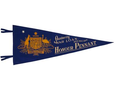
Award - Set of Twenty Two Security Loan Honour Pennants, Commonwealth of Australia, c 1946 - 1963
Australia, like many countries involved in both the First and Second World Wars realised that they would need more funds to resource their campaigns, so war loan programs were developed. These programs encouraged the population to purchase government war bonds which would be repaid with interest at a later time while immediately assisting the war effort. Post WW2 the government continued to encourage citizens to save money in an attempt to curb inflation. Security loans formed part of this countries economic program from the 1940's onwards. Districts were allocated a quota for which they encouraged citizens to subscribe and pennants were awarded for the highest per capita payment amongst the town population. In 1946 Bendigo was the first country city in Australia to record a quota success for the Second Security Loan, raising £260,480 from 1953 subscribers. Triangle felt screen printed pennants, various colours with two ties along left side. Pennants range in date from 1942 until 1963. 253.1 Blue felt triangle pennant with two ties on long side. Gold printed Commonwealth of Australia Coat of Arms, cream printed text and one star top left of crest. Dimensions: 1010mm W x 355 H x 3mm 253.2 Blue felt triangle pennant with two ties on long side. Gold printed Commonwealth of Australia Coat of Arms, printed cream, red and blue coloured text . One cream coloured printed star top left of crest. Dimensions: 985 W x 367 H x 3mm 253.3 Blue felt triangle pennant with two ties on long side. Gold printed Commonwealth of Australia Coat of Arms, printed cream, red and blue coloured text . One cream coloured printed star top left of crest. Dimensions: 955W x 355 H x 3mm 253.4 Green felt triangle pennant with two ties on long side. Gold printed Commonwealth of Australia Coat of Arms, printed cream, red and green coloured text . One cream coloured printed star top left of crest. Dimensions: 970 W x 367 H x 3mm 253.5 Green felt triangle pennant with two ties on long side. Gold printed Commonwealth of Australia Coat of Arms, printed yellow, pink and green coloured text . Two cream coloured printed stars top left of crest. Dimensions: 975 W x 370 H x 3mm 253.6 Red felt triangle pennant with two ties on long side and remnants of bronze ribbon stapled to long side. Yellow printed Commonwealth of Australia Coat of Arms, printed white, yellow, cream and light blue text . Two cream coloured printed stars top left of crest. One light blue star centre right. Dimensions: 1055 W x 355 H x 3mm 253.7 Light blue felt triangle pennant with two ties on long side and bronze ribbon stapled to long side. Yellow printed Commonwealth of Australia Coat of Arms, printed red, white and dark blue text . One cream coloured printed star top left of crest. Dimensions: 966 W x 355 H x 3mm 253.8 Green felt triangle pennant with two ties on long side. Yellow printed Commonwealth of Australia Coat of Arms, printed pink, white and yellow text . One cream coloured printed star top left of crest. Dimensions: 970 W x 350 H x 3mm 253.9 Red felt triangle pennant with two ties on long side and remnants of bronze ribbon stapled to long side. Yellow, blue, red and cream printed Commonwealth of Australia Coat of Arms with printed black, white and light blue text. Additional text on long side of pennant adjacent to ties. Three cream coloured printed stars top left of crest. Dimensions: 965 W x 350 H x 3mm 253.10 Blue felt triangle pennant with two ties on long side and remnants of bronze ribbon attached to ties. Yellow printed Commonwealth of Australia Coat of Arms with printed dark blue, cream and red text. Two cream coloured printed stars top left of crest. Dimensions: 930 W x 365 H x 3mm 253.11 Red felt triangle pennant with two ties on long side. Yellow, blue, red and cream printed Commonwealth of Australia Coat of Arms with light blue and cream text. Three cream coloured printed stars top left of crest. Dimensions: 1025 W x 355H x 2mm 253.12 Dark blue felt triangle pennant with two ties on long side. Yellow printed Commonwealth of Australia Coat of Arms with light blue text. Additional text on long side of pennant adjacent to ties. One cream coloured printed star top left of crest. Dimensions: 920 W x 338 H x 3mm 253.13 Dark blue felt triangle pennant with two ties on long side. Yellow printed Commonwealth of Australia Coat of Arms with maroon text. One cream coloured printed star top left of crest. Dimensions: 930 W x 360 H x 3mm 253.14 Dark blue felt triangle pennant with two ties on long side. Yellow printed Commonwealth of Australia Coat of Arms with yellow text. Two cream coloured printed stars top left of crest. Dimensions 910 W x 345 H x 3mm 253.15 Dark blue felt triangle pennant with two ties on long side. Yellow printed Commonwealth of Australia Coat of Arms with light blue text. one cream coloured printed star top left of crest. Dimensions: 905 W x 345 H x 3mm. 253.16 Dark blue felt triangle pennant with two ties on long side. Yellow printed Commonwealth of Australia Coat of Arms with brown text. One cream coloured printed star top left of crest. Dimensions: 930 W x 360 H x 3mm 253.17 Dark blue felt triangle pennant with two ties on long side. Yellow printed Commonwealth of Australia Coat of Arms with blue text. One cream coloured printed star top left of crest. Dimensions: 915 W x 350 H x 3mm 253.18 Dark blue felt triangle pennant with two ties on long side. Yellow printed Commonwealth of Australia Coat of Arms with blue text. One cream coloured printed star top left of crest. Dimensions: 950 W x 355 H x 3mm 253.19 Dark blue felt triangle pennant with two ties on long side. Yellow printed Commonwealth of Australia Coat of Arms with blue text. One cream coloured printed star top left of crest. Dimensions: 950 W x 355 H x 3mm 253.20 Dark blue felt triangle pennant with two ties on long side. Yellow printed Commonwealth of Australia Coat of Arms with cream text. One cream coloured printed star top left of crest. Dimensions: 965 W x 360 H x 3mm 253.21 Dark blue felt triangle pennant with two ties on long side. Yellow printed Commonwealth of Australia Coat of Arms with blue text. One cream coloured printed star top left of crest. Dimensions: 950 W x 365 H x 3mm 253.22 Dark blue felt triangle pennant with two ties on long side. Yellow printed Commonwealth of Australia Coat of Arms with cream text. One cream coloured printed star top left of crest. Dimensions: 940 W x 365 H x 3mm 253.1 Austerity /War Loan / Nov - Dec 1942 / Honour Pennant 253.2 Second / Security Loan / Oct - Nov 1946 / Honour Pennant 253.3 Third / Security Loan / April - May 1947 / Honour Pennant 253.4 Fourth / Security Loan / Oct - Nov 1947 / Honour Pennant 253.5 Fifth / Security Loan / April - May 1948 / Honour Pennant 253.6 Seventh/ Security Loan / March – April 1949 / Bendigo 253.7 Eighth / Security Loan / Sept – Oct 1949 / Honour Pennant 253.8 Ninth / Security Loan / March 1950 / Honour Pennant 253.9 Special Award / Tenth / Security Loan / August 1950 / City of Bendigo 253.10 Eleventh/ Security Loan / Nov-Dec 1950 / Honour Pennant 253.11 Special Award / 12th Security Loan / may- June 1951 / City of Bendigo 253.12 Sixteenth / Security Loan / Nov-Dec 1952 / Honour Pennant 253.13 Eighteenth / Security Loan / Sept – Oct 1953 / Honour Pennant 253.14 Nineteenth / Security Loan / March 1954 / Honour Pennant 253.15 Commonwealth / Security Loan / August 1954 / Honour Pennant 253.16 Commonwealth / Security Loan / august 1954 / Honour Pennant 253.17 Commonwealth / Security Loan / August 1956 / Honour Pennant 253.18 Commonwealth / Security Loan / August 1957 / Honour Pennant 253.19 Commonwealth / Security Loan / May 1960/ Honour Pennant 253.20 Commonwealth / Security Loan / September 1960/ Honour Pennant 253.21 Commonwealth / Security Loan / February March 1961/ Honour Pennant 253.22 Commonwealth / Security Loan / February 1963 / Honour Pennant commonwealth loan scheme, city of greater bendigo awards -
 Bendigo Historical Society Inc.
Document - DEBORAH REEF PROJECT ENVIRONMENT EFFECTS STATEMENT
Two page document. On top, first page ' Bendigo Mining N.L., Deborah Reef Project, Environment Effects Statement, Summary Brochure'. Poppet head on top LH corner of document. A map of central Bendigo is drawn on page 1 and shows the location of the proposed processing plant near the Airport. Further maps on page 2 and 3 show the North Deborah Mine Site, the pipeline route and the airfield site. The summary brochure provides an outline of the material contained in the Environment Effects Statement and proposed planning scheme amendments upon which, the Deborah Reef Project will be assessed. Page four lists the issues that impact on this submission: planning and land use; socio economic environment; traffic; discharges to air; water management; explosives storage and handling; subsidence; heritage; flora and fauna and landscape and visual assessment. The 16th March, 1989, is the date given for submissions to be lodged in regard to this project.Bendigo Mining N.Lbendigo, mining, deborah reef project -
 Victorian Aboriginal Corporation for Languages
Book, Marguerita Stephens, The journal of William Thomas : assistant protector of the Aborigines of Port Phillip &? guardian of the Aborigines of Victoria 1839 - 1867 : volume one : 1839 to 1843, 2014
This series presents 28 years of Thomas' journals, transcribed and annotated by Dr Marguerita Stephens (Vols 1-3). Vol 4 provides a substantial collection of Thomas' records of Kulin language - some reworked from earlier transcriptions by Dr Stephen Morey. For nearly three decades William Thomas chronicled his life and work with Aboriginal Victorians through his daily journal entries. Now this four volume set, comprehensively indexed and extensively annotated, shines new light on the history of race relations in Australia. Thomas' detailed observations give a rare insight into the process of cultural continuity and collapse, and the agency of Victorian Aboriginal leaders in social and economic interactions with settlers and colonial administrations in a time of great social upheaval. This first-hand account repopulates Victorian history, paying respect to the work, play and lives of the Aboriginal men and women who emerge from the pages of Thomas' journal.document reproductions, b&w illustrationswurundjeri, woiwurrung, woi wurrung, yarra, waverong, wavarong, waborong, warwarong, warworong, waworong, wa woo rong, wouvarong, wavorong, port phillip, boon wurrung, mount macedon, bacchus marsh, backhouse marsh, boonurrong, boonurong, boonmerong, bonwarong, boomerong, boonvarong, boonerong, bunurong, boonrong, boonworng, boonurong, boonwrung, boonurgs, taungurung, goulbourn, tongorong, devils river tribe, wathaurong, wadawurrung, barrabool, barabool, wattowrong, william thomas, geelong, ballarat, mount buninyong, booningong, leigh river tribe, dja dja wurrung, avoca, loddon river, bangerang, pangerang, pangeran, pangarran, pangarans, parngarangs, ovens river tribe, broken river tribe, gunai kurnai, omeo, monaro -
 Victorian Aboriginal Corporation for Languages
Book, Marguerita Stephens, The journal of William Thomas : assistant protector of the Aborigines of Port Phillip &? guardian of the Aborigines of Victoria 1839 - 1867 : volume two: 1844 to 1853, 2014
This series presents 28 years of Thomas' journals, transcribed and annotated by Dr Marguerita Stephens (Vols 1-3). Vol 4 provides a substantial collection of Thomas' records of Kulin language - some reworked from earlier transcriptions by Dr Stephen Morey. For nearly three decades William Thomas chronicled his life and work with Aboriginal Victorians through his daily journal entries. Now this four volume set, comprehensively indexed and extensively annotated, shines new light on the history of race relations in Australia. Thomas' detailed observations give a rare insight into the process of cultural continuity and collapse, and the agency of Victorian Aboriginal leaders in social and economic interactions with settlers and colonial administrations in a time of great social upheaval. This first-hand account repopulates Victorian history, paying respect to the work, play and lives of the Aboriginal men and women who emerge from the pages of Thomas' journal.document reproductionswurundjeri, woiwurrung, woi wurrung, yarra, waverong, wavarong, waborong, warwarong, warworong, waworong, wa woo rong, wouvarong, wavorong, port phillip, boon wurrung, mount macedon, bacchus marsh, backhouse marsh, boonurrong, boonurong, boonmerong, bonwarong, boomerong, boonvarong, boonerong, bunurong, boonrong, boonworng, boonurong, boonwrung, boonurgs, taungurung, goulbourn, tongorong, devils river tribe, wathaurong, wadawurrung, barrabool, barabool, wattowrong, william thomas, geelong, ballarat, mount buninyong, booningong, leigh river tribe, dja dja wurrung, avoca, loddon river, bangerang, pangerang, pangeran, pangarran, pangarans, parngarangs, ovens river tribe, broken river tribe, gunai kurnai, omeo, monaro -
 Victorian Aboriginal Corporation for Languages
Book, Marguerita Stephens, The journal of William Thomas : assistant protector of the Aborigines of Port Phillip &? guardian of the Aborigines of Victoria 1839 - 1867 : volume three: 1854 to 1867, 2014
Annotation. This series presents 28 years of Thomas' journals, transcribed and annotated by Dr Marguerita Stephens (Vols 1-3). Vol 4 provides a substantial collection of Thomas' records of Kulin language - some reworked from earlier transcriptions by Dr Stephen Morey. For nearly three decades William Thomas chronicled his life and work with Aboriginal Victorians through his daily journal entries. Now this four volume set, comprehensively indexed and extensively annotated, shines new light on the history of race relations in Australia. Thomas' detailed observations give a rare insight into the process of cultural continuity and collapse, and the agency of Victorian Aboriginal leaders in social and economic interactions with settlers and colonial administrations in a time of great social upheaval. This first-hand account repopulates Victorian history, paying respect to the work, play and lives of the Aboriginal men and women who emerge from the pages of Thomas' journal.document reproductionswurundjeri, woiwurrung, woi wurrung, yarra, waverong, wavarong, waborong, warwarong, warworong, waworong, wa woo rong, wouvarong, wavorong, port phillip, boon wurrung, mount macedon, bacchus marsh, backhouse marsh, boonurrong, boonurong, boonmerong, bonwarong, boomerong, boonvarong, boonerong, bunurong, boonrong, boonworng, boonurong, boonwrung, boonurgs, taungurung, goulbourn, tongorong, devils river tribe, wathaurong, wadawurrung, barrabool, barabool, wattowrong, william thomas, geelong, ballarat, mount buninyong, booningong, leigh river tribe, dja dja wurrung, avoca, loddon river, bangerang, pangerang, pangeran, pangarran, pangarans, parngarangs, ovens river tribe, broken river tribe, gunai kurnai, omeo, monaro -
 Bendigo Military Museum
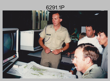
Photograph - Army Survey Regiment Open Day at Fortuna, Bendigo, 1990
These six photographs were taken at an Army Survey Regiment Open Day at Fortuna Villa, Bendigo on the 24th of February 1990. This occasion was one of several events held to commemorate the 75th anniversary of the formation of the Royal Australian Survey Corps. Although historical tours of Fortuna occurred on a regular basis, this was the first technical open day since 1972. The Royal Australian Survey Corps recognised that an Open Day was the best way for the local community in Bendigo to gain an insight into the unit’s important role as Defence’s map production agency, its technical equipment, and its economic importance to Bendigo. It also gave them an opportunity to tour through historic Fortuna Villa. This occasion is covered in more detail in page 143 of Valerie Lovejoy’s book 'Mapmakers of Fortuna – A history of the Army Survey Regiment’ ISBN: 0-646-42120-4. Refer to Item 6247.30P for more photos of the Open Day. These six photographs were taken at an Army Survey Regiment Open Day at Fortuna, Bendigo on the 24th of February 1990. The colour and black & white photographs were printed on photographic paper and are part of the Army Survey Regiment’s Collection. The photographs were scanned at 300 dpi. .1) - Photo, colour, 1990, AUTOMAP 2 L to R: SSGT Graham Johnston, SPR Grant Davis, civilian visitors. .2) - Photo, black & white, 1990. Photo Troop, WO2 Keith Fenton RE. UK Exchange. .3) - Photo, black & white, 1990. Aerotrig, SGT Bruce Hammond, civilian visitors. .4) - Photo, black & white, 1990. AUTOMAP 2 L to R: SPR Peter Smyth, LT Steve Hledik, SGT Martin Evans, MAJ Neil Taylor, Civilian visitors. .5) - black & white, Orthophoto Mapping, L to R: civilian visitors, SSGT Peter Imeson, civilian visitor, SGT Bob Garritty. .6) - black & white, Print Troop L to R: civilian visitors, SSGT Ian Nichols, CPL John ‘Flash’ Anderson..1P to .6P – there are no annotations.royal australian survey corps, army svy regt, rasvy, army survey regiment, fortuna, asr -
 Warrnambool and District Historical Society Inc.
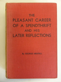
Book, The Pleasant Career of a Spendthrift and his Later Reflections, 1929
This book is an autobiography of George Meudell (1860-1936). He spent about six years in Warrnambool as a young boy when his father came to Warrnambool as the Manager of the Bank of Victoria. Meudell went to the Warrnambool Common School 646. He later became well-known in Melbourne in social, economic and political affairs. He was a company promoter, stockbroker and writer and an acquaintance of most of the influential and wealthy people of the time. In 1928 Meudell wrote an article for the Royal Historical Society of Victoria Journal detailing his memories of Warrnambool and this article is now a very important piece of local social history. He was enthusiastic about the benefits of living in Warrnambool in the 1860s and 70s. Meudell’s book, ‘The Pleasant Career of a Spendthrift, was an important publication as it gave a complete account of the commercial morality of the power brokers in the financial world - those concerned with the land boom and the banks’ crash of 1886-1893. The book was so inflammatory that it was initially withdrawn from sale. This book is of considerable interest as it was written by George Meudell who lived in Warrnambool in the 1860s and 70s and played a part in Warrnambool’s history by writing about these years. The book is also of wider interest as it has some information on people connected with Warrnambool’s history, including John Archibald and Thomas Bent. The signature in the front of the book is of no known relevance to Warrnambool.This is a hard cover book of 282 pages. The cover is red with black printing and the spine is very faded. The book has a foreword and twelve chapters of text. The first page contains a signature and notes written in pencil.‘Gordon Leitch Christmas 1942’ george meudell, victoria’s land boom (19th century), history of warrnambool -
 Kiewa Valley Historical Society
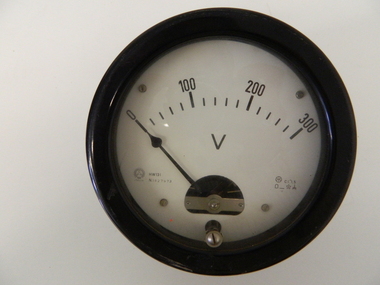
Meter Volt, mid to late 1900's
This analog voltmeter is quite a large (industrial type) apparatus which permits the easy monitoring of electrical variations within the large SEC Victoria Hydro Scheme's electrical generators. These generators are powered by the hydro force of "stored" water at a higher altitude. The establishment of both the NSW and Victorian Hydro schemes was achieved from the mid 1900's to the 1960's. At this point in time the need for additional power sources to quench both an industrial and domestic demand for electricity was purely an economic and not and environmental (carbon reduction) factor. This hydro scheme was instigated by "the Government of the day" as a bold move and was the major force of the World War II refugee and "technical" workforce inclusion of skilled and unskilled migration into the Australian environment. Although this mass "invasion" of workers with families was thought of in some circles as intrusive, the expansion of population post war years and its integration into the Australian rural sector, produced the multi- lingual multi-cultural diversity of later years. This voltmeter is very significant to the Kiewa Valley as its use was introduced during the Kiewa Hydro Scheme. Although only a small apparatus it was part of the explosion of human resources into the valley. This influx of population transformed the region from that of a basically quiet rural region to one which evolved into both an industrial and a larger residential community. This evolution in the valley created a change, not only in the "physical" landscape but also the socio-economic expansion which permitted other "tourist" based industries into the valley. This analog volt meter has two metal rods protruding from the "back" of instrument with screw on points for the negative and the positive leads allowing the "current" to flow across the calibrated resistors to indicate on the "face" side the strength of the voltage "power". The "face" of the instrument has a zero point and then five evenly graduated marks from Zero to the "100, 200 and 300" marked points of measures. A large "V" below these pointers indicates that they represent levels of voltage. Three small screws hold the "face" in place. At the back of the meter is an aluminium "clasp" with three protruding screws (positioning fasteners) and a a screw tightening fixture for the correct fastening of the "clasp" into the correction location on the meter "board".Manufacturer's logo "CSG" underneath "ITALIA"kiewa valley tourism, victorian alps, alternate energy supplies, alpine population growth -
 Kiewa Valley Historical Society
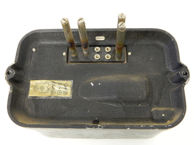
Relay Protection Instrument, Circa 1950's
This protection relay apparatus (a large electrical fuse), which permits the easy monitoring and disconnection of faulty electrical apparatus connected to the large SEC Victoria Hydro Scheme's electrical power producing generators. These generators are powered by the hydro force of "stored" water at a higher altitude. The establishment of both the NSW and Victorian Hydro Schemes was achieved from the early 1900's to the 1960's. At this point in time the need for additional power sources to quench both an industrial and domestic demand for electricity was purely an economic and not and environmental (carbon reduction) factor. This hydro scheme was instigated by "the Government of the day" as a bold move and was the major force of the World War II refugee and "technical" workforce inclusion of skilled and unskilled migration into the Australian environment. Although this mass "invasion" of workers with families was thought of in some circles as intrusive, the expansion of population post war years and its integration into the Australian rural sector, produced the multi- lingual multi-cultural diversity of later years.This protection relay is very significant to the Kiewa Valley as its use was introduced during the Kiewa Hydro Scheme. Although only a small apparatus it was part of the explosion of human resources into the valley. This influx of population transformed the region from that of a basically quiet rural region to one which evolved into both an industrial and a larger residential community. This evolution in the valley created a change, not only in the "physical" landscape but also the socio-economic expansion which permitted other "tourist" based industries into the valley.This protection relay unit has a black painted metal shell with four copper enclosed "prongs" fastened to the rear of the housing(from a bake-lite plate) . Between these "prongs" are four "empty" points allowing additional "screw on" bases. The front glass enclosed meter and recorder allows for the identification and automatic disconnection of any faulty equipment connected to the main power generator. This equipment acts similarly to a modern day circuit breaker found on the electrical circuit boards of residential homes.On the top section of the front panel "ASEA" to the left "Made in Sweden" and to the right "Frabrique en Suede" below this "RIS" below this a graph and next to it two columns of numbers and a pointer for each setkiewa hydro electricity scheme, victorian state electricity commission, relays, generators -
 Unions Ballarat
Book - Contemporary Labor Economics, Second Edition (D.J. Spiers Collection), McConnell, Campbell R. et al
Chapter titles: Chapter 1: Labor Economics Introduction and Overview -- Chapter 2: The Theory of Individual Labor Supply -- Chapter 3: Population, Participation Rates, and Hours of Work -- Chapter 4: Labor Quality: Investing in Human Capital -- Chapter 5: The Demand for Labor -- Chapter 6: Wage Determination and the Allocation of Labor -- Chapter 7: Alternative Pay Schemes and Labor Efficiency -- Chapter 8: The Wage Structure -- Chapter 9: Mobility, Migration, and Efficiency -- Chapter 10: Labor Unions and Collective Bargaining -- Chapter 11: The Economic Impact of Unions -- Chapter 12: Government and the Labor Market: Employment, Expenditures, and Taxation -- Chapter 13: Government and the Labor Market: Legislation and Regulation -- Chapter 14: Labor Market Discrimination -- Chapter 15: Job Search: External and Internal -- Chapter 16: The Distribution of Personal Earnings -- Chapter 17: Labor Productivity: Wages, Prices, and Employment -- Chapter 18: Employment and Unemployment.Relevance to union business.Book; paper.Front cover: authors' names and titles.btlc, ballarat trades and labour council, economics - labor, unions, collective bargaining, wealth distribution, employment -
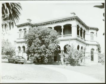 Kew Historical Society Inc
Photograph - 'Mandalay', 3 Molesworth Street (Kew), 1979
'Mandalay' at 3 Molesworth Street, Kew was originally named 'Kaikoura'. Pru Sanderson's 'Kew Urban Conservation Study' (1988) describes the house as: "The first documentary evidence of this property records that William Dawson was the original owner and occupier of this substantial two-storey mansion, built at the outset of the economic depression of the 1890s. Having an initial N.A.V. of £120 4, the house was occupied by Dawson until at least 1904. This two-storeyed rendered house is Italianate in styling and is dominated by a two-storeyed loggia that spans two facades. At ground floor level it is supported on coupled cast iron colonettes and above has single colonettes that support stilted segmental arches. The house is quite typical of its time, however it bears a strong resemblance to 39 Sackville Street probably by Beswicke and Coote (q.v.), and 'Kawarau'.in Hawthorn, designed by Coote. The similarity of these buildings and the fact that Beswicke and Coote called tenders for a house in Molesworth Street, both suggest that this house was also by that firm.Large original, black and white print positive photograph of 3 Molesworth Street, Kew The two storey Italianate mansion has a double loggia and two bay windows on the side of the property. A car is parked in front.manadaly - molesworth street (kew), historic houses -- kew, italianate architecture -- kew (vic.), kaikoura -- molesworth street -- kew (vic.), beswicke & coote -
 Wodonga & District Historical Society Inc
Decorative object - Bead and Snake bone necklace, Fred Walker, c1930
These beads were made by Fred Walker, then of Wodonga, during the Depression. He created them to make additional income when work was scarce. They were sold for 3 shillings per necklace. The snakes he caught were boiled to separate the flesh from the bones. After saturating the market in Wodonga, Fred and a friend took to the road. At one stage they travelled with live snakes which had been de-fanged and kept them alive with frogs until more necklaces were needed. He travelled much of the east coast of Australia until the economic conditions improved, when he settled in Melbourne. After the death of his wife in the mid 1970s, Fred took to the road again, resurrecting the making of snake jewellery as he travelled the countryside. These beads were purchased by Mrs. Lilian Black of Kergunyah, Victoria when Fred Walker visited her family farm in the 1930s.These beads demonstrate enterprising activities carried out by Australian people in order to survive during the Great Depression of the 1930s.A necklace made from black beads and treated snake bones. There are 5 coloured beads in the middle of the necklace.snake jewellery, the great depression, survival during the depression -
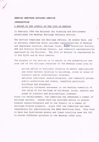 Bendigo Historical Society Inc.
Document - BENDIGO HERITAGE ADVISORY SERVICE: REPORT TO COUNCIL, JAN 1987
Bendigo Heritage Advisory Service - Report to Council, Jan 1987, This appears to be a draft report as there are handwritten changes on a number of pages. Report is set out in the form of an Introduction and a Summary. Advisory Service comprised Heritage Advisor, Andrew Ward; Bendigo and Eaglehawk Councils; National Trust; Bendigo Historical Society; MPE and Historic Buildings Council; community representatives??; City of Bendigo - Cr Rod Fyffe, Mr Norm Cameron. Recommendations - Changes to Planning Scheme; Policy encouraging reuse of Buildings; Adoption of Action Plans; Council to encourage Heritage based Tourism; Appropriate development applications encouraged. Attached are seven short papers on specific aspects of heritage planning - 1. a Statement of Bendigo's Significance; 2. The economic importance of heritage planning; 3. Planning Scheme heritage provisions; 4. Procedures for permits; 5. Action plans for Bendigo precincts; 6. Reuse of buildings; 7. Government incentives for heritage conservation., (this last one not attached as ''Already Circulated''.Bendigo Heritage Advisory Servicebendigo, council, heritage advisory committee, bendigo and eaglehawk councils. national trust, bendigo historical society, historic building council. reuse of buildings.