Showing 439 items
matching flowes
-
 Eltham District Historical Society Inc
Slide, Maroondah Aqueduct, Research, Victoria, 22 Mar. 1981
An inspection tour of the Maroondah Aqueduct was undertaken by the Shire of Eltham Historical Society on Sunday, March 22nd, 1981, commening where the aqueduct crosses Main Rd., Research, just below Eltham College. The Maroondah Aqueduct was part of Melbourne’s water supply system. It carried water over the 66 km from the Maroondah Reservoir on the Watts River at Healesville to the Preston Reservoir. Of this length, 41 km were open channel, 10 km, tunnel through hills and 15 km in 14 inverted siphons across stream valleys. The route of the aqueduct is north of Tarrawarra and Yarra Glen, along the Yarra escarpment south of Christmas Hills and crossing Watsons Creek into the present Shire of Eltham near Henley Rd. The eastern part of the route lies entirely within the former boundaries of the shire. The aqueduct passes south of Kangaroo Ground to Research and crosses the Diamond Creek by siphon at Allendale Rd., Eltham North. It then extends to Reservoir via St. Helena, Greensborough North and Bundoora. Water first flowed through the aqueduct in February 1891 when it was fed by a diversion weir on the Watts River. Records of the building of the aqueduct indicate that it was a significant construction achievement. The present Maroondah Reservoir was completed in 1927 and the aqueduct was enlarged at that time to take increased flows. About 1971 the section of the aqueduct through and north of Research was replaced by a large pipe and that section of the channel is now unused. The channel has remained largely intact (unlike sections at Greensborough and Bundoora where long lengths of the disused aqueduct have been demolished or filled in). The M.M.B.W. relinquished control of the disused aqueduct reserve which is crown land and the Shire of Eltham took control of this section of the reserve as a linear park. The Maroondah Aqueduct is considered to be an important historic structure, not just to the local area but to the metropolitan area generally. It is considered important to preserve substantially intact long lengths of the disused aqueduct, together with its bridges and other associated structures. 35 mm colour positive transparency (1 of 5) Mount - Agfachrome Agfa CS System black 8 dotsactivities, heritage excursion, maroondah aqueduct, research (vic.), shire of eltham historical society -
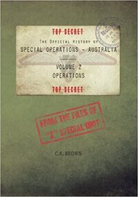 Australian Commando Association - Victoria
Book - Official History of Special Operations Australia- Volume 2 Operations
Popularly known today as Z Special Unit, or by the wartime cover names of Inter-Allied Services Department (ISD) and Services Reconnaissance Department (SRD), Special Operations Australia (SOA) was the Special Operations component of the US-led Allied Intelligence Bureau in the Pacific Theatre during the Second World War. From the secret files of Z Special Unit, and the second in a set of five volumes, Volume 2 - Operations describes almost two hundred separate "Z" Operations. Through the examination of this volume, the strategic role of the Special Operations - Australia organisation becomes apparent. Students of history will easily identify the ebb and flow of the Allied campaigns in the Pacific Theatre, with many of the operations of SOA being precursors to larger Allied offensives. Several serious blunders by SRD headquarters are also identified, one of which in particular had the capacity to compromise one of the greatest secrets of the Second World War and could have cost thousands of Allied lives...special operations australia, australian commandos, world war ii, special forces -
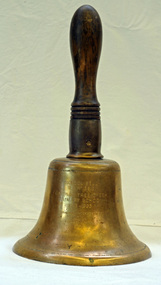 Orbost & District Historical Society
Functional object - Bell, hand-held, Early 20th century, c.1900s
The settlement of Cabbage Tree Creek is located on the Princes Highway, 27 km east of Orbost in East Gippsland. The creek, which flows through undulating forest, takes its name from the patches of Cabbage Fan palms growing along its course. A school commenced classes in 1913, but enrolment was small and at times the school operated part time with several other small schools in the area. The school building served as a hall for the district. About 1946 two sawmills commenced operations at Cabbage Tree Creek, and the Forests Commission ranger was stationed in the area. The increased population allowed the school to have more teachers and make improvements. In 1953, a new prefabricated building was erected on a new site. However, by the 1970s employment in the timber industry was unstable and the population decreased. By 1974 the school again had only one teacher and eventually closed in 1993 to amalgamate with the Orbost primary School in Ruskin Street, Orbost. (Ref. VictorianPlaces)The school bell is a signal that tells a school's students when it is time to go to class in the morning and when it is time to change classes during the day as well as when students are dismissed from school. In most schools today it will be a tone, siren, electronic bell sound, a series of chimes, or music played over an intercom but often still called "the school bell". This item reflects the history of Cabbage Tree Creek as well as the technological changes in the school system.Brass bell with incised double lines on bottom edge and top near handle, featuring descriptive notation on front face. Bell has long wooden handle shaped and incised with four lines at base before brass housing with singular screw holding handle in place. Object is showing signs of wear, with blackened handle and patches of green oxidisation.SCHOOL BELL / SS No 3812 / CABBAGE TREE CREEK / PRIMARY SCHOOL / 1913-1993 / FORMALLY INCORPORATED / INTO / ORBOST / PRIMARY SCHOOL / 1994cabbage tree, east gippsland, cabbage tree creek, cabbage tree creek primary school, orbost primary school, school bells -
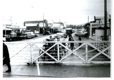 Wodonga & District Historical Society Inc
Photograph - High Street, Wodonga Level Crossing, 1954
This image is representative of many photographs illustrating the level crossing in the centre of Wodonga. Since its opening in 1873 the railway line had crossed High Street, originally called Sydney Road. It bisected the city with level crossing gates frequently stopping the flow of traffic and pedestrians as trains passed through. Signal Box B stood on the eastern side of the High Street level crossing and a big wheel closed and opened the gates. On 17th September, 1961, it was replaced by boom gates and flashing lights. The railway crossing was removed from High Street as part of the Wodonga Rail Bypass project. This involved a 5.5 kilometres bypass, the elimination of 11 level crossings and the relocation of the Wodonga station. It was moved from its original central location to a position on a new line on the northern edge of the town. The old station closed on 8 November 2008 and the new station opened on 25 June 2011.This image has local and statewide significance as it captures the former crossing in a major railway system. The railways played a critical role in opening up Victoria and connecting Australia for trade, business, social communication and transport.A black and white photo of the railway level crossing in High Street, Wodonga with gates closed. The Melbourne to Sydney railway line went through the centre of Wodonga and trains frequently held up internal vehicular and pedestrian traffic in the main street. railways wodonga, wodonga railway relocation, high st wodonga rail crossing -
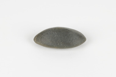 The Beechworth Burke Museum
Geological specimen - Ventifact (wind- or ice-shaped) pebble
Ventifacts are sand-blasted rocks that are typically faceted and often display parallel grooves carved by wind-blown sand. They are useful indicators of wind direction and strength in environments such as deserts, mountains, and coastal areas because they are usually not hidden by later sediment, soil or vegetation cover. In Antarctica ventifaction is strongly related to the composition or type of rock. Ventifacts are important because they provide evidence for abraders such as sand, dust or snow and ice crystals, and offer a unique understanding of past wind processes that are effective in the reconstruction of past wind flow conditions and can provides clues to weather and climate changes in the past. Interestingly ventifacts have also been found on the surface of Mars. They were a threat to the NASA rover due to the sharp angles of the facets, created by the Martian wind over the course of millions of years. These Martian ventifacts act like weathervanes for past wind and weather patterns on the red planet in a similar manner to those found on earth.The Geological Survey of Victoria was instigated in response to the Victorian Gold Rush which began around 1851 in the Beechworth, Castlemaine, Daylesford, Bendigo and Ballarat areas. The survey was conducted by Alfred Richard Cecil Selwyn from his arrival in December 1852 until his resignation in 1869and during this time he trained many notable geologists, e.g. Aplin, Wilkinson, Daintree, who went on to other State survey senior positions. This specimen was among those donated to the Burke Museum in 1868.A hand-sized solid mineral specimen in shades of dark and light browns with light lines visible in all configurations and a groove on configuration 2.light lines visible in all configurations and a groove on configuration 2burke museum, beechworth, geological, geological specimen, ventifact, antarctic region, antarctic, alfred richard cecil selwyn, alfred selwyn, wind direction, wind strength, abraders, wind flow, climate change, reconstruction of wind flow conditions, weather change, mars -
 Whitehorse Historical Society Inc.
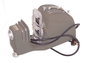
Functional object - Slide/Film Strip Projector, c1960
The donor received the projector from a relative. He used it in the City of Whitehorse and surrounding areasWaterworth Slide Film Strip Projector, Model A - 300 watt, without a fan but with ventilating slots on top and an open bottom for air to flow. It has a carrying handle and a power lead with 3 pin plug which is wired in permanently. The projector lamp is at rear under the carrying handle. Image is projected through three stage lens via via the image on the 35mm strip or slide. The front lens is adjustable for focus. A knurled nut enables a height adjustment at front. Slides are inserted through the holder - whilst one slide is shown the other can be loaded ready to be slid in front of the light. The film strip holder is missing. The unit is finished in a grey hammer finish paint used in 1960 t0 1980s. The operating instructions are filed in the supplementary envelope. The projector is stored in a hand made three ply hinged box.Waterworth Hobart 5553Aphotography, projectors -
 Kew Historical Society Inc
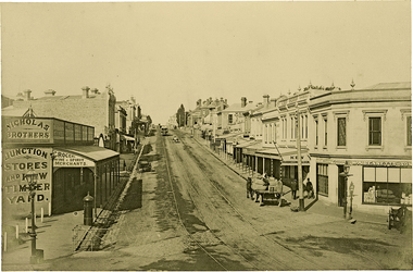
Photograph, J F C Farquhar, High Street, Kew, 1891
At the beginning of the 1890s, the Kew businessman and Town Councillor, Henry Kellett, commissioned J.F.C. Farquhar to photograph scenes of Kew. These scenes included panoramas as well as pastoral scenes. The resulting set of twelve photographs was assembled in an album, Kew Where We Live, from which customers could select images for purchase.The preamble to the album describes that the photographs used the ‘argentic bromide’ process, now more commonly known as the gelatine silver process. This form of dry plate photography allowed for the negatives to be kept for weeks before processing, hence its value in landscape photography. The resulting images were considered to be finely grained and everlasting. Evidence of the success of Henry Kellett’s venture can be seen today, in that some of the photographs are held in national collections.It is believed that the Kew Historical Society’s copy of the Kellett album is unique and that the photographs in the book were the first copies taken from the original plates. It is the first and most important series of images produced about Kew. The individual images have proved essential in identifying buildings and places of heritage value in the district.In 1891, High Street was the centre of commercial activity in the Borough of Kew. It was unpaved and edged with deep bluestone gutters, which were designed to channel the significant flow of storm water down the hill to and beyond the Junction. On either side of the entrance to the shopping strip are two cast iron gas lamps that provided the only public street lighting before the Post Office was reached. Most shops, including the Nicholas Brothers’ Junction Store featured cast iron verandas. Further up the hill, Dougherty’s Greyhound Hotel was by this stage a local institution. Apart from the horse-drawn tram, the main form of personal and commercial transport in this period remained the horse, horse and cart, or buggy.The panoramic view predates the widening of High Street in the 20th century, and thus includes the original alignment of buildings on the south side. These included Henry Kellett’s shop.High Street, Kewkew illustrated, kew where we live, photographic books, henry kellett, high street - kew (vic) -
 The Beechworth Burke Museum
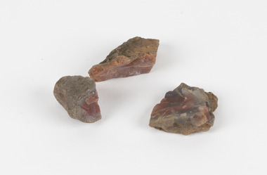
Geological specimen - Unknown, possible Carnelian Agate or Chalcedony
Although it is not known where these specimens were collected, Victoria and other regions of Australia were surveyed for sites of potential mineral wealth throughout the 19th Century. The identification of sites containing valuable commodities such as gold, iron ore and gemstones in a locality had the potential to shape the development and history of communities and industries in the area. The discovery of gold in Victoria, for instance, had a significant influence on the development of the area now known as 'the goldfields', including Beechworth; the city of Melbourne and Victoria as a whole. Agate occurs when amygdales (gas pockets) form in the upper levels of basaltic lava flows. If these pockets or bubbles are iniltrated by water bearing silica in solution, the fluid dries and hardens in layers, forming round or egg shaped nodules or geodes within the rocky matrix. Agate is formed of a silica mineral chalcedony similar to quartz. The term carnelian primarily refers to the reddish shading of the stone; whether the stone is termed an agate or chalcedony type is often influenced by the degree of colour banding the specimen shows. The specimens are significant as examples of surveying activity undertaken to assess and direct the development of the mineral resource industries in Victoria and Australia, as well as the movement to expand human knowledge of earth sciences such as mineralogy and geology in the nineteenth century.Three small geological specimens that appear visually consistent with images of rough or unpolished Carnelian Agate or Chalcedony. geological specimen, geology, geology collection, burke museum, beechworth, indigo shire, north-east victoria, gemstones, agate, carnelian -
 Flagstaff Hill Maritime Museum and Village
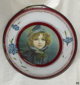
Decorative object - Flue Cover Art, 1890s to 1930s
In the late 19th and early-20th centuries household heaters burned wood and coal for heating. In winter the warm air from the fireplace would flow into the room through a round flue in the face of the chimney. In the warmer months the unnecessary heater and flue was removed and the chimney cleaned. Homemakers then covered the circular flue hole with a decorative and usually inexpensive wall hanging to prevent draughts and dust. The practice was especially popular in France and Germany where a lot of the artwork originated. The covers were no longer needed after households changed over to more modern designs of heaters. The flue covers were known as Wall Art or Flue Cover Art. They were usually round and illustrated with a lithograph or chromograph print. The picture was then mounted on card, covered with glass, and framed with a brass or tin rim. The border was commonly gilt with a black stripe around the centre. There were numerous illustrations, many with a European appearance, and were easily bought through local merchants for a small price.This pretty flue cover is significant for representing a common domestic wall decoration from the late Victorian to the Edwardian eras, when solid fuel heaters were used in low to high income homes. The picture is similar to many other flue cover images, apart from the holly clutched in the girl’s hand, which gives the cover a Christmas theme. This flue cover is the only one in our collection and appears to have a unique design; the hand painted floral decoration on the glass and the two crimson rings around the edges of the frame’s white border haven’t been seen on other flue covers. Flue cover, metal and glass. Print of a young girl with blue eyes and curly blonde hair, a hooded blue cape, a silver clasp with blue stones, and a sprig of holly in her hand. The round metal frame forms a deep, white-painted, crimson-edged border for the illustration. The hand-painted blue flowers on the glass front form add to the border and give a 3-dimensional effect. The picture is between the cardboard backing and the glass front, with the metal frame holding them together. There is a metal chain attached for hanging the cover.warrnambool, flagstaff hill maritime museum, picture, handpainted, portrait, girl in blue cape, metal frame, round picture, illustration, print, holly, christmas, child in blue cape, silver and blue clasp, holly sprig, late 19th century, early 20th century, 1890s-1930s, victorain, edwardian, flue cover, flue cover art, wall art, chimney flue cover, chimney hole cover, stove pipe cover, fireplace flue cover, antique, victorian, glass frame, chromograph, lithograph, tin, brass, lithograph print, chromo print, christmas girl, blue cape, blonde girl -
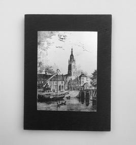 Dutch Australian Heritage Centre Victoria
Etching
The Vliet is a canal in the western Netherlands, in the province of South Holland. It starts at the Oude Rijn at Leiden and joins the Delfshavense Schie canal at Delft. Places along its banks include Voorschoten, Leidschendam, Voorburg, The Hague and Rijswijk. The canal was dug in 47 AD under command of Roman general Corbulo, who wished to connect the river Rhine, of which the current Oude Rijn stream in Roman times was the main branch, to the Meuse estuary. It is unclear what the canal's trajectory was beyond the current city of Delft; the Delfshavense Schie canal, which connects Delft to the Nieuwe Maas river was not dug until 1389. In the Middle Ages the Vliet was an important trade link that attracted all kinds of trade, as it flowed through the heart of the County of Holland. Windmills have been constructed alongside the Vliet, including the completely renovated mill 'De salamander' in Leidschendam. The Vliet area was particularly attractive among richer families, who built their mansions along its banks.An historic small town scene etched (or possibly printed) on thin metal and subsequently fastened to a plywood backing. The delicately presented scene is said to show the intersection of Old Church Street and the Vliet Canal bridge in Voorburg, as well as a section of wharf. On the canal are one large and two much smaller vessels. A very tall crane-like construction arises from the wharf to the roof of waterside buildings. The people are soberly dressed in possibly 17th or 18th century costumes.On the reverse has been written: "Oude Kerkstraat Brug over de Vliet Voorburg". (Old Church Street; Bridge over the Vliet canal; Voorburg). However, research proves that the church is actually the Old Church in Delft, a short distance further down the Vliet Canal. -
 Kew Historical Society Inc
Photograph - Civic event in Stradbroke Park, 1976
Stradbroke Park. Extent: Kilby Road to Harp Road at Burke Road. Historical Documentation: 1851 - Portion 91 purchased by Edward Glynn; 1888 - The Harp of Erin Estate (which included Section 91) offered for sale; 1896 - The area now known as Stradbroke Park was bisected by a creek that flowed from the Yarra via Hay's Paddock (q.v.) and extended through to Burke Road; 1943 - W.D. Birrell, Town Clerk of Kew, proposed that the creek be filled and a reserve created; 1954 - Entire area designated as 'open space' and named 'Stradbroke Park'. The line of the creek that ran through the Park created a further reserve on the north side of High Street, now known as 'Harrison Reserve'. Existing Condition: The park is largely of mown grass that has mature trees set into it It is possible that a number of these are remnant of the original vegetation, while there are also a number of exotic trees introduced, particularly at the northern end of the park. The southern end is dominated by playing fields. (Source: Sanderson, P 1988. Kew Conservation Study)Colour photographic positive (with colour degradation) of sporting teams at a civic event in Stradbroke Park in Kew East in May 1976. The event was officiated by the Mayor of Kew, Cr Alan Hutchinson. Sporting teams in uniform included: footballers, athletes, cricketers, hockey players. Stradbroke Park is situated on the western boundary of Kew at Burke and Harp Roads.stradbroke park, cr alan hutchinson, team sports -- kew (vic.) -
 Kew Historical Society Inc
Photograph - Civic event in Stradbroke Park, 1976
Stradbroke Park. Extent: Kilby Road to Harp Road at Burke Road. Historical Documentation: 1851 - Portion 91 purchased by Edward Glynn; 1888 - The Harp of Erin Estate (which included Section 91) offered for sale; 1896 - The area now known as Stradbroke Park was bisected by a creek that flowed from the Yarra via Hay's Paddock (q.v.) and extended through to Burke Road; 1943 - W.D. Birrell, Town Clerk of Kew, proposed that the creek be filled and a reserve created; 1954 - Entire area designated as 'open space' and named 'Stradbroke Park'. The line of the creek that ran through the Park created a further reserve on the north side of High Street, now known as 'Harrison Reserve'. Existing Condition: The park is largely of mown grass that has mature trees set into it It is possible that a number of these are remnant of the original vegetation, while there are also a number of exotic trees introduced, particularly at the northern end of the park. The southern end is dominated by playing fields. (Source: Sanderson, P 1988. Kew Conservation Study)Colour photographic positive (with colour degradation) of sporting teams at a civic event in Stradbroke Park in Kew East in May 1976. The event was officiated by the Mayor of Kew, Cr Alan Hutchinson. Stradbroke Park is situated on the western boundary of Kew and bordered by Burke and Harp Roads.stradbroke park, cr alan hutchinson, team sports -- kew (vic.) -
 Stawell Historical Society Inc
Photograph, Fluming Water Supply in the Grampians 1991 -- 9 Photos -- Coloured
Coloured photos of Fluming Water Supply in the Grampians. a. Grampians Exit of tunnel through Mt William Range built 1874. b. Halls Gap Fyan's Creek with buried pipe from new diversion Weir Nov 24/91 (Fume Main). c. Halls Gap New Diversion Weir (Keith Phillips) Nov 24/1991. d. Halls Gap Old pipe to open flume adapter Nov 24/1991. e. Halls Gap Old metal open flume Nov24/91. f. Halls Gap Old metal flume and man made stone supporting wall. g. Halls Gap Overhanging rocks above old fume line Nov 24/1991. h. Halls Gap Old pipe to open flume adapter Bill Holmes Nov 24/91. i. Grampians Old hut for controlling flow valves etc. at Stawell side of Mount William Range after tunnel exit. Nine colour photographs of various views around a tunnel through a hill site.grampians water supply flume -
 Federation University Historical Collection
Book, Memoirs of the Geological Survey of Victoria No 14 The Ballarat Goldfields, 1923, 1923
William Baragwanath was educated at the Ballarat School of Mines, obtaining a Geology Certificate in 1911. After further study he went on the become Secretary for Mines, and Chief Mining Surveyor. Baragwanath was a Councillor of the Ballarat School of Mine from 1916 to 1950.Pink covered foolscap book of 257 pages and 32 maps and plans by William Baragwanath. Contents include topography, physiography, historical, geology, basalt, faults, dykes, minerals leads, alluvial mines, nuggets, structure of Ballarat West goldfields, structure of Ballarat East gold-field, quartz formation, indicators, defunct mines, existing mines, table of deepest shafts. Images include: section of the Ballarat Gold-Field, Dead HOrse Flat, lakes formed by Basalt Flows, Gong Gong Creek, Frenchman's Lead, Ballarat West Mines, LEases and positions of shafts (1857), puddling, White Horse Lead, Woah Hawp Canton, Ballarat Township mines, Sebastopol, syncline, Victoria United Line, First Chance Mine, Llanberris No 1 Mine, Saddle Reef, New Normanby Mine, Woah Hawp Canton Mine, South Star Mine, Sebastopol Plateau, south Woah Hawp Mine, Woah No. 2 Minegeology, geological survey no 14, ballarat, baragwanath, william baragwanath -
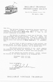 Ballarat Tramway Museum
Document - Letter/s, Ballarat Tramway Preservation Society (BTPS), "Ballarat Vintage Tramway - Horse Tram No. 1 Restoration Project", Apr. 1986
Set of three items concerning the restoration project for Horse Tram No. 1, by the Ballarat Vintage Tramway, 1986. 2804.1 - Letter on BTPS Letterhead, dated 8/4/1986, standard letter, seeking sponsorship or financial assistance for the project. Drafted for a Trust. Signed by the President, Frank Hanrahan. 2804.2 - 12 page report comb bound, with clear plastic cover, preprinted cover featuring horse tram No. 7 and light card rear back cover, dark blue in colour. Report gives an introduction, notes on the Ballarat Horse tram service, photos, notes on the BTPS, the project itself, costings, a elevation drawing of the horse tram, operation, sponsorship details, details of the Board, costs and times, and work program and expected cash flow. 2nd copy added 6/2/2005. 2804.2 - ditto, but stapled in top right hand corner. Images added 28/11/2016.trams, tramways, horse tram, submissions, btps, restoration -
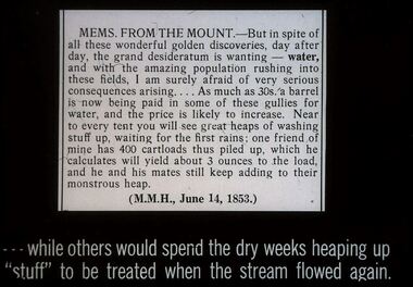 Bendigo Historical Society Inc.
Slide - DIGGERS & MINING. GETTING THE GOLD, c1850s
Diggers & Mining. Getting the Gold. Slide: MEMS FROM THE MOUNT - But in spite of all these wonderful golden discoveries, day after day, the grand desideratum is wanting - water, and with the amazing population rushing into these fields. I am surely afraid of very serious consequences arising . . . . As much as 30s. a barrel is now being paid I some of these gullies for water, and the price is likely to increase. Near to every tent you will see great heaps of washing stuff up, waiting for the first rains; one friend of mine has 400 cartloads this piled up, which he calculates will yield about 3 ounces to the load, and he and his mates still keep adding to their monstrous heap. (M.M.H., June 14, 1853.) . . .while others would spend the dry weeks heaping up ''stuff'' to be treated when the stream flowed again Markings: 68 994.LIF:4. Used as a teaching aid.hanimounteducation, tertiary, goldfields -
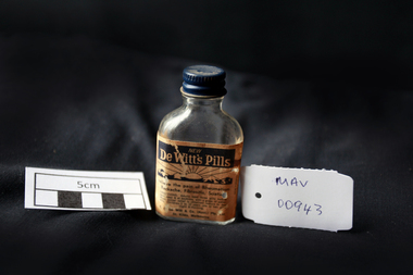 City of Moorabbin Historical Society (Operating the Box Cottage Museum)
Manufactured Glass, bottle of 'De Witts Pills', mid 20thC
De Witt's Kidney and Bladder Pills were produced by a firm founded in 1912 by E C De Witt, Cheshire UK, with branches in New Zealand, Chicago and New York. It became part of the CB Fleet Group in 1990, whose UK operation is currently based in Runcorn, Cheshire where they still manufacture toiletries, skin care products and pharmaceutical products. Aimed at adults and children above the age of eight, De Witt’s Kidney and Bladder Pills were intended to ease backache, aches and pains in the muscles, and kidney problems. They are typical of a huge range of treatments that were available ‘over the counter’ at pharmacists for many years. It is not known how effective the pills were but the label assures people not to be alarmed if their urine takes on a bluish colour after taking a dose. The indications or uses for this product as provided by the manufacturer are: A diuretic stimulant for the kidneys to promote the flow of urine, combined with analgesic action. Aids in alleviating muscular aches and pains, restlessness, dizziness, backache, headache, getting up at nights, loss of energy if caused by sluggish kidneys. An empty clear glass bottle with a metal screw top lid that contained De Witts Pills Front Label : NEW / DE WITT'S PILLS / rising sun trade mark / Relieve the pain of Rheumatism / Backache, Fibrositis, Sciatica / DIRECTIONS ......../ R.C.De Witt & Co (Aust) Pty Ltd. / St. Kilda Melbournepharmacy, medicines, glassware, bottles, moorabbin, bentleigh, cheltenham, de witt company ltd, cheshire england, cb fleet group ltd, glass manufacturers -
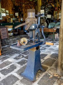 City of Moorabbin Historical Society (Operating the Box Cottage Museum)
Machine - Dairy, Milk Separator manual, c1900
A separator is a centrifugal device that separates milk into cream and skimmed milk. Separation was commonly performed on farms in the past where farmers milked a few cows, usually by hand, and separated by letting milk sit in a container until the cream floated to the top when it could be skimmed off by hand. Some of the skimmed milk was consumed while the rest was used to feed calves and pigs. Enough cream was saved to make butter, and the excess was sold. Manual rotation of the separator handle turns a mechanism which causes the separator bowl to spin at thousands of revolutions per minute. When spun, the heavier milk is pulled outward against the walls of the separator and the cream, which is lighter, collects in the middle. The cream and milk then flow out of separate spouts. Montgomery Ward was founded by Aaron Montgomery Ward in 1872.as a mail-order business in Chicago, Illinois USA. Rural customers were attracted by the wide selection of items that were unavailable to them locally and were also inspired by the innovative company policy of "satisfaction guaranteed or your money back".This milk separator is typical of the type used by early settlers in Moorabbin Shire where every family owned a 'house cow' to supply their dairy needs. Households also kept a few chickens for eggs and developed a vegetable garden with additional fruit trees. A 'primrose' manual milk separator 'Montgomery Ward', Chicago USA c1900'primrose ' / SATTLEY / MONTGOMERY WARD/ CHICAGOearly settlers, dairy farmers, milk products, dairies, market gardeners, blacksmiths, tools, moorabbin shire, bentleigh, mckinnon, highett, cheltenham, moorabbin -
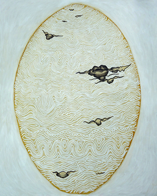 National Wool Museum
Painting, Dr Deanne Gilson, Yaluk, Beek, Murrup (Water, Country, Spirit), 2016
My name is Deanne Gilson and I am a proud Wadawurrung woman living on my ancestral Country around Ballarat in Victoria. My practise aims to highlight and bring back traditional women’s symbols and ceremonial practises that reference the lived experience of my ancestors. By reviving traditional marks found on artefacts and women’s business, I am forming links with past ancestral knowledge so that is not lost and continues for the future generations. My art practice relies heavily on the use of symbols and form as a metaphor for the body. I have worked as a full-time artist for over thirty-five years. Many artworks tell stories of the spiritual aspects of culture and myths. Dreaming and Songlines, further creating a yarning space, bring the gap towards reconciliation and healing for my people and others through shared sharing stories. A main focus of my art practice tells the birthing tree and scar tree stories and how Wadawurrung women have evolved and survived, since before and after colonisation. The old symbols find new life, connecting to the contemporary ones, further connecting us all to this Country we all call home.Yaluk, Beep, Murrup, meaning Water, Country, Spirit, incorporates the traditional mark of the wave pattern (often found on wooden shields) used by my ancestors, along with the basalt plains across Wadawurrung Country. By depicting the interaction between the Water and Country, I use ancestral knowledges that are not seen but intuitive to myself, while juxtaposing them against the ancestral stone circle knowledges, embedded with the DNA of our stories. The ochre is reclaimed as real, it is marni-beek, meaning Country, in particular the white ceremonial ochre, often seen on the painted-up figure and used today to reconnect back to our ancestral memory. Reclaiming what was lost through colonisation, but still present in our Dreaming that flows on today through the water spirit. Country has no time limits and water connects to our bodies, which are made up of water. We as a clan, are still here today, living and being on Country, our ancestral spirits live on through us. The original painting is a contemporary account of using ochre to reclaim ancestral knowledge and to be part of the ceremony that is yaluk, beep, murrup. wadawurrung, deanne gilson, water, country, spirit, first nations art -
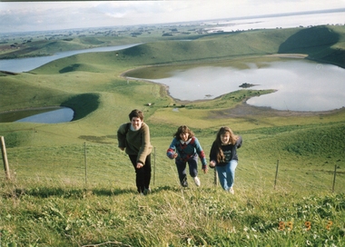 Ballarat Heritage Services
Photograph - Photograph - Colour, Kathleen Gervasoni, Red Rock, Alvie, 1989, 02/09/1989
Red Rock, Alvie, near Colac, is a complex of approximately 30 volcanic eruption points and is the Southern most of a chain of three volcanoes, the others being Warrion Hill and Alvie Hill. It is arguably the youngest eruption point in Victoria at around 8000 years, especially since the age of Mt Napier has been progressively pushed back. The highest point (on the Northern side) has many interesting features, including some awesome spatter ramparts. Driving around the rim to the south, you can also see layered tuff. There are some good views out to Lake Corangamite and the lava flows (probably from Warrion Hill) can be seen where they have entered the lake. Most of Red Rock is in private land, with two lookout points with some interpretive information. The water depicted in this photograph is not evident in 2019. Type: Volcanic Complex Location: South of Alvie, Victoria Last Eruption: 8000 years ago Access: Mostly private land, but there is an access road and some interpretive signage Visited: Visited Colour photograph of sisters Clare Gervasoni (left), Ann Gervasoni (centre) and Lisa Gervasoni and Red Rock, Alvie clare gervasoni, lisa gervasoni, ann gervasoni, red rock alvie -
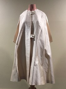 Kew Historical Society Inc
Clothing - Cream Silk Evening Cape, House of Youth, 1960s
THE HOUSE OF YOUTH label was founded c.1935) by Mr. Samuel Stein. By 1955 Mrs. Stein, his son, Philip, and his daughter, Elizabeth, all played an active part in the business. The connection with Dior came to them without seeking. Dior, that man of fashion genius, had come to the conclusion that the Australian market offered a scope he could not afford to ignore. He questioned many visitors to Paris and decided that the House of Youth was the obvious channel through which his designs should flow to the Australian woman. Completely versatile, this firm is capable of covering every phase of fashion production, from impeccably tailored suits and coats to softly draped, intricately cut dresses and evening gowns. Mr. Philip Stein was modest when asked what Dior thought of their copies, but confessed that Dior, had been "very flattering". Dior had-been greatly impressed with the standard of Australian craftsmanship, and, as a result of the success of this joint Parisian-Australian fashion venture, it is whispered that the great man himself is seriously contemplating a visit to Australia. (Source: The Argus 22 Feb 1955)The Fashion & Design collection of the Kew Historical Society includes examples of women’s, men’s, children’s and infants’ clothing from the 18th, 19th and 20th centuries. Items in the collection were largely produced for, or purchased by women in Melbourne, and includes examples of outerwear, protective wear, nightwear, underwear and costume accessories.Three quarter length flared cream coloured silk cape caught at the neck and waist with two large buttons covered with the same coloured fabric.Label: House of Youthwomen's clothing, house of youth, evening coats, australian fashion - 1960s -
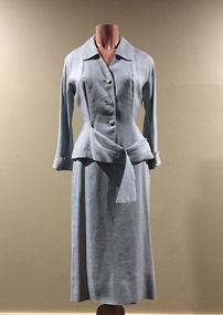 Kew Historical Society Inc
Clothing - Pale Blue Linen Suit, House of Youth, 1950s
THE HOUSE OF YOUTH label was founded c.1935) by Mr. Samuel Stein. By 1955 Mrs. Stein, his son, Philip, and his daughter, Elizabeth, all played an active part in the business. The connection with Dior came to them without seeking. Dior, that man of fashion genius, had come to the conclusion that the Australian market offered a scope he could not afford to ignore. He questioned many visitors to Paris and decided that the House of Youth was the obvious channel through which his designs should flow to the Australian woman. Completely versatile, this firm is capable of covering every phase of fashion production, from impeccably tailored suits and coats to softly draped, intricately cut dresses and evening gowns. Mr. Philip Stein was modest when asked what Dior thought of their copies, but confessed that Dior, had been "very flattering". Dior had-been greatly impressed with the standard of Australian craftsmanship, and, as a result of the success of this joint Parisian-Australian fashion venture, it is whispered that the great man himself is seriously contemplating a visit to Australia. (Source: The Argus 22 Feb 1955)Unlined pale grey linen two-piece suit with a fabric belt attached. The suit has the label "House of Youth Model" which may indicate that it is a licensed copy of a French original.Label: "House of Youth Model"women's clothing, australian fashion - 1950s, dresses, house of youth -
 Bendigo Historical Society Inc.
Document - FRANK CUSACK: 'THE GERMAN CONTRIBUTION TO EARLY BENDIGO'
'The German Contribution to Early Bendigo' ( 23rd Feb) 1986 lecture by Frank Cusack on the occasion of the 130th anniversary of the first Lutheran service in Bendigo). Origins of the large flow of Germans to the goldfields (failure of liberalism at home; conscription threat). Mention of George Bruhn, Menge (opal discoverer), Jacob Brahe; Ballerstedt; Wittscheibe; Schlemm; Ernst Mueller; Morris Collman; Louis Samuels; Gustave Adolphus Hugo Thureau; Backhaus; Pastor Friedrich Leypoldt; various German vignerons; ''The Hamburg'' (hotel); ''The Berlin'' (hotel); ''The European'' (hotel); Deutsche Verein; Paul Bucholz; Herr Gollmick; Early architects - Getzschmann, Bosselmann, Nicolai, Emil Mauermann, Friedrich Lehmann; Medical people - Dr Barnett; , Dr Landvoigt. Dr Sandner Snr.; others - Conrad Meyerhoff (patent gold cradle), Benno Sluytmann (first electricity plant in Bendigo), Gustavus con Tempsky (re Burke & Wills expedition), Ludwig Becker (Burke & Wills expedition); Josef Von St. Nicolai (Freemasonry); Captain Von Paleski.Frank Cusackbendigo, mining, early german history, german diggers, diamond hill, mangurang, mexican enclave at eaglehawke, irish town, back creek, ironbark gully, white hills, georg bruhn, menge, jacob brahe. old bendigo cemetery. -
 The Beechworth Burke Museum
Photograph - Lantern Slide, c1900
This image shows a view of a properties bordering a river in the vicinity of Beechworth in approximately 1900. Although the exact location of the photograph is yet to be determined, the water source pictured may feed into the bigger system that flows through Beechworth Gorge. A man wearing a hat, possibly the photographer, is silhouetted in the foreground of the picture. Lantern slides, sometimes called 'magic lantern' slides, are glass plates on which an image has been secured for the purpose of projection. Glass slides were etched or hand-painted for this purpose from the Eighteenth Century but the process became more popular and accessible to the public with the development of photographic-emulsion slides used with a 'Magic Lantern' device in the mid-Nineteenth Century. Photographic lantern slides comprise a double-negative emulsion layer (forming a positive image) between thin glass plates that are bound together. A number of processes existed to form and bind the emulsion layer to the base plate, including the albumen, wet plate collodion, gelatine dry plate and woodburytype techniques. Lantern slides and magic lantern technologies are seen as foundational precursors to the development of modern photography and film-making techniques.This glass slide is significant because it provides insight into Beechworth's built environment and natural landscape in the early Twentieth Century, around the time of Australia's Federation. It is also an example of an early photographic and film-making technology in use in regional Victoria in the time period.Thin translucent sheet of glass with a square image printed on the front and framed in a black backing. It is held together by metals strips to secure the edges of the slide.burke museum, beechworth, lantern slide, slide, glass slide, plate, burke museum collection, photograph, monochrome, photographer, beechworth gorge, river, stream, water source, 1900s -
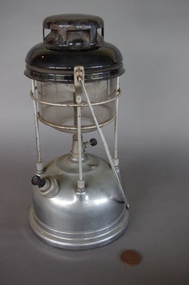 Upper Yarra Museum
Lamp, Tilley Lamp Company
http://en.wikipedia.org/wiki/File:Tilley-storm-lantern-X246-May- Tilley storm lantern, this model has been in production since 1964 The Tilley Lamp derives from John Tilley’s invention of the hydro-pneumatic blowpipe in 1813 in England. http://en.wikipedia.org/wiki/Kerosene_lamp#Pressure_lamp Pressure lamps are far more sophisticated than wick lamps and produce a much brighter light, although they can be quite complicated and fiddly to use. This type of lamp is commonly known in the UK as a "Tilley lamp", after a manufacturer of the same name, and in North America as a "Coleman lantern" for similar reasons. A kerosene blowtorch displaying the various aspects of the kerosene burnerA pressure lamp has a fuel tank at the bottom with a small pump to pressurise the kerosene. There is a narrow gap up to the top of the lamp, called a flue, and at the top of the lamp there is a burner (gas outlet). Directly underneath the burner is the mantle, a fabric bag coated with chemicals that incandesce when heated by the gas flame. The burner lamp is known for its brightness. It is so bright because of the amount of pressure that is placed onto the wick. This pressure allows a steady flow of the gasoline and a constant light Tilley Storm Pressure Lantern, model no x246 has a stainless steel base which is filled with kerosene, with a pump used to pressurize the kerosene vapor. Under the base is a sticker.On top is a black hood with vents which sits on the glass heat resistant shade. The glass shade has an etched label. It has a white and pink mantle on the central rod with a long shaped stainless steel handle, this folds down when not in use.Base - Sticker Tilley Lamp Model X246 Etched on glass shade Tilley, Durosil, ITI, Heat Resistant. Made in Englandlantern tilley pump pressure mantle kerosene methylated spirits stainless steel lamp kerosene lamp round glass cylinder -
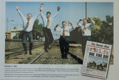 Wodonga & District Historical Society Inc
Photograph - One Fine Day - decision to move Wodonga Railway Line, 2000
On December 1, 2000 it was finally announced that the railway line would be moved away from the centre of the Wodonga CBD after many years of lobbying. Since its opening in 1873 the railway line had crossed High Street, originally called Sydney Road. The railway had bisected the city with level crossing gates frequently stopping the flow of traffic as trains passed through. The Wodonga Rail Bypass project moved Wodonga station from the original central location to a position on a new line on the northern edge of the town. Not only did this release land in the middle of the city for commercial and public use, but also eliminated 10 level crossings. The project actually commenced in 2008 with the last passenger train passing through Wodonga on 8 November 2008. On 23 July 2010, the new rail bypass was opened, and the original line through Wodonga closed. In this image the decision is celebrated by the Member for Indi, the Honourable Lou Lieberman, Deputy Prime Minister and Transport Minister John Anderson, Wodonga Mayor Cr. Graham Crapp and General Manager of Uncle Ben's Australia, Mr Bob Kennedy.This image commemorates a significant occasion in the development of the Central Business District of Wodonga, Victoria.A framed photo of four men celebrating the decision to move the railway out of the centre of Wodonga as well as an image of the from page of the Border Mail newspaper.wodonga railway, wodonga rail bypass, city of wodonga -
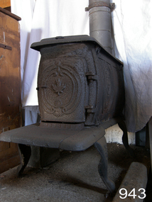 Flagstaff Hill Maritime Museum and Village
Domestic object - Stove, 1850-1890
In the industrialized world, as stoves replaced open fires and braziers as a source of more efficient and reliable heating, models were developed that could also be used for cooking, and these came to be known as kitchen stoves. The first manufactured cast-iron stove was produced at Lynn, Mass., in 1642. This stove had no grates and was little more than a cast-iron box. About 1740 Benjamin Franklin invented the “Pennsylvania fireplace,” which incorporated the basic principles of the heating stove. The Franklin stove burned wood on a grate and had sliding doors that could be used to control the draft (flow of air) through it. Because the stove was relatively small, it could be installed in a large fireplace or used free-standing in the middle of a room by connecting it to a flue. The Franklin stove warmed farmhouses, city dwellings, and frontier cabins throughout North America. Its design influenced the development of the pot-bellied stove, which was a familiar feature in some homes well into the 20th century. The first round cast-iron stoves with grates for cooking food on them were manufactured by Isaac Orr at Philadelphia, Pa., in 1800. The base-burning stove for burning anthracite coal was invented in 1833 by Jordan A. Mott. The subject item is a mid to late 19th century settlers stove probably of Canadian manufacture imported into Australia around this time. The stove gives us a social snapshot into what life must have been like for our early colonialists using this device for heating and cooking in their meagre homes. Cast iron stove with four-legs, 2 plates on top and a hinged front door. The door has been cast with a maple leaf design and the sides have a pattern cast into them.flagstaff hill, warrnambool, shipwrecked-coast, flagstaff-hill, flagstaff-hill-maritime-museum, maritime-museum, shipwreck-coast, flagstaff-hill-maritime-village, stove, domestic heating, domestic cooking, heater, cooking unit, pot belly stove, wood fired stove, wood stove -
 Federation University Historical Collection
Equipment - Computer - Logic Analyzer, Hewlett Packard, Logic Analyzer 1615a
The Logic Analyser was purchased by the Ballarat College of Advanced Education Physics Department in the early 1980s. At the time it was a state of the art piece of test equipment used for fault finding and programming diagnostics for 8 bit computers. It was later used by the Electrical Engineers, after Physics merged with Engineering in the mid 1990s. The device monitored the 16 bit Address buss and 8 bit Data buss of an 8 bit computer. This device continually samples the 24 bits simultaneously and looks for a preset pattern. When the pattern is matched the logic analyser continues for a set number of steps thus allowing an operator to examine the data and address information both leading up to and after an event. This was particularly useful for diagnosing unusual programming and hardware errors. Logic analyzers are used in debugging and troubleshooting in mini- and microcomputers. The HP analyzers collect information through 24 (1615A) or 32 (1610B) inputs leads, connected to the computer's address, data and/or control lines. The logic state flow is shown on a display in a number of traces, a single data line or an appropriate combination of data lines providing a trigger signal. Captured data can be stored for detailed analysis. (http://http://www.science.uva.nl/museum/hp1610.php)Grey Analog computer. Includes keys and small screen.computer, logic analyzer, physics