Showing 349 items matching "footbridge"
-
 Kew Historical Society Inc
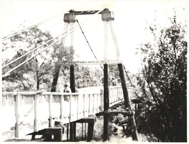
Photograph - Photograph (copy), Kanes Bridge, Studley Park, 195-1955
In 1928 a footbridge was erected to link Kew with the public golf course across the Yarra. The total cost of construction came to 250 pounds and the bridge became known as Kane's Bridge. During the 1934 floods the bridge was washed downstream, and was subsequently rebuilt. The present form of the bridge resembles the earlier bridge which crossed from the Yarra Bend Asylum to Kew, further upstream. (VHD)This work forms part of the collection assembled by the historian Dorothy Rogers, that was donated to the Kew Historical Society by her son John Rogers in 2015. The manuscripts, photographs, maps, and documents were sourced by her from both family and local collections or produced as references for her print publications. Many were directly used by Rogers in writing ‘Lovely Old Homes of Kew’ (1961) and 'A History of Kew' (1973), or the numerous articles on local history that she produced for suburban newspapers. Most of the photographs in the collection include detailed annotations in her hand. The Rogers Collection provides a comprehensive insight into the working habits of a historian in the 1960s and 1970s. Together it forms the largest privately-donated collection within the archives of the Kew Historical Society.A photographic copy of an older photograph of Kanes Bridge."Kanes Bridge"kanes bridge, yarra river, bridges - kew (vic.) -
 Kew Historical Society Inc
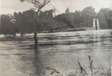
Photograph - Kane's Bridge on the Yarra River, December 1934
In 1928 a footbridge was erected to link Kew with the public golf course across the Yarra. The total cost of construction came to 250 pounds and the bridge became known as Kane's Bridge. During the 1934 floods the bridge was washed downstream, and was subsequently rebuilt. The present form of the bridge resembles the earlier bridge which crossed from the Yarra Bend Asylum to Kew, further upstream. (VHD)Original, black and white positive of Kane's Bridge in December 1934, when the 'great flood' of the Yarra caused the bridge's destruction. Inscribed verso: "Kane's Bridge Yarra in flood Dec 1934"river yarra, yarra -- kew (vic.), kanes bridge, 1934 floods -
 Kew Historical Society Inc
Photograph - Kane's Bridge destroyed by the 1934 Flood, 1934
In 1928 a footbridge was erected to link Kew with the public golf course across the Yarra. The total cost of construction came to 250 pounds and the bridge became known as Kane's Bridge. During the 1934 floods the bridge was washed downstream, and was subsequently rebuilt. The present form of the bridge resembles the earlier bridge which crossed from the Yarra Bend Asylum to Kew, further upstream. (VHD)Black and white positive print (identical to 2021.70 but with a different annotation) showing the destruction of Kane's Bridge in the floods of 1934. The Kodak paper would indicate a 1950s reprinting.Annotation verso: "Kane's Bridge in 1934 flood / Dec. 1934.kane's bridge, river yarra, yarra valley, 1934 floods -
 Greensborough Historical Society
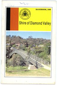
Book, Shire of Diamond Valley, Shire of Diamond Valley Handbook 1980, 1980_
Guide to services provided by Shire of Diamond Valley. The Shire of Diamond Valley was a Local Government Area located about 20 kilometres northeast of Melbourne. The shire covered an area of 74.38 square kilometres and existed from 1964 until 1994. Cover illustration of footbridge over the Plenty River at Flintoff Street. The span is 50 metres and cost $56,100 to build in 1978.Annual guide to services in Shire of Diamond Valley32 pages, col illus., maps. shire of diamond valley, greensborough, handbooks -
 Ringwood and District Historical Society
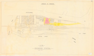
Plan, Borough of Ringwood - VR Ringwood Station - Circa 1930s
Technical drawing of Ringwood Railway Station features, surrounding streets and buildings including Cool Stores, Packing Shed, Coke Bin, Coal Box, Dam, Garage, Shops, ES&A Bank, Station Master's Residence, Drill Hall, Goods Shed, Signal Box, Passenger Platform, Footbridge, and Clock Tower at Warrandyte Road. Station entrance and traffic access areas shaded red and yellow.Scale: 1"=40' -
 Lakes Entrance Historical Society
Photograph - Kite Festival, 1/11/1995 12:00:00 AM
Princes Highway viewing Point Kalimna showing Bullock Island during the International Kite Festival. The vast expanse of dumped sand perfect for Kite Flying but not the environment covers a large area of the island Lakes Entrance Victoria. Also a colour photograph taken of banners and kites at the Foorbridge venue of the International Kite Festival number 04048.1Colour photograph taken from Princes Highway viewing Point Kalimna showing Bullock Island during the International Kite Festival. The vast expanse of dumped sand perfect for Kite Flying but not the environment covers a large area of the island Lakes Entrance Victoria. Also 2 colour photographs taken of banners and kites at the Footbridge venue of the International Kite Festival number 04048.1 and 04048.2 sports, kites, events -
 Eltham District Historical Society Inc
Photograph, Odyssey House Victoria, 28 Bonds Road, Lower Plenty, 6 March 1990
Odyssey House drug rehabilitation centre in Bonds Road, Lower Plenty is a distinctive landmark, especially when viewed from across the Yarra at Templestowe. It was built in the 1950’s as a seminary for the Blessed Sacrament Fathers. Because of the poor and circuitous road access, a suspension footbridge was built across the river. As well as providing easy access for the priests residents of Templestowe could attend services at the seminary. The bridge is now part of the Yarra Trails system.Colour photographlower plenty, bonds road, odyssey house -
 Melbourne Tram Museum
Pamphlet, The Met, "Now you've got the tickets how are you going to get there?", mid 1990s
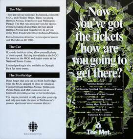
Pamphlet "Now you've got the tickets how are you going to get there?" published jointly by The Met and Sport and Recreation Victoria with a map of the major sporting venues in the city area and the Victorian Arts Centre. Published before the diversion of the Batman Ave tram line via Flinders St. Gives tips on parking, train/tram travel, and the MCG footbridge. The line was diverted via Flinders St on 6/6/1999 - see reference. yields information about the travelling to the major Melbourne sports venues.Pamphlet - 2 fold DL printed in colour with map.trams, tramways, the met, sporting venues, public transport, maps, batman ave, batman avenue -
 Kew Historical Society Inc
Print - Walmer Street Foot Bridge, 1901
Photographic print of the Walmer Street Bridge. The view of the Bridge is from the Abbotsford side of the Yarra. A section of pipe on the near side of the bridge is a remnant of the irrigation pipes that carried water from above Dight's falls to the Melbourne Botanic Gardens. The former bridge, constructed in 1896 was swept away in the 1901 Flood. It has two major brick piers while the remainder of the trestle supports are metal. The original photograph from which this copy was made was taken after 1901 as it shows the second bridge under construction. Houses in Young Street, Kew, can be seen on the far side of the river.Reverse: " Walmer St footbridge 1901 being repaired after flood / Constructed 1892 substantially renewed in 1901 and in 1928 / Rebuilt in 1977 by Kew Council aided by State funding. Won for designer Martin Aylard a New Zealand award presented by the timber Research & Development Assoc / Site of Simpsons Road passenger foot ferry". bridges - yarra river -- kew (vic.), walmer street bridge -- kew (vic.) -
 Bendigo Historical Society Inc.
Photograph - HARRY BIGGS COLLECTION: HIGH ST. BENDIGO, 1857
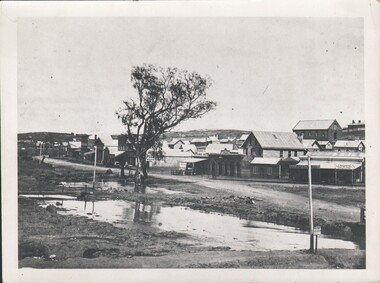
Harry Biggs Collection. Black & white photo of High St. Bendigo. Shop signs visible - T. Baldwin Hair Cutting, shaving shampooing; Burston's Colonial Boot Store, Royal Hotel, Britannia House. A sign post: 'Eadie & McIntyre Gold Office'. In foreground Bendigo Creek with a footbridge to the left. Two gnarled trees in centre of photo. Photo taken near View Point. Image taken in 1850's.place, building, commercial, harry biggs collection, high st. bendigo -
 Lakes Entrance Historical Society
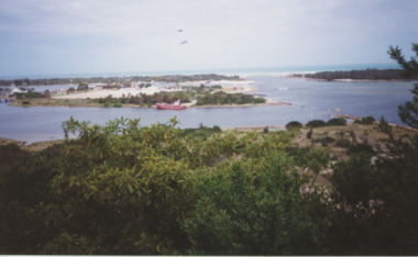
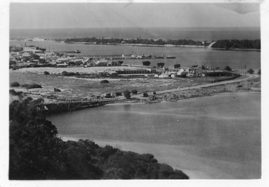
Postcard - Aerial view of Lakes Entrance, 1940c
Also 1 Black and White Photographic copy 12.5cmx17.5cm, fair condition P01154-2Black and White Photographic miniature postcard showing the southern abutment of the North Arm Bridge, town, including Club Hotel and garage, sand, hummocks and in distance, the footbridge across Cunninghame Arm. Workmens huts at bridge approach, motor car and truck parked westside of bridge approach. Boats in western boat harbour. Atlantic Ethyl sign behind Club Hotel, and tanks on tall tankstands. Lakes Entrance Victoriabridges, coast, hotels, boats and boating, fences, transport -
 Ballarat Tramway Museum
Photograph - View from Ballarat Railway Station footbridge, Ken McCarthy, 6-1-1951
The photo shows an SEC tram No. 20, crossing the railway level crossing in Lydiard St North from the Ballarat Railway station footbridge. Shows shelters and closed gates at the end of the platforms used to control passenger access. Victoria House in the background. A side entry or dogbox-type carriage is in platform No. 2. Noted the dog boxes at the end of platform 1 just before the gates. Dated 6-1-1951, photo by Ken Mcarthy. See also item 8896 for a similar photograph.Yields information Ballarat Railway Station and the level crossing.Black and white print with notes on rear."In ink on rear "#20 on Lydiard St xing Ballarat from station 6-1-51" and Ken McCarthy stamp with photo Number 761trams, tramways, lydiard st north, level crossing, railway station, ballarat railway station, tram 20 -
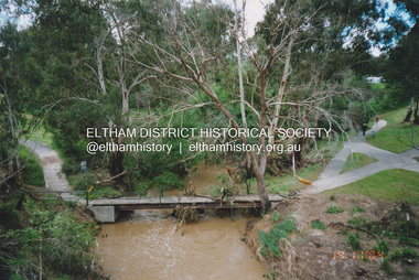
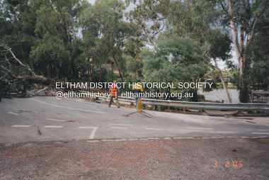 Eltham District Historical Society Inc
Photograph, Fay Bridge, Diamond Creek in flood, Eltham, 3 February 2005
Significant flood events occurred Nov-Dec 2004 and Jan-Feb 2005.fay bridge collection, bridge street bridge, diamond creek (creek), floods, floodwater, footbridge, main road bridge, susan street oval, diamond street, eltham -
![Newspaper clipping, Ode To My Suburb [Diamond Creek], 12/09/2012](/media/collectors/4f729f5697f83e03086015b8/items/52310c712162ef26c44f005e/item-media/52539b042162ef15c0b9aeb7/item-fit-380x285.jpg) Greensborough Historical Society
Greensborough Historical SocietyNewspaper clipping, Ode To My Suburb [Diamond Creek], 12/09/2012
The article describes the memories of the author growing up in Diamond Creek.The article features 8 photographs of sites around Diamond Creek.A one page multi coloured article from the Weekly Review of 12/09/12.Nildiamond creek, cemetary gates, netball court, swimming pool, windmill residence, footbridge, challenger st, a.d. ryans, st johns, 3089 -
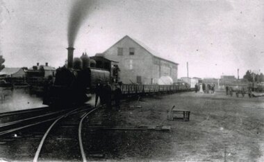 Otway Districts Historical Society
Photograph, Locomotive 8A and its mixed train at Colac Railway Station, c.1920, c.1920
Station facilities for the travelling public on the narrow gauge line at Colac Railway Station were non-existent for many years. Tickets were purchased from the broad gauge booking office and the travellers then had to walk with their luggage over the rough, potentially ankle-twisting, stone approaches, through the goods yard and wait in the open amongst the mud holes alongside the narrow gauge departure track. In 1922 a footbridge was erected over the broad gauge lines, and a passenger shelter and small goods shed were built on the departure track.B/W. At Colac Railway Station, an locomotive 8A with five NQR wagons, an NM livestock wagon and a NBDBD combined passenger and brake van destined for Beech Forest, with either the driver or the fireman peering out of the engine, three youths standing at the front of the engine, and a group of people, including a woman, standing near the livestock wagon. A multi-storied shed and two houses are in the background. 179mm x 280mm picture.colac; railway; narrow gauge; na locomotive; -
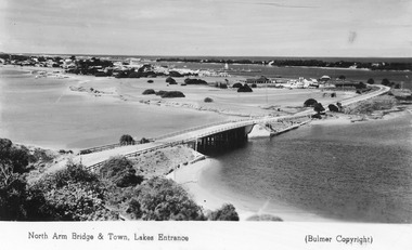 Lakes Entrance Historical Society
Postcard - Lakes Entrance from Jemmys Point, Bulmer H D, 1950c
Township of Lakes Entrance from Jemmys PointColour tinted postcard of township showing bridge across North Arm; town buildings including Club Hotel, Methodist Church, Maranui Guest House; tower of Central Hotel; jetties in Cunninghame Arm, and sand dunes. Caravan parked beside concrete brick constructed toilet block opposite road to Bullock Island. Footbridge across Cunninghame Arm in distance, also lookout tower on Esplanade, and Life Saving tower over hummocks. Lakes Entrance VictoriaNorth Arm Bridge and Town, Lakes Entrancetownship, jetties, guesthouses, islands, hotels -
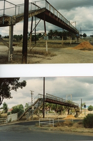 Stawell Historical Society Inc
Photograph, Railway Step Bridge Stawell 1991 -- 4 Photos 2 on one page & 2 Individual Photos
Series of four photos of Railway Step Bridge Stawell 1991Four (4) Colour Photographs, two on one page and 2 individual Photographs.The Two photographs one showing a footbridge in the distance with two cement pipes in front, and a pile of soil further back. A Truck is parked under the bridge. Buildings are in the distance on the lsft side. The Lower photograph is showing the bridge almost dismantled with the surfces of the bridge being held by two cranes with a person on the brdge. The other two photgraphs show the bridge from the groundlooking across the railway tracks one is a clsoe up of the bridge. On the rear of the tow Individual Photographs 224-2a on the top from the left Stawell Old Railway Bridge Bottom left corner ST1-2 224-2b From top left Stawell Old Railway bridge 1991. Bottom left ST1-4stawell, railways -
 Southern Sherbrooke Historical Society Inc.
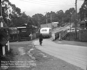
Photograph, Belgrave Railway Bridge, 1947
Belgrave railway bridge looking towards Bayview Road from Terrys Ave, 1947. It shows a bus crossing the bridge onto (now) Belgrave-Gembrook Road, followed by a male cyclist wearing a dark overcoat and bowler hat. A man wearing a homburg hat is crossing the footbridge beside the main bridge towards the main street. There is a pale van parked (or driving past) a dairy on the corner of Bayview Rd and Belgrave-Gembrook Road. A brick toilet block is shown with a sign saying 'MEN' on a nearby lamp post. -
 Eltham District Historical Society Inc
Photograph, Peter Pidgeon, Manna Gum, Main Road Bridge, Eltham South, 8 Sep. 2021
This significant tree located near the Main Road Bridge and Diamond Creek Trail footbridge over the Diamond Creek at Eltham dates back to the early 1900s. The original timber bridge over the Diamond Creek was built around 1840. It was destroyed by floodwaters in October 1923. A temporary bridge was rigged up but further damaged in April 1924. A new concrete bridge was built and opened in October 1926. The bridge decking was widened along with Main Road to Dalton Street by the Road Construction Authority in 1984., The uygraded bridge was opened in October 1984, 78 years after its original opening.These trees are not only significant for the natural environment but also present a navigational beacon back in time as the environmental landscape is developed around them.Born Digitaleltham south, main road bridge, manna gum, significant tree, diamond creek trail -
 Eltham District Historical Society Inc
Photograph, Peter Pidgeon, Manna Gum, Main Road Bridge, Eltham South, 8 Sep. 2021
This significant tree located near the Main Road Bridge and Diamond Creek Trail footbridge over the Diamond Creek at Eltham dates back to around 1870-1880. The original timber bridge over the Diamond Creek was built around 1840. It was destroyed by floodwaters in October 1923. A temporary bridge was rigged up but further damaged in April 1924. A new concrete bridge was built and opened in October 1926. The bridge decking was widened along with Main Road to Dalton Street by the Road Construction Authority in 1984., The uygraded bridge was opened in October 1984, 78 years after its original opening.These trees are not only significant for the natural environment but also present a navigational beacon back in time as the environmental landscape is developed around them.Born Digitaleltham south, main road bridge, manna gum, significant tree, diamond creek trail -
 Eltham District Historical Society Inc
Photograph, Peter Pidgeon, Manna Gum, Main Road Bridge, Eltham South, 8 Sep. 2021
This significant tree located near the Main Road Bridge and Diamond Creek Trail footbridge over the Diamond Creek at Eltham dates back to around 1870-1880. The original timber bridge over the Diamond Creek was built around 1840. It was destroyed by floodwaters in October 1923. A temporary bridge was rigged up but further damaged in April 1924. A new concrete bridge was built and opened in October 1926. The bridge decking was widened along with Main Road to Dalton Street by the Road Construction Authority in 1984., The upgraded bridge was opened in October 1984, 78 years after its original opening.These trees are not only significant for the natural environment but also present a navigational beacon back in time as the environmental landscape is developed around them.Born Digitaleltham south, main road bridge, manna gum, significant tree, diamond creek trail -
 Eltham District Historical Society Inc
Photograph, Peter Pidgeon, Manna Gum, Main Road Bridge, Eltham South, 8 Sep. 2021
This significant tree located near the Main Road Bridge and Diamond Creek Trail footbridge over the Diamond Creek at Eltham dates back to the early 1900s. The original timber bridge over the Diamond Creek was built around 1840. It was destroyed by floodwaters in October 1923. A temporary bridge was rigged up but further damaged in April 1924. A new concrete bridge was built and opened in October 1926. The bridge decking was widened along with Main Road to Dalton Street by the Road Construction Authority in 1984., The uygraded bridge was opened in October 1984, 78 years after its original opening.These trees are not only significant for the natural environment but also present a navigational beacon back in time as the environmental landscape is developed around them.Born Digitaleltham south, main road bridge, manna gum, significant tree, diamond creek trail -
 Eltham District Historical Society Inc
Photograph, Fay Bridge, Flood damage to footbridges over the Diamond Creek, Eltham, 14 November 2004
Significant flood events occurred Nov-Dec 2004 and Jan-Feb 2005.fay bridge collection, 2004-11-14, bridge street bridge, diamond creek (creek), diamond street bridge, flood damage, floods, floodwater, footbridge, main road bridge, susan street oval, withers way -
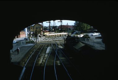 Ballarat Tramway Museum
Slide - 35mm slide/s, Ben Parle, 8/04/1958 12:00:00 AM
Kodachrome Transparency - 35mm slide - cardboard mount, with one side with red border and words "Kodachrome Transparency / Processed by Kodak" top and bottom. Photo taken by Ben Parle 8/4/1958. Has slide No. "16" stamped in red in top corner. Photo of Ballarat No. 42 crossing the rail crossing, Lydiard St. North, Ballarat Railway Station. Taken from the footbridge within the station roof. A K class hauled goods is waiting on platform No. 2 to leave the station. Has the signal gantry and "B" signal box in the background. "Lydiard St Ballarat 8-4-58"tramways, trams, lydiard st, railway, level crossings, ballarat railway station, tram 42 -
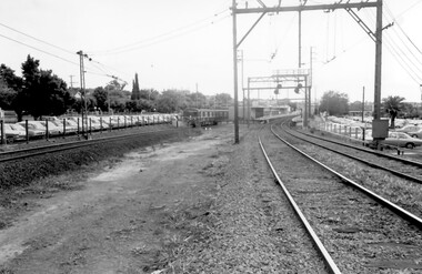 Surrey Hills Historical Society Collection
Photograph, Surrey Hills Station and car park
There are 3 tracks; the third track was built in 1971, which gives an approximate date for the photo. At this time the original station buildings were demolished and replaced by buildings constructed from concrete bricks and a second subway replaced the overhead footbridge. According to Roderick Smith, a local railway enthusiast, originally there had been 3 railway houses at the Mont Albert end of the northern car park. These were demolished to extend the car park. Certainly 8 Bedford Avenue, built as the station master's house was demolished at this time. The palm tree had been planted in the station master's front garden and was retained in a small garden bed within the car park. A black and white photograph of a station with cars parked on both sides of the 3 tracks. A Harris train is departing the station heading towards Mont Albert. A palm tree is prominent in the station car park to the north.1971, surrey hills station, railway stations, car parks, public transport, trains, railway lines, palm tree -
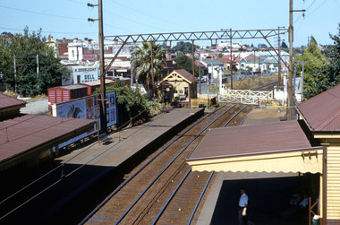 Surrey Hills Historical Society Collection
Work on paper - Digital photograph, George L Coop, Surrey Hills railway station c1958, c1958
The donor George Lister Coop was about 21 years of age when he took this photo. It is one of a small series of photos donated by him that relate to Mont Albert and Surrey Hills stations. He has always had an interest in railways and there are other examples of his documentation of railway history in other collections contributing to this database. R J Mercer was the butcher at 112 Union Road. This property has a long history of being a butcher's shop beginning from c1904. He took over from Edward Lloyd in 1951. Spotless Dry Cleaners were at 104 Union Road.This is an important photo as there are few known colour images of the station prior to the installation of the third line in the early 1970s, which resulted in the demolition of the station built in 1883. It is also significant as a record of the housing along the south side of Stirling Crescent which was later replaced by light industry.A digital colour photo of Surrey Hills railway station taken from the overhead pedestrian footbridge looking towards Canterbury. Both tracks and the verandas on either side of the line can be seen, as can the railway gates in the open position and the signal box, beside which is a large palm tree. A section of red goods vans are positioned in the adjacent goods yard. Some of the businesses and advertising hoardings in Union Road can be seen in the background. These include A Doubleday (real estate agents), R J Mer..., grocer, baker, Spotless Dry Cleaning, Robur tea and Lipton tea (part of only). A number of the Edwardian houses along the south side of Stirling Crescent are also seen.george l coop, surrey hills railway station, goods yard, real estate agent, a doubleday, grocer, baker, union road, stirling crescent, spotless dry cleaning, r j mercer, butcher -
 Flagstaff Hill Maritime Museum and Village
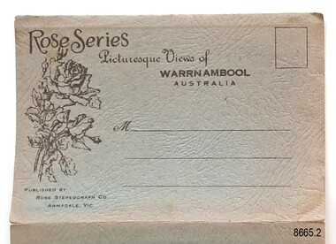
Postcard - Postcard Folder, scenes, George Rose, Rose Stereographic Company, Rose Series, Picturesque Views of Warrnambool Australia, 1880-1942
GEORGE ROSE 1861-1942: - George Rose was a well-known Victorian photographer, famous for his late 19th and early 20th century photography. He was born in Clunes, Victoria, and was in his 20th year when he founded Rose Stereograph Company in 1880. He took the opportunity of a popular trend of the times to produce stereographs, pairs of almost duplicate photographs that appeared in 3D when viewed in a handheld stereo viewer. By the 1920s, these lost their popularity, so he used his photographic skills to produce cards and postcards of scenes and people. The twelve photographs in the Rose postcard folders include locations connected to other items in our Collection, including the Valentine postcard folder in this set. The photographs are titled: - . The Avenue and War Memorial. Warrnambool. Vic. . The Blow-hole. Thunder Point. Warrnambool. Vic. . Botanical Gardens. Warrnambool. Vic. . Eagle Rock. Warrnambool. Vic. . The New Concrete Bridge and Breakwater. Warrnambool. Vic. . Liebig Street. Warrnambool. Vic. . Looking to Thunder Point. Warrnambool. Vic. . The Beach. Warrnambool. Vic. . Hopkins Falls. Warrnambool. Vic. . Shelly Beach. Warrnambool. Vic. . The Mouth of the Hopkins River. Warrnambool. Vic. . Panorama of Warrnambool, Vic. [Kepler Street towards Presbyterian Church on Spence St] This postcard folder shows scenes and places of interest in and around Warrnambool. The George Rose postcard folders in this set were produced in Victoria and include pictures taken by the renowned photographer between 1880 and 1942. Other postcards in our collection have photographs of the same or similar locations at different periods in time. Each postcard records a moment in history and is significant as a way to compare and show the changes in the local environment and community, building a story of the local history. The images record changes in the coastline, land, bay, buildings and other structures, roads, transportation and even the fashions of the times. This copy folder is one of a set of three. This folder has a green-grey textured rectangular card cover with a sketch of a rose on the front. The cover also contains the name of the postcard series, the location of the series' focus, the producer's details, and lines for adding an address. The folded cover contains a long, concertinaed page with six titled photographs on each side, totalling twelve. The folder contains scenes from Warrnambool and nearby popular areas, including Lady Bay, the Port of Warrnambool, the Warrnambool Breakwater, the Viaduct, the Merri River Footbridge, the Hopkins River Mouth, and Proudfoot’s and the Fanny Nelson/Flett boathouses. The cover has a sketch of a rose and inscriptions. The lithograph photographs were taken between 1880 and 1942 by well-known Victorian photographer George Rose, Rose Stereograph Company of Armadale, Victoria.Image: [Rose with rosebud and leaves] Printed: "Rose Series / Picturesque Views of / WARRNAMBOOL / AUSTRALIA" "PUBLISHED BY / ROSE STEREOGRAPH CO / ARMADALE. VIC."flagstaff hill maritime museum and village, great ocean road, shipwreck coast, warrnambool, flagstaff hill, flagstaff hill maritime museum, flagstaff hill maritime village, warramble, postcard, postcard folder, warrnambool scenes, picturesque views of warrnambool, lady bay, port of warrnambool, breakwater, warrnambool breakwater, viaduct, merri river footbridge, merri river suspension bridge, suspension footbridge, merri river mouth, hopkins river mouth, proudfoot's, fanny nelson, nelson's boatsheds, nelson's boathouse, boathouse, hopkins river boathouses, flett's boathouse, flett, george rose, image of a rose, rose series, rose stereograph co, rose stereographic company, lighograph, armadale victoria, lady bay beach, beach scene, lower light, concrete footbridge, 1922 footbridge, viaduct road, rose postcard, new concrete bridge, 1945, 1890, 1922, small footbridge, 1872 footbridge, 1872, merri river estuary, stingray bay, postcards, green-grey postcard folder, shipwrecked coast, maritime museum, souvenir, warrnambool local scenes, photography, local history, tourism, photographs, visitors, travel, scenes, mid-20th century, 1940s, 1950s, concertina fold, z-fold, 1880s, collection, correspondence, rose stereograph co armadale, victorian photographer, soldiers’ memorial, hopkins river, the cliffs at shelly beach, the road to sandy beach, pier, botanic gardens, post office, municipal buildings, merri river, proudfoot’s