Showing 255 items
matching gold mining site
-
 Bendigo Historical Society Inc.
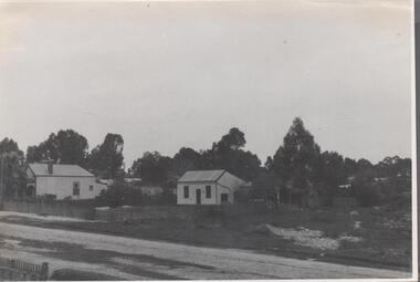
Photograph - Nell Gwynne Gold Mine site, 1934
The Nell Gwynne mine site was within the Spring Gully Water Reserve, north west of the reservoir near Diamond Hill Road. An abridged prospectus for the Nell Gwynne (B.M.L.) No Liability, was published in the Sun News Pictorial on 7th June 1934, page 26 (Advertising).https://trove.nla.gov.au/newspaper/article/277316940?searchTerm=napoleon%20bmlSignificant to mining history of Bendigo.Black and white photograph of two weatherboard houses in bush setting. Gravel road in foreground. Written in pencil on back of photograph in pencil: 'Nell Gwynne 25.9.34'nell gwynne gold mine -
 Bendigo Historical Society Inc.
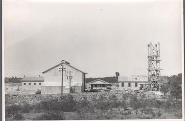
Photograph - Carshalton Headframe, 1935
Significant to mining history of Bendigo.Black and white photograph : image shows metal headframe at Carshalton mine site. Mine sheds in background. Written in pencil on back of photograph in pencil: 'Carshalton headframe 14.6.35'carshalton gold mine, diesel compressor, winder -
 Bendigo Historical Society Inc.
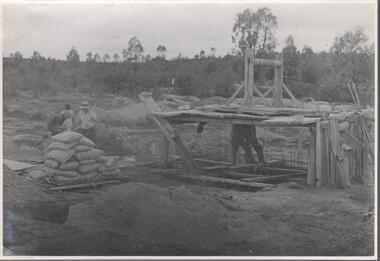
Photograph - Carshalton Gold Mine site, 1935
Significant to mining history of Bendigo.Black and white photograph : image shows Carshalton gold mine site with shaft and improvised winch on platform standing over shaft. Bags of (presumably) cement on left hand side, two men standing on framing over shaft, three on left hand side of bags of cement. Written in pencil on back of photograph in pencil: 'Pouring concrete collar Carshalton'carshalton gold mine, cement, concrete collar, shaft -
 Bendigo Historical Society Inc.
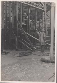
Photograph - Carshalton Gold Mine, 1935
Significant to mining history of Bendigo.Black and white photograph : image shows Carshalton gold mine site; mine sheds under construction. Written in pencil on back of photograph in pencil: 'Carshalton 11.12.34'carshalton gold mine -
 Bendigo Historical Society Inc.
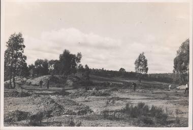
Photograph - Napoleon Gold Mine, 1935
Significant to mining history of Bendigo.Black and white photograph : Napoleon Gold Mine main shaft 1934. Image shows landscape view, some earth workings on site. Five men walking on different parts of site. Trees in background. Written in pencil on back of photograph in pencil: 'Napoleon main shaft site 23/8/34''napoleon gold mine -
 Bendigo Historical Society Inc.
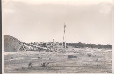
Photograph - Napoleon Gold Mine, 1935
Significant to mining history of Bendigo.Black and white photograph : landscape view of Old Napoleon gold mine site showing the early stages of the development of the mine. Mullock heap on left hand side with inclined temporary trestleway leaning on side of heap. Written in pencil on back of photograph in pencil: 'Old Napoleon 6.12.34''napoleon gold mine, mullock -
 Clunes Museum
Photograph, C. NETTLETON, PORT PHILLIP MINE, APPROX. 1866 OR 1867
PHOTOGRAPH OF PORT PHILLIP MINE ABOUT 186 OR 1867. NOTE COVERED FLUE TO BRICK CHIMNEY TO RIGHT. IN 1966 THERE WERE A FEW BRICKS AT THE SIGHT OF THE CHIMNEY AND A SHALLOW TRENCH ALONG THE LINE OF THE FLUE. SITE OF PRESENT GOLD MONUMENT IS JUST TO RIGHT OF POPPET HEAD SHOWN ON HILL. WOOD PILE OUTSIDE BUILDING TROLLEY LINES ETC.SEPIA PHOTOGRAPH OF PORT PHILLIP AND COLONIAL GOLD MINING COMPANY, CLUNES. PHOTOGRAPH TAKEN FROM CAMP PARADE, LOOKING NORTH. GENERAL VIEW OF MINE AND WORKS IN 1866 OR 1867.photographs, mining, port phillip and colonial gold mining company -
 Bendigo Historical Society Inc.
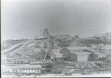
Photograph - Napoleon Reef Gold Mine Battery Site, 1936
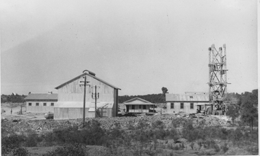
The Napoleon (BML) gold mine (1932) was located near McDougall Road, Golden Gully, between Martin and Hattam Street. It had a depth of 921 feet. It was one of the latest and most lavish of Bendigo's mines. Plant and equipment were electrically driven. The four-compartment shaft, extra large by goldfield's standards, measured 17 feet 6 inches by 5 feet 2 inches and was cement lined below 900 feet instead of being red gum boxed as was the usual practice. The workshop was equipped to carry out all repairs for the equally lavish BML mines on the Nell Gwynne and Carshalton reefs. (The Gold Mines of Bendigo, Book 2, Arthur Victor Palmer) 'Napoleon BML Mines No Liability have issued a report for the fortnight ended September 5, where it states that the development scheme has been formulated and necessary equipment is being ordered. The Napoleon main shaft, (about 1700 feet south of the old Napoleon shaft) will be a four compartment shaft (17ft 6 inches by ft 2 inches inside the timber). aLevels will be opened at approximately 100 ft vertical intervals and cross-cuts extended approximately 125 ft each side of centre country to explore a cross-section across the anticline opposite to the shaft. At every fifth level, main drives will be extended north to connect with the old Napoleon shaft and south approximately 1800 ft. At the latter point, another cross-section of the anticline will be explored by rising and cross-cutting. The old Napoleon will be unwatered and on the 500ft and 1000 ft levels main drives will be driven to connect with main levels from the Napoleon main shaft to the south as well as being driven north 1800 ft where another cross-section of the anticline will be explored. Cross-sections further north and south may be developed as desired and also at intermediate points if necessary. Clearing and grading of the main shaft site are now in progress and the erection of the office and store building is proceeding. The design of engine room, change house and machine shops is now in hand and erection will proceed as soon as working plans and specifications are prepared.' The main shaft has been commenced at 3ft and advanced 10 ft. to 13 ft. https://trove.nla.gov.au/newspaper/article/10975478?searchTerm=napoleon%20bml (The Argus, 8th. September 1934, 'Mining' page 18) Significant to mining history of Bendigo.Black and white photograph of a stamper head being lowered into position on the battery site of the Napoleon Reef Gold Mine. A wooden gantry supports the battery head as it being lowered. Three large concrete foundations are visible in immediate background, two of which have stampers already in position, the third stamper is being lowered onto the final foundation. In immediate foreground, 'boxing' is erected for future concrete pours. napoleon gold mine, napoleon reef gold mine -
 Bendigo Historical Society Inc.
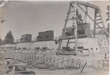
Photograph - Nell Gwynne (BML) Gold Mine, 1935
Significant to mining history of Bendigo.Black and white photograph : Nell Gwynne mine site. Corrugated iron mine buildings, head frame on right hand side of image, erection almost complete. Power lines in foreground. Written in pencil on back of photograph in black pen: ' Nell Gwynne '7.2.35 'carshalton gold mine, diesel compressor, winder, trestle way -
 The Beechworth Burke Museum
Photograph
This image is a reproduction of an 1899 original depicting the 'Williams Good Luck Mine' on the Mopoke Reef (also called 'Morepork Gully') in the Dingle Ranges, approximately three miles from Beechworth. A large opening to a mine can be seen behind the men in the photograph, with a wheeled cart on a track leading to the men's position, where the soil and rocks have been hauled away. This photograph interestingly contains dogs alongside the miners. While dogs have been recorded as deterrents to thieves in the Victorian goldfields, these dogs appear as companions to these men. Following the discovery of gold at Beechworth in 1852, rushes quickly followed at surrounding creeks and gullies in the district. In the late nineteenth and early twentieth centuries, small syndicates of miners continued to work old or abandoned quartz reefs, often persisting without the assistance of heavy machinery to remove the large amounts of rock, in order to obtain yields at ever greater depths. The group of miners in this photograph are Mr. Roger Williams and Sons, who revived operations at the ‘Old Good Luck’ mine on the Mopoke Reef in the Dingle Range near Beechworth around 1892, working the site for more than two decades. An emigrant from Cornwall with experience in the tin mining industry, 19 year old Roger Williams senior sailed to New Zealand in 1840, then to Australia where he spent time in the Bendigo Gold Fields before settling in Beechworth in the early 1860s. Mr Williams senior worked on various mining activities in the district, including the Rocky Mountain Tunnel project. Conversant with the character of gold-bearing reefs in the area, the syndicate dug an eight hundred foot tunnel, digging down as far down as two hundred feet with little capital save their labour, to connect and provide better working access to the mass of reefs and veins in the vicinity. Progress was hampered by poor air quality charged with fumes from dynamite and large quantities of rock had to be crushed to obtain payable yields. The Victorian Goldfields are filled with ruins and remnants of the area's rich mining history, ranging from small alluvial diggings to the remains of huge mining companies. Site names often changed several times throughout the nineteenth and twentieth centuries. Some sites were abandoned and forgotten, others were worked continuously over many decades. The names of mines were often repeated at different locations throughout the Victorian Goldfields. For example, there is a Mopoke Gully heritage mine near Fryers Creek, Victoria. 'Mopoke' is a common onomatopoeic name for Morepork and Australian Boobook owls.This image has historical, social and research significance for patterns of emigration during of the Victorian Gold Rush, and the historical, social and environmental impacts of mining at Beechworth at the turn of the nineteenth and twentieth centuries. As gold became scarce and government support and large company investment waned, poor hard-working miners laboured intensively to make a living through periods of high unemployment. This image can be compared and studied alongside other historical mining photographs and objects in the Burke Museum Collection. It has potential to improve our understanding of miners working conditions and the shifting character of mining in the Beechworth district.Sepia coloured rectangular photograph printed on gloss photographic paper mounted on card. Obverse: Williams/ Good/ Luck Reverse: A02498/ 1997. 2498/ Good Luck/ Mine/ 1899/ Mopoke. burke museum, beechworth museum, beechworth, gold fields, gold rush, victorian gold rush, gold ming history, colonial australia, australian gold rushes, mining technology, beechworth historic district, indigo gold trail, migration, indigo shire, good luck gold mine, victorian goldfields, mining syndicates, gold fever, quartz-mining, small-scale mining, old good luck mine, mopoke gully, quartz reefs beechworth -
 The Beechworth Burke Museum
Photograph
This image is a reproduction of an 1899 original depicting the 'Williams Good Luck Mine' on the Mopoke Reef (also called 'Morepork Gully') in the Dingle Ranges, approximately three miles from Beechworth. The foreground of the image is littered with piles of smashed rock and detritus, known as ‘mullock’, beside a reinforced mine shaft, a vertical access passageway allowing miners to enter the mine and haul ore out using lifting technology such as a poppet heads, whims or windlasses. A group of miners and a dog appear close to an open-sided miner’s hut. Following the discovery of gold at Beechworth in 1852, rushes quickly followed at surrounding creeks and gullies in the district. In the late nineteenth and early twentieth centuries, small syndicates of miners continued to work old or abandoned quartz reefs, often persisting without the assistance of heavy machinery to remove the large amounts of rock, in order to obtain yields at ever greater depths. The group of miners in this photograph are Mr. Roger Williams and Sons, who revived operations at the ‘Old Good Luck’ mine on the Mopoke Reef in the Dingle Range near Beechworth around 1892, working the site for more than two decades. An emigrant from Cornwall with experience in the tin mining industry, 19 year old Roger Williams senior sailed to New Zealand in 1840, then to Australia where he spent time in the Bendigo Gold Fields before settling in Beechworth in the early 1860s. Mr Williams senior worked on various mining activities in the district, including the Rocky Mountain Tunnel project. Conversant with the character of gold-bearing reefs in the area, the syndicate dug an eight hundred foot tunnel, digging down as far down as two hundred feet with little capital save their labour, to connect and provide better working access to the mass of reefs and veins in the vicinity. Progress was hampered by poor air quality charged with fumes from dynamite and large quantities of rock had to be crushed to obtain payable yields. The Victorian Goldfields are filled with ruins and remnants of the area's rich mining history, ranging from small alluvial diggings to the remains of huge mining companies. Site names often changed several times throughout the nineteenth and twentieth centuries. Some sites were abandoned and forgotten, others were worked continuously over many decades. The names of mines were often repeated at different locations throughout the Victorian Goldfields. For example, there is a Mopoke Gully heritage mine near Fryers Creek, Victoria. 'Mopoke' is a common onomatopoeic name for Morepork and Australian Boobook owls.This image has historical, social and research significance for patterns of emigration during of the Victorian Gold Rush, and the historical, social and environmental impacts of mining at Beechworth at the turn of the nineteenth and twentieth centuries. As gold became scarce and government support and large company investment waned, poor hard-working miners laboured intensively to make a living through periods of high unemployment. This image can be compared and studied alongside other historical mining photographs and objects in the Burke Museum Collection. It has potential to improve our understanding of miners working conditions and the shifting character of mining in the Beechworth district.Sepia coloured rectangular photograph printed on gloss photographic paper mounted on card.Obverse: Reverse: A02497/ 1997.2497/ 'Good/ Luck/ Mine'/ Morepork/ Gully/ Mrs Joyce/ Bright/ Tunnel/ 800 ft/ 1899. burke museum, beechworth museum, beechworth, gold fields, gold rush, victorian gold rush, gold ming history, colonial australia, australian gold rushes, mining technology, beechworth historic district, indigo gold trail, migration, indigo shire, good luck gold mine, victorian goldfields, mining syndicates, gold fever, quartz-mining, small-scale mining, old good luck mine, mopoke gully, quartz reefs beechworth -
 Lakes Entrance Historical Society
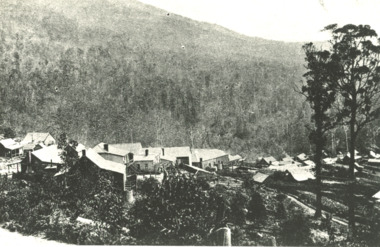
Photograph - Sunnyside, Mt Wills, Omeo Victoria, 1907 c
Black and white photograph of the township of Sunnyside which came into existence after gold was discovered at Mt Wills north of Omeo Victoriahistoric sites, mines and mining -
 Bendigo Historical Society Inc.
Newspaper - VICTORIA HILL - SITE FOR MINE MUSEUM
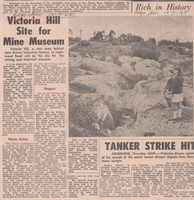
Newspaper article and photo from the Bendigo Advertiser dated 12/7/68. Article mentions Victoria Hill, behind John Brown Industries Factory, will be the site for the mining and historical museum. Photo shows two visitors looking at the open cut area of Victoria Hill.newspaper, bendigo advertiser, victoria hill, site for mine museum, john brown industries, bendigo city council, bendigo and district association, cr t r flood, victoria quartz gold mine, lansell's 180 mine, theodore ballerstedt, mr george lansell, heather champness, shirley leersen -
 Clunes Museum
Photograph, CIRCA 1860
COLLAGE - CLUNES IN THE 1860's SIX REPRODUCED BLACK AND WHITE AND COLOURED PHOTOGRAPHS MOUNTED IN WOODEN FRAME WITH BOLD EMBOSSED TRIM. CRITERION QUARTZ MINING COMPANY, PORT PHILIP & COLONIAL GOLD MINING COMPANY, VICTORIA QUARTZ MINING COMPANY. VIEW OF CAMP HILL , VIEW OF PORT PHILIP MINE SIGHT, VIEW OF THE LEVEL SITE OF BATTERY SEEN ON THE SITE ALONG STATION FLAT ROAD.local history, photographs, mining and township -
 Bendigo Historical Society Inc.
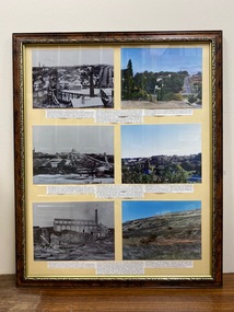
Photograph - Victoria Hill, Bendigo, 1973
Gold was discovered on Victoria Hill in 1854 and by 1861, 1,200,000 ounces of gold had been extracted from the site. The first claim was bought for 80 pounds by Prussian immigrant Christopher Ballerstedt and his son Theodore. Christopher Ballerstedt was nicknamed the "Father of the Hill" and was the first to prove that gold reefs extended below the surface. His 200-foot plus mine shafts yielded quartz rich with gold, inspired other miners, and were instrumental in Bendigo becoming the world's deepest and richest goldfield. The site still features relics of nineteenth century mining including quartz crushing machinery and the foundations of George Lansell’s 180 mine. These features are characteristic of Bendigo’s mining history and represent two prominent nineteenth century miners, Christopher Ballerstedt and George Lansell, who held important roles in the development of Bendigo. Victoria Hill Quartz Gold Mines are registered as a site of significance. The site is of historical, archaeological and scientific importance to Victoria. The mines represent the symbolic heart of Bendigo’s gold mining history and the importance that mining played in wealth creation and the development of Victoria. The diggings reserve is accessed from the rear of Albert Richardson Reserve located at 40-56 Marong Road, Ironbark. The site has steep and unformed paths and is closed to the public at dusk. It is important to stay to the paths to avoid the diggings. Interpretive signs help visitors to appreciate the importance of the site and the remaining relics of Bendigo’s mining history.Victoria Hill Ironbark, Bendigo. Photos of the poppet head, sand heap, tailings, shafts and tunnels. Before development into a tourist attraction.history, bendigo, victoria hill, ironbark, diggings