Showing 1833 items
matching inches
-
 Glenelg Shire Council Cultural Collection
Tool - Tools, n.d
Port of Portland CollectionBack: Wrench driver: 'SIDCHROME' -
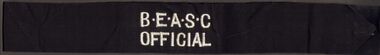 Bendigo Historical Society Inc.
Clothing - BERT GRAHAM COLLECTION: B.E.A.S.C. OFFICIAL ARM BAND
Object, Bert Graham Collection, Bendigo East Amateur Swimming Club Official arm band, Black material with white lettering on it, 30 inches X 2 inches.bendigo, clubs, victorian amateur swimming assoc.. -
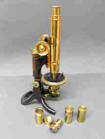 Federation University Historical Collection
Instrument - Scientific Object, J. Swift and Son, Petrographic Microscope
Boxed optical microscope, equipped with the following accessories: 1. Two ocular lenses, one with crosschain graticule 2. 6 objective lenses; AA, aa, a, 1/4 inch, 1/16 inch, 1 inch - cartridge only, 3/5 - lens without cartridges, Jictable frameScratched on top of right side front leg 'CM'. microscope, j. swift and son, scientific instruments -
The Ed Muirhead Physics Museum
Length Standards, NPL Certified, Archives
Certificate of Examination for #64 of one 6 inch glass scale, one 6 inch steel scale, and one 6 inch end gauge for Professor Lyle. 3 page document (copy) from National Physical Laboratory, Teddington. Paper held together with pin. (See also #63) -
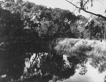 Eltham District Historical Society Inc
Photograph, George W. Bell, Peck's Pool, Eltham, c.1955, 1955c
Also known as Peck's Dam, it is today situated in the Pedersen Way Reserve, MontmorencyBlack and white photographic print (8 x 10 inch)On reverse - "Pecks Pool Eltham. Geo. W. Bell"eltham, george w. bell collection, houses, montmorency, peck's dam, peck's pool, pedersen way reserve -
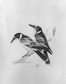 Eltham District Historical Society Inc
Photograph, Grey Butcher Birds - Margo Pederson, 1971
Reproduced page 135 of Pioneers & Painters, edited by Alan Marshall (1971) Source: Mrs Margo PedersonThis photo forms part of a collection of photographs gathered by the Shire of Eltham for their centenary project book,"Pioneers and Painters: 100 years of the Shire of Eltham" by Alan Marshall (1971). The collection of over 500 images is held in partnership between Eltham District Historical Society and Yarra Plenty Regional Library (Eltham Library) and is now formally known as the 'The Shire of Eltham Pioneers Photograph Collection.' It is significant in being the first community sourced collection representing the places and people of the Shire's first one hundred years.4 x 5 inch black and white negative (1) artist, pioneers and painters, sepp, shire of eltham pioneers photograph collection, margo pederson -
 Waverley RSL Sub Branch
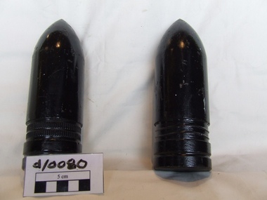
Shells
World War I artillery shells2 2 inch shells steel with black preserving paintnil -
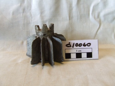 Waverley RSL Sub Branch
Tail fin candlestick
Exploded mortar tail fin used as a candle stick during Korean warAlloy metal tail fin from a 3 inch motar -
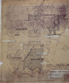
 Greensborough Historical Society
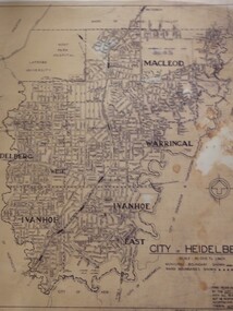
Map, City of Heidelberg: Municipal and Ward boundaries, 1967c
This map of the City of Heidelberg was issued subsequent to the separation of Heidelberg's North Ward to become the Shire of Diamond ValleyBlack on waxed paper. Scale: 20 chs to 1 inchG M Hutchins. 50c.city of heidelberg, heidelberg -
 Federation University Historical Collection
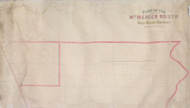
Plan, Plan of the Mount Mercer South Gold Mining Company
This plan is associated with former Ballarat School of Mines Student Richard Squire (1875-1876). Gift of the Squire FamilyPaper on linen. Handcoloured. Scale of 150 feet to one inch.mount mercer, gold mining, gold, mining -
Federation University Historical Collection
Domestic object - Object, Candle Mould
Metal candle mould for 6 x 9 inch candlescandle mould -
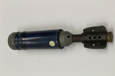 Dandenong/Cranbourne RSL Sub Branch
British Projectile, Circa 1940s
British Projectile - 2 inch illumination MK 2/1.2 in M. Illum. Mk 2/1. -
Ballarat RSL Sub-Branch Inc.
Photographs x 22
This object relates to Sylvester Walton WAKELING. He was born on 16/10/1904 in Ballarat, VIC. Sylvester Walton served in the ARMY (VX39764) enlisting on, 17/02/1941 in Albert Park, VIC before being killed during service with the 2/21 AUS INF BATTN as a Army Non-Commissioned Private (PTE) on 27/06/1945. Sylvester Walton WAKELING was a prisoner of war. His next of kin is E GLANFIELD.Black & White 3x4 inch New Guinea & Middle Eastsecond world war (ww2), 1939 - 1945, photo/pictures, ballarat rsl, ballarat -
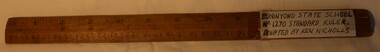 Buninyong Visitor Information Centre
Equipment - Ruler, Standard school ruler
Used by Ken Nicholls at the Buninyong State School around the 1950s.Twelve-inch wooden ruler with measurements imprinted on front and back.Measurement markings imprinted on both sides.measurement, education, buninyong primary school -
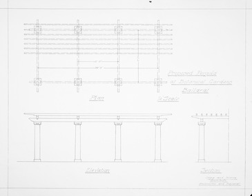 Friends of Ballarat Botanical Gardens History Group
Plan - Proposed Pergola Ballarat Botanical Gardens; Clegg and Morris Architects, Melbourne and Ballarat, Proposed Pergola Ballarat Botanical Gardens
HistoricPhotocopy of proposed pergola structure. 1/4 inch scale ballarat botanical gardens, buildings, plan, pergola -
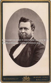 Eltham District Historical Society Inc
Photograph, Phillip Shillinglaw, c.1885
Photographer: Richards & Co. Portrait Parlours operated from 19 Sturt Street, Ballarat from 1881-1921 but with "Under Royal Patronage" appears to be 1881-1885. Phillip Shillinglaw was born Melbourne, August 7, 1842. He married Sarah Ann Kidd in Heidelberg, Victoria, February 28, 1872. In 1881 Phillip and Sarah and their small family moved to Eltham and made home in what was later to become known as Shillinglaw Cottage but which Phillip named 'Wattle Brae'. Shillinglaw Cottage is significant to Eltham’s local history. It is one of the earliest known buildings still in existence. Records suggest that the cottage was built circa 1859 by a man named Cochrane, believed to be Thomas Cochrane, in conjunction with George Stebbings though it is not known what Stebbings’s contribution was. It is believed Stebbings owned the cottage between 1874 and 1888. According to Margaret Ball’s (2017) book Shillinglaw Family of Eltham 1660-2007, Thomas Cochrane and family lived there from 1867 to 1874 however this is contrary to the records of assessable rates levied by the Eltham District Road Board, established in 1858, which shows Cochrane was the owner occupier (in Little Eltham) of approximately 25 acres of cultivated land and 25 acres of pastureland upon which a hut was sited in 1860. It is suspected that George Stebbings may have acquired the property from Cochrane in 1874 as it is noted that he had a tenant for a period, James Rossiter, who was the editor for the Evelyn Observer in Kangaroo Ground in 1874 (LATE SHIRE OFFICE AT KANGAROO GROUND (1934, February 16). Advertiser (Hurstbridge, Vic. : 1922 - 1939), p. 5. Retrieved February 25, 2022, from http://nla.gov.au/nla.news-article56743657). In 1881 Phillip Shillinglaw became the ratepayer for the cottage though Stebbings retained ownership until 1888 at which time it was transferred to Shillinglaw. CARTE-DE-VISITE (cdv) 1857-1890 Cartes-de-visite (cdv's) are the most common form of photograph from the nineteenth century, generally measuring two and a half inches by four and an eighth inches (6.3 x 10.5 cm) when mounted, sepia toned, mounted on a card which was generally printed with the photographer's name and address on the back or beneath the portrait. - Frost, Lenore; Dating Family Photos 1850-1920; Valiant Press Pty. Ltd., Berwick, Victoria 1991marg ball collection, shillinglaw family photo album 1, phillip shillinglaw (1842-1914), 1881-1885, 1885, richards & co. photographers 19 sturt st ballarat -
 Bendigo Military Museum
Map - Map Extract - Charterhouse of Mendip, John James Raisbeck, Unknown
Map extract showing the towns of Cheddar, Rodney Stoke, Westbury and a smaller town of Easton. The area depicted is part of Somerset, England. Map is hand drawn by J.J. Raisbeck date unknown. John James RAISBECK was born on 4 July 1880 at Christchurch New Zealand. He served 4 years (Citizen Military Force - CMF) in 9th Australian Light Horse Regiment in Central VIC with the rank 2nd Lieutenant. He was the first Australian appointed to the Survey Section RAE, on 16 April 1910, as a draughtsman which was his civilian profession, with the rank Warrant Officer, honorary 2nd Lieutenant. He was required to resign his commission in the CMF. He supervised the draughting work of the Section in Melbourne and was largely responsible for the mapping standards and specifications set in the production of the Cowes one-inch-to-one-mile military map, which became the enduring Australian standard. He was also responsible for supervising the printing of the maps by the Victorian Government Printer. He was appointed 2nd Lieutenant in the AIF Survey Corps draft on 6 December 1917 (from Melbourne) embarking for England on 22 December 17. He was attached to the Australian Corps Topographic Section in France from 21 April 1918 to 5 March 1919 serving as Second-in-Command and as Officer Commanding. He was promoted Lieutenant 15 October 1918, attending the AIF Survey School, Southampton in 1919, returning to Australia 23 June 1919, before his AIF appointment was terminated 17 July 1919. He went on to serve the Survey Section RAE and Australian Survey Corps, including in the Second World War, having been promoted Captain then Major and Officer Commanding Army Headquarters Cartographic Section until February 1940. He retired after 33 years of service to military survey, and after serving the Corps in two world wars, on 4 July 1943 with the retired rank Lieutenant-Colonel. He was the author of the article ‘A Short History of the Military Survey of Australia, 1907-1936’, published in The Australian Surveyor, Sept 1, 1937Map extract slightly larger than A4. Scale: One Inch to One and a half Mile. 1:31680, 9 x copiesSignature of "J.J. Raisbeck" bottom right-hand cornerroyal australian survey corps, rasvy, fortuna, army survey regiment, army svy regt, asr -
 Bendigo Military Museum
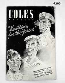
Booklet - BOOKLET, WW2, Johnson, Fear and Kingham PTY LTD, Coles Present "Knitting for the Forces", Post 1939
The booklet was published for “Coles Stores” Australia wide.The front cover shows in B & W drawings of the 3 Forces, inside is 15 pages in black print on white paper of instructions for knitting garments deemed most suitable for the Armed Forces as per the front cover.On the back of page 15 is a 7 inch ruler marking for measurement.coles, knitting -
 Bendigo Military Museum
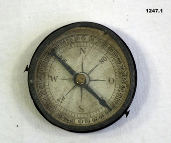
Equipment - COMPASS, PROTRACTOR, RULER, Est WWI
The 3 items belonged to Sgt Jack Grinton No 1043, 38th Batt AIF. The ruler was broken by a small piece of shrapnel which then passed through a wallet containing photos. Refer Cat No 1280 for service details. Refer 1317P, 1320P, 1241.22P, 1278.2. Part of the Grinton collection which included hundreds of negatives and developed photos that he took during the War..1) Pocket compass, metal and glass, mirror backed. .2) Protractor-wooden, metal stud and ring. .3) Ruler, wood, in 2 parts..2) "Veare wood" .3) One inch and centimetre increments.instruments-measuring, surveyors-terrestrial -
 Kew Historical Society Inc
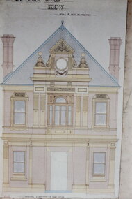
Slide - Architectural Drawing, Kew Public Offices, 1887
A civic campaign for new public offices developed in Kew in the 1880s. After much deliberation, the location chosen was the junction of Bulleen and Cotham Roads. The buildings were designed by George Watson and John Henry Harvey, architects within the Department of Public Works (Victoria). Building was commenced in 1887, and after one year, the buildings were opened. The Post Office was transferred to the new Commonwealth Government in 1901. The Police Station and Court House, sold by the Victorian Government to the City of Boroondara in 2007, are now a community cultural centre and performing arts venue.The buildings were listed on the Victorian Heritage Register Register (HO885) in 1991. They are historically and architecturally significant to the State Of Victoria because Watson and Harvey's designs exhibit diversity in integrating civil offices, they accommodate the apex of road junctions, and they demonstrate a departure from the contemporaneously favoured High Victorian Classical to the Queen Anne style in the design of civic buildings. 35mm colour transparency of an original plan by George Watson and John Henry Harvey, architects of the Department of Public Works (Victoria), in 1887 for New Public Offices at Kew. This plan was copied by the donor from an original held at the Commonwealth Archives in Brighton (Vic). The copy was made to illustrate a report that the donor made on ‘The functional planning design, building materials and construction methods of the Kew Post Office’ as part of course work at RMIT.THE PUBLIC OFFICES, KEW / SCALE 2 FEET TO ONE INCHkew court house, kew police station, architectural drawings, khs - slides, new public offices — kew (vic.), architecture — queen anne style -
 Kew Historical Society Inc
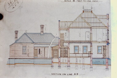
Slide - Architectural Drawing, Kew Public Offices, 1887
A civic campaign for new public offices developed in Kew in the 1880s. After much deliberation, the location chosen was the junction of Bulleen and Cotham Roads. The buildings were designed by George Watson and John Henry Harvey, architects within the Department of Public Works (Victoria). Building was commenced in 1887, and after one year, the buildings were opened. The Post Office was transferred to the new Commonwealth Government in 1901. The Police Station and Court House, sold by the Victorian Government to the City of Boroondara in 2007, are now a community cultural centre and performing arts venue.The buildings were listed on the Victorian Heritage Register Register (HO885) in 1991. They are historically and architecturally significant to the State Of Victoria because Watson and Harvey's designs exhibit diversity in integrating civil offices, they accommodate the apex of road junctions, and they demonstrate a departure from the contemporaneously favoured High Victorian Classical to the Queen Anne style in the design of civic buildings. 35mm colour transparency of an original plan by George Watson and John Henry Harvey, architects of the Department of Public Works (Victoria), in 1887 for New Public Offices at Kew. This plan was copied by the donor from an original held at the Commonwealth Archives in Brighton (Vic). The copy was made to illustrate a report that the donor made on ‘The functional planning design, building materials and construction methods of the Kew Post Office’ as part of course work at RMIT.SECTION ON LINE A-B / SCALE 8 FEET TO ONE INCHkew court house, kew police station, kew post office, architectural drawings, khs - slides, new public offices — kew (vic.), architecture — queen anne style -
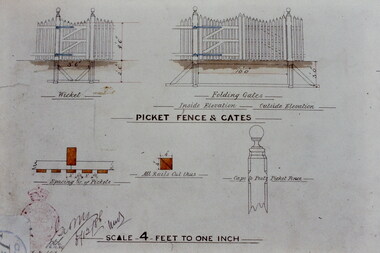 Kew Historical Society Inc
Slide - Architectural Drawing, Kew Public Offices, 1887
A civic campaign for new public offices developed in Kew in the 1880s. After much deliberation, the location chosen was the junction of Bulleen and Cotham Roads. The buildings were designed by George Watson and John Henry Harvey, architects within the Department of Public Works (Victoria). Building was commenced in 1887, and after one year, the buildings were opened. The Post Office was transferred to the new Commonwealth Government in 1901. The Police Station and Court House, sold by the Victorian Government to the City of Boroondara in 2007, are now a community cultural centre and performing arts venue.The buildings were listed on the Victorian Heritage Register Register (HO885) in 1991. They are historically and architecturally significant to the State Of Victoria because Watson and Harvey's designs exhibit diversity in integrating civil offices, they accommodate the apex of road junctions, and they demonstrate a departure from the contemporaneously favoured High Victorian Classical to the Queen Anne style in the design of civic buildings. 35mm colour transparency of an original plan by George Watson and John Henry Harvey, architects of the Department of Public Works (Victoria), in 1887 for New Public Offices at Kew. This plan was copied by the donor from an original held at the Commonwealth Archives in Brighton (Vic). The copy was made to illustrate a report that the donor made on ‘The functional planning design, building materials and construction methods of the Kew Post Office’ as part of course work at RMIT.PICKET FENCE & GATES / SCALE 4 FEET TO ONE INCHkew court house, kew police station, kew post office, architectural drawings, khs - slides, new public offices -- kew (vic.), architecture — queen anne style -
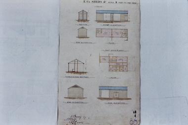 Kew Historical Society Inc
Slide - Architectural Drawing, Kew Public Offices, 1887
A civic campaign for new public offices developed in Kew in the 1880s. After much deliberation, the location chosen was the junction of Bulleen and Cotham Roads. The buildings were designed by George Watson and John Henry Harvey, architects within the Department of Public Works (Victoria). Building was commenced in 1887, and after one year, the buildings were opened. The Post Office was transferred to the new Commonwealth Government in 1901. The Police Station and Court House, sold by the Victorian Government to the City of Boroondara in 2007, are now a community cultural centre and performing arts venue.The buildings were listed on the Victorian Heritage Register Register (HO885) in 1991. They are historically and architecturally significant to the State Of Victoria because Watson and Harvey's designs exhibit diversity in integrating civil offices, they accommodate the apex of road junctions, and they demonstrate a departure from the contemporaneously favoured High Victorian Classical to the Queen Anne style in the design of civic buildings. 35mm colour transparency of an original plan by George Watson and John Henry Harvey, architects of the Department of Public Works (Victoria), in 1887 for New Public Offices at Kew. This plan was copied by the donor from an original held at the Commonwealth Archives in Brighton (Vic). The copy was made to illustrate a report that the donor made on ‘The functional planning design, building materials and construction methods of the Kew Post Office’ as part of course work at RMIT.E.C. SHEDS &c / SCALE 8 FEET TO ONE INCHkew court house, kew police station, kew post office, architectural drawings, khs - slides, new public offices -- kew (vic.), architecture — queen anne style -
The Ed Muirhead Physics Museum
Length Standards, Washington Certified, Archives
U.S. Bureau of Standards Certificates for #65 for 6 inch steel scale, 6 inch steel end measuring rod, 6 inch glass scale. Three Department of Commerce Bureau of Standards certificates submitted by Professor Lyle for scales made by H.J. Grayson. Held together by paper clip. (See also #62) -
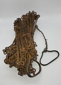 Glenelg Shire Council Cultural Collection
Equipment - Surveyors chain, unknown
Before metric measurement was introduced land was measured by a tool of chains and links called a surveyor's chain. The first surveyor's chain was designed by the English clergyman and mathematician Edmund Gunter (1581-1626) and introduced in 1620. It comprised of a metal chain made up of 100 links measuring a precise overall length of 66 ft or 22 yards, with each link measuring 7.92 inches (201.168 mm). The Gunter's chain was originally intended to be used in the accurate laying out and measurement of plots of land, for legal and commercial purposes, but was subsequently widely used by surveyors throughout the British Empire and Europe, with an Imperial mile being 80 times the Gunter's chain length. A tool used to survey the land before the introduction of the metric system.Surveyor chain Gunter type, 100 links measuring 66 feet in length. Hand grips at each end of chain. Wire links are approximately eight inches long. Incised tags or markers are attached to each tenth link of chain to assist with the more accurate recording of intermediate distances.surveying tool -
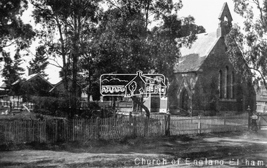 Eltham District Historical Society Inc
Negative - Photograph, Tom Prior, St Margaret's Church of England, Eltham, c.1910
Present day St Margaret's Anglican Church, Pitt Street, Eltham Photo: Tom Prior (maternal uncle to Ivy Reynolds) using his home-made cameraThis photo forms part of a collection of photographs gathered by the Shire of Eltham for their centenary project book,"Pioneers and Painters: 100 years of the Shire of Eltham" by Alan Marshall (1971). The collection of over 500 images is held in partnership between Eltham District Historical Society and Yarra Plenty Regional Library (Eltham Library) and is now formally known as the 'The Shire of Eltham Pioneers Photograph Collection.' It is significant in being the first community sourced collection representing the places and people of the Shire's first one hundred years. The Reynolds family were early settlers in Research. The Reynolds/ Prior collection of photographs were taken by Tom Prior, the maternal uncle of Ivy Reynolds, around 1900 and the 60 photos in the album give a fine overview of many of the landmarks of Research and Eltham over 100 years ago. lvy lived in the family home for many years at 106 Thompson Cres Research. Ivy's father, Ernst Richard Reynolds and grandfather, Richard Reynolds, lived at the same address. Ivy's father Richard worked for Mr. Trail on his property in Research. Reynolds Road is named after the family. Mr Tom Prior (wife Eva) worked at the Melbourne zoo. He was very innovative and made his own camera, using the black cloth hood to exclude the light. The photographs are a reminder of the rural nature of Research and Eltham and its rich heritage.Digital image 4 x 5 inch B&W Negchurch of england, eltham, pitt street, reynolds prior collection, sepp, shire of eltham pioneers photograph collection, st margarets anglican church -
4th/19th Prince of Wales's Light Horse Regiment Unit History Room
Framed Map, Tallarook, 12/11/1923
Tallarook was a training area of the Regiment1 Inch: 1 Mile map of Tallarook in glass fronted frame -
 Greensborough Historical Society
Map, City of Heidelberg: Residential Policy, 1976c
Shows residential zones 3, 4 & 5 established by Residential Policy adopted 13/12/1976Black print on waxed paper. Scale: 20 chs to 1 inchG M Hutchins. $1city of heidelberg, heidelberg -
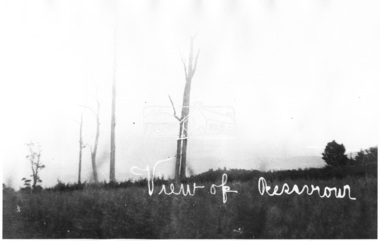 Eltham District Historical Society Inc
Photograph, View of Reservoir from Kinglake
View is of Yan Yean Reservoir, probably taken from Council land (1970) on Ganglehoffs Road.This photo forms part of a collection of photographs gathered by the Shire of Eltham for their centenary project book,"Pioneers and Painters: 100 years of the Shire of Eltham" by Alan Marshall (1971). The collection of over 500 images is held in partnership between Eltham District Historical Society and Yarra Plenty Regional Library (Eltham Library) and is now formally known as the 'The Shire of Eltham Pioneers Photograph Collection.' It is significant in being the first community sourced collection representing the places and people of the Shire's first one hundred years.Digital image and 4 x 5 inch B&W Negsepp, shire of eltham pioneers photograph collection, kinglake, reservoir, ganglehoffs road, yan yean reservoir -
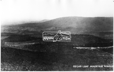 Eltham District Historical Society Inc
Photograph, Sugar Loaf Mountain, Kinglake
Possibly taken from Bald Spur LookoutThis photo forms part of a collection of photographs gathered by the Shire of Eltham for their centenary project book,"Pioneers and Painters: 100 years of the Shire of Eltham" by Alan Marshall (1971). The collection of over 500 images is held in partnership between Eltham District Historical Society and Yarra Plenty Regional Library (Eltham Library) and is now formally known as the 'The Shire of Eltham Pioneers Photograph Collection.' It is significant in being the first community sourced collection representing the places and people of the Shire's first one hundred years.Digital image and 4 x 5 inch B&W Negsepp, shire of eltham pioneers photograph collection, kinglake, sugarloaf mountain