Showing 1102 items
matching information map
-
 Marysville & District Historical Society
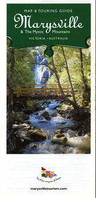
Map (Item) - Map and touring guide, Murrindindi Regional Tourism Association Inc, Marysville & The Mystic Mountains VICTORIA-AUSTRALIA, 08-2002
A fold out map and touring guide of Marysville and the surrounding district published in 2002 by Murrindindi Regional Tourism Association Inc.A fold out map and touring guide of Marysville and the surrounding district published in 2002 by Murrindindi Regional Tourism Association Inc.marysville, victoria, australia, map and touring guide, mystic mountains tourism, the beeches rainforest walk, lake mountain, cambarville, cathedral range state park, the cumberland, abbey green b&b cottages, anastasia fairytale cottage, ashlar cottage b&b, somerled mountain retreat, baree mudbrick cottages, blackwood cottages, camellia cottage, cathedral view b&b, cottage riverside, crossways country inn, dalrymples guest cottages, esa country ministries, hillcrest, keppels hotel motel, kerami house, lomatia lodge, lyell guest cottages, marylands country house, marysville caravan park, marysville holiday cottages, maryton park, melina cottage, moondai farm b&b, mountain lodge marysville, mount cathedral lodge, mystic mountains holiday cottages, nanda binya lodge, rendezvous on murchison, scenic b&b, the hermitage, tower motel, waratah house, willowbank at taggerty, woodlands of narbethong, keppels, lake mountain resort cafe, lanterns at willowbank, mantirri blueberry farm, marysville country bakery, the old woolshed cafe, clearstream olives, uncle fred & aunty val's old style lolly shop, acheron valley alpacas country store & gallery, bruno's art and sculpture garden, country touch, things of sand & stone, willowbank gallery, marysville auto & hardware, marysville newsagency & general store, marysville visitor information centre, narbethong visitor information centre, gallipoli park, keppels lookout, lady talbot drive, steavenson falls, steavenson river, taggerty river, acheron river, black spur trail riding centre, buxton trout farm, lake mountain resort ski hire, lake mountain ski school, marysville district country club, marysville ski centre, narbethong ski hire, rubicon horse riding, country touch tours, murrindindi regional tourism association inc -
 Marysville & District Historical Society
Map (Item) - Map and touring guide, Murrindindi Regional Tourism Association Inc, MARYSVILLE AND THE MYSTIC MOUNTAINS YARRA VALLEY-VICTORIA, Unknown
A fold out map and touring guide of Marysville and the surrounding district published by Murrindindi Regional Tourism Association Inc.A fold out map and touring guide of Marysville and the surrounding district published by Murrindindi Regional Tourism Association Inc.marysville, victoria, australia, map and touring guide, the cumberland, murrindindi regional tourism association inc, abbey green b&b, amberview lodge, anastasia fairytale cottage, ashlar cottage b&b, blackwood cottages, camellia log cabin, crossways country inn, dalrymples guest cottages, eagle mountain retreat, esa camping and conference centre, fruit salad farm, gilberts restaurant, keppels hotel motel, kerami house, kooringa resort and conference centre, lomatia lodge, lyelll guest cottages, marylands country house, marylyn holiday resort, marysville caravan park, marysville visitor information centre, alpacas at carmyle farm, australian adventure experience, bruno's art and sculpture garden, buxton trout farm, country touch tours, lake mountain, lake mountain ski hire, manical mechanicals, marysville district country club, marysville ski centre, rubicon valley horse riding, things of sand & stone, clearstream olives, the old woolshed cafe, fraga's cafe restaurant, lake mountain resort bistro, mantirri blueberry farm, gallipoli park, keppels lookout, cambarville, lady talbot drive, cathedral range state park, steavenson falls, steavenson river, taggerty river, acheron river, marysville auto and hardware, marysville newsagency & general store, narbethong visitor information centre, visit victoria -
 Marysville & District Historical Society
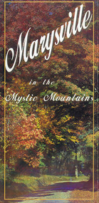
Map (Item) - Information brochure, Project Art & Photo, Marysville in the Mystic Mountains, Unknown
... Mountains Map Information brochure Project Art & Photo Mystic ...An information brochure on Marysville, the surrounding district and the natural attractions in the region published by Mystic Mountains Tourism.An information brochure on Marysville, the surrounding district and the natural attractions in the region published by Mystic Mountains Tourism.marysville, victoria, australia, information brochure, mystic mountains, mystic mountains tourism, cathedral range, lady talbot drive, cameron cascades, phantom falls, keppel falls, beech forest cascades, the beeches rainforest walk, the big tree, cumberland memorial scenic reserve, cambarville, cumberland falls, cora lynn falls, the big culvert, steavenson falls, lake mountain, marysville visitor information centre -
 Marysville & District Historical Society
Map (Item) - Tourist and business map, Narbethong Community and Tourism Group, Narbethong Buxton Taggerty Tourist and Business Map, 04-2008
A tourist and business map of Narbethong, Buxton and Taggerty. This map was produced by the Narbethong Community and Tourism Group in April 2008. It was produced to promote the natural attractions, adventure activities and food trail from the Black Spur, through Narbethong, Buxton and Taggerty.A tourist and business map of Narbethong, Buxton and Taggerty.This publication has been produced by the Narbethong Community and Tourism/ Group (NCTG) to promote the natural attractions, adventure activities and food/ trail from the Black Spur, through Narbethong, Buxton and Taggerty./ the information provided in this publication has been supplied by the individual/ members. NCTG takes no responsibility for its accuracy./ April 2008narbethong, buxton, taggerty, victoria, australia, tourist and business map, narbethong community and tourism group, acheron valley, yarra track, wood's point, black spur, mystic mountains, the meeting of the waters, cathedral range, danico design counted cross stitch, things of sand & stone, buxton zoo nursery & oddz & enz, willowbank at taggerty, safe trek 4wd services, pnl 4wdriving, buxton trout and salmon farm, mystic mountains ski hire & outdoors, narbethong ski hire, highwood health centre, cathedral view natural therapies, narby cabinets, plants by shelian, gb timber, executive signs, rb automotive repairs, buxton car care, marysville towing & equipment hire, martyn slade building design, cathedral peak framing, black spur roadhouse & ski hire, tudor lodge roadhouse & ski hire, buxton roadhouse & persian bazzar, buxton post office general store & niche bar, igloo roadhouse, taggerty store, narby eggs, marapana agistment park, mantirri blueberry farm, carmyle farm, hazelwood hazelnuts, south cathedral lavender farm, cathedral cherries, black spur motel & caravan park, woodlands rainforest retreat, chestnut glade, black spur inn, wombat cottage, abbey lake luxury b & b spa cottages, blue views holiday cottages, camp narbethong, marapana farm stay b & b, mantirri blueberry farm b & b, little dene garden cottages, silverstream b & b cottages, nareen cabins, moondai farm b & b, south cathedral farm luxury b & b cottages, yarrolyn caravan park, sarsens rest, lomah retreat, pinjarra gardens, kingbilli country estate, henry viii manor house, buxton hotel, butters cafe of buxton, wagtail wines, little river wines, lanterns at willowbank, wirrawilla rainforest walk, wilhemina falls, the cascades -
 Marysville & District Historical Society
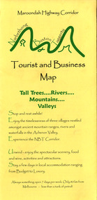
Map (Item) - Tourist and business map, Narbethong Community and Tourism Group, the Gateway TOURIST AND BUSINESS MAP, 08-2009
A tourist and business map of Narbethong, Buxton, and Taggerty. This map was produced by the Narbethong Community and Tourism Group Inc in August 2009. It was produced to promote the natural attractions, adventure activities, and food trail from the Black Spur, through Narbethong, Buxton, and Taggerty.A tourist and business map of Narbethong, Buxton and Taggerty.This publication has been produced by the Narbethong Community and Tourism Group Inc./ (NCTG) The information provided in this publication has been supplied by the individual/ members. NCTG takes no responsibility for its accuracy./ August 2009narbethong, buxton, taggerty, victoria, australia, tourist and business map, the gateway tourist and business map, black spur motel & caravan park, woodlands rainforest retreat, chestnut glade, black spur inn, wombat cottage, abbey lake luxury b&b spa cottages, camp narbethong, marapana farm stay b&b, mantirri b&b, little dene garden cottages, nareen cabins, silverstream b&b cottages, buxton hotel motel, south cathedral farm luxury b&b cottages, cathedral view b&b retreat, kingbilli country estate, cathedral valley farm, pinjarra gardens, willowbank at taggerty, sarsens rest, yarrolyn caravan park, danico design counted cross stitch, things of sand & stone, buxton zoo nursery, safetrek 4wd services, mystic mountains ski hire & outdoors, pnl 4wdriving, buxton trout and salmon farm, buxton bait and tackle, black spur roadhouse, tudor lodge service station roadhouse & ski hire, buxton roadhouse, buxton p.o. general store, igloo roadhouse, henry v111 manor house, buxton hotel, butters cafe, wagtail wines, little river wines, narby eggs, marapana agistment park, carmyle farm, hazelwood hazelnuts, cathedral view naturall therapies, cre8ing growth, linda hailey, naby cabinets, gb timber, narbethong timber & trading, rb automotive repairs, buxton car care, martyn slade building design, taggerty vet clinic -
 Marysville & District Historical Society
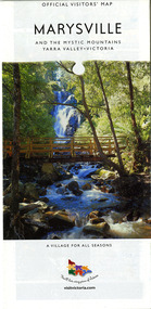
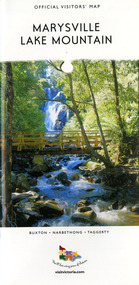
Map (Item) - Tourist map, Mystic Mountains Tourism, OFFICIAL VISITORS' MAP MARYSVILLE LAKE MOUNTAIN, Unknown
A visitors' map of Marysville and Lake Mountain produced by Mystic Mountains Tourism for Visit Victoria.A visitors' map of Marysville and Lake Mountain produced by Mystic Mountains Tourism for Visit Victoria.The Marysville and Lake Mountain Visitor Map and Touring Guide has been compiled and/ published by Mystic Mountains Tourism Inc. Copyright./ Production and artwork Graph Attack P/Lmarysville, lake mountain, victoria, australia, visitor's map, official visitors' map marysville lake mountain, buxton, narbethong, taggerty, visit victoria, mystic mountains tourism inc, graph attack p/l, mystic mountains, marysville triangle, marysville visitor information centre, marylands country house, black spur, steavenson falls, lady talbot drive, cambarville, cathedral ranges, wirreanda festival, lake mountain summit walk, summit walk loop, leadbeaters loop, day loop walk, buxton hotel, igloo roadhouse, karmann waters, silverstream b&b cottages, buxton trout and salmon farm, the niche wine bar, buxton post office & general store, choppers buxton roadhouse, woodlands rainforest bungalows, chestnut glade, black spur inn, wombat cottage, abbey lake luxury b&b spa cottages, mystic mountain ski hire & outdoors, pnl 4wdriving, blue views holiday units & ski hire, marapana agistment park & farm stay b&b, danico design, things of sand & stone, mantirri blueberry farm, allawah country cottages, amberview cottages, ashlar cottage b&b, black spur motel & caravan park, blackwood deluxe cottages, blackwood courtyard b&b, dalrymples guest cottages, delderfield, el kanah guest house, fruit salad farm, kerami guest house, keppels hotel, lake mountain-snow gum lodge, lomatia lodge, lyell guest cottages, magnolia house, keppel waters, lyrebird apartments, marysville caravan park, all view spa apartments, riverside cottages, maryton park b&b country cottages, melina cottage, mountain lodge, mystic mountains holiday cottages, nanda binya lodge, rendezvous luxury cottages, scenic b&b motel, the cumberland, south cathedral farm, tower motel, willowbank at taggerty, woodlands rainforest retreat, marysville & district country club inc, mystic mountains ski hire & outdoors, rubicon valley horse riding, marysville trout and salmon ponds, gallipoli park, keppels lookout, cambarville-yarra ranges national park, lake mountain-yarra ranges national park, lady talbot drive-yarra ranges national park, cathedral range state park, steavenson river, taggerty river, acheron river, lake mountain alpine resort, bruno's art and sculpture garden, manical mechanicals, uncle fred & aunty val's old style lolly shop, carmyle farm boutique, crossways historic country inn, fraga's, gilberts restaurant, heights licensed bistro, the old woolshed cafe, cathedral view natural therapies, crystal journey -
 Bendigo Military Museum
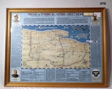
Map - MAP, FRAMED, Siege of Tobruk, Post 1945
Map & detailed description on framed information board. Tan coloured wooden frame, glass front, masonite backing, coloured detailed map of Tobruk area with history of area featured on blue border around map.Siege of Tobruk April - Dec 1941.documents-maps, frame accessories, tobruk -
 Frankston RSL Sub Branch
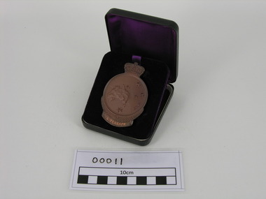
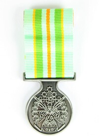
Medallion, ANZAC, Government issue, 50th Anniversary of Gallipoli Medallion
Circular bronze medallion surmounted by the Queen's crown. Obverse depicts Simpson and his donkey assisting a wounded man, a laurel wreath, the date '1915' and the word 'ANZAC'. Reverse depicts a map of Australia and New Zealand with the Southern Cross superimposed, fern fronds and the engraved name of the recipient 'A. PEARSON'. This medallion is in its original presentation case. The Anzac Medallion was issued by the Australian government in 1967 to commemorate the 1965 50th anniversary of the Gallipoli landings. The medallion was issued to surviving veterans of the campaign or their next of kin. Refer to AWM item for further information < http://www.awm.gov.au/collection/RELAWM16790.001/ >The name of the recipient, A. Pearson, is engraved on the reverse of this medallion. -
 Frankston RSL Sub Branch
Medallion, ANZAC, Government issue, 50th Anniversary of Gallipoli Medallion
Circular bronze medallion surmounted by the Queen's crown. Obverse depicts Simpson and his donkey assisting a wounded man, a laurel wreath, the date '1915' and the word 'ANZAC'. Reverse depicts a map of Australia and New Zealand with the Southern Cross superimposed, fern fronds and the engraved name of the recipient 'G. R. GRIFFITH'. This medallion is in its original presentation case. The Anzac Medallion was issued by the Australian government in 1967 to commemorate the 1965 50th anniversary of the Gallipoli landings. The medallion was issued to surviving veterans of the campaign or their next of kin. Refer to AWM item for further information < http://www.awm.gov.au/collection/RELAWM16790.001/ >The recipients name, G.R. Griffith, is engraved on the reverse of the medallion.ww1, gallipoli, medallion, g r, griffith -
 Frankston RSL Sub Branch
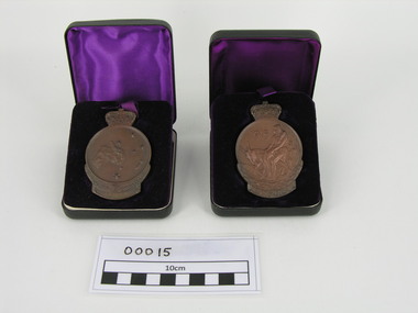
Medallions, ANZAC, 50th Anniversary of Gallipoli Medallions
Two medallions which were awarded to Australian World War 1 servicemen, T ENGLISH and C R C FERGUSSON, who had landed at Gallipoli in 1915. These medallions have been mounted on a burgundy felt backing and framed in a small gold coloured photo frame. Each is a circular bronze medallion surmounted by the Queen's crown. Obverse depicts Simpson and his donkey assisting a wounded man, a laurel wreath, the date '1915' and the word 'ANZAC'. Reverse depicts a map of Australia and New Zealand with the Southern Cross superimposed, fern fronds and the engraved name of the recipient. The Anzac Medallion was issued by the Australian government in 1967 to commemorate the 1965 50th anniversary of the Gallipoli landings. The medallion was issued to surviving veterans of the campaign or their next of kin. Refer to AWM item for further information < http://www.awm.gov.au/collection/RELAWM16790.001/ >There is an engraved label mounted within the picture frame with the inscription "ANZAC Medallions", "Issued to Tom English & C R C Fergusson".anzac, ww1, 1915, world war 1, gallipoli medallion -
 Frankston RSL Sub Branch
Pocketbook, Souvenir, Taschenbuch Groß-Deutschland, Geschichtstafel, Deutschlands Wehrmacht, Weltatlas, 31 August, 1941
provenance unknownSmall, soft cover, pocketbook presumably souvenired from a German soldier during the latter stages of World War 2. The pocketbook is of the type originally issued by the German military and was printed in August 1941, edited by Georg Westermann, Braunschweig. The book has a red coloured cover with black printing and contains 48 pages. Pages are printed in black, the maps are printed in colour. The pocketbook is in good condition, some pages have tears and the cover is scuffed. The pocket book title translates as "Paperback Greater Germany, History Chart, Germany's Wehrmacht, World Atlas" and is a collection of information about the German Reich, German military units and insignia and world maps, 1942 calendar, etc. The original owner has made markings on some maps and has made notes.The front cover is printed in black ink with the following "Taschenbuch Groß-Deutschland, Geschichtstafel, Deutschlands Wehrmacht, Weltatlas" -
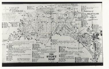 Phillip Island and District Historical Society Inc.
Photographs, Early 20th Century
Three photographs/postcards donated by J Gliddon234-01. Black & White photograph of The Story Map of Phillip Island with allotments shown and extremely detailed information typed on it by Vernon McHaffie. 234-02. Sepia postcard of the penguin rookery on "Little Nobby", Phillip Island. Man sitting on hill looking down at the rookery showing tracks & entrances to burrows. 234-03. Sepia postcard of two people sitting on top of cliff, Headland Rookery, with moulting penguins on their laps. 234-02. "Tom Tregellas" Nature Series No. 1. (Penguins) Phillip Island. Rookery on Little Nobby, showing tracks and entrances to burrows amongst the "pig-face" weed. 234-03. "Tom Tregellas" Nature Series No. 1. (Penguins) Phillip Island. Moulting Burrow on top of Cliff, Headland Rookery, which contained four birds. Note feathers outside burrow.phillip island map, phillip island allotments, vernon mchaffie, wildlife - penguins, penguins phillip island, penguin rookeries phillip island, j gliddon -
 Greensborough Historical Society
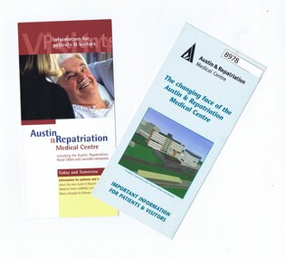
Pamphlet - Pamphlets, Austin & Repatriation Medical Centre 2001, July 2001
2 Pamphlets with information about the Austin & Repatriation Medical Centre and the Mercy Hospital for Women redevelopment in 2001.2 Colour pamphlets with text and photos, map.austin hospital, mercy hospital for women, heidelberg repatriation hospital, austin & repatriation medical centre -
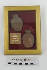
 Montmorency–Eltham RSL Sub Branch
Medal - Military Kid Medallion, Foxhole Medals, After 2004
This medal was presented to the children of Victorian Wing - Warrant Officer and Non Commissioned Officers Academy Soldier who have served on operational deployments. As these young children endured an operational deployment of a parent who spent many months away from home in a foreign country representing the Australian Army. Following operations include Bougainville, East Timor, Indian Ocean, Solomon Islands, Meddle East Area, Afghanistan and Sinai.Presented by the Government to children whose parents had served overseas Silver medal with pale green, yellow, orange and deeper green ribbon. It has a metal type container with a clear plastic front and also a black carry bag with Military Kid and print of medal on front. The design is based on the Australian Tri Service Logo. More detailed information can be found on Military Kids websiteOn reverse: "For perseverance on the home front during your parents deployment"; map of Australia (haut relief)military kid, military medal, kids medal -
 Mission to Seafarers Victoria
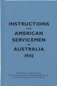
Book - Pocket book, Special Service Devision, Service of Supply, United States Army, Instructions for American Servicemen in Australia 1942, 2007
In 1942, the United States issued Instructions for American Servicemen in Australia as a quick guide to Australia's people, politics, history and culture for Americans stationed there during the Second World War. It was one of several similar sets of instructions put together by the US government to help its soldiers, sailors and airmen adjust to life abroad.Pocket size book of blue colour ix, [54] p. : ill., mapsnon-fictionIn 1942, the United States issued Instructions for American Servicemen in Australia as a quick guide to Australia's people, politics, history and culture for Americans stationed there during the Second World War. It was one of several similar sets of instructions put together by the US government to help its soldiers, sailors and airmen adjust to life abroad. 1942, american soldiers, australia -
 Mission to Seafarers Victoria
Photograph - Photographs, Serie, Mission to Seafarers Victoria, The sea is all around us, 29 May 2015
EXHIBITION in the DOME The Sea is All Around Us - Margaret Woodward 11-21 May 2015 Dome Gallery – Mission to Seafarers, 717 Flinders Street, Melbourne, Australia. 37 º 49'21" S 144º 57'03"E Hours: Daily 11.00am - 4.00pm The sea is all around us is a multi-layered event which will create a memorable experience for those visiting the Dome Gallery and the Mission to Seafarers in Melbourne’s Docklands. The event will acknowledge and raise awareness of the working lives and journeys of seafarers by making visible their role in transporting commodities, materials and objects to and from Australia’s shores. This installation invites seafarers and visitors to participate in a global project which aims to witness sea journeys and trace the mobile life of seafarers and souvenirs. For a fortnight in May 2015, the Dome Gallery will become an architectural large scale compass, with the circular floor marking the intersection of its latitude and longitude (37 º 49'21" S 144º 57'03"E). Over these two weeks the Dome Gallery will be inscribed with marks recording journeys made by seafarers, recording destination and departure ports, home lands and waterways, and in doing so making visible a small segment of the global patterns of seafaring. Custom-made souvenirs designed for the installation will be given to seafarers as gestures of welcome and a memento of their visit. The souvenirs originating in Poland will continue their journey by sea, to destinations beyond the Dome becoming part of the global network of seafaring, with an invitation for seafarers to record their future journeys using QR code scanning technologies. It is hoped that by releasing the 200 limited edition souvenirs accompanying the seafarers the mobile life of souvenirs and seafarers will also become visible. For more information visit the website: sensingtheremote.net Margaret Woodward is Associate Professor of Design at Charles Sturt University For a fortnight in May 2015, Margaret Woodward was ‘in residence’ at the Mission to Seafarers Norla Dome Gallery with her participatory installation project "The Sea is All Around Us". The floor of the gallery became a large scale compass. Seafarers were welcomed to the gallery their ships, journeys and destinations were recorded and mapped on the floor drawing. Seafarers were welcomed with cake and souvenir mugs of tea. These mugs, a momento for the seafarers, were inscribed with a scannable QR code and an invitation for seafarers to record their journeys on a dedicated project website. Around 120 souvenirs are now continuing their journey by sea and seafarers have scanned the mugs from locations including Singapore, Brisbane, Fremantle, Adelaide, Busan and Johor! After the exhibition Margaret Woodward was able to follow the seafarers' whereabout: ""The Sea is all Around Us". I am in awe of where this project might go, well done Margaret. One week has passed since finishing up at the Mission to Seafarers Victoria. Today I check my website and can see that the cup-carrying seafarers are reaching warmer climates, they tell me it’s getting hot as some are already in Suva and Port Lautoka. I’ve watched the souvenirs travel and fan out from Melbourne, some West to Adelaide and Fremantle, others going north to Sydney Brisbane, Singapore and Busan. Another seafarer scans in from Changi Airport, excited to be going home for some time with his family in the Phillipines. I keep an eye on my ‘fleet’ of 22 ships that visited the Dome Gallery, and see where they are on the Live Shipping website, watch some of them sail up the coast of Western Australia and marvel at the steady pace this journey takes. I am so used to flying over coastlines and countries in a matter of hours, impatiently watching the tracking screen from my airline seat, this shipping pace seems so much more real, so much more of a passage. I feel connected to these ships, to the people on board, to know that an object has passed from my hands to theirs, now holding in it my cargo of concern."margaret woodward, installation, exhibition, norla dome, 2015, sea voyage, sea journey, cultural events -
 Greensborough Historical Society
Document - Document Collection, Local Council Representation Review, 2019_
Contents: 2 x Newspaper Clippings: Banyule City Council Electoral Representative Review, Heidelberg Leader 20/08/2019 and Diamond Valley Leader 21/08/2019. Local Council Representative Review Submission Guide. Victorian Electoral Commission, 2019. 24 p., text. General information for those making a submission to a review. Local Council Representative Review Preliminary Report: Banyule City Council. Victorian Electoral Commission, August 2019. 31 p., text and colour maps. Reports on submissions and gives 3 options for electoral review in Banyule. Local Council Representative Review: Banyule City Council 1. Public hearing agenda and attachments. 25/09/2019. 9 p. 2. Public hearing agenda and attachments. 25/09/2019. 2 p. Agenda and handwritten notes by R. Bray. Local Council Representative Review Final Report: Banyule City Council. Victorian Electoral Commission, October 2019. 46 p., text and colour map. Recommends increasing the number of councillors and wards to 9. 2 newspaper clippings, 3 booklets and agenda with attachments. Filed in black plastic folder.banyule city council, victorian electoral commission, local council representative review 2019 -
 Greensborough Historical Society
Folder, Victorian democracy and Greensborough, compiled by Anne Paul, 2019_06
Outline of events leading to independent separate representative government for Victoria in 1850, and information on electoral districts and parliamentary members in the Greensborough and surrounding areas to date. Talk presented by Anne Paul to a GHS General meeting on 29 June 2019.90 p. in loose leaf ring binder. Text, maps and colour illustrations. Printed copy of PowerPoint presentationgreensborough, victoria parliament, anne paul -
 Greensborough Historical Society
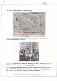
Article and Photograph, All Saints Anglican Church Greensborough, 2018_
Information and photographs of All Saints' Anglican Church Greensborough from the 1940s and 1950s. Includes a hand drawn map of the original site on the corner of Main Street and Grimshaw Street.This photograph and text was copied from a Facebook site. Members are people who lived in the Greensborough area and share their reminiscences of the area with others. The site is administered by a GHS member but is not officially affiliated with the Society. Any information is the opinion of the contributor. Article and photograph sourced from social media.all saints anglican church greensborough -
 Greensborough Historical Society
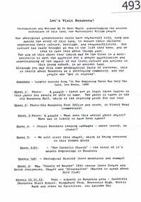
Article, Let's visit Bundoora, 1841o
... '. Includes copies of uncited articles; photos and maps. Background ...This collection of notes aims 'for a deeper appreciation and understanding of the impact of our lives; culture and actions;.in Bundoora; a developing community'. Includes copies of uncited articles; photos and maps.Background information on Bundoora in the 20th century.Collection of articles, possibly notes from an oral presentation. Complete document available at GHS."Contents largely sourced from "In the beginning there was only the land", Len Kenna, 1988." - note on page 1.bundoora -
 Greensborough Historical Society
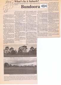
Newspaper Clipping, Bundoora: What's in a Suburb?, 16/09/2000
A short history of Bundoora from its earliest subdivision in 1838 to the end of the 20th century. Includes information on hospitals in the area - Larundel, Mont Park, 1 page, text, photos and map.bundoora, mont park -
 Greensborough Historical Society
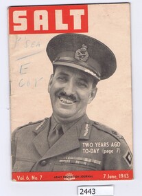
Magazine, Australia. Army. Australian Army Education Service, Salt. Vol.6 No.7, 7 June 1943, 07/06/1943
The Army Education Journal contains information for army personnel. This edition has articles on War Service Homes, rope work and several conflict areas.48 p., line drawings, maps.Vol. 6, No. 7australia. army, world war ii -
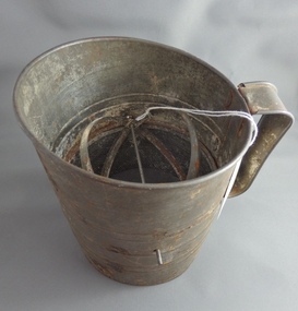 Greensborough Historical Society
Flour Sifter, Kande, Metal flour sifter, 1954c
This sifter was used at Poulter Avenue Greensborough for over 55 years.Owned and used by the Colvin family for over 55 years.Metal sifter with metal handle and green painted winder. Some rust damage and a hole in wire."Kande" brand inside outline map of Australia, stamped on side with patent information.flour sifter -
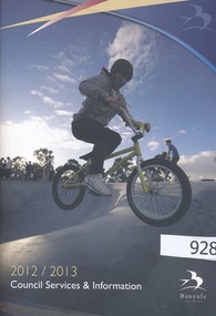 Greensborough Historical Society
Handbook, Banyule City Council Services and Information 2012/2013, 2012-2013
The 2012/2013 handbook of council services and information for the City of Banyule.An annual publication distributed to all homes in the Banyule local government area.56 pages, colour illustrationa and maps.banyule city council, city of banyule -
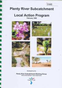 Greensborough Historical Society
Book, Plenty River Subcatchment: Local Action Plan / Plenty River Subcatchment Working Group, 1999_02
Plenty River Subcatchment Implementation Program was developed to provide information on local catchment management issues and actions to address these issues.44 page book in spiral binding. Col. illus and maps. 2 copies.plenty river, yarra river -
Glenelg Shire Council Cultural Collection
Pamphlet, Portland Holiday Centre of the South West, 1970s
... '. Coloured photos, map, tours and information.... 'Portland Holiday Centre of the South West'. Coloured photos, map ...Trifold pamphlet 'Portland Holiday Centre of the South West'. Coloured photos, map, tours and information. -
Glenelg Shire Council Cultural Collection
Map - Map- Tarragal, n.d
... Map - Tarragal - No further information supplied... - No further information supplied Map Map- Tarragal ...Map - Tarragal - No further information supplied -
Glenelg Shire Council Cultural Collection
Photograph - Photograph - Maritime Discovery Centre Gift Shop, c. 1998
Coloured photograph: inside Maritime Discovery Center, gift shop on left, young man standing in front of the information board about Great South West, map of Glenelg Shire on right.