Showing 819 items
matching mays park
-
 Learmonth and District Historical Society Inc.
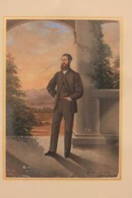
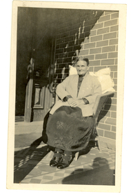
Photo - Richmond, Unknown, James Richmond
James Richmond was born at Hamilton ,Lanarkshire in Scotland on 24th November 1840.He migrated to Australia at age 21, on the sailing vessel "City of Melbourne", arriving 23rd July,1862.He made his way to the Ballarat district and secured a position as head teacher at Weatherboard Hill State School. On 25th April 1866 he was selected as the first full time Shire Secretary, at a starting salary of 250 pounds per annum, (the previous position having only been part time). On February 26th 1867 James married Annie Dobson and they had four sons and two daughters. Their residence was a dwelling attached to the original Shire Offices at Learmonth.During his term he took on various other roles. In July 1873 "Richmond Park" on the foreshore of Lake Learmonth was named in his honour.James Richmond died on 29th December,1879 (while still in office),from a severe attack of rheumatic fever at age 39, leaving Annie to raise their six children.First fulltime Shire Secretary of the Ballarat shire,1866-1879. Coloured painting of James Richmond set in narrow brown frame with cream mount and narrow "gold" edge around painting.in bottom right corner is marked "James Richmond age 28 1868" and on the right "W.H. R.A.S. May 1868.JAMES RICHMOND age 28 1868. W.H. R.A.S. May 1868richmond james 1840 1879, shire secretary 1866, weatherboard hill state school, richmond park learmonth -
 Cheese World Museum
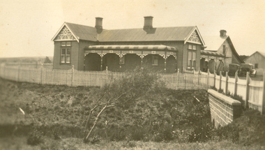
Photograph, Tooram Park homestead c1915, early 20th century
The Percy Uebergang family lived at Tooram Park, Allansford from 1912 until 1992. Percy and Myrtle Uebergang's children were twins, Ray and Joyce born in 1926 who lived at Tooram Park until their deaths, Ray in 1986 and Joyce in 1992. Neither Ray nor Joyce married and following the death of her brother Joyce set up the Ray and Joyce Uebergang Foundation which supports the local community. This photograph is part of the collection of items given into the care of the Cheese World Museum. The Uebergang family purchased Tooram Park in 1912. It was part of the original Tooram run which was taken up in 1839/40 by John McMahon Allan. Allan held the property until 1860 after which it passed through several owners including John Orlebar, Thomas McLeod Palmer, Owen family. Tooram was famous for the cheese from its large dairy herd. The herd was hand-milked. Palmer employed Indian labour to undertake this task. In 1883 Palmer was charged with the manslaughter of an Indian worker but was acquitted. This case was extensively reported in the Warrnambool Standard. The Standard also featured a number of articles about Tooram [22 June 1882, 17 March 1883 to 15 May 1993, 30 October 1886, 22 October 1897, 11 May 1926, 8 June 1931]. The property remained in the Uebergang family until after Joyce's death in 1992. Tooram is significant as it was one of the earliest runs taken up in the Warrnambool area. It was divided up following its sale in 1897. Tooram cheese was renowned. This photograph is significant as it shows Tooram Park homestead in its earlier days with the prolific timber decoration which was later removed.Black & white photograph on a cardboard mount showing Tooram Park homestead. The house has a white picket fence. A drain is in the foreground and is serviced by a stone culvert is in the right foreground. Two cars are parked in front of the house. The house walls are painted a dark colour. The verandah roof is striped dark and white. The timber decoration on the verandah, barge board and gable is white.allansford, tooram, tooram park, uebergang, john orlebar, john mcmahon allan, thomas mcleod palmer, owen family, indian labour, court cases, dairying, dairying, warrnambool standard -
 Flagstaff Hill Maritime Museum and Village
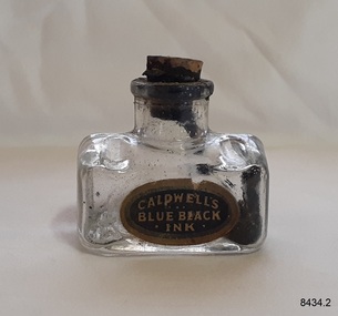
Container - Ink Bottle, Caldwell’s Ink Factory, Late 19th to early 20th centuries
This design of the bottle is sometimes called a ‘cottage’ or ‘boat’ shape. The Caldwell’s handmade glass ink bottle was mouth-blown into a three-piece mould, a method often used in the late 19th and early 20th centuries, with the maker's name engraved into the mould section for the base. The glass blower would cut the bottle off the end of his blowpipe with a tool and join a mouth onto the top, rolling the lip. The bottle was then filled with ink and sealed with a cork. This method of manufacture was more time-consuming and costly to produce than those made in a simple two-piece mould and 'cracked' off the blowpipe. The capacity for a bottle such as this was about 3 ½ oz (ounces) equal to about 100 ml. This particular bottle is unusual as it has four sloping indents at the corners of the shoulder, most likely for resting a pen with its nib upwards and the handle resting on a flat surface. Most of the bottles made during this era had horizontal pen rests that were indented into both of the long sides of the shoulder. Pen and ink have been in use for handwriting since about the seventh century. A quill pen made from a bird’s feather was used up until around the mid-19th century. In the 1850s a steel point nib for the dip pen was invented and could be manufactured on machines in large quantities. This only held a small amount of ink so users had to frequently dip the nib into an ink well for more ink. Handwriting left wet ink on the paper, so the blotting paper was carefully used to absorb the excess ink and prevent smudging. Ink could be purchased as a ready-to-use liquid or in powdered form, which needed to be mixed with water. In the 1880s a successful, portable fountain pen gave smooth-flowing ink and was easy to use. In the mid-20th century, the modern ballpoint pen was readily available and inexpensive, so the fountain pen lost its popularity. However, artisans continue to use nib pens to create beautiful calligraphy. Caldwell’s Ink Co. – F.R. Caldwell established Caldwell’s Ink Company in Australia around 1902. In Victoria, he operated from a factory at Victoria Avenue, Albert Park, until about 1911, then from Yarra Bank Road in South Melbourne. Newspaper offices were appointed as agencies to sell his inks, for example, in 1904 the New Zealand Evening Star sold Caldwell’s Flo-Eesi blue black ink in various bottle sizes, and Murchison Advocate (Victoria) stocked Caldwell’s ink in crimson, green, blue black, violet, and blue. Caldwell’s ink was stated to be “non-corrosive and unaffected by steel pens”. A motto used in advertising in 1904-1908 reads ‘Makes Writing a Pleasure’. Stationers stocked Caldwell’s products and hawkers sold Caldwell’s ink stands from door to door in Sydney in the 1910s and 1920s. In 1911 Caldwell promised cash for returned ink bottles and warned of prosecution for anyone found refilling his bottles. Caldwell’s Ink Stands were given as gifts. The company encouraged all forms of writing with their Australian-made Flo-Eesi writing inks and bottles at their impressive booth in the ‘All Australian Exhibition’ in 1913. It advertised its other products, which included Caldwell’s Gum, Caldwell’s Stencil Ink (copy ink) and Caldwell’s Quicksticker as well as Caldwell’s ‘Zac’ Cough Mixture. Caldwell stated in a 1920 article that his inks were made from a formula that was over a century old, and were scientifically tested and quality controlled. The formula included gallic and tannic acids and high-quality dyes to ensure that they did not fade. They were “free from all injurious chemicals”. The permanent quality of the ink was important for legal reasons, particularly to banks, accountants, commerce, municipal councils and lawyers. The Caldwell’s Ink Company also exported crates of its ink bottles and ink stands overseas. Newspaper advertisements can be found for Caldwell’s Ink Company up until 1934 when the company said they were the Best in the business for 40 years.This hand-blown bottle is significant for being the only bottle in our collection with the unusual sloping pen rests on its shoulder. It is also significant for being made in a less common three-piece mould. The method of manufacture is representative of a 19th-century handcraft industry that is now been largely replaced by mass production. The bottle is of state significance for being produced by an early Melbourne industry and exported overseas. This ink bottle is historically significant as it represents methods of handwritten communication that were still common up until the mid-20th century when fountain pens and modern ballpoint pens became popular and convenient and typewriters were becoming part of standard office equipment.Ink bottle; rectangular base, hand-blown clear glass bottle with its own cork. The bottle has side seams from the base to the mouth, an indented base and an applied lip. The corners of the shoulder sides have unusual diagonal grooves that slope down and outwards that may have been used as pen rests. Inside the bottle are remnants of dried blue-black ink. The glass has imperfections and some ripples on the surface. The bottle has an attached oval black label label with gold-brown printed text and border. The base has an embossed inscription. The bottles once contained Caldwell’s blend of blue black ink.Printed on label; “CALDWELL's BLUE BLACK INK” Embossed on the base "CALDWELLS"flagstaff hill, warrnambool, maritime village, maritime museum, shipwreck coast, great ocean road, ink, nib pen, writing ink, writing, copying, banks, lawyers, commerce, student, permanent ink, blue black ink, stationery, record keeping, handwriting, writing equipment, writing accessory, office supply, cottage bottle, boat bottle, mouth-blown bottle, cork seal, f r caldwell, caldwell’s ink company, albert park, south melbourne, inkstands, stencil ink, copy ink, quicksticker, zac cough mixture, three part mould, cauldwells, cauldwell's -
 Marysville & District Historical Society
Ephemera (Item) - Information sheet, Disney Entertainment Pty Ltd, JIM BROWN VISITS MARYSVILLE, 1995
An information sheet about Episode 12 of the television program Healthy Wealthy and Wise from May 1995. Healthy, Wealthy and Wise was a lifestyle television program shown in Australia. It was shown on Network Ten and was aired from 1992 until 1998. Jim Brown was the program's travel presenter.An information sheet pertaining to Episode 12 of the television program healthy wealthy & wise from May, 1995.EP. 12. MONDAY, 1st May, 1995marysville, victoria, australia, information sheet, healthy wealthy and wise, jim brown, stevensons falls, steavenson falls, lady talbot drive, lady talbot forest drive, cumberland reserve, valley of the giants, david rackman, dalrymples guest cottages, maryton park, mathilde's of marysville, lake mountain, disney entertainment pty ltd -
Marysville & District Historical Society
Book (Item) - Ebook, Artworkz Tourism, Marysville Gallery, 05-2012
An ebook on various attractions to be visited in and around Marysville. This ebook was published by Artworkz Tourism in May 2012.An ebook on various attractions to be visited in and around Marysville.cambarville, cambarville waterfalls, cathedral state park, cora lynn falls, historic trestle bridge, jock's lookout, lady talbot drive, keppel falls, keppel hut, keppel lookout, gallipoli park, phantom falls, steavenson falls, taggerty river, taggerty cascades, the beeches rainforest walk, the big culvert, the big tree, meeting of the waters marysville, meeting of the waters buxton, marysville, victoria, australia, ebook -
 Bunjil Park Aboriginal Education & Cultural Centre
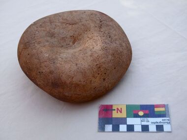
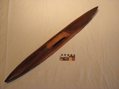
grinding stone, Double sided grinding stone with multiple hollows
Grindstones like this were not carried but hidden in special places with subtle indicators known only to the same tribe or nation. The small and deep nature of the pits suggests this rock may have been used for ochre with the smaller pits being used for water or fat to mix with the pigments. The very hard and dense nature of the rock means materials would not be contaminated during the grinding process.This rock is likely to be very old and is potentially significant from ceremonial perspective. Stones like this have been known to be passed on through multiple generations and been in use for hundreds and possibly thousands of years.This grindstone has hollows on both sides. One large hollow on one side measures approximately 7 cm across and 2 cm deep. The opposite side is distinguished by 3 pits, one large (5 cm wide by 3 cm deep) and two small indentations 2cm by 1cm. The hollows have been chipped and smoothed. The base rock is in the shape of a flattened and slightly elongated sphere, it appears to have been water worn.The side with three pits also bears recent scratches believed to be cut by a disk plough. It also appears to have a capital "W" inscribed in the largest pit.jaara, hidden, grindstone, ochre, quartzite, multiple hollows, pits, aboriginal food and art -
 Bunjil Park Aboriginal Education & Cultural Centre
fighting shield, Before european settlement
This wooden shield was used in hand to hand fighting between Jaara people and other tribes and with European settlers. It was made for personal use by one warrior and would have been passed on to his next nearest male kin. If it did not fit them, it would have been placed with the body of the warrior.This shied was gifted to Uncle Brien Nelson when he was working in Portland. This wooden fighting shield is undecorated and fashioned for use in either the left or right hand. It is elongated finishing in points at the top and bottom. It is carved from a single piece of wood and has a handle carved into the back. The shield has some minor striations on the front which may have been produced during fighting -
 Australian Jazz Museum
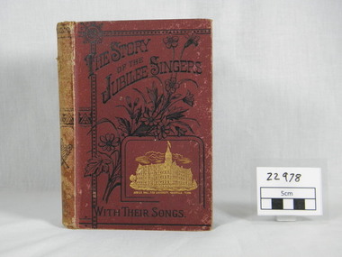
Book, Marsh, J.B.T, The story of the Jubilee Singers with their songs, 1887 (exact)
The Fisk Jubilee Singers toured Australia in the late 1880s arriving at the Melbourne port of Williamstown on May 14, 1886, giving 80 concerts, their first performance being at the Melbourne Town Hall on June 7.Rare hard cover book. Includes personal history of singers. Includes music and words to 128 songs. Preface to music written by Theo F. Seward.jubilee singers, ella sheppard -
 Australian Jazz Museum
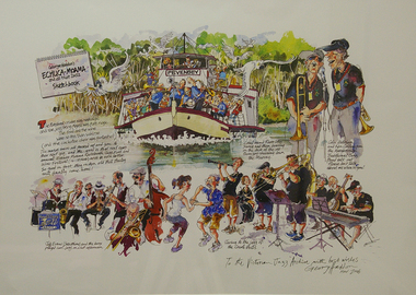
Cartoon, 16/2/2006 (estimated)
Poster sized Watercolor cartoon 16-18th February 2006To the Victorian Jazz Archive with best wishes George Haddon May 2006 -
 Eltham District Historical Society Inc
Photograph, Hume and Hovell Monument, Broadford, Autumn Excursion, Hume and Hovell's 1824 expedition, 26 May 1996, 26/05/1996
[article by Bettina Woodburn in EDHS Newsletter No. 109, July 1996:] ON THE TRAIL OF HUME AND HOVELL - REPORT ON THE AUTUMN EXCURSION - On a green and fresh morning (Sunday 26th May 1996) the Cobb and Co coach (driven by the most obliging Peter Tampion) set off in a north easterly direction from Eltham to connect with Hume and Hovell's route on their 1824 explorations of central Victoria. The Society would follow a series of monuments erected for the 1924 centenary of the expedition from King Parrot Creek (Tuesday 7th December 1824), through Strath Creek, over Sunday Creek (Sunday 12th December 1824) at Broadford, Tullamarine, St Albans, Deer Park, through Werribee, skirting east of the You Yangs to Lara and Avalon Beach. Because their distance-measuring wheel had broken and a one degree mistake was made in calculations, the two leaders of the original group of six convict-companions arrived at Corio Bay, instead of the expected Western Port, discovered earlier by Flinders. From below Mt. Disappointment (Hume and Hovell's difficulties in "scrambling over brush and rock", "leeches in forest, as well as no water", "cutting grass 4-5 ft. high", dreadful scrub", "devil flies") we took an easier route, saw the Strath Creek memorial in ground fog and a wonderful "field of dreams", the Hume-Hovell privately owned cricket ground with its white picket boundary fence. Now, after a steep climb, in sunshine under gums we stretched and viewed magnificent rolling hills and fog-filled valleys - not "smoke from Aborigines' bush fires". After morning tea at Broadford we followed the Sunday Creek valley beside the Hume Freeway, passed the Wallan Wallan Rest Area (more appropriately Hume and Hovell Rest Area) to tum right at Beveridge. In Gellibrand Hill Park, near the headwaters of the Moonee Ponds Creek, we experienced the landscape the first European settlers saw - huge river red gums and rolling pastures. The gardens and sheltered courtyard of the 1840s, timber, brought from .....[?] prefabricated Woodlands Homestead, provided a pleasant lunch stop. We enjoyed a private tour, panoramic views over Melbourne and surroundings and the excitement of arriving and departing aircraft. Our next river crossing was at Werribee, "in a vast treeless plain", then we drove on by-ways no coach had previously travelled, to find "an immense sheet of water" salty Corio Bay, off-course to the west. In late afternoon of a super, calm, late autumn day we headed homewards. Back at Eltham we were rather surprised to find that we had travelled a total of 347 km. Thanks again to Russell Yeoman for his research and organization. What a wonderful day! Colour photographactivities, broadford, hume and hovell, monument -
 Eltham District Historical Society Inc
Photograph, Strath Creek, Autumn Excursion, Hume and Hovell's 1824 expedition, 26 May 1996, 26/05/1996
[article by Bettina Woodburn in EDHS Newsletter No. 109, July 1996:] ON THE TRAIL OF HUME AND HOVELL - REPORT ON THE AUTUMN EXCURSION - On a green and fresh morning (Sunday 26th May 1996) the Cobb and Co coach (driven by the most obliging Peter Tampion) set off in a north easterly direction from Eltham to connect with Hume and Hovell's route on their 1824 explorations of central Victoria. The Society would follow a series of monuments erected for the 1924 centenary of the expedition from King Parrot Creek (Tuesday 7th December 1824), through Strath Creek, over Sunday Creek (Sunday 12th December 1824) at Broadford, Tullamarine, St Albans, Deer Park, through Werribee, skirting east of the You Yangs to Lara and Avalon Beach. Because their distance-measuring wheel had broken and a one degree mistake was made in calculations, the two leaders of the original group of six convict-companions arrived at Corio Bay, instead of the expected Western Port, discovered earlier by Flinders. From below Mt. Disappointment (Hume and Hovell's difficulties in "scrambling over brush and rock", "leeches in forest, as well as no water", "cutting grass 4-5 ft. high", dreadful scrub", "devil flies") we took an easier route, saw the Strath Creek memorial in ground fog and a wonderful "field of dreams", the Hume-Hovell privately owned cricket ground with its white picket boundary fence. Now, after a steep climb, in sunshine under gums we stretched and viewed magnificent rolling hills and fog-filled valleys - not "smoke from Aborigines' bush fires". After morning tea at Broadford we followed the Sunday Creek valley beside the Hume Freeway, passed the Wallan Wallan Rest Area (more appropriately Hume and Hovell Rest Area) to tum right at Beveridge. In Gellibrand Hill Park, near the headwaters of the Moonee Ponds Creek, we experienced the landscape the first European settlers saw - huge river red gums and rolling pastures. The gardens and sheltered courtyard of the 1840s, timber, brought from .....[?] prefabricated Woodlands Homestead, provided a pleasant lunch stop. We enjoyed a private tour, panoramic views over Melbourne and surroundings and the excitement of arriving and departing aircraft. Our next river crossing was at Werribee, "in a vast treeless plain", then we drove on by-ways no coach had previously travelled, to find "an immense sheet of water" salty Corio Bay, off-course to the west. In late afternoon of a super, calm, late autumn day we headed homewards. Back at Eltham we were rather surprised to find that we had travelled a total of 347 km. Thanks again to Russell Yeoman for his research and organization. What a wonderful day! Colour photographactivities, monument, hume and hovell, murchison valley, strath creek -
 Eltham District Historical Society Inc
Photograph, Murchison Gap viewed from Strath Creek, Autumn Excursion, Hume and Hovell's 1824 expedition, 26 May 1996, 26/05/1996
[article by Bettina Woodburn in EDHS Newsletter No. 109, July 1996:] ON THE TRAIL OF HUME AND HOVELL - REPORT ON THE AUTUMN EXCURSION - On a green and fresh morning (Sunday 26th May 1996) the Cobb and Co coach (driven by the most obliging Peter Tampion) set off in a north easterly direction from Eltham to connect with Hume and Hovell's route on their 1824 explorations of central Victoria. The Society would follow a series of monuments erected for the 1924 centenary of the expedition from King Parrot Creek (Tuesday 7th December 1824), through Strath Creek, over Sunday Creek (Sunday 12th December 1824) at Broadford, Tullamarine, St Albans, Deer Park, through Werribee, skirting east of the You Yangs to Lara and Avalon Beach. Because their distance-measuring wheel had broken and a one degree mistake was made in calculations, the two leaders of the original group of six convict-companions arrived at Corio Bay, instead of the expected Western Port, discovered earlier by Flinders. From below Mt. Disappointment (Hume and Hovell's difficulties in "scrambling over brush and rock", "leeches in forest, as well as no water", "cutting grass 4-5 ft. high", dreadful scrub", "devil flies") we took an easier route, saw the Strath Creek memorial in ground fog and a wonderful "field of dreams", the Hume-Hovell privately owned cricket ground with its white picket boundary fence. Now, after a steep climb, in sunshine under gums we stretched and viewed magnificent rolling hills and fog-filled valleys - not "smoke from Aborigines' bush fires". After morning tea at Broadford we followed the Sunday Creek valley beside the Hume Freeway, passed the Wallan Wallan Rest Area (more appropriately Hume and Hovell Rest Area) to tum right at Beveridge. In Gellibrand Hill Park, near the headwaters of the Moonee Ponds Creek, we experienced the landscape the first European settlers saw - huge river red gums and rolling pastures. The gardens and sheltered courtyard of the 1840s, timber, brought from .....[?] prefabricated Woodlands Homestead, provided a pleasant lunch stop. We enjoyed a private tour, panoramic views over Melbourne and surroundings and the excitement of arriving and departing aircraft. Our next river crossing was at Werribee, "in a vast treeless plain", then we drove on by-ways no coach had previously travelled, to find "an immense sheet of water" salty Corio Bay, off-course to the west. In late afternoon of a super, calm, late autumn day we headed homewards. Back at Eltham we were rather surprised to find that we had travelled a total of 347 km. Thanks again to Russell Yeoman for his research and organization. What a wonderful day! Colour photographactivities, hume and hovell, murchison valley, murchison gap, strath creek -
 Eltham District Historical Society Inc
Photograph, Autumn Excursion, Hume and Hovell's 1824 expedition, 26 May 1996, 26/05/1996
[article by Bettina Woodburn in EDHS Newsletter No. 109, July 1996:] ON THE TRAIL OF HUME AND HOVELL - REPORT ON THE AUTUMN EXCURSION - On a green and fresh morning (Sunday 26th May 1996) the Cobb and Co coach (driven by the most obliging Peter Tampion) set off in a north easterly direction from Eltham to connect with Hume and Hovell's route on their 1824 explorations of central Victoria. The Society would follow a series of monuments erected for the 1924 centenary of the expedition from King Parrot Creek (Tuesday 7th December 1824), through Strath Creek, over Sunday Creek (Sunday 12th December 1824) at Broadford, Tullamarine, St Albans, Deer Park, through Werribee, skirting east of the You Yangs to Lara and Avalon Beach. Because their distance-measuring wheel had broken and a one degree mistake was made in calculations, the two leaders of the original group of six convict-companions arrived at Corio Bay, instead of the expected Western Port, discovered earlier by Flinders. From below Mt. Disappointment (Hume and Hovell's difficulties in "scrambling over brush and rock", "leeches in forest, as well as no water", "cutting grass 4-5 ft. high", dreadful scrub", "devil flies") we took an easier route, saw the Strath Creek memorial in ground fog and a wonderful "field of dreams", the Hume-Hovell privately owned cricket ground with its white picket boundary fence. Now, after a steep climb, in sunshine under gums we stretched and viewed magnificent rolling hills and fog-filled valleys - not "smoke from Aborigines' bush fires". After morning tea at Broadford we followed the Sunday Creek valley beside the Hume Freeway, passed the Wallan Wallan Rest Area (more appropriately Hume and Hovell Rest Area) to tum right at Beveridge. In Gellibrand Hill Park, near the headwaters of the Moonee Ponds Creek, we experienced the landscape the first European settlers saw - huge river red gums and rolling pastures. The gardens and sheltered courtyard of the 1840s, timber, brought from .....[?] prefabricated Woodlands Homestead, provided a pleasant lunch stop. We enjoyed a private tour, panoramic views over Melbourne and surroundings and the excitement of arriving and departing aircraft. Our next river crossing was at Werribee, "in a vast treeless plain", then we drove on by-ways no coach had previously travelled, to find "an immense sheet of water" salty Corio Bay, off-course to the west. In late afternoon of a super, calm, late autumn day we headed homewards. Back at Eltham we were rather surprised to find that we had travelled a total of 347 km. Thanks again to Russell Yeoman for his research and organization. What a wonderful day! Colour photographactivities, hume and hovell -
 Eltham District Historical Society Inc
Photograph, Sign to Hume and Hovell Cricket Ground, at Allandale Road, Strath Creek, Autumn Excursion, Hume and Hovell's 1824 expedition, 26 May 1996, 26/05/1996
[article by Bettina Woodburn in EDHS Newsletter No. 109, July 1996:] ON THE TRAIL OF HUME AND HOVELL - REPORT ON THE AUTUMN EXCURSION - On a green and fresh morning (Sunday 26th May 1996) the Cobb and Co coach (driven by the most obliging Peter Tampion) set off in a north easterly direction from Eltham to connect with Hume and Hovell's route on their 1824 explorations of central Victoria. The Society would follow a series of monuments erected for the 1924 centenary of the expedition from King Parrot Creek (Tuesday 7th December 1824), through Strath Creek, over Sunday Creek (Sunday 12th December 1824) at Broadford, Tullamarine, St Albans, Deer Park, through Werribee, skirting east of the You Yangs to Lara and Avalon Beach. Because their distance-measuring wheel had broken and a one degree mistake was made in calculations, the two leaders of the original group of six convict-companions arrived at Corio Bay, instead of the expected Western Port, discovered earlier by Flinders. From below Mt. Disappointment (Hume and Hovell's difficulties in "scrambling over brush and rock", "leeches in forest, as well as no water", "cutting grass 4-5 ft. high", dreadful scrub", "devil flies") we took an easier route, saw the Strath Creek memorial in ground fog and a wonderful "field of dreams", the Hume-Hovell privately owned cricket ground with its white picket boundary fence. Now, after a steep climb, in sunshine under gums we stretched and viewed magnificent rolling hills and fog-filled valleys - not "smoke from Aborigines' bush fires". After morning tea at Broadford we followed the Sunday Creek valley beside the Hume Freeway, passed the Wallan Wallan Rest Area (more appropriately Hume and Hovell Rest Area) to tum right at Beveridge. In Gellibrand Hill Park, near the headwaters of the Moonee Ponds Creek, we experienced the landscape the first European settlers saw - huge river red gums and rolling pastures. The gardens and sheltered courtyard of the 1840s, timber, brought from .....[?] prefabricated Woodlands Homestead, provided a pleasant lunch stop. We enjoyed a private tour, panoramic views over Melbourne and surroundings and the excitement of arriving and departing aircraft. Our next river crossing was at Werribee, "in a vast treeless plain", then we drove on by-ways no coach had previously travelled, to find "an immense sheet of water" salty Corio Bay, off-course to the west. In late afternoon of a super, calm, late autumn day we headed homewards. Back at Eltham we were rather surprised to find that we had travelled a total of 347 km. Thanks again to Russell Yeoman for his research and organization. What a wonderful day! Colour photographactivities, hume and hovell, allandale road, strath creek -
 Eltham District Historical Society Inc
Photograph, Autumn Excursion, Hume and Hovell's 1824 expedition, 26 May 1996, 26/05/1996
[article by Bettina Woodburn in EDHS Newsletter No. 109, July 1996:] ON THE TRAIL OF HUME AND HOVELL - REPORT ON THE AUTUMN EXCURSION - On a green and fresh morning (Sunday 26th May 1996) the Cobb and Co coach (driven by the most obliging Peter Tampion) set off in a north easterly direction from Eltham to connect with Hume and Hovell's route on their 1824 explorations of central Victoria. The Society would follow a series of monuments erected for the 1924 centenary of the expedition from King Parrot Creek (Tuesday 7th December 1824), through Strath Creek, over Sunday Creek (Sunday 12th December 1824) at Broadford, Tullamarine, St Albans, Deer Park, through Werribee, skirting east of the You Yangs to Lara and Avalon Beach. Because their distance-measuring wheel had broken and a one degree mistake was made in calculations, the two leaders of the original group of six convict-companions arrived at Corio Bay, instead of the expected Western Port, discovered earlier by Flinders. From below Mt. Disappointment (Hume and Hovell's difficulties in "scrambling over brush and rock", "leeches in forest, as well as no water", "cutting grass 4-5 ft. high", dreadful scrub", "devil flies") we took an easier route, saw the Strath Creek memorial in ground fog and a wonderful "field of dreams", the Hume-Hovell privately owned cricket ground with its white picket boundary fence. Now, after a steep climb, in sunshine under gums we stretched and viewed magnificent rolling hills and fog-filled valleys - not "smoke from Aborigines' bush fires". After morning tea at Broadford we followed the Sunday Creek valley beside the Hume Freeway, passed the Wallan Wallan Rest Area (more appropriately Hume and Hovell Rest Area) to tum right at Beveridge. In Gellibrand Hill Park, near the headwaters of the Moonee Ponds Creek, we experienced the landscape the first European settlers saw - huge river red gums and rolling pastures. The gardens and sheltered courtyard of the 1840s, timber, brought from .....[?] prefabricated Woodlands Homestead, provided a pleasant lunch stop. We enjoyed a private tour, panoramic views over Melbourne and surroundings and the excitement of arriving and departing aircraft. Our next river crossing was at Werribee, "in a vast treeless plain", then we drove on by-ways no coach had previously travelled, to find "an immense sheet of water" salty Corio Bay, off-course to the west. In late afternoon of a super, calm, late autumn day we headed homewards. Back at Eltham we were rather surprised to find that we had travelled a total of 347 km. Thanks again to Russell Yeoman for his research and organization. What a wonderful day! Colour photographactivities, hume and hovell -
 Eltham District Historical Society Inc
Photograph, Autumn Excursion, Hume and Hovell's 1824 expedition, 26 May 1996, 26/05/1996
[article by Bettina Woodburn in EDHS Newsletter No. 109, July 1996:] ON THE TRAIL OF HUME AND HOVELL - REPORT ON THE AUTUMN EXCURSION - On a green and fresh morning (Sunday 26th May 1996) the Cobb and Co coach (driven by the most obliging Peter Tampion) set off in a north easterly direction from Eltham to connect with Hume and Hovell's route on their 1824 explorations of central Victoria. The Society would follow a series of monuments erected for the 1924 centenary of the expedition from King Parrot Creek (Tuesday 7th December 1824), through Strath Creek, over Sunday Creek (Sunday 12th December 1824) at Broadford, Tullamarine, St Albans, Deer Park, through Werribee, skirting east of the You Yangs to Lara and Avalon Beach. Because their distance-measuring wheel had broken and a one degree mistake was made in calculations, the two leaders of the original group of six convict-companions arrived at Corio Bay, instead of the expected Western Port, discovered earlier by Flinders. From below Mt. Disappointment (Hume and Hovell's difficulties in "scrambling over brush and rock", "leeches in forest, as well as no water", "cutting grass 4-5 ft. high", dreadful scrub", "devil flies") we took an easier route, saw the Strath Creek memorial in ground fog and a wonderful "field of dreams", the Hume-Hovell privately owned cricket ground with its white picket boundary fence. Now, after a steep climb, in sunshine under gums we stretched and viewed magnificent rolling hills and fog-filled valleys - not "smoke from Aborigines' bush fires". After morning tea at Broadford we followed the Sunday Creek valley beside the Hume Freeway, passed the Wallan Wallan Rest Area (more appropriately Hume and Hovell Rest Area) to tum right at Beveridge. In Gellibrand Hill Park, near the headwaters of the Moonee Ponds Creek, we experienced the landscape the first European settlers saw - huge river red gums and rolling pastures. The gardens and sheltered courtyard of the 1840s, timber, brought from .....[?] prefabricated Woodlands Homestead, provided a pleasant lunch stop. We enjoyed a private tour, panoramic views over Melbourne and surroundings and the excitement of arriving and departing aircraft. Our next river crossing was at Werribee, "in a vast treeless plain", then we drove on by-ways no coach had previously travelled, to find "an immense sheet of water" salty Corio Bay, off-course to the west. In late afternoon of a super, calm, late autumn day we headed homewards. Back at Eltham we were rather surprised to find that we had travelled a total of 347 km. Thanks again to Russell Yeoman for his research and organization. What a wonderful day! Colour photographactivities, hume and hovell -
Glen Eira Historical Society
Document - CAULFIELD CITIZENS ADVICE BUREAU
This file contains 2 items: 1/Original copy of 17th Annual Report of city of Caulfield Citizens Advice Bureau September 1987. Report includes Agenda for the Annual General Meeting held at City Hall on Wednesday 30091987, list of office bearers, minutes of the previous AGM, election of Management Committee and presentation of Life memberships plus list of Legal Advice Service solicitors. 2/Original copy of Agenda and 25th Annual Report for Caulfield Citizens Advice Bureau Incorporated presented to the Annual General meeting on 30/08/1995 at Caulfield City Hall. Report includes financial statement F Y E 30/06/1995, details of President’s Report, minutes of previous AGM in 1994.caulfield, citizen’ advice bureau, meetings, caulfield city hall, annual report, grants, edwards mavis, hocking john, green carol, coad thelma, harry carol, hession dorothy, lambert sam, moorrees joyce, ravenscroft jean, rowland dorothy, tyrell audrey, snowball betty, telford nancy, jelleff jenny, kay yvonne, bannister jean, fooks john, allsop doris, bullivant trudy, capek irene, carr fred, cairncross gwen, gorden peg, daniels maurice, davey dulcie, gresham greta, gresham john, hicks margaret, hind lillian, jacombs ken, joseph marion, kinross jo, lukies arthur, lukies noela, mander clive, miles glad, moser ellen, popper irene, poynton ray, splatt betty, stewart may, telford nancy, wray shirley, watson beth, chapman john, felder ilse, helman anne, mccarthy marie, richardson elizabeth, steward derek, williams marcia, blacher rosa, heyman manfred, tanner ted mla, dunstan don. cr, martens veronika cr, legge mary, crossley rosemary, malvern citizens’ advice bureau, deal communication centre, child joan mp, macphee ian hon mp, shipton roger mp, mccutcheon andrew mla, campbell jack, mayor, mayoress, campbell mrs., rudzki brian cr, milne sandy, fusion, moyle gwen, westlake margaret, gild anne, herszfeld henry, lee alf, lee rae, peters leanie, pratt lillian, trumble joan, wise john, nicholls harry, grist molly, payne ruth, victorian association of citizens’ advice bureaus, emergency relief funds, community buses, sinisgalli john, aroni beni, chisholm john, erlichster george, folkers herman, jackson ross, kraus michael, lewis ray, oliver michael, romer andrew, simons adrian, smith simon, legal advice services, solicitors, budget advisory service, voluntary workers, sanders kathy, allan bill, bible richard, bilston ron, birch harry, coad laurie, durra frank, glass alf, gild ann, grew doreen, hawker harry, hollow neil, hingert lorna, jack ian, jones alf, mann gordon, mansfield joan, marks yvonne, menzies edna, ohis wil, powell dave, pate gwen, pentland dilys, simmons dianne, ward george, whitehead richard, wills anne, local government, aged people, bullen rose, culkan stephanie, dukes claire, klinger rosa, lambert douglas, sheehan jean, trodd carrie, brady vera, bristow joyce, byrne enid, cornall-reilly patience, cornall-reilly arthur, rowland alan, caulfield city council, hostels, elsternwick, caulfield festival, caulfield park, maple street, st. johns uniting church elsternwick, caulfield contract, regent community for the elderly, caulfield hospital, royal district nursing service, mence wendy, gubieski joanne, preston dennis, ross moya, hall chloe, patience geoff, o’reilly mary, wraight geoff, thompson john, britton cath, thompson laurel, ross erwin, chapman john, carnie elza, coutts fay, goodman dianne, groat shirley, mclean phyllis, may tallilah, o’neil barbara, rosauer tom, shmerling lane, wedgwood amanda, gartside sandy, bucker ille, anderson ian, bonvicin rita, bridges judy, brooks lisa, bull rita, chin simone, ethell margaret, coupe jilie, klinger rosa, hogan tamara, harcourt-king judaline, lipp jonathan, mclver ken, murphy francis, mueller britt, moray debra, pinter sarolta, mctwerrey kay, nicholas norma, rae nicolle, simmons shirley, sumner laurie, bevis phyllis, cader estelle, crerar dorothy, egan hazel, gregoric kerry, glouzman kon, johnston peter, kamer john, lalacona flora, law russ, lipovetsky sergey, moroney dawn, kieth parsonson, pierce lorna, strickland joan, hall michael, mcgregor allan, shalit barbara, symons ian, community information centre, victorian association of community information centres (vacic), st. giles presbyterian church murrumbeena, st. mary’s anglican church caulfield, st. patrick’s catholic church murrumbeena, caulfield-elsternwick ecumenical ministry network, ladies probus club of caulfield, donovan mrs., windley mrs., van der vlies mrs. p., gorden p., gorden g., city of caulfield, barrett james cr, gold nicholas cr, welsh heather cr, boyle barry, barker ann, crean simon m.h.r., oxenbould wenzel, ashton matthew, lawrence mark, holding c. m.h.r., asher l. m.l.c., brideson a. m.l.c., guest j. m.l.c., biggs e. cr, grossbard a. cr, rogers a., terry g., va.c.a.b., coburn d., rodgers j., kelly j., caulfield community care, trevorrow a., trevorrow d., gleeson j., carnegie resource centre, elsternwick library, milne d., lister i., stone marjorie, larkin mary, patience jean, volunteer aid service, monitoring and social support service, community transport service, caulfield citizen advice bureau incorporated, community organisations -
Glen Eira Historical Society
Letter - Whittaker, G, Mrs
File contains 2 items: 1/ A handwritten letter by Mrs G. Whittaker on her personal memories/recollections of South Caulfield, which includes neighbours’ transport, homes, businesses and properties, some of which may have been included in ‘Sand, Swamp and Heath’ by Murray and Wells. 2/ Handwritten research note dated 27/09/2013 by Peta Darke concerning Mrs Whittaker’s parents’ house.whittaker g mrs, caulfield, flowers street, council employees, caulfield council, chinese community, market gardens, quong sing, bealiba road, trams, bambra road, glenhuntly road, glen huntly road, pearce’s nursery, nurseries, pearce mr, prisoners, pearce street, chloris street, benbow family, griffiths brothers teas, griffiths street, longs bull paddock, long mr, methodist church, hawthorn road, camden town methodist, mcconchie harry, mcconchie cricket ii, glenhuntly road, camden court, freeman street, lomax frederick, chloris park -
Glen Eira Historical Society
Article - Ormond Baseball Club
This file contains seven items. A stencilled letter from the Ormond Baseball club addressed to a member extending an invitation to a Reunion Smoke Night at the pavilion at Ormond Park, dated 28/07/2961 An article from the Caulfield/Port Phillip Leader on the division two standings where Ormond Glenhuntly Baseball Club was ranked twelve out of fourteen teams, 21/12/2010 An article from the Caulfield/Port Phillip Leader stating that Ormond Glenhuntly Baseball Club are one of three teams who are battling not to finish in last place, dated 11/01/2011 An article from the Caulfield/Port Phillip Leader in which Ormond Glenhuntly Baseball Club are ranked thirteen out of fourteen teams on the ladder, dated 11/01/2011 An article from the Caulfield/Port Phillip Leader in which Ormond Glenhuntly Baseball Club are said to be performing poorly, dated 15/02/2011 An article from the Caulfield/Port Phillip Leader in which Ormond Glenhuntly Baseball Club are ranked twelve out of fourteen teams on the ladder, dated 06/03/2012 A two-page extract from the pamphlet Community Snapshot produced by the Bendigo Bank on the records set by Ormond Glenhuntly Baseball Club in the 2012-13 season, dated May 2013ormond baseball club, baseball clubs, ormond, clubs, associations, sports, recreations, competitions, sporting clubs, leisure, cultural events, cultural associations, sports grounds, ovals, ormond glenhuntly baseball club, parks, reserves, sports people, summer league, armstrong ian, entertainment, oakleigh crescent, glenhuntly, caulfield/port phillip leader, bendigo bank, ogbc, hoenig jeff, ormond-mckinnon community bank, glen eira council, ee gunn reserve, lygris manny -
 Federation University Historical Collection
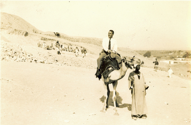
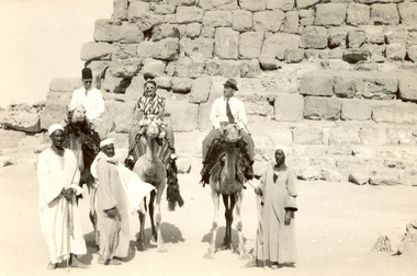
Photograph - Black and White, Frank Wright riding a camel, May 1940
Frank Wright was a renown resident of Smeaton, where he was born. He lived at Laura Villa, and attended Smeaton State School. His father William was a gold miner and his mother's name was Sarah. Their family won many singing and instrumental awards. Frank was tutored by Percy Code and was awarded a gold medal for the highest marks in the ALCM examinations in the British Colonies at the age of seventeen years. He became the Australian Open Cornet Champion by the age of eighteen. A year later, Frank conducted the City of Ballarat Band, and later the Ballarat Soldiers’ Memorial Band. He formed the Frank Wright Frisco Band and Frank Wright and his Coliseum Orchestra. These bands won many South Street awards, and Frank as conductor won many awards in the Australian Band Championship contest. In 1933 Frank Wright sailed to England to conduct the famous St Hilda’s Band and was later appointed Musical Director of the London County Council, where he organized many amazing concerts in parks, in and around the London district. He was made Professor of Brass and Military Band Scoring and conducted at the Guildhall of Music and Drama. Frank was often invited to adjudicate Brass Band Championships around Europe, in Australia, including South Street and in New Zealand. The Frank Wright Medal at the Royal South Street competition is awarded to an individual recognized as making an outstanding contribution to brass music in Australia.Black and white photograph of a man riding a camel and being led by a dark skinned man in flowing robes.In the background are other more indistinct people and animals. The man is Frank Wright and the place is near the Pyramids in Egypt.Handwritten on back - Near Pyramids, May 1940frank wright, cornet, conductor, camel, pyramid, egypt -
 Federation University Historical Collection
Photograph - Photograph - Black and White, Sarah Wright at 214 Armstrong (North) Street, 1928, 1928
Sarah Wright was married to a gold miner named William. They lived at Laura Villa, Smeaton. Their family won many singing and instrumental awards. Frank Wright their son was born and attended Smeaton State School and was a renown resident of Smeaton. Frank was tutored by Percy Code and was awarded a gold medal for the highest marks in the ALCM examinations in the British Colonies at the age of seventeen years. He became the Australian Open Cornet Champion by the age of eighteen. A year later, Frank conducted the City of Ballarat Band, and later the Ballarat Soldiers’ Memorial Band. He formed the Frank Wright Frisco Band and Frank Wright and his Coliseum Orchestra. These bands won many South Street awards, and Frank as conductor won many awards in the Australian Band Championship contest. In 1933 Frank Wright sailed to England to conduct the famous St Hilda’s Band and was later appointed Musical Director of the London County Council, where he organized many amazing concerts in parks, in and around the London district. He was made Professor of Brass and Military Band Scoring and conducted at the Guildhall of Music and Drama. Frank was often invited to adjudicate Brass Band Championships around Europe, in Australia, including South Street and in New Zealand. The Frank Wright Medal at the Royal South Street competition is awarded to an individual recognized as making an outstanding contribution to brass music in Australia. Laura Ritchie was his sister.Black and white photograph of a woman in a long dark skirt and light cardigan sitting on a chair with a pillow behind her back. The chair is on the verandah of a brick house. The woman is Sarah Wright and the house belongs to her daughter Laura Ritchie at 214 Armstrong St Nth, Ballarat.Written in pen on the back May 1928. Written in pencil 214 Armstrong St Northsarah wright. frank wright, laura ritchie, armstrong street, ballarat -
 Federation University Historical Collection
Photograph - Black and White, St Hilda's Band at Hyde Park, London, May 1934, May 1934
... St Hilda's Band at Hyde Park, London, May 1934... Hilda's Band, Hyde Park, London, May 1934... Conducting St Hilda's Band, Hyde Park, London, May 1934 Black ...Frank Wright was a renown resident of Smeaton, where he was born. He lived at Laura Villa, and attended Smeaton State School. His father William was a gold miner and his mother's name was Sarah. Their family won many singing and instrumental awards. Frank was tutored by Percy Code and was awarded a gold medal for the highest marks in the ALCM examinations in the British Colonies at the age of seventeen years. He became the Australian Open Cornet Champion by the age of eighteen. A year later, Frank conducted the City of Ballarat Band, and later the Ballarat Soldiers’ Memorial Band. He formed the Frank Wright Frisco Band and Frank Wright and his Coliseum Orchestra. These bands won many South Street awards, and Frank as conductor won many awards in the Australian Band Championship contest. In 1933 Frank Wright sailed to England to conduct the famous St Hilda’s Band and was later appointed Musical Director of the London County Council, where he organized many amazing concerts in parks, in and around the London district. He was made Professor of Brass and Military Band Scoring and conducted at the Guildhall of Music and Drama. Frank was often invited to adjudicate Brass Band Championships around Europe, in Australia, including South Street and in New Zealand. The Frank Wright Medal at the Royal South Street competition is awarded to an individual recognized as making an outstanding contribution to brass music in Australia.Black and white photograph of a rotunda situated in Hyde Park, London. A band is seated within the rotunda with the conductor standing at the front. In the foreground are seats with a couple of spectators. The band is St Hilda's and the conductor is Frank Wright.Written in pencil on back - Frank Wright Conducting St Hilda's Band, Hyde Park, London, May 1934frank wright, cornet, conductor, london, rotunda, st hilda's band -
 Federation University Historical Collection
Photograph - Black and White, A Party of Camels in front of a Pyramid, 1940, May 1940
Frank Wright was a renown resident of Smeaton, where he was born. He lived at Laura Villa, and attended Smeaton State School. His father William was a gold miner and his mother's name was Sarah. Their family won many singing and instrumental awards. Frank was tutored by Percy Code and was awarded a gold medal for the highest marks in the ALCM examinations in the British Colonies at the age of seventeen years. He became the Australian Open Cornet Champion by the age of eighteen. A year later, Frank conducted the City of Ballarat Band, and later the Ballarat Soldiers’ Memorial Band. He formed the Frank Wright Frisco Band and Frank Wright and his Coliseum Orchestra. These bands won many South Street awards, and Frank as conductor won many awards in the Australian Band Championship contest. In 1933 Frank Wright sailed to England to conduct the famous St Hilda’s Band and was later appointed Musical Director of the London County Council, where he organized many amazing concerts in parks, in and around the London district. He was made Professor of Brass and Military Band Scoring and conducted at the Guildhall of Music and Drama. Frank was often invited to adjudicate Brass Band Championships around Europe, in Australia, including South Street and in New Zealand. The Frank Wright Medal at the Royal South Street competition is awarded to an individual recognized as making an outstanding contribution to brass music in Australia.Black and white photograph of a party of three people, two men and a woman sitting on camels being held by their keepers. They are standing in front of the Great Pyramid in Egypt. The man on the right is Frank Wright.Written in pencil on the back - at the Great Pyramid, May 1940frank wright, camels, great pyramid, egypt -
 Federation University Historical Collection
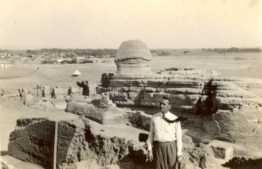
Photograph - Black and White, Frank Wright at the Sphinx, 1940, May 1940
Frank Wright was a renown resident of Smeaton, where he was born. He lived at Laura Villa, and attended Smeaton State School. His father William was a gold miner and his mother's name was Sarah. Their family won many singing and instrumental awards. Frank was tutored by Percy Code and was awarded a gold medal for the highest marks in the ALCM examinations in the British Colonies at the age of seventeen years. He became the Australian Open Cornet Champion by the age of eighteen. A year later, Frank conducted the City of Ballarat Band, and later the Ballarat Soldiers’ Memorial Band. He formed the Frank Wright Frisco Band and Frank Wright and his Coliseum Orchestra. These bands won many South Street awards, and Frank as conductor won many awards in the Australian Band Championship contest. In 1933 Frank Wright sailed to England to conduct the famous St Hilda’s Band and was later appointed Musical Director of the London County Council, where he organized many amazing concerts in parks, in and around the London district. He was made Professor of Brass and Military Band Scoring and conducted at the Guildhall of Music and Drama. Frank was often invited to adjudicate Brass Band Championships around Europe, in Australia, including South Street and in New Zealand. The Frank Wright Medal at the Royal South Street competition is awarded to an individual recognized as making an outstanding contribution to brass music in Australia.Black and white photograph of a man in shirt sleeves standing amongst the large cut stones at the back end of the Sphinx. In front of the Sphinx are the ruins of a temple, in the middle background is a large tent and further back are the buildings of a town. The man is Frank Wright and the place is Egypt.Written in pencil on the back - F.W. at Sphinx showing old Temple in background, May 1940frank wright, conductor, egypt, sphinx -
 Federation University Historical Collection
Photograph - Black and White, Frank Wright at the Pyramids, 1940, May 1940
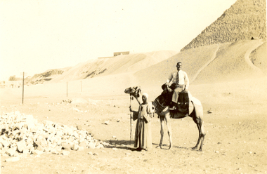
Frank Wright was a renown resident of Smeaton, where he was born. He lived at Laura Villa, and attended Smeaton State School. His father William was a gold miner and his mother's name was Sarah. Their family won many singing and instrumental awards. Frank was tutored by Percy Code and was awarded a gold medal for the highest marks in the ALCM examinations in the British Colonies at the age of seventeen years. He became the Australian Open Cornet Champion by the age of eighteen. A year later, Frank conducted the City of Ballarat Band, and later the Ballarat Soldiers’ Memorial Band. He formed the Frank Wright Frisco Band and Frank Wright and his Coliseum Orchestra. These bands won many South Street awards, and Frank as conductor won many awards in the Australian Band Championship contest. In 1933 Frank Wright sailed to England to conduct the famous St Hilda’s Band and was later appointed Musical Director of the London County Council, where he organized many amazing concerts in parks, in and around the London district. He was made Professor of Brass and Military Band Scoring and conducted at the Guildhall of Music and Drama. Frank was often invited to adjudicate Brass Band Championships around Europe, in Australia, including South Street and in New Zealand. The Frank Wright Medal at the Royal South Street competition is awarded to an individual recognized as making an outstanding contribution to brass music in Australia.Black and white photograph of a man sitting on a camel with the keeper standing at the camel's head. To the left is a pile of rocks and the rest of the background is sand rising to a dune and to the right is part of an Egyptian pyramid. The man is Frank Wright.Written in pencil on back - At the Pyramids, May 1940frank wright, egypt, pyramid, sand dune, camel -
 Federation University Historical Collection
Plan, Burrumbeep, 1884, 16/10/1884
Auctions of Crown land were introduced in the Colony of Victoria from 1851 to encourage settlers to occupy and work the land. Many squatters purchased land at auction at the upset (minimum) price of £1 per acre. In some areas where demand was high, such as the goldfields, the price realised at auction was much more. Land was put up for sale in the study area on the Burrumbeep run in May 1855, on the Lexington run in 1857, and on the Gorrinn run in 1858. (http://www.ararat.vic.gov.au/library/document/thermatics.pdf, accessed 27 January 2015) For 70 years or more, Yalla-y-Poora, Burrumbeep, Edgarley, Mount William and Narrapumelap ranked in the leading wool producers in Victoria. 1 Stud owners at Yalla-y-Poora, Eurambeen, Burrumbeep and Challicum crossed merino sheep with sheep descended from John Macarthur's Camden Park in New South Wales. (http://www.ararat.vic.gov.au/library/document/thermatics.pdf, accessed 27 January 2015) In what was to become the Ararat Mining Division, gold was discovered in May 1854 on the Burrumbeep run at a place that became known as Pinky Point on the Mount William goldfield. By 21 June 1854, between 600 and 1,000 people had arrived. (http://www.ararat.vic.gov.au/library/document/thermatics.pdf, accessed 27 January 2015)\ Town allotment plan for Burrumbeep. Merrymbuela, Borung, Lexington and Langi Logan are neighbouring areas. The plan includes the Burrumbeep Pre-Emptive Right (Roger and Wright); licensed land holders including Stephen Young, John Carroll, William Walsh, Thomas Purcell, Martha M. Bond, Colin Johnson, John Charles Webb, Henry Withycombe, William Henry Barbridge, John Wall, Thomas Flatelly, William Jenkinson, Elisia Radford, V. Radford, Denis Byrne, George Cook. Land holders included Andrew Maloney, Richard Wingfield Harrocks, W. Sporton, Terence Lynch, F. S. Falkiner, A. Millman, H. Morris, George Upham, J. McCLure, S. Fletcher, W. Parker, Thomas Myers, William wright, W.C. Winter, C. Wordman, Oliver A. Winter This plan is associated with former Ballarat School of Mines student Richard Squire (1875-6) Gift of the Squire FamilyVerso written in pencil - Plan of Burrembeep Ararat Burrembeep Araratburrumbeep, corrinn, langi logan, merrymbuela, lexington, ararat, roger & wright, cook, rogers, upham, george upham, ross, parsans, morris, johnson, withycoombe, colin johnson, falkiner, dsporton, john carroll, donald gordon, denis bryne, maurice dooley, martha bond, william harricks, \william wingfield harricks, william l.c. harricks, michael houlihan, thomas purcell, martin ryan, michael cody, fletcher, mccaw, w. parker, j.m. clow, elisia radford, thomas radford, thomas myers, barbridge, e. wilde, j. wall, flatelly, g. wardman, w.c. winter, david ball, jenkinson, ballarat school of mines, richard squire, squire