Showing 2550 items
matching no 76
-
 Bendigo Historical Society Inc.
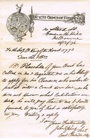
Document - ANCIENT ORDER OF FORESTERS NO. 3770 COLLECTION: CORRESPONDENCE
Letter from John King to Court King of the Forest and dated 1/12/76. Letter mentions clearance and administrative matters for Br Plaochte. Impression of Court Clarendon seal on bottom of page and a printed letterhead.societies, aof, correspondence, ancient order of foresters no. 3770 collection - correspondence, court king of the forest, br plaochte, john king, court clarendon 3545 emerald hill -
 Bendigo Historical Society Inc.
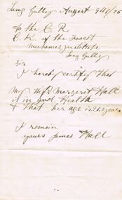
Document - ANCIENT ORDER OF FORESTERS NO 3770 COLLECTION: NOTE FROM JAMES HALL
Note from James Hall to the C.R. of C. K. of the Forest, Mechanics Institute, Long Gully certifying that his Wife Margaret Hall was in good Health and signed by James Hall. Dated August 9th/76.societies, aof, correspondence, ancient order of foresters no 3770 collection - note from james hall, court king of the forest, mechanics institute, margaret hall -
 Warrnambool and District Historical Society Inc.
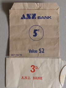
Envelope, Bank envelope ANZ, Mid 20th century
These enveloped have been used by the A.N.Z. Bank as a convenient way of storing coins. The one containing threepences is pre-decimal currency (1966) and other (five cents) is post 1966. The envelopes would have been used in all ANZ banks. The ANZ Bank was formed in 1951 when the Bank of Australasia merged with the Union Bank. The Bank of Australasia was established in Warrnambool in 1854 and in 1953 the Bank of Australasia and the Union Bank closed and the ANZ bank opened in Timor Street. Today a branch of the ANZ bank is in Liebig Street. These envelopes are of minor interest as examples of the currencies and banking procedures of yesteryear. These are two paper envelopes, glued at the ends, one for holding five cent coins and the other for threepenny coins. They are buff-coloured, with the larger envelope having blue printing and the smaller one having red printing. Larger envelope: ANZ Bank, 5c, value $2, 957-10/76 Smaller envelope: 3d. A.N.Z. Bank anz bank, threepences, warrnambool -
 National Wool Museum
Book, Knitting, Cleckheaton Design 0045
This pattern book was produced by Cleckheaton and contains knitting patterns for womens garments.Cleckheaton / IRISH DOWN / Design 0045 / Cardigan Sizes: 71 - 107 cm / Jumper Sizes: 76 - 102 cmknitting handicrafts - history, cleckheaton, knitting, handicrafts - history -
 Kew Historical Society Inc
Plan - Subdivision Plan, H C Crouch, Old Golf Links Estate, 1930s
The land in North Kew between the Outer Circle Railway and the River Yarra was released in sections. This release included 80 lots. Most of this area was released during the Depression years in the early 1930s.Subdivision plans are historically important documents used as evidence of the growth of suburbs in Australia. They frequently provide information about when the land was sold on which a built structure was subsequently constructed as well as evidence relating to surveyors and real estate and financial agents. The numerous subdivision plans in the Kew Historical Society's collection represent working documents, ranging from the initial sketches made in planning a subdivision to printed plans on which auctioneers or agents listed the prices for which individual lots were sold. In a number of cases, the reverse of a subdivision plan in the collection includes a photograph of a house that was also for sale by the agent. These photographs provide significant heritage information relating house design and decoration, fencing and household gardens.One part of a massive subdivision of the Old Golf Links Estate in North Kew of 80 allotments bordering Sutherland Avenue, Ramsay Avenue, Belford Road, Beresford Street and Coleman Avenue. Inset on the plan at the top left, the route of the Outer Circle Railway is clearly marked. The Kew Golf Links is identified in its current location. The land on which Greenacres Golf Club was to be constructed is at this time marked as ‘Recreation Ground’. The ‘new bridge’ over the Yarra at Burke Road is also marked on the inset map. The Plan identifies the surveyor (sic) H.C. Crouch BCE MVIS, 443 Little Collins St., Melbourne. The date of the subdivision auction sale in identified as Saturday September 25th at three o'clock.Annotations: "E" top left. "Golf Links" top right. Lots 73-76 ticked and listed as "6" poundssubdivisions -- kew (vic.), old golf links estate -
 National Wool Museum
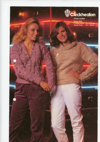
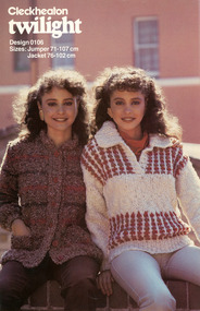
Booklet - Pattern Booklet, Cleckheaton Design 0106, Cleckheaton, 1980s - 1990s
Four page fold out knitting pattern booklet featuring a colour image on the cover of two women wearing knitted jumpers and jeans.front: [printed] Cleckheaton / twilight / Design 0106 / Sizes: Jumper 71 - 107 cm / Jacket 76 - 102 cmknitting, pattern, fashion, knitwear, cleckheaton -
 Eltham District Historical Society Inc
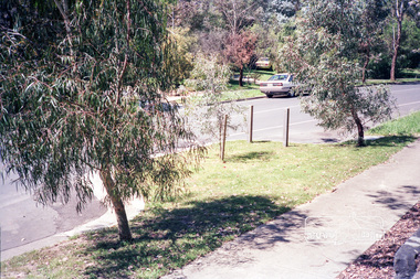
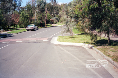
Photograph, Valonia Drive, Eltham, c.October 1990, 15/10/1990
Chicane outside number 76. Prints were originally housed in a photo print envelope with note indicating they were taken 15 October 1990.Roll of 35mm colour negative film, 6 of 7 stripsKodak Gold 100-2 5095infrastructure, roadworks - gutters, valonia drive, shire of eltham, streets -
 Eltham District Historical Society Inc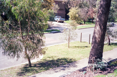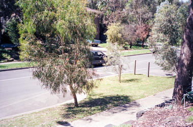
Photograph, Valonia Drive, Eltham, c.October 1990, 15/10/1990
Chicane outside number 76. Prints were originally housed in a photo print envelope with note indicating they were taken 15 October 1990.Roll of 35mm colour negative film, 6 of 7 stripsKodak Gold 100-2 5095infrastructure, roadworks - gutters, valonia drive, shire of eltham, streets -
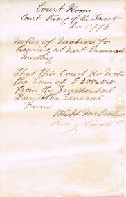 Bendigo Historical Society Inc.
Document - ANCIENT ORDER OF FORESTERS NO. 3770 COLLECTION: CORRESPONDENCE
Notice of motion for hearing at next Summer Meeting that this Court do vote the Sum of £300-0-0 from the Incidental Fund to the General Fund. Dated December 13/76 and signed W Nicholas and Rick Coath.societies, aof, correspondence, ancient order of foresters no. 3770 collection - correspondence, court king of the forest, w nicholas, rick coath -
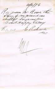 Bendigo Historical Society Inc.
Document - ANCIENT ORDER OF FORESTERS NO 3770 COLLECTION: RECEIPT
Receipt written on a piece of paper and dated 30/11/76. Rec. from Mr. Rowe the Sum of one pound one shilling ? Fees Court Happy Valley. £1:1:0 E. Richards, Sec.societies, aof, correspondence, ancient order of foresters no 3770 collection - receipt, mr rowe, court happy valley, e richards -
 Bacchus Marsh & District Historical Society
Map, Gorrockburkchap Parish Map, County of Grant c.1915
The parish of Gorrockburkchap (sometimes spelled Gorrockburkghap) lies to the west and south west of the township of Bacchus Marsh. The locality of Rowsley is situated within this parish area.A single page paper map showing the parish plan for Gorrockburkchap in the County of Grant. The map is pasted into a bound volume containing 76 maps or plans in total. High resolution digital image stored on BMDHS computer network. gorrockburkchap parish maps, rowsley victoria maps -
 Bacchus Marsh & District Historical Society
Map, Gorrockburkchap Parish Map, County of Grant
The parish of Gorrockburkchap (sometimes spelled Gorrockburkghap) lies to the west and south west of the township of Bacchus Marsh. The locality of Rowsley is situated within this parish area.A single page paper map showing the parish plan for Gorrockburkchap in the County of Grant. The map is pasted into a bound volume containing 76 maps or plans in total. High resolution digital image stored on BMDHS computer network. gorrockburkchap parish maps, rowsley victoria maps -
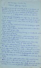 Melbourne Tram Museum
Document, Melbourne Tramway & Omnibus Co - abstracts of Rules for Gripmen
Copy of a document from an original source, handwritten and partly typed. Details the 104 Rules that applied to the Melbourne Tramway and Omnibus Company grip men for cable tram operations. Gives rules for their personal behaviour, duties, operations, management of passengers, shunting, use of the gong, not converse with passengers, what to do if a flock of sheep on the line, use of the grip, stop and starting of the tram (known as a train), care of the rope, end of the shift duties and knowledge of the Rules and Regulations.Yields information about the rules that Melbourne cable tram grip men operated by.Set of two blue foolscap handwritten sheets consisting of five sheets each (Rules 1 to 76) and one typed sheet (Rules 77 to 104) titled Melbourne Tramway & Omnibus Co - abstracts of Rules for Gripmentramways, trams, cable trams, grip men, rules, mtoco -
 4th/19th Prince of Wales's Light Horse Regiment Unit History Room
Antenna, ALWA 26-76 MHz, 1970's
Adjustable dipole antenna for use with RT524 & RT841/PRC77. Frequency range 26 to 76 MHz. Consists of an antenna coupler with adjustable wire elements, 2 weighted cords, an anchor stake, and instruction plate, all in a webbing satchel. antenna, radio, signals -
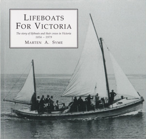 Warrnambool and District Historical Society Inc.
Book, Marten Syme, Lifeboats For Victoria, 2001
History of lifeboats and their crews in Victoria from 1856 to 1879This is a paper back book with a plasticized cover. It has 76 pages and an index. The cover is olive-green in colour with images of a life boat and a lifeboat service certificate. The book contains printed material, diagrams, maps, photographs and other illustrations.non-fictionHistory of lifeboats and their crews in Victoria from 1856 to 1879lifeboats, shipwrecks, port fairy lifeboats, warrnambool lifeboats, history of warrnambool -
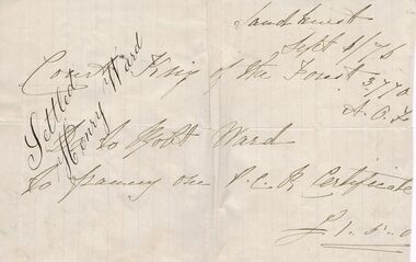 Bendigo Historical Society Inc.
Document - ANCIENT ORDER OF FORESTERS NO 3770 COLLECTION: ACCOUNT/RECEIPT
Account/Receipt written pale green paper and dated Sept 6/76. Court King of the Forest 3770 A.O.F. To Robt. Ward to framing one P.C.B. Certificate £1:5:0. Signed Settled Henry Ward/societies, aof, correspondence, ancient order of foresters no 3770 collection - account/receipt, court king of the forest, robt ward, henry ward -
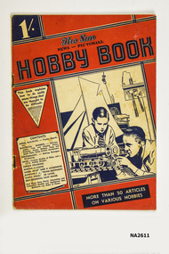 Whitehorse Historical Society Inc.
Book, The Sun News-Pictorial Hobby Book, 1936 - 1937
A4 size book bound with paper covers and centre stapled (metal). Front cover printed with blue and red design on cream. Top left hand corner ha '1/-' denoting the cost of one shilling. 76 Pagesbooks, technical -
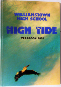 Williamstown High School
High Tide 2007, Williamstown High School Year Book 2007
A4 sized coloured cardboard book of 76 pages. This book represents the 2007 Williamstown High School year. It contains reports from all departments, sports results, student work a and many photographs, some in gfull colour.williamstown high school, 2007, high tide, year books -
 Bacchus Marsh & District Historical Society
Map, Plan of part of the road district of Bacchus Marsh circa 1856-1862
Local government in much of Victoria including the Bacchus Marsh area began with the formation of 'local committees'. These local committees could make representations to a Central Road Board regarding plans for road construction. Road construction and maintenance were seen as the essential tasks of these early local government authorities. By 1856 the local committee in Bacchus Marsh was constituted as the Bacchus Marsh Road District. This entity continued until 1862 when the name changed to the Bacchus Marsh and Maddingley Road District. This new entity lasted until 1871 when the local government authority in accordance with new statewide legislation became known as the Shire of Bacchus Marsh. The title of this plan being a plan of 'a portion of the road district of Bacchus Marsh' suggests that the plan was produced sometime between 1856 and 1862. The main purpose of this map was to shown the irrigable land in the district and the sources from which water for irrigation could be drawn. Bacchus Marsh was an early irrigation district in Victoria. Irrigation trusts were formed in the 1880s and 1890s to manage irrigation districts. But this was the culmination of many years of earlier attempts to construct irrigation systems in the Bacchus Marsh area and create a system to manage irrigation more broadly. This map dating from around 1856-1862 is an important cartographic document which provides evidence of how the early planning for irrigation was developing in the Bacchus Marsh region.A single page paper map showing a plan of part of the road district of Bacchus Marsh. The map is pasted into a bound volume containing 76 maps or plans in total. High resolution digital image stored on BMDHS computer network. bacchus marsh victoria maps, bacchus marsh road district, local government, road districts, irrigation -
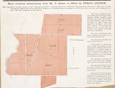 Bacchus Marsh & District Historical Society
Map, Bullengarook Estate Property Sale. 1911
Bullengarook is a locality located 19 kilometers north of Bacchus Marsh. Pastoral leases for European colonists were granted to people for this area from around the 1840s.The Bullengarook Estate was part of these early pastoral holdings. By the 1900s the property had been owned by the Skene family for a number of years. In early 1911 the property then consisting of 300 acres and the homestead upon it was offered for sale in one lot. It appears however that the sale of the property did not go through in 1911. It was later leased by Thomas Skene to a Mr Coutts in 1915 and ultimately and at a later stage the property was sold by the Skene family.A single page paper map showing land allotments for sale from the Bullengarook Estate. The map is pasted into a bound volume containing 76 maps or plans in total. High resolution digital image stored on BMDHS computer network. land sales bacchus marsh, bullengarook land sales, bullengarook estate, bullengarook vic history -
 Bendigo Military Museum
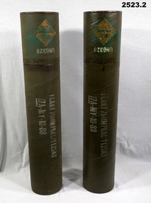
Container - SHELL CASES, Post 1960
.1) Shell casing cylinder, heavy cardboard & metal construction, green. One end is a lid which slides on firmly. .2) Same as .1) above. Each one has a diamond shaped sticker with the word Explosive on..1) “1 CART 76 MM PRAC / TL 25A3, 17A-MY-10-88” .2) Same as .1) abovecontainers, metalcraft, 76 -
 Bendigo Historical Society Inc.
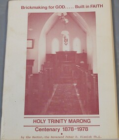
Book - Aileen and John Ellison Collection: Holy Trinity Marong - Centenary 1878-1978
The foundation stone of the Holy Trinity Church in Marong was laid on 10/4/1878 by the Anglican Bishop of Melbourne.A sixty pages book. "Brickmaking for God, Built in Faith", Holy Trinity Marong Centenary 1878-1978. Written by the rector, the Reverend Peter D. Kissick Th.L. A picture of the inside of the church is on the front cover.Inside the front cover in blue pen: John Ellison In appreciation of your help, signed by Peter Kissick 16/04/76marong, holy trinity centenary -
Moorabbin Air Museum
Manual (Item) - Demon To Vampire
Description: 76 pages. Published by Hollingstead International Inc. Published on unknown date. Engineering Design Manual for Hollingstead Boxmount Avionic Support Structures Level of Importance: World. -
 Williamstown High School
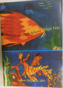
High tide 2003
Williamstown High School year book for the 2003 school year. Coloured card card cover with student work, 76 pages, illustrated, some colour. Contains student work, sports report, school news and some class photographs.williamstown high school, year books, high tide, 2003 -
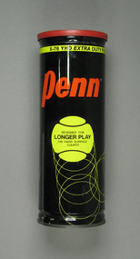 Tennis Australia
Ball container, Circa 1975
An empty, unsealed Penn 'X-76 Extra Duty High Visibility' tennis ball can. Missing metal ring-pull seal lid and balls. Has Wilson-branded plastic reclosure lid. Materials: Metal, Ink, Plastictennis -
 Bacchus Marsh & District Historical Society
Map, Bacchus Marsh Tuesday 23rd Oct. 1888, Lodge & Dunn's Paddocks 1888. Business and Mansion Sites
This map was created as a plan for an auction of land close to the Bacchus Marsh Railway Station. The auction took place on 23 October 1888. 102 allotments of land from an area known as Lodge and Dunn's paddocks was offered for sale. The auction was conducted by auctioneers based in Melbourne and was advertised in Melbourne newspapers as well as in the Bacchus Marsh Express newspaper. The auction plan contains a range of details including the selling agents, Munro and Baillieu; W.P. Lockhart; and John Turner, all of Melbourne, deposit terms for purchases, price of railway passes for a return trip from Melbourne to Bacchus Marsh of 1 shilling, and a description of the land as having 'magnificent views and perfect drainage'. A single page paper map showing allotments of land for sale along the Parwan Road in Maddingley. The map is pasted into a bound volume containing 76 maps or plans in total. High resolution digital image stored on BMDHS computer network. At bottom on left side: 'Harston & Co. Lith, Melb.'land sales bacchus marsh, land sales maddingley, bacchus marsh victoria maps, maddingley victoria maps -
 Bacchus Marsh & District Historical Society
Map, Bacchus Marsh Suburban Allotments Parwan Road Lodge & Dunn's Paddocks 1888
This map was created as a plan for an auction of land close to the Bacchus Marsh Railway Station. The auction took place on 23 October 1888. 102 allotments of land from an area known as Lodge and Dunn's paddocks was offered for sale. A single page paper map showing allotments of land for sale along the Parwan Road in Maddingley. The map is pasted into a bound volume containing 76 maps or plans in total. High resolution digital image stored on BMDHS computer network. land sales bacchus marsh, land sales maddingley, bacchus marsh victoria maps, maddingley victoria maps -
 Bacchus Marsh & District Historical Society
Map, Maddingley Township, Parish of Parwan, 1880s
This map is dated Sept. 6th 1856. However places in the township of Maddingley which did not appear until the late 1880s such as the Bacchus Marsh Railway Station and line are shown on this map in their correct locations. This suggests the map has been derived from an earlier map. An earlier date of 1843 with a surveyor's name preceding it can also be seen on the map. The map is important because it indicates the location and dimensions of early but now discontinued use of land such as the showgrounds and police paddock and a site reserved for the Church of England which was not ultimately used for a permanent church. A single page paper map showing land allotments, streets, rivers, creeks, park lands, the railway line and Bacchus Marsh railway station in the township of Maddingley. The map is pasted into a bound volume containing 76 maps or plans in total. Bottom of Map: Surveyor-General's Office, Melbourne, Sept 6th, 1856bacchus marsh victoria maps, maddingley victoria maps, land use, maddingley victoria history