Showing 488 items matching "north avenue"
-
 Ringwood and District Historical Society
Photographs, 1979-80 MMBW pipe line project at Hubbard Reserve, North Ringwood � Manhole behind 29 Burlock Avenue
Part of a 43-photo record of the MMBW�s engineering feat in drilling a 12 inch pipe line up to 40 feet deep through rock hardened by volcanic action associated with geological fault that occurs along the line. The work took place from October 1979 to May 1980 on the southern boundary of Hubbard Reserve, North Ringwood. The collection was presented to the Ringwood Historical Research Group by J Clarke on 9th June 1980.E566 N5 13 May 1980 A43 Manhole behind 29 Burlock Avenue, 38 feet deep. Debbie place is on the far right. -
 Ringwood and District Historical Society
Photographs, 1979-80 MMBW pipe line project at Hubbard Reserve, North Ringwood � Boring mole pit
Part of a 43-photo record of the MMBW�s engineering feat in drilling a 12 inch pipe line up to 40 feet deep through rock hardened by volcanic action associated with geological fault that occurs along the line. The work took place from October 1979 to May 1980 on the southern boundary of Hubbard Reserve, North Ringwood. The collection was presented to the Ringwood Historical Research Group by J Clarke on 9th June 1980.E561 N14 3 March 1980 A43 View west behind No. 29 Burlock Avenue, showing gantry over manhole 38 feet deep. -
 Ringwood and District Historical Society
Photographs, 1979-80 MMBW pipe line project at Hubbard Reserve, North Ringwood � The work on sewer line from 29-39 Burlock Avenue
Part of a 43-photo record of the MMBW�s engineering feat in drilling a 12 inch pipe line up to 40 feet deep through rock hardened by volcanic action associated with geological fault that occurs along the line. The work took place from October 1979 to May 1980 on the southern boundary of Hubbard Reserve, North Ringwood. The collection was presented to the Ringwood Historical Research Group by J Clarke on 9th June 1980.E561 N11 3 March 1980 A43 The work on sewer line from 29-39 Burlock Avenue. Lundy-Clarke's place on sky-line. -
 Ringwood and District Historical Society
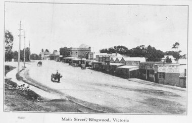
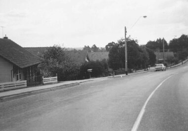
Photograph, Maroondah Highway Central, Ringwood. Main Street, looking west from Warrandyte Rd, c1924
Black and white photograph (2 copies- 1 large, 2 small) Typed below large photograph: "Main St looking west from Warrandyte Rd, c1924." Typed on back of one small photograph: "Coped from a circular for Mountain View Estate, J. Press, vendor, Second Av. Kew. In Mullum Rd, 90 yds from Oban Rd. Press, Rangeview & Mountview Avenues. Winnington just completed. 1924." -
 Ringwood and District Historical Society
Photographs, 1979-80 MMBW pipe line project at Hubbard Reserve, North Ringwood � Line of tunnel shafts behind 29-39 Burlock Avenue
Part of a 43-photo record of the MMBW�s engineering feat in drilling a 12 inch pipe line up to 40 feet deep through rock hardened by volcanic action associated with geological fault that occurs along the line. The work took place from October 1979 to May 1980 on the southern boundary of Hubbard Reserve, North Ringwood. The collection was presented to the Ringwood Historical Research Group by J Clarke on 9th June 1980.E561 N10 Feb 1980 A43 Line of tunnel shafts behind 29-39 Burlock Avenue. Horizontal gantry was above the manhole in the corner of No. 29. -
 Ringwood and District Historical Society
Photographs, 1979-80 MMBW pipe line project at Hubbard Reserve, North Ringwood � First hole west of bore hole at 39 Burlock Avenue
Part of a 43-photo record of the MMBW�s engineering feat in drilling a 12 inch pipe line up to 40 feet deep through rock hardened by volcanic action associated with geological fault that occurs along the line. The work took place from October 1979 to May 1980 on the southern boundary of Hubbard Reserve, North Ringwood. The collection was presented to the Ringwood Historical Research Group by J Clarke on 9th June 1980.E561 N9 Feb 1980 A43 First hole west of bore hole at 39 Burlock Avenue -
 Ringwood and District Historical Society
Photograph, Greenwood Park Kindergarten, Greenwood Avenue, Ringwood - 1963, 1963
Greenwood Kinder, 1963Written on back of photograph, "Greenwood Kinder, 1963". -
 Ringwood and District Historical Society
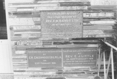
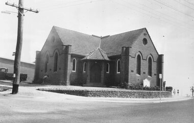
Photograph, Foundation plaques at the Methodist Church in Greenwood Avenue, Ringwood in 1973, 1973
Foundation plaques at the Methodist Church in Greenwood Avenue in 1973 +Additional Keywords: Rev RM Brandt / EW Greenwood / Rev EJ LittleWritten on back of photograph, "22/7/73 Meth. Church C/R Greenwood Av. 2 bot. (bottom) stones are from old church same site." Plaque laid by Rev RM Brandt on 18th May 1963, plaque laid by EW Greenwood MLA on 23rd February 1918 and third one laid by Rev EJ Little on 23rd February 1918. -
 Ringwood and District Historical Society
Photographs, Maroondah Highway, Ringwood, corner of Kalinda Road and Cutts Avenue in 1999
-
 Ringwood and District Historical Society
Photograph, South side of Bedford Road, Ringwood East, taken from outside shops on the corner of Illoura Avenue - 1/9/1974
Written on back of photograph, "Bedford Rd. looking at south side towards east from outside shops cnr. Illoura Ave. (As in brochure)" -
 Ringwood and District Historical Society
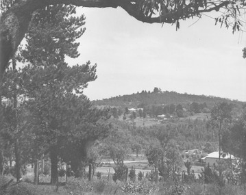
Photograph, View from Herman Pump's orchard, Heathmont near Royal Avenue. Looking towards Bedford Rd. and Ringwood (undated)
Typed below photograph, "View from Herman Pump's orchard, Heathmont near Royal Avenue. Looking towards Bedford Rd. and Ringwood. Loughnans Hill in background to left of centre." -
 Ringwood and District Historical Society
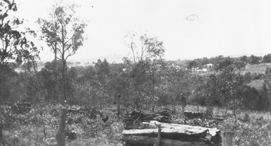
Photograph, Ringwood Birdseye - Looking towards Ringwood from later site of Civic Centre in Braeside Avenue, Ringwood East
Typed below photograph, "Looking towards Ringwood from present site of Civic Centre. Old Catholic Church which stood on Maroondah Hwy. and Mt. Dandenong Rd. intersection can be seen on right. Maroondah Hwy. can be seen where it goes past lake, also station masters residence, and houses in Pitt St. and Bedford Rd." -
 Ringwood and District Historical Society
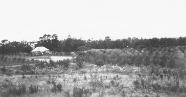
Photograph, Herman Pump's orchard and home Heathmont - 1923 - in vicinity of Royal Avenue. House on Canterbury Road, later site of Uniting Church
Black and white photograph of orchard. House in top left of photograph.Typed on backing sheet below photograph, "Herman Pump's orchard and home Heathmont - 1923 - in vicinity of Royal Avenue. House on Canterbury Road, now site of Uniting Church". -
 Ringwood and District Historical Society
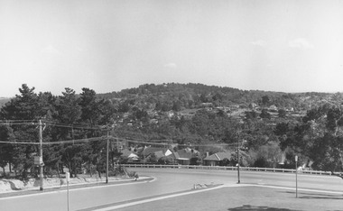
Photograph, View from Civic Centre, Braeside Avenue, overlooking Maroondah Highway towards Loughnan's Hill - 1973
Black and white photograph looking towards T-intersection towards housing and trees on hill. -
 Ringwood and District Historical Society
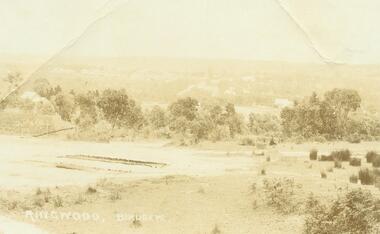
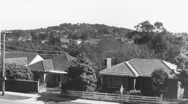
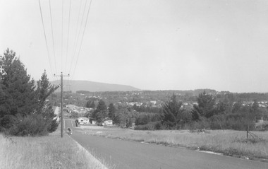
Photograph, View from Maroondah Highway opposite Braeside Avenue towards Loughnan's Hill - 1973
View from Maroondah Highway opposite Braeside Avenue towards Loughnan's Hill - 1973. -
 Ringwood and District Historical Society
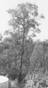
Photograph, Red box tree at rear of 39 Burlock Avenue (no date)
Written on back of photograph, "Paul's shot of the big box tree from the top of the shed". Also, "Red box tree at rear of 39 Burlock Avenue". -
 Ringwood and District Historical Society
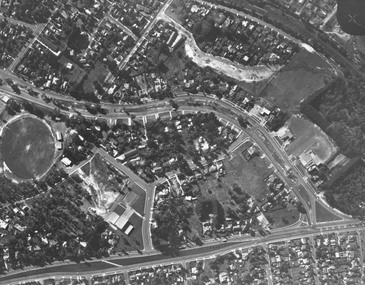
Photograph, Aerial view showing East Ringwood oval, Mount Dandenong Road, and Civic Centre, Braeside Avenue/Maroondah Hwy, c.1970
Aerial view showing East Ringwood oval, Mount Dandenong Road, and Civic Centre, Braeside Avenue/Maroondah Hwy, c.1970. -
 Ringwood and District Historical Society
Photograph, Two photos of Panfield Estate, owned by Vic Hunter sold by Miles & Co. - view from Panfield Avenue looking to Mullum Road, c.1963-65
Two photos - various inscriptions. "This (first) photo is RHS partner of V15" "Panfield Estate 1960. Panfield Ave. to Mullum Rd." "1965. Panfield Estate owned by Vic Hunter sold by Miles & Co." and second photo has written below photograph,"This photo is LHS partner of V11". Written on backing sheet,"Panfield Estate looking to Mullum Rd, 1963". -
 Ringwood and District Historical Society
Photograph, View towards Loughnan's Hill overlooking Maroondah Hwy Ringwood from around Braeside Avenue area
Typed below one photograph, "View towards Loughnan's Hill from Harrison St. 1946". Written below another copy, "Loughnan Hill from Andrew St. 1946". both incorrect - view overlooking Maroondah Hwy from around Braeside Avenue area. -
 Ringwood and District Historical Society
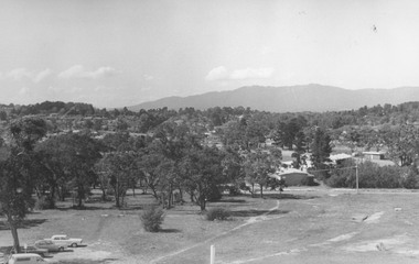
Photograph, Series of photographs taken from roof of Civic Centre in Braeside Avenue Ringwood East, 1973. (14 images)
Written on backing sheet, "Looking from roof of Civic Centre across sports grounds, Ringwood East, 1973". -
 Ringwood and District Historical Society
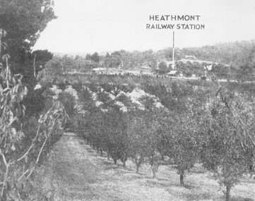
Photograph, View of what was Heathmont township taken from about Royal Avenue looking at Mr. Herman Pump's orchard. Old bridge over Canterbury Road can be seen on left
Typed below photograph, "View of what was Heathmont township taken from about Royal Avenue looking at Mr. Herman Pump's orchard. Old bridge over Canterbury Road can be seen on left." -
 Ringwood and District Historical Society
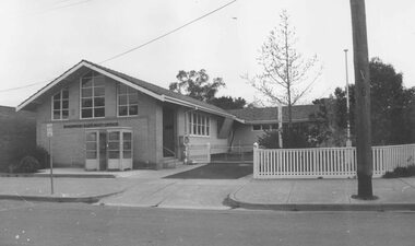
Photograph, Ringwood East Post Office, Railway Avenue cnr Laurence Grove, 1973
Ringwood East Post Office, Railway Avenue cnr Laurence Grove, 1973. -
 Ringwood and District Historical Society
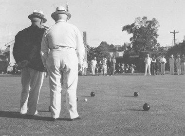
Photograph, Ringwood Bowling Club- Miles Avenue, c1950's
Black and white photograph.Ringwood Bowls Club, Miles Avenue, c1950. Bowlers on green. -
 Ringwood and District Historical Society
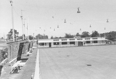
Photograph, Ringwood Bowling Club- New clubrooms, 1972
Black and white photograph"Written on back of photograph" Bowling green and new clubrooms. 22.11.72. Miles Avenue site. Clubrooms were built in 1968 after the old clubrooms were destroyed by fire. -
 Ringwood and District Historical Society
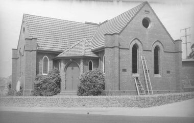
Photograph, Methodist Church, cnr Station Street and Greenwood Avenue, Ringwood - 1st step in demolition of windows - 1963
Demolishing old Methodist Church Cnr. Station St. and Greenwood Ave. 1963".Written on backing sheet, "1st step in demolition of windows" -
 Ringwood and District Historical Society
Photograph, Methodist Church, cnr Station Street and Greenwood Avenue, Ringwood on first day of demolition - 1963
Written on backing sheet, "Rwd. Meth. on 1st day of demolition. -
 Glen Eira Historical Society
Album - Album page, Normanby Road, Circa 1972
This photograph is part of the Caulfield Historical Album 1972. This album was created in approximately 1972 as part of a project by the Caulfield Historical Society to assist in identifying buildings worthy of preservation. The album is related to a Survey the Caulfield Historical Society developed in collaboration with the National Trust of Australia (Victoria) and Caulfield City Council to identify historic buildings within the City of Caulfield that warranted the protection of a National Trust Classification. Principal photographer thought to be Trevor Hart, member of Caulfield Historical Society. Most photographs were taken between 1966-1972 with a small number of photographs being older and from unknown sources. All photographs are black and white except where stated, with 386 photographs over 198 pages. From: Glen Eira Heritage Management Plan (1996) - Vol 2 by Andrew Ward and Associates The widening of Dandenong Road during the late 1980's has resulted in the destruction of the houses in the path of the roadworks and the construction of a high fence serving as a visual barrier between that thoroughfare and the remaining houses. Where comparatively large villas once stood on spacious allotments, only "Wisteria" survives at No. 135 Normanby Road. Adopting forms and timber enrichment characteristic of the American Queen Anne style, it has this in common with the largely reconstructed timber villa at no. 11 Normanby Avenue and to a lesser extent, 746 Inkerman Road. Normanby Road retains its comparatively opulent Edwardian character in a mature landscaped setting with spacious gardens and mature planes parallel with the railway reserve which, on account of the low lying ground in its vicinity has a high embankment commencing on the alignment of Malvern Grove and continuing to Caulfield Station. The earliest villas are Edwardian. Page 148 of Photograph Album with one landscape photograph of a house on Normanby Road (not Street).Handwritten: Normanby St [top right] / 148 [bottom right]trevor hart, verandah, porch, bull nosed verandah, tower house, tower, stone fence, normanby road, wisteria, american queen anne style, queen anne style, 1890's, mayfield grove, normanby street, timber houses, caulfield north, house names, edwardian, edwardian style, gardens -
 Glen Eira Historical Society
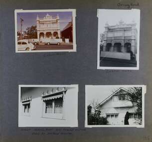
Album - Album page, Orrong Road, Circa 1972
This photograph is part of the Caulfield Historical Album 1972. This album was created in approximately 1972 as part of a project by the Caulfield Historical Society to assist in identifying buildings worthy of preservation. The album is related to a Survey the Caulfield Historical Society developed in collaboration with the National Trust of Australia (Victoria) and Caulfield City Council to identify historic buildings within the City of Caulfield that warranted the protection of a National Trust Classification. Principal photographer thought to be Trevor Hart, member of Caulfield Historical Society. Most photographs were taken between 1966-1972 with a small number of photographs being older and from unknown sources. All photographs are black and white except where stated, with 386 photographs over 198 pages.Victorian Heritage Database https://vhd.heritagecouncil.vic.gov.au/places/35576 No. 70 Orrong Road is important as an exceptionally ornate Boom style villa residence in the terraced form and in this respect is rare in Caulfield. Its architectural value is enhanced by its intact state and by the manner in which its bold architectural expression is carried through into the hallway and staircase. Victorian Heritage Database - National Trust local significance 284 Orrong Road Caulfield https://vhd.heritagecouncil.vic.gov.au/places/65700 A house designed by Harold Desbrowe Annear in 1917 and believed to have been the first "all electric" house in Melbourne. It has been extensively altered.Page 164 - four photographs of 2 different houses on Orrong Road. The top left photo is in colour while the others are in black and white.Handwritten: Orrong Road [top right] / Lisborn House [ (ed. correct name is LISBON HOUSE), under top left photo] / Lisborn House [under top right photo] / [under bottom right photo] / CORNER ORRONG ROAD AND PEARSON AVENUE / HOUSE BY DESBROWE ANNEAR [under bottom left photo] / 164 [bottom right]trevor hart, orrong road, lisbon house, lisborn house, elsternwick, pearson grove, st kilda east, caulfield north, terrace houses, cast iron work, verandahs, balconies, parapets, arches, cars, streetscapes, attic houses, desbrowe annear -
 Glen Eira Historical Society
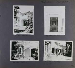
Album - Album page, Rose Craddock, Rose Craddock Avenue, Circa 1972
... 4-10 Craddock Avenue, Caulfield North, Melbourne, Victoria... Avenue Caulfield North https://vhd.heritagecouncil.vic.gov.au ...This photograph is part of the Caulfield Historical Album 1972. This album was created in approximately 1972 as part of a project by the Caulfield Historical Society to assist in identifying buildings worthy of preservation. The album is related to a Survey the Caulfield Historical Society developed in collaboration with the National Trust of Australia (Victoria) and Caulfield City Council to identify historic buildings within the City of Caulfield that warranted the protection of a National Trust Classification. Principal photographer thought to be Trevor Hart, member of Caulfield Historical Society. Most photographs were taken between 1966-1972 with a small number of photographs being older and from unknown sources. All photographs are black and white except where stated, with 386 photographs over 198 pages. From Victorian Heritage Database citation for H0589 Rosecraddock 4-10 Craddock Avenue and 2-8 Keverell CAULFIELD NORTH https://vhd.heritagecouncil.vic.gov.au/places/35279 as at (30/10/2020) "Rosecraddock" is regionally important as a surviving large villa from the early Victorian (1850's) period, offering insight into the lifestyles of the privileged in Caulfield at that time. Its importance is enhanced through its long association with the Langdon family and, in particular, Henry Joseph Langdon, founder of H.J. Langdon and Company, China merchants. Victorian Heritage Database HO16 Rosecraddock, 2-8 Keverell Road & 4-10 Craddock Avenue Caulfield North https://vhd.heritagecouncil.vic.gov.au/places/35279 (as of 17/02/2021) A single storeyed stuccoed villa with west facing facade consisting of a parapeted and recessed central section with hipped slate roof and timber posted verandah with cast iron lace. Projecting pavilions have bayed windows and a secondary wing runs north with angled corners and prominent chimney stack. The front entrance is situated at the north end of the central section and is given emphasis by a small hip roof and false pediment to the verandah. Outbuildings include the timber stables with characteristic hay loft gablet and fretted barges to the south-east. Rear additions in brick and timber are of an early date and utilitarian in character. Also see https://vhd.heritagecouncil.vic.gov.au/places/277 for Significance Statement for the H0589 Victorian Heritage Register listing.Page 174 of Photograph Album with four photographs of Rose Craddock.Handwritten: "Rose Craddock" Rose Craddock Ave. top right] / Neg 197 Nov 1972 [under top left photo] / Neg 209 Nov 1972 [under top right photo] / Neg 196 Nov 1972 [under bottom left photo] / Neg 195 198 Nov 1972 [under bottom right photo] / 174 [bottom right]trevor hart, chimneys, porch, rose craddock, rosecraddock, ringwood, 1850's, henry joseph langdon, h.j. langdon, h.j. langdon and company, china merchants, rosecraddock place, slate roof, return verandah, decorative brackets, keverell road, caulfield north, early victorian style, protruding bay windows, cast iron work, rendered walls, entrances, mansions, craddock avenue -
 Glen Eira Historical Society
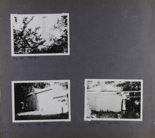
Album - Album page, Rose Craddock, Rose Craddock Avenue, Circa 1972
... CRADDOCK AVENUE CAULFIELD NORTH - Victorian Heritage Register ...This photograph is part of the Caulfield Historical Album 1972. This album was created in approximately 1972 as part of a project by the Caulfield Historical Society to assist in identifying buildings worthy of preservation. The album is related to a Survey the Caulfield Historical Society developed in collaboration with the National Trust of Australia (Victoria) and Caulfield City Council to identify historic buildings within the City of Caulfield that warranted the protection of a National Trust Classification. Principal photographer thought to be Trevor Hart, member of Caulfield Historical Society. Most photographs were taken between 1966-1972 with a small number of photographs being older and from unknown sources. All photographs are black and white except where stated, with 386 photographs over 198 pages. From Victorian Heritage Database citation for Rosecraddock https://vhd.heritagecouncil.vic.gov.au/places/35279 as at (30/10/2020) City of Glen Eira Heritage Listing HO16 "Rosecraddock" is regionally important as a surviving large villa from the early Victorian (1850's) period, offering insight into the lifestyles of the privileged in Caulfield at that time. Its importance is enhanced through its long association with the Langdon family and, in particular, Henry Joseph Langdon, founder of H.J. Langdon and Company, China merchants.There is a separate statement of significance at https://vhd.heritagecouncil.vic.gov.au/places/277 for H0589 Rosecraddock 2-8 KEVERELL ROAD and 4-10 CRADDOCK AVENUE CAULFIELD NORTH - Victorian Heritage RegisterPage 175 of Photograph Album with three photographs of Rose Craddock.Handwritten: Neg 190 Nov 1972 [under top left photo] / Neg 207 Nov 1972 [under bottom left photo] / Neg 191 Nov 1972 [under bottom right photo] / 175 [bottom left]trevor hart, chimneys, porch, rose craddock, rosecraddock, 1850's, henry joseph langdon, h.j. langdon, h.j. langdon and company, china merchants, rosecraddock place, slate roof, return verandah, decorative brackets, cast iron lacework, keverell road, caulfield north, early victorian style, mansions, protruding bay windows, cast iron work, outbuildings, craddock avenue, gardens