Showing 25273 items
matching north-coombes
-
 Ringwood and District Historical Society
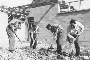
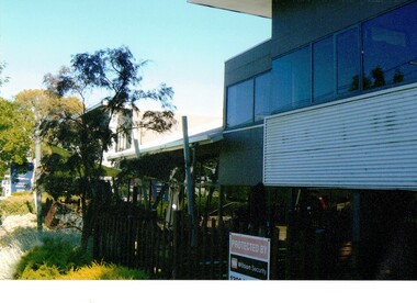
Photograph, North Ringwood Scout Hall - men at work on construction (Undated)
Written on back of photograph, "North Ringwood Scout Hall". [No date]. -
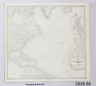 Flagstaff Hill Maritime Museum and Village
Document - Navigation Chart, North Atlantic Ocean
British Admiralty Navigation Chart - North Atlantic Oceanwarrnambool, shipwrecked-coast, flagstaff-hill, flagstaff-hill-maritime-museum, maritime-museum, shipwreck-coast, flagstaff-hill-maritime-village, shipwrecked-artefact, navigation chart, british admiralty navigation chart, british admiralty, north atlantic ocean -
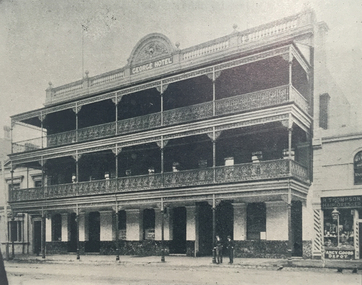 Ballarat Heritage Services
Photograph, George Hotel, Lydiard Street North, Ballarat, c1900
Originally called the George Inn, this hotel was established in 1853.Three storey hotel in Lydiard Street North, Ballaratballarat, george hotel, lydiard street north -
 Kew Historical Society Inc
Photograph, Floods in North Kew, 1934
Living with natural processes was frequently a challenge to early European settlers and later residents of what was in the 1850s administered by the Borondara Road Board. This was compounded by the area being bounded on three sides by rivers (Yarra River, Koonung Creek and Gardiner's Creek). In 1849, the historian James Bonwick recorded that "our district [Kew] suffered considerably. Mr Wade speaks of 80 acres, out of 100 acres of his cultivated paddock, covered by water." Newspapers continued to describe major flooding in Kew in 1863, 1869, 1878, 1880, 1889, 1891, 1916 and 1934. While the construction of the Upper Yarra dam in 1957 reduced the levels of flowing downstream, local and riverine floods continue.The Kew Historical Society's pictures and map collections testify to the impact of flooding in the district. They have historical importance in documenting the extent of flooding in the district and its affects on homes, services and recreation. Numerous photographs record flooding throughout the Twentieth Century.Floods in North Kew, 1934. Vicinity of Willsmere Park.floods (kew) -
 Stawell Historical Society Inc
Map, Parish of Stawell, North Ward & Big Hill etc
Shows Newington Co, Moonlight Co, St George Co, Victoria Co, Galatea Co Shows Tramline over Big Hill, Leviathan Co, Parish of Stawell, North Ward & Big Hill etcstawell -
Stawell Historical Society Inc
Map, Plans of Office Buildings, North Western Woollen Mills, 1941
Plans of Office Buildings, North Western Woollen Millsstawell, manufacture -
 Ballarat Heritage Services
Photograph - house, Clare Gervasoni, House at 10 Raglan Street North, Ballarat, 30/01/2007
At one time this house was owned by collector of Aboriginal artefact Dr Sydney Pern.Weatehrboard house at 10 Raglan Street North, Ballarat. 10 raglan st north ballarat, sydney pern, architecture, weatherboard house' -
 Whitehorse Historical Society Inc.
Photograph - Coloured Photograph, Blackburn North Baptist Church
Two coloured photographs of Blackburn North Baptist Church.blackburn north baptist church, blackburn north -
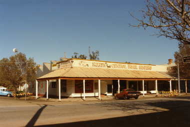 Charlton Golden Grains Museum Inc
Photograph, North Central Panel Beaters 1987, c.1987
North Central Panel Beaters 1987, formerly Charlton Motors Pty Ltd Service StationColour photograph showing North Central Panel Beaters building on the corner of High and Armstrong Sts. Red car in front of shop on High St, blue & white vehicle on LH side on Armstrong St. Sign attached to verandah showing St Arnaud 42. Signage on front window says Mechanical Repairs, Automotive Service Centre, Ph S?. 1389. Safety tape around tree on LH side of photo and barricades on the High St kerb at the end of the verandah. Telstra tower visible in background.north central panel beaters, charlton motors, business, industry, armstrong street, charlton -
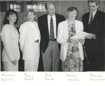 Lakes Entrance Historical Society
Photograph, Lakes Posat Newspaper, North Arm Foreshore and Estuary Plan, Lakes Entrance Victoria, 1/12/1996 12:00:00 AM
Black and white photograph taken at the launch of the North Arm Foreshore and Estuary Plan showing Marlene Battista DNRE, Jennifer North Friends of North Arm, Ian Smith Consultant, Margo Kerby Presidnet of FONA and Duncan Malcolm Shire Commissioner held at Shire Offices Lakes Entrance Victoriaenvironment, people, waterways -
Lakes Entrance Historical Society
Book, Landsmith Pty Ltd, North Arm Action Plan, 1996
This plan was formulated as a comprehensive guide for sustainable management of the waters and environment of the North Arm while providing recreational opportunities that are in balance with the environmental values of the North Arm and its catchment Lakenvironment, vegetation, recreation -
 Ballarat Tramway Museum
Postcard, ESCo tram north bound in Lydiard St North
Yields information about the corner of Sturt St and Lydiard St soon after the Ballarat Electric Tramway opened.Digital Image of and ESCo tram north bound in Lydiard St North, at the intersection with Sturt St. Shows the Ballarat Post Office and other buildings in Lydiard St. Note the centre poles the new tram tracks. Photo taken soon after opening as the destination sign is on the dash panel. There are a number of lines of dark brown piles of earth? Work still being undertaken. Titled "Post Office Ballarat". From the Facebook group of old time photographs of yesterday.trams, tramways, sturt st, lydiard st north, esco, postcards -
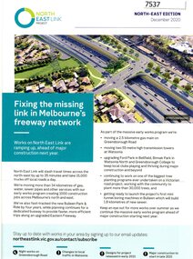 Greensborough Historical Society
Pamphlet - Newsletter, Victorian Government, Fixing the missing link in Melbourne's freeway network, 2020_12
An update on the North East Link Project, the North-East Edition December 2020 Large sheet folded twice. Colour illus. and map. 2 copies.north east link, western ring road -
 Federation University Historical Collection
Map, Wendouree (Alfredton and Ballarat North) Retail and Business Guide, 2005, 10/2005
Wendouree, Alfredton and Ballarat North Retail and business guide mapmap, guide, wendouree, alfredton, ballarat north -
Whitehorse Historical Society Inc.
Pamphlet, Blackburn North Primary School. Silver Anniversary, 1979
Brief history of Blackburn North Primary School, 1954 - 1979.blackburn north primary school., primary schools -
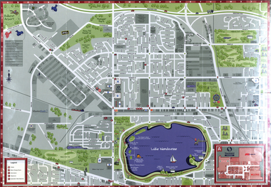
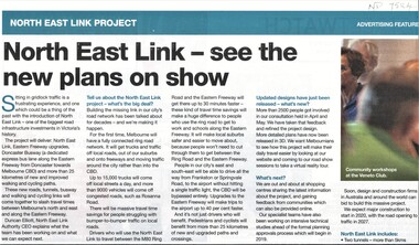 Whitehorse Historical Society Inc.
Article, North East Link Plan, 2018
Plans for the North East Link project can be viewed at northeastlink.vic.gov.auPlans for the North East Link project can be viewed at northeastlink.vic.gov.auPlans for the North East Link project can be viewed at northeastlink.vic.gov.aunorth east link, eastern freeway, bicycle paths -
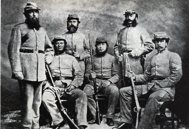 Ballarat Heritage Services
Photograph - Image, North Melbourne Rifle Regiment
A photograph of six uniformed men of the North Melbourne Rifle Regiment.north melbourne rifle regiment, volunteer regiments, rifles -
 Buninyong & District Historical Society
Photograph - Original Photograph, Geoff Little, Whykes Slaughterhouse, Durham Lead, unloading ramp from north, 1995
IndustryWhykes Slaughterhouse, Durham Lead, unloading ramp from north..buninyong, whykes, slaughterhouse, durham lead, butchers, unloading ramp -
 Kew Historical Society Inc
Photograph, Floods in North Kew, 1934
Living with natural processes was frequently a challenge to early European settlers and later residents of what was in the 1850s administered by the Borondara Road Board. This was compounded by the area being bounded on three sides by rivers (Yarra River, Koonung Creek and Gardiner's Creek). In 1849, the historian James Bonwick recorded that "our district [Kew] suffered considerably. Mr Wade speaks of 80 acres, out of 100 acres of his cultivated paddock, covered by water." Newspapers continued to describe major flooding in Kew in 1863, 1869, 1878, 1880, 1889, 1891, 1916 and 1934. While the construction of the Upper Yarra dam in 1957 reduced the levels of flowing downstream, local and riverine floods continue.The Kew Historical Society's pictures and map collections testify to the impact of flooding in the district. They have historical importance in documenting the extent of flooding in the district and its affects on homes, services and recreation. Numerous photographs record flooding throughout the Twentieth Century.Floods in North Kew, 1934. Flood near the lagoon (Billabong?)floods (kew) 1934, yarra river -
Whitehorse Historical Society Inc.
Letter - Correspondence, History of North Blackburn
A letter to Mr Rooney from K.A. Patterson, Nunawading and District Historical Society, enclosing their constitution.A letter to Mr Rooney from K.A. Patterson, Nunawading and District Historical Society, enclosing their constitution. The author speaks of references to hotels in Blackburn of interest to Rooney's history of North Blackburn, also talks about inspecting an old house in Almondsbury Court, Blackburn. Mrs Reynolds thought it was 120 years old but on inspection was found to be 80 - 100 years old.A letter to Mr Rooney from K.A. Patterson, Nunawading and District Historical Society, enclosing their constitution.nunawading and district historical society, rooney, keith, reynolds, (mrs), almondsbury court, blackburn. no 3 -
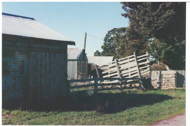
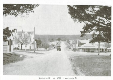 Buninyong & District Historical Society
Photograph - Photo of Original Photograph, Warrenheip / Learmonth intersection, looking north up Warrenheip, in 1958, 1995
historic streetscapeB/W photograph, Warrenheip / Learmonth intersection, looking north up Warrenheip, in 1958, Crown Hotel, corner store visible, truck with double layer load of cars heading north."Specially Produced For A.H. Dixon Learmonth St, from east, Buninyong 1543"buninyong, learmonth st., warrenheip st., intersection, crown hotel, corner store -
Lakes Entrance Historical Society
Album - Photograph, Judy Davies, Small album of North Arm Bridge Lakes Entrance Victoria, 2000 c
Small album containing fourteen colour photographs of construction of North Arm Bridge and sixteen colour photographs of North Arm Apex Park to Eastern Creek Bay Lakes Entrance Victoriaboats and boating, historic sites -
 Ringwood and District Historical Society
Photograph, No.90 Kubis Drive, North Ringwood 1982
Written on back of photograph, "21.4.82. No.90 Kubis Drive, North Ringwood." -
 Ringwood and District Historical Society
Photograph, Work on North Ringwood Senior Citizens' Rooms (undated)
2 PhotographsWritten on back of photographs, "Work on North Ringwood Senior Citizens' Rooms". -
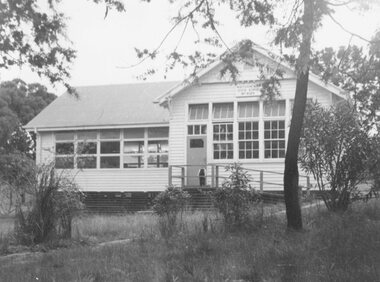 Ringwood and District Historical Society
Photograph, North Ringwood State School, Oban Road - 1962
Typed below photograph, "North Ringwood S.S. Oban Rd. 1962". -
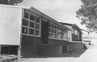 Ringwood and District Historical Society
Photograph, Additions to North Ringwood State School, Oban Road, 1973
Written on backing sheet, "Additions to North Ringwood State School, 1973". -
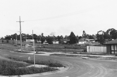 Ringwood and District Historical Society
Photograph, Westward view along Jull Road from corner of Carol Court, North Ringwood - 1981
Written on back of photograph, "E621. N3. 1981. Jull Road, North Ringwood from Carol Court looking towards Oban Road. North Ringwood sports ground centre left". -
 Kew Historical Society Inc
Photograph, Stuart Tompkins Studio, Electricity Supply Poles, North Road, Ormond, 1965
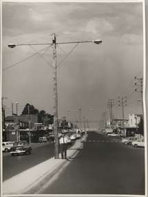
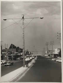
Research provided by Stuart Tompkins Studio, Box Hill, into alternatives for median strip street lighting to be used in Burke Road, Kew. The photographers identified variants in different suburbs appropriate to Kew's needs.The series from which the photograph is drawn provides a snapshot by a commercial photographic studio of each named vicinity in 1965 as well as providing examples of public works infrastructure being commissioned by local government in the 1960s. The photos originally formed part of the Engineering Department's files in the City of Kew before being donated to the kew Historical Society.Electricity Supply Poles, North Road, Ormond, 1965. Electricity supply poles photographed for the Kew City Council by Stuart Tompkins Studio. The photograph of North Road, Ormond west of Jasper Road, looking east depicts wooden poles carrying two lamps in a median strip and with two on each side alternately. It was noted that the supply wires were from one side only. The poles were described as 3′ above ground and 11.25″ in diameter. The plan was to use this approach for Burke Road, Kew. [There are three copies of this photograph in the Collection.] Typed inscription on reverse: "Electricity Supply Poles. Photographed for Kew City Council 8/2/65. No.1 North Road - Ormond, west of Jasper Road, looking east. Wooden poles carrying two lamps in median strip and two on each side alternately just as is proposed for Burke Road, Kew. Supply wires from one side only. Poles 3' above ground 11 1/4" dia." Studio stamp: "Stuart Tompkins Studio. 547 Station Street, Box Hill. WX1439."stuart tompkins studio, street lighting, south road (moorabin) 1965, public infrastructure -- city of kew, city of kew -- engineer's department -
 Kew Historical Society Inc
Photograph, Stuart Tompkins Studio, Electricity Supply Poles, North Road, Ormond, 1965
Research provided by Stuart Tompkins Studio, Box Hill, into alternatives for median strip street lighting to be used in Burke Road, Kew. The photographers identified variants in different suburbs appropriate to Kew's needs.The series from which the photograph is drawn provides a snapshot by a commercial photographic studio of each named vicinity in 1965 as well as providing examples of public works infrastructure being commissioned by local government in the 1960s. The photos originally formed part of the Engineering Department's files in the City of Kew before being donated to the kew Historical Society.Electricity Supply Poles, North Road, Ormond, 1965. Electricity supply poles photographed for the Kew City Council by Stuart Tompkins Studio. The photograph of North Road, Ormond west of Jasper Road, looking east depicts wooden poles carrying two lamps in a median strip and with two on each side alternately. It was noted that the supply wires were from one side only. The poles were described as 3′ above ground and 11.25″ in diameter. The plan was to use this approach for Burke Road, Kew. [There are three copies of this photograph in the Collection.] Typed inscription on reverse: "Electricity Supply Poles. Photographed for Kew City Council 8/2/65. No.1 North Road - Ormond, west of Jasper Road, looking east. Wooden poles carrying two lamps in median strip and two on each side alternately just as is proposed for Burke Road, Kew. Supply wires from one side only. Poles 3' above ground 11 1/4" dia." Studio stamp: "Stuart Tompkins Studio. 547 Station Street, Box Hill. WX1439."stuart tompkins studio, street lighting, south road (moorabin) 1965 -
 Kew Historical Society Inc
Photograph, Stuart Tompkins Studio, Electricity Supply Poles, North Road, Ormond, 1965
Research provided by Stuart Tompkins Studio, Box Hill, into alternatives for median strip street lighting to be used in Burke Road, Kew. The photographers identified variants in different suburbs appropriate to Kew's needs.The series from which the photograph is drawn provides a snapshot by a commercial photographic studio of each named vicinity in 1965 as well as providing examples of public works infrastructure being commissioned by local government in the 1960s. The photos originally formed part of the Engineering Department's files in the City of Kew before being donated to the kew Historical Society.Electricity Supply Poles, North Road, Ormond, 1965. Electricity supply poles photographed for the Kew City Council by Stuart Tompkins Studio. The photograph of North Road, Ormond west of Jasper Road, looking east depicts wooden poles carrying two lamps in a median strip and with two on each side alternately. It was noted that the supply wires were from one side only. The poles were described as 3′ above ground and 11.25″ in diameter. The plan was to use this approach for Burke Road, Kew. [There are three copies of this photograph in the Collection.] Typed inscription on reverse: "Electricity Supply Poles. Photographed for Kew City Council 8/2/65. No.1 North Road - Ormond, west of Jasper Road, looking east. Wooden poles carrying two lamps in median strip and two on each side alternately just as is proposed for Burke Road, Kew. Supply wires from one side only. Poles 3' above ground 11 1/4" dia." Studio stamp: "Stuart Tompkins Studio. 547 Station Street, Box Hill. WX1439."stuart tompkins studio, street lighting, south road (moorabin) 1965