Showing 987 items
matching old gold
-
 Eltham District Historical Society Inc
Photograph, Upper Yarra Dam, Spring Tour, 22 Oct 1995, 22/10/1995
EXPLORING THE UPPER YARRA (Newsletter No. 105, November 1995, by Bettina Woodburn) We enjoyed the Spring Excursion, this year "Exploring the Upper Yarra" - in spite of the constant rain and the countryside under the cloud cover, especially in the valleys, being mainly shiny shades of green. The occasional fields of buttercups, clumps of arum lilies and splendid rhododendron and other flowering bushes became very special. The Cobb and Co coach was warm and a cosy retreat as we zig-zagged on the highways and byways to glimpse the Yarra River, upstream and down, its secret places, and particularly the many bridges. Russell excelled as 'Poet Laureate', reading from Dacre Smyth's book. This 1979 publication includes paintings of all the bridges along the river with poems and brief descriptions of each one. Some of the bridges are in out of the way places and are not very well known. We looked forward to hearing the poetry as much as seeing the ' constructions'…Big Pat (was he short or tall, lean or fat? He did win the two hundred pound reward for discovering gold and had the creek named after him), about the 'Eddies'?, and the disliked 'meccano' bridge in Warburton, etc. etc. The hot roast lunch in the old Reefton Hotel was also most welcome. It was easy to imagine it peopled by miners and early settlers. Starting by crossing the new (1974) concrete bridge at Warrandyte we headed through Wonga Park with views to the Christmas Hills and to the escarpment of the Yering Gorge, which causes flood waters to back up through the Yarra Glen plain, so avoiding disasters downstream. At the end of a long driveway we found the wooden, privately owned Henley Bridge (1935 after the 1934 floods). This facilitates access to different parts of Henley Farm and to Lilydale. Everard Park, named after Blanche Shallard's father, a State Member for 17 years, below the Highway Yarra crossing was in need of care. It is 10 miles from Yarra Glen by road but, as "Yarra Marra” canoeists well know, 32 winding miles down by water. After more delightful countryside scenes we joined the Warburton Highway at Woori Yallock. From the old Railway Station at Launching Place the Centennial Trail for walkers, cyclists and ' horse riders has replaced the rails. The line from Lilydale was opened in 1901, and the last diesel freight train ran to Warburton in 1965. It continued to rain as we had morning tea in Warburton in a shelter between footbridges. From here we continued upstream past the Bridge to O'Shannasy Lodge and Reservoir, Starvation Creek, and the Peninsular tunnel (miners dug it as at Pound Bend) which we visited (scrambling down those steps!) on our return after lunch. Our furthermost point was the Upper Yarra Dam Reserve (and vast catchment area). Finished in 1957 after ten years work and 100 years after Yan Yean, it supplies much of Melbourne's water. After crossing the 30m Launching Place Bridge to the Eltham side of the Yarra and Healesville, we saw in the distance the Yarra Glen Timber Trestle Bridge over the river flats "the longest for years in the land it was said!" Harry's dream of "better weather over the Divide" unfortunately didn't come true, but I'm sure we 36 members will retain happy memories of a day that was wet and green and filled with Bridges. Bettina Woodburn - October 1995 Record of the Society's history of activities - Spring 1995 excursionRoll of 35mm colour negative film, 3 stripsKodak Gold 200-4shire of eltham historical society, activities, upper yarra dam, henley bridge -
 Eltham District Historical Society Inc
Photograph, Upper Yarra Dam, Spring Tour, 22 Oct 1995, 22/10/1995
EXPLORING THE UPPER YARRA (Newsletter No. 105, November 1995, by Bettina Woodburn) We enjoyed the Spring Excursion, this year "Exploring the Upper Yarra" - in spite of the constant rain and the countryside under the cloud cover, especially in the valleys, being mainly shiny shades of green. The occasional fields of buttercups, clumps of arum lilies and splendid rhododendron and other flowering bushes became very special. The Cobb and Co coach was warm and a cosy retreat as we zig-zagged on the highways and byways to glimpse the Yarra River, upstream and down, its secret places, and particularly the many bridges. Russell excelled as 'Poet Laureate', reading from Dacre Smyth's book. This 1979 publication includes paintings of all the bridges along the river with poems and brief descriptions of each one. Some of the bridges are in out of the way places and are not very well known. We looked forward to hearing the poetry as much as seeing the ' constructions'…Big Pat (was he short or tall, lean or fat? He did win the two hundred pound reward for discovering gold and had the creek named after him), about the 'Eddies'?, and the disliked 'meccano' bridge in Warburton, etc. etc. The hot roast lunch in the old Reefton Hotel was also most welcome. It was easy to imagine it peopled by miners and early settlers. Starting by crossing the new (1974) concrete bridge at Warrandyte we headed through Wonga Park with views to the Christmas Hills and to the escarpment of the Yering Gorge, which causes flood waters to back up through the Yarra Glen plain, so avoiding disasters downstream. At the end of a long driveway we found the wooden, privately owned Henley Bridge (1935 after the 1934 floods). This facilitates access to different parts of Henley Farm and to Lilydale. Everard Park, named after Blanche Shallard's father, a State Member for 17 years, below the Highway Yarra crossing was in need of care. It is 10 miles from Yarra Glen by road but, as "Yarra Marra” canoeists well know, 32 winding miles down by water. After more delightful countryside scenes we joined the Warburton Highway at Woori Yallock. From the old Railway Station at Launching Place the Centennial Trail for walkers, cyclists and ' horse riders has replaced the rails. The line from Lilydale was opened in 1901, and the last diesel freight train ran to Warburton in 1965. It continued to rain as we had morning tea in Warburton in a shelter between footbridges. From here we continued upstream past the Bridge to O'Shannasy Lodge and Reservoir, Starvation Creek, and the Peninsular tunnel (miners dug it as at Pound Bend) which we visited (scrambling down those steps!) on our return after lunch. Our furthermost point was the Upper Yarra Dam Reserve (and vast catchment area). Finished in 1957 after ten years work and 100 years after Yan Yean, it supplies much of Melbourne's water. After crossing the 30m Launching Place Bridge to the Eltham side of the Yarra and Healesville, we saw in the distance the Yarra Glen Timber Trestle Bridge over the river flats "the longest for years in the land it was said!" Harry's dream of "better weather over the Divide" unfortunately didn't come true, but I'm sure we 36 members will retain happy memories of a day that was wet and green and filled with Bridges. Bettina Woodburn - October 1995 Record of the Society's history of activities - Spring 1995 excursionRoll of 35mm colour negative film, 2 stripsKodak Gold 100-4shire of eltham historical society, activities, upper yarra dam, henley bridge -
 Eltham District Historical Society Inc
Photograph, Upper Yarra Dam, Spring Tour, 22 Oct 1995, 22/10/1995
EXPLORING THE UPPER YARRA (Newsletter No. 105, November 1995, by Bettina Woodburn) We enjoyed the Spring Excursion, this year "Exploring the Upper Yarra" - in spite of the constant rain and the countryside under the cloud cover, especially in the valleys, being mainly shiny shades of green. The occasional fields of buttercups, clumps of arum lilies and splendid rhododendron and other flowering bushes became very special. The Cobb and Co coach was warm and a cosy retreat as we zig-zagged on the highways and byways to glimpse the Yarra River, upstream and down, its secret places, and particularly the many bridges. Russell excelled as 'Poet Laureate', reading from Dacre Smyth's book. This 1979 publication includes paintings of all the bridges along the river with poems and brief descriptions of each one. Some of the bridges are in out of the way places and are not very well known. We looked forward to hearing the poetry as much as seeing the ' constructions'…Big Pat (was he short or tall, lean or fat? He did win the two hundred pound reward for discovering gold and had the creek named after him), about the 'Eddies'?, and the disliked 'meccano' bridge in Warburton, etc. etc. The hot roast lunch in the old Reefton Hotel was also most welcome. It was easy to imagine it peopled by miners and early settlers. Starting by crossing the new (1974) concrete bridge at Warrandyte we headed through Wonga Park with views to the Christmas Hills and to the escarpment of the Yering Gorge, which causes flood waters to back up through the Yarra Glen plain, so avoiding disasters downstream. At the end of a long driveway we found the wooden, privately owned Henley Bridge (1935 after the 1934 floods). This facilitates access to different parts of Henley Farm and to Lilydale. Everard Park, named after Blanche Shallard's father, a State Member for 17 years, below the Highway Yarra crossing was in need of care. It is 10 miles from Yarra Glen by road but, as "Yarra Marra” canoeists well know, 32 winding miles down by water. After more delightful countryside scenes we joined the Warburton Highway at Woori Yallock. From the old Railway Station at Launching Place the Centennial Trail for walkers, cyclists and ' horse riders has replaced the rails. The line from Lilydale was opened in 1901, and the last diesel freight train ran to Warburton in 1965. It continued to rain as we had morning tea in Warburton in a shelter between footbridges. From here we continued upstream past the Bridge to O'Shannasy Lodge and Reservoir, Starvation Creek, and the Peninsular tunnel (miners dug it as at Pound Bend) which we visited (scrambling down those steps!) on our return after lunch. Our furthermost point was the Upper Yarra Dam Reserve (and vast catchment area). Finished in 1957 after ten years work and 100 years after Yan Yean, it supplies much of Melbourne's water. After crossing the 30m Launching Place Bridge to the Eltham side of the Yarra and Healesville, we saw in the distance the Yarra Glen Timber Trestle Bridge over the river flats "the longest for years in the land it was said!" Harry's dream of "better weather over the Divide" unfortunately didn't come true, but I'm sure we 36 members will retain happy memories of a day that was wet and green and filled with Bridges. Bettina Woodburn - October 1995 Record of the Society's history of activities - Spring 1995 excursionRoll of 35mm colour negative film, 4 of 5 stripsKodak Gold 400-5shire of eltham historical society, activities, upper yarra dam, henley bridge -
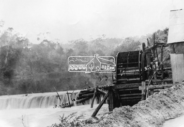 Eltham District Historical Society Inc
Photograph, Remains of the old Water Wheel and Battery, Warrandyte, 1934
A short distance upstream from the old wooden Warrandyte Bridge, the Yarra river was at one time dammed to give power to a large wooden waterwheel which drove a plant for crushing gold. Up until around 1908 the waters of the Yarra, pent up by a stone weir, forced their way past this old wheel turning it to crush the precious quartz. In 1925 the reamins of the State Battery were removed. The large water wheel (thanks to the forethought of a local resident, Mr. P. Mackie) was left in its position.This photo forms part of a collection of photographs gathered by the Shire of Eltham for their centenary project book,"Pioneers and Painters: 100 years of the Shire of Eltham" by Alan Marshall (1971). The collection of over 500 images is held in partnership between Eltham District Historical Society and Yarra Plenty Regional Library (Eltham Library) and is now formally known as the 'The Shire of Eltham Pioneers Photograph Collection.' It is significant in being the first community sourced collection representing the places and people of the Shire's first one hundred years.Digital image 4 x 5 inch B&W Negshire of eltham pioneers photograph collection, warrandyte, water wheel, caledonia battery, state battery, warrandyte battery -
 Eltham District Historical Society Inc
Negative - Photograph, Members of the Hill family, early Eltham settlers, c.1860
Mrs Georgina Hill (wife of Henry), nee Reynolds (of Research, Vic.) in cap [possibly misidentified by donor - see note below] with Mrs Isaac Hill and her children (left to right) Amelia Hill, (born 1853) Mrs Isaac Hill with baby Isaac (born 1860, Eltham) on her lap. Mary Jane Hill (born 1857, Eltham) seated on Mrs Henry Hill's lap and Bob Hill. The Hill family were early settlers of the Eltham area. Daguerreotype photo enclosed in a leather bound clam shell box with felt lining and gold trim. Donated by Mrs Ivy Edna Hill, 4/1 Bridge Street, Eltham, 4 June 1966 and includes copy of her note identifying the people. Daguerreotypes were one of the first forms of early photographs. They initially appeared in Europe in 1839 and were produced in large numbers to the early 1850s but were superseded by more modern and flexible forms of technology by 1860. The photo was usually formed on a thin copper plate with light sensitve silver iodide. They have a mirror-like appearance and the image itself was mirrored. They were usually inserted into a case or frame made of wood bound in leather or velvet and cost about one guinea in Australia, the equivalent of a week's wages. With the advent of the gold-rush and growing population came an increase in numbers of photographers both studio and travelling. The daguerreotype process was protected by patents and could only result in a single image from which no copies could be made. With new technology involving wet colloidion glass plate negatives and albumen paper prints of which multiple copies could be produced at significantly reduced cost, the dauguerreotype quickly fell out of favour. An accompanying note with the photo written by Edna Hill of 4/1 Bridge Street Eltham dated 4 June 1966 states: "Dear Mr Watson, I think the enclosed old time photograph will be of interest to you. It would have been taken about 1860. The two ladies are the wives of the original pioneers of the Hill family. The one in the cap was the wife of Henry Hill, the other of Isaac Hill. The children are those of Mrs Isaac Hill, and grandchildren to Henry Hill. The little girl on the left is Amelia, the baby Isaac, the second girl is Mary Jane, and the boy on the right is Bob Hill. They grew up tobe Uncles and Aunts of my late husband. I greatly appreciated a letter received a few months ago per Cr Pelling, from the Shillinglaw Cottage Committee. Yours sincerely, Edna Hill" Victorian birth registrations show Mary Jane Hill was born 1857 in Eltham (9879 / 1857) and Isaac Hill at Eltham in 1860 (1972/1860) NOTE: Mrs Isaac Hill was Ellen Fitzsimons (1834-1863), mother to Henry Hill. Mrs Georgina Hill, wife of Henry cannot be the lady in the cap as she was not born till 1864. Georgina Reynolds (1864-1927) married Henry Hill (1862-1948) in 1884. This lady has significant wrinkling of the face, especially around her mouth. It is possible that she is the mother of Mrs Isaac Hill (Ellen Fitzsimons) who was Isabella Fitzsimons (nee Ferguson).This photo forms part of a collection of photographs gathered by the Shire of Eltham for their centenary project book,"Pioneers and Painters: 100 years of the Shire of Eltham" by Alan Marshall (1971). The collection of over 500 images is held in partnership between Eltham District Historical Society and Yarra Plenty Regional Library (Eltham Library) and is now formally known as 'The Shire of Eltham Pioneers Photograph Collection.' It is significant in being the first community sourced collection representing the places and people of the Shire's first one hundred years.Digital image 4 x 5 inch B&W Negsepp, shire of eltham pioneers photograph collection, eltham, hill family, research (vic.), women, amelia hill, bob hill, daguerreotype, early settlers, georgina hill (nee reynolds), isaac hill, mary jane hill, mrs henry hill, mrs isaac hill, ellen hill (nee fitzsimons), isabella fitzsimons (nee ferguson) -
 Kiewa Valley Historical Society
Bowl Covered, circa mid to late 1900's
This covered glass bowl with lid was made in a period when there was a strict discipline in the use a various dishes and accompaniments with respect to the type of crockery used. This was in the English style, especially in well to do rural family estates. This period was part of the early 1900's, when large rural acreage was family owned and the economical return to rural produce was very high. It was a time when the Australian economy "rode on the back of sheep"This item has relative significance to the Kiewa Valley as part of the rural and mining(gold) era when the strong return from local gold mining and grazing was demonstrated by the "landed gentry" and significant household cutlery, crockery, etiquette and old English mores, influenced by "Mother Britain"This green opalescent covered bowl is similar to the French PV cabbage form. When the lid is on the bowl appears as a small cabage with three sets of half peeled leaves. There are five outer leaves, next row are five inner leaves and finally three core leaves. The main bowl has a lip encircling the inside of the bowl for the lid to rest upon with closed. The glass has been pressed to show the leaves with their web like stalks. The inside area of the bowl and lid are smooth. This is to allow the mashed up contents to be easily scraped into a serving ladle.Barely visible "VALLERYSTHAL"glass bowls, kitchen crockery, serving etiquette, meal presentation -
 Eltham District Historical Society Inc
Photograph, Clearing land for Le Pine Funeral Home, cnr York Street and Main Road, Eltham, c.March 1998, 1998
Newsletter No. 116, September, 1997 846-848 MAIN ROAD ELTHAM Nillumbik Shire Council has granted a permit for a funeral parlour on land which includes this site at the corner of Main Road and York Street. The site contains an architect's office in a building which was formerly a shop and dwelling dating from the 1920's. The proposal requires demolition of this building which is one of the few remaining old shops which formed the rather spread out "town centre" of Eltham. Prior to making its decision the Council obtained a report from Graeme Butler and Associates, the heritage consultants who carried out Stage 1 of the Nillumbik Heritage Study. The report summarized the historical significance as follows:- "This brick comer shop with associated residence has potential local historical significance as a late 1920's grocer's shop, now much altered and one of only a few shops of that era left in Eltham's Main Road. This significance is qualified by the many changes. The other examples are better preserved and still function as shops." With this type of expert advice it is difficult to make a strong case for preservation of the building although, of course, it is a shame to see it demolished. The report includes details of the site itself and its history based on research carried out by Carlotta Kellaway. The building dates from the late 1920's when it was owned by C.R. Nicholls. From the early 1930's it was Charles Cockroft's grocery shop and he also ran a grain store there. According to his daughter, Edna Brown, he delivered groceries around the district taking his truck as far as Kangaroo Ground. In 1950 he shifted to Traralgon. Since then several different businesses have operated from the site including a bottle merchant and produce store. Conversion to the present office use involved alterations to the shop front and rebuilding the galvanized iron store at the rear. Newsletter 119 March 1998 In our Newsletter No. 116 it was reported that the former shop on the comer of Main Road and York Street, Eltham was to be demolished as part of a funeral parlour development. If you have passed the site recently you will have noticed that it has now been demolished - another part of the old Eltham township has disappeared.Roll of 35mm colour negative film, 6 strips Also photographic prints 10 x 15 cmKodak Gold 200-6a.r. warren, eltham feed store, le pine funeral home, main road, york street, c.r. nicholls, charles cockcroft, grocery store -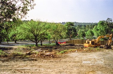
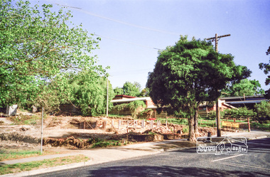 Eltham District Historical Society Inc
Photograph, Clearing land for Le Pine Funeral Home, cnr York Street and Main Road, Eltham, c.March 1998, 1998
Newsletter No. 116, September, 1997 846-848 MAIN ROAD ELTHAM Nillumbik Shire Council has granted a permit for a funeral parlour on land which includes this site at the corner of Main Road and York Street. The site contains an architect's office in a building which was formerly a shop and dwelling dating from the 1920's. The proposal requires demolition of this building which is one of the few remaining old shops which formed the rather spread out "town centre" of Eltham. Prior to making its decision the Council obtained a report from Graeme Butler and Associates, the heritage consultants who carried out Stage 1 of the Nillumbik Heritage Study. The report summarized the historical significance as follows:- "This brick comer shop with associated residence has potential local historical significance as a late 1920's grocer's shop, now much altered and one of only a few shops of that era left in Eltham's Main Road. This significance is qualified by the many changes. The other examples are better preserved and still function as shops." With this type of expert advice it is difficult to make a strong case for preservation of the building although, of course, it is a shame to see it demolished. The report includes details of the site itself and its history based on research carried out by Carlotta Kellaway. The building dates from the late 1920's when it was owned by C.R. Nicholls. From the early 1930's it was Charles Cockroft's grocery shop and he also ran a grain store there. According to his daughter, Edna Brown, he delivered groceries around the district taking his truck as far as Kangaroo Ground. In 1950 he shifted to Traralgon. Since then several different businesses have operated from the site including a bottle merchant and produce store. Conversion to the present office use involved alterations to the shop front and rebuilding the galvanized iron store at the rear. Newsletter 119 March 1998 In our Newsletter No. 116 it was reported that the former shop on the comer of Main Road and York Street, Eltham was to be demolished as part of a funeral parlour development. If you have passed the site recently you will have noticed that it has now been demolished - another part of the old Eltham township has disappeared.Roll of 35mm colour negative film, 6 strips Also photographic prints 10 x 15 cmKodak Gold 200-6a.r. warren, eltham feed store, le pine funeral home, main road, york street, c.r. nicholls, charles cockcroft, grocery store