Showing 30481 items matching "old-collegians-association"
-
 Ballarat Tramway Museum
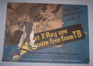
Poster, Victorian Tuberculous Association, 1970/1980
Poster advertising Victorian Tuberculous Association and the need to get chest X-rays for the prevention of TB. Has the address and telephone numbers on the poster. May have been used in a Ballarat. Appears to have been adhered to an earlier advertisement.trams, tramways, advertisements, posters -
 Greensborough Historical Society
Newsletter, Greenhills and North Greensborough Progress Association, Community News: official journal of the Greenhills and Nth.Greensborough Progress Association and the Apollo Parkways Progress Association. 1st April, 1976. Edition No. 3/76, 01/04/1976
This edition includes a report on the The Apollo Parkways Progress Association's March 1976 meeting, Sporting complex for Diamond Valley, History in the district, 300 miles of park... the forestry concept, This and that, Functions of your local Health Department, School and Kinder news, Guide news, Battle of the bluestone, From the Council Chamber, Meet the natives, Diamond Valley Repertory, Apex Club in Greensborough. A digital copy of this Newsletter is available from Greensborough Historical Society. Newsletter, 28 p., illus.greenhills and north greensborough progress association, greenhills, apollo parkways progress association, apollo parkways -
 Greensborough Historical Society
Newsletter, Greenhills and North Greensborough Progress Association, Community News: official journal of the Greenhills and Nth. Greensborough Progress Association and the Apollo Parkways Progress Association. 5th July 1976. Edition No. 6/76, 05/07/1976
This edition includes a report on the The Apollo Parkways Progress Association's June1976 meeting, Great Greenhills happening, A foreigner in Melbourne, Lonely people, Feeling -- Belonging -- Sharing, Nerve deafness, Family Day Care, From the Council Chamber, Cameo of Graeme Davies, Lost in Lerderderg Gorge, This and that, Meet the natives, Plenty Valley Squash Club, School and Kinder news, Scout and Guide news. A digital copy of this Newsletter is available from Greensborough Historical Society.Newsletter, 27 p., illus.greenhills and north greensborough progress association, greenhills, apollo parkways progress association, apollo parkways -
 Old Colonists' Association of Ballarat Inc.
Photograph - Photograph - Colour, Gerald Jenzon Pours a Beear at the Old Colonists' Hall, 2008, 08/04/2008
A member of the Old Colonists' Association of Ballarat, he has been president of both the Old Colonists' Association and the Old Colonists' Club.Colour photograph of the Gerald Jemzem pouring a beer at the Old Colonists' Hall.ballarat old colonists' club, old colonists' hall, gerald m. jenzen -
 Ringwood and District Historical Society
Newsletters, Australasian Association for Theatre Technology (Vic.) Ltd, Australasian Association for Theatre Technology (Vic.): Newsletters. 1979, 1979
With the Clocktower Theatre Company papers - possibly used by them.3 newsletters of Australasian Association for Theatre Technology (Vic.) Ltd, 1 green, 1 pink, 1 blue, dated April, May and June 1979. 3 bifold A4 pages, stapled. +Additional Keywords: Everitt, R.T. (Editor) -
 Ballarat Tramway Museum
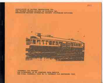
Programme, Association of Railway Enthusiasts (ARE), "Farewell Old Friend", Aug. 1989
Five page duplicated document contained within orange colour card covers with one of the 3 copies side bound with plastic binding. Titled "Farewell Old Friend", "The withdrawal of W2 tramcars from Service, The final Farewell, Tour No. 3, Sat. 3 September 1988". Provides a welcome aboard, a safety message, organiser details, notes on the W2, a plan showing the route, route information and photo stops and on the rear cover, the route for tour 3 and previous tours. Tour organised by the Association of Railway Enthusiasts, Tramway Museum Society of Victoria and the Australian Railway Historical Society Vic Div.on Front cover of bound copy "ARE"trams, tramways, are, arhs, tmsv, w2 class, tours -
 Greensborough Historical Society
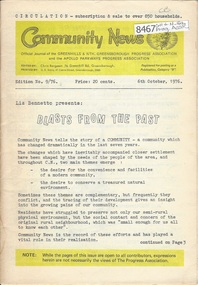
Newsletter, Greenhills and North Greensborough Progress Association, Community News: official journal of the Greenhills and Nth. Greensborough Progress Association and the Apollo Parkways Progress Association. 6th October, 1976. Edition No. 9/76, 06/10//1976
This editions includes report of the annual general meeting of the Apollo Parkways Progress Association held at September 1976 meeting, Blasts from the past, Great Greenhills spring happening, Parent Australia, Cameo of Geoff Kerry, Our fountain, Apollo Parkways fountain, You need not "go it" alone, In appreciation of teachers, This and that, From the Council Chamber, Community Health Services, be more health conscious!, School news, Scout news, Letters to the Editor. A digital copy of this Newsletter is available from Greensborough Historical Society. Newsletter, 28 p., illus.greenhills and north greensborough progress association, greenhills, apollo parkways progress association -
 Greensborough Historical Society
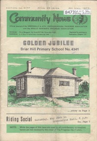
Newsletter, Greenhills and North Greensborough Progress Association, Community News: official journal of the Greenhills and Nth. Greensborough Progress Association and the Apollo Parkways Progress Association 4th May, 1977. Edition No. 4/77, 04/05/1977
This edition includes a report on the The Apollo Parkways Progress Association's March 1977 meeting, A word from our guest Editor, Briar Hill Primary School golden jubilee, From the Council Chamber, Promises! Promises! Promises!, Kinder news, Cameo of the Mckenzies, I remember when, I'm thinking aloud, Uranium: a moral issues not a political issue, Do you know about the... Montmorency Field Naturalists Club?, Scout news, This and that, Why oppose uranium mining? A digital copy of this Newsletter is available from Greensborough Historical Society. Newsletter, 24 p., illus.greenhills and north greensborough progress association, greenhills, apollo parkways progress association, apollo parkways -
 Waverley RSL Sub Branch
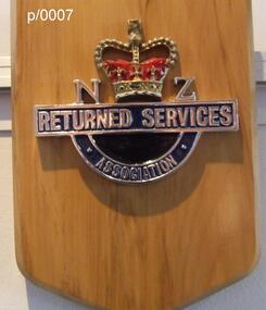
Plaque N Z Returned Services Association, N Z Returned Services Association
Wooden Plaque N Z Returned Services Association N Z Returned Services Association -
 Old Colonists' Association of Ballarat Inc.
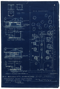
Plan - Architectural Blueprint, Old Colonists' Association Proposed New Cottages, Perry Park
The Old Colonists' Retirement village was build at Charles Anderson Grove.old colonists' association ballarat, charles anderson grove, retirement village, old colonists' association ballarat cottages -
Ballarat and District Irish Association
Photograph - digital, Clare Gervasoni, Ballaarat Old Cemetery Headstone for Catherine Hanley, 01/12/2013
Photograph of a broken Ballaarat Old Cemetery marble Headstone for Catherine Hanley, native of Tipperary, Ireland. She died on 16 July 1870. Also her sister, Margaret Robertson who died on 04 April 1886 aged 45, and their mother Margaret Hanley who died on 06 May 1889 aged 70 years. ballarat irish, ballaarat old cemetery, headstone, hanley, catherine hanley, margaret hanley, margaret robertson, robertson -
 Warrnambool and District Historical Society Inc.
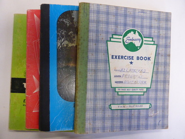
Booklet, Allansford Progress Association, Second half of 20th century
These four exercise books give documentation on the activities of the Allansford Progress Association (1966 to 1988). Allansford is a settlement about 9 kilometres from Warrnambool and most of the town area is now within the boundaries of the Warrnambool City Council. The association was re-formed in November 1966 after the demise of an earlier group. The members of the group campaigned in areas of local concern – T. V. reception, drainage and sewerage, postal services, sports facilities including the development of the Speedway, housing development, road proposals, waste management and disaster plans. These books are of interest in that they provide an overview of the history of a local organization. They will be useful for research. These are four exercise books - three Minutes books, and one Accounts book, from the Allansford Progress Association (1966-1988). The exercise books have coloured covers, (blue and white checkered, green, red and blue). Two are bound with tape and two are stapled. There are some loose sheets in all of the books. All the entries are handwritten. On front covers: ‘Allansford Progress Association’allansford progress association, history of allansford, history of warrnambool -
 Greensborough Historical Society
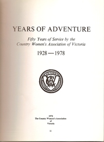
Book, Country Women's Association of Victoria, Years of adventure: fifty years of service by the Country Women's Association of Victoria, 1928-1978, 1928-1978
A short history of the Country Women's Association of Victoria 1928-1978. 76 pages, black and white photographs. Soft cover.country womens association of victoria -
 Melbourne Tram Museum
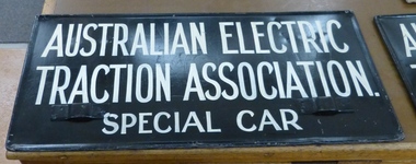
Sign, Australian Electric Traction Association (AETA), "Australian Electric Traction Association Special Car", 1950's
Sign, painted onto a MMTB auxiliary destination board of the type that could hang on the front of a Melbourne tram car with the words "Australian Electric Traction Association Special Car". Used for special tours by the AETA. Metal sign, fitted with metal hanging brackets, riveted to sign on both sides. Manufactured by rolling the outer edges over a 4mm diameter steel rod. Has been painted over a an old sign "Direct to Trotting Showgrounds??? via Abbotsford St 3d". Second sign painted over a sign that had on one side "Via Elsternwick" and "Via Balaclava Road". The signs were received wrapped in part of the "The Age, Thursday March 23 1961" - sample retained - see image 4. Image 5 shows the sign in use on L 104.trams, tramways, aeta, signs, auxiliary board -
 Greensborough Historical Society
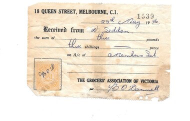
Financial record - Receipt, Grocer's Association of Victoria 1956, 28/05/1956
Member's subscription receipt for D. Seddon to The Grocer's Association of Victoria in 1956. Paper receipt, with stamp duty stamp affixed.Handwritten details, stamped receipt number 1539grocer's association of victoria, seddon family, grocers -
Ringwood and District Historical Society
Minute books, East Ringwood Progress Association Minute Books and papers 1948 - 1963, 1948-1963
Minutes of the East Ringwood Progress association over a period of 15 yearsBoxed set of four Minute books 1960-63: foolscap book with grey -blue hard cover.; 1955-1960 foolscap book with green hard cover and orange spine.; 1951-55 Brown envelope with loose minutes.; 1948-51 Pencraft exercise book Quarto sized pages with blue-grey patterned cover. -
 Ballarat Heritage Services
Photograph - Colour, Earth Banks, Old Sarum, England, 2016, 01 November 2016
William the Conqueror inherited Old Sarum from the last Saxon king of England. It was an ideal site for a royal castle. It was here in 1070 that William paid off his army after a long and bitter campaign in northern England. It was here in 1086 that he called together all the major landholders in England so they could swear allegiance to him. It was a crucial moment. The Domesday Book was being written, a threatened Viking invasion had only just been averted and William's eldest son was in armed rebellion. Old Sarum was an important place where this Norman king of England held power. In 1794 the Ordnance Survey set out to check the accuracy of the first mapping of Southern England, which had begun ten years earlier. From a point just below Old Sarum Lieutenant William Mudge laid out a base-line 36,574 feet (11,253 metres) long. From each end of the line the positions of distant places were plotted using a huge theodolite made in 1791 by Jesse Ramsden. The accuracy of the process, which was repeated all over England, depended on Jesse Ramsden's craftsmanship and on William Mudge's surveying skill in setting out this first base-line from Old Sarum. The nearer end of Mudge's line is marked by an inscribed stone beside the modern A345 at Old Sarum. ordnance survey, william mudge, jesse ramsden, william the conqueror, old sarum, saxon, 1086, england -
 Ballarat Heritage Services
Photograph - Colour, Earth Banks, Old Sarum, England, 01 November 2016
William the Conqueror inherited Old Sarum from the last Saxon king of England. It was an ideal site for a royal castle. It was here in 1070 that William paid off his army after a long and bitter campaign in northern England. It was here in 1086 that he called together all the major landholders in England so they could swear allegiance to him. It was a crucial moment. The Domesday Book was being written, a threatened Viking invasion had only just been averted and William's eldest son was in armed rebellion. Old Sarum was an important place where this Norman king of England held power. In 1794 the Ordnance Survey set out to check the accuracy of the first mapping of Southern England, which had begun ten years earlier. From a point just below Old Sarum Lieutenant William Mudge laid out a base-line 36,574 feet (11,253 metres) long. From each end of the line the positions of distant places were plotted using a huge theodolite made in 1791 by Jesse Ramsden. The accuracy of the process, which was repeated all over England, depended on Jesse Ramsden's craftsmanship and on William Mudge's surveying skill in setting out this first base-line from Old Sarum. The nearer end of Mudge's line is marked by an inscribed stone beside the modern A345 at Old Sarum. ordnance survey, william mudge, jesse ramsden, william the conqueror, old sarum, saxon, 1086, england -
 Ballarat Heritage Services
Photograph - Colour, Stonework, Old Sarum, England, English Heritage Site, 01 November 2016
William the Conqueror inherited Old Sarum from the last Saxon king of England. It was an ideal site for a royal castle. It was here in 1070 that William paid off his army after a long and bitter campaign in northern England. It was here in 1086 that he called together all the major landholders in England so they could swear allegiance to him. It was a crucial moment. The Domesday Book was being written, a threatened Viking invasion had only just been averted and William's eldest son was in armed rebellion. Old Sarum was an important place where this Norman king of England held power. In 1794 the Ordnance Survey set out to check the accuracy of the first mapping of Southern England, which had begun ten years earlier. From a point just below Old Sarum Lieutenant William Mudge laid out a base-line 36,574 feet (11,253 metres) long. From each end of the line the positions of distant places were plotted using a huge theodolite made in 1791 by Jesse Ramsden. The accuracy of the process, which was repeated all over England, depended on Jesse Ramsden's craftsmanship and on William Mudge's surveying skill in setting out this first base-line from Old Sarum. The nearer end of Mudge's line is marked by an inscribed stone beside the modern A345 at Old Sarum. ordnance survey, william mudge, jesse ramsden, william the conqueror, old sarum, saxon, 1086, england -
 Ballarat Heritage Services
Photograph - Colour, Stonework, Old Sarum, England, English Heritage Site, 2016, 01 November 2016
William the Conqueror inherited Old Sarum from the last Saxon king of England. It was an ideal site for a royal castle. It was here in 1070 that William paid off his army after a long and bitter campaign in northern England. It was here in 1086 that he called together all the major landholders in England so they could swear allegiance to him. It was a crucial moment. The Domesday Book was being written, a threatened Viking invasion had only just been averted and William's eldest son was in armed rebellion. Old Sarum was an important place where this Norman king of England held power. In 1794 the Ordnance Survey set out to check the accuracy of the first mapping of Southern England, which had begun ten years earlier. From a point just below Old Sarum Lieutenant William Mudge laid out a base-line 36,574 feet (11,253 metres) long. From each end of the line the positions of distant places were plotted using a huge theodolite made in 1791 by Jesse Ramsden. The accuracy of the process, which was repeated all over England, depended on Jesse Ramsden's craftsmanship and on William Mudge's surveying skill in setting out this first base-line from Old Sarum. The nearer end of Mudge's line is marked by an inscribed stone beside the modern A345 at Old Sarum. ordnance survey, william mudge, jesse ramsden, william the conqueror, old sarum, saxon, 1086, england -
 Ballarat Heritage Services
Photograph - Colour, Stonework and well, Old Sarum, England, English Heritage Site, 2016, 01 November 2016
William the Conqueror inherited Old Sarum from the last Saxon king of England. It was an ideal site for a royal castle. It was here in 1070 that William paid off his army after a long and bitter campaign in northern England. It was here in 1086 that he called together all the major landholders in England so they could swear allegiance to him. It was a crucial moment. The Domesday Book was being written, a threatened Viking invasion had only just been averted and William's eldest son was in armed rebellion. Old Sarum was an important place where this Norman king of England held power. In 1794 the Ordnance Survey set out to check the accuracy of the first mapping of Southern England, which had begun ten years earlier. From a point just below Old Sarum Lieutenant William Mudge laid out a base-line 36,574 feet (11,253 metres) long. From each end of the line the positions of distant places were plotted using a huge theodolite made in 1791 by Jesse Ramsden. The accuracy of the process, which was repeated all over England, depended on Jesse Ramsden's craftsmanship and on William Mudge's surveying skill in setting out this first base-line from Old Sarum. The nearer end of Mudge's line is marked by an inscribed stone beside the modern A345 at Old Sarum. ordnance survey, william mudge, jesse ramsden, william the conqueror, old sarum, saxon, 1086, england -
 Ballarat Heritage Services
Photograph - Colour, Stonework, Old Sarum, England, English Heritage Site, 01 November 2016
William the Conqueror inherited Old Sarum from the last Saxon king of England. It was an ideal site for a royal castle. It was here in 1070 that William paid off his army after a long and bitter campaign in northern England. It was here in 1086 that he called together all the major landholders in England so they could swear allegiance to him. It was a crucial moment. The Domesday Book was being written, a threatened Viking invasion had only just been averted and William's eldest son was in armed rebellion. Old Sarum was an important place where this Norman king of England held power. In 1794 the Ordnance Survey set out to check the accuracy of the first mapping of Southern England, which had begun ten years earlier. From a point just below Old Sarum Lieutenant William Mudge laid out a base-line 36,574 feet (11,253 metres) long. From each end of the line the positions of distant places were plotted using a huge theodolite made in 1791 by Jesse Ramsden. The accuracy of the process, which was repeated all over England, depended on Jesse Ramsden's craftsmanship and on William Mudge's surveying skill in setting out this first base-line from Old Sarum. The nearer end of Mudge's line is marked by an inscribed stone beside the modern A345 at Old Sarum. ordnance survey, william mudge, jesse ramsden, william the conqueror, old sarum, saxon, 1086, england -
 Ballarat Heritage Services
Photograph - Colour, Old Sarum, England, 2017, 01 November 2016
William the Conqueror inherited Old Sarum from the last Saxon king of England. It was an ideal site for a royal castle. It was here in 1070 that William paid off his army after a long and bitter campaign in northern England. It was here in 1086 that he called together all the major landholders in England so they could swear allegiance to him. It was a crucial moment. The Domesday Book was being written, a threatened Viking invasion had only just been averted and William's eldest son was in armed rebellion. Old Sarum was an important place where this Norman king of England held power. In 1794 the Ordnance Survey set out to check the accuracy of the first mapping of Southern England, which had begun ten years earlier. From a point just below Old Sarum Lieutenant William Mudge laid out a base-line 36,574 feet (11,253 metres) long. From each end of the line the positions of distant places were plotted using a huge theodolite made in 1791 by Jesse Ramsden. The accuracy of the process, which was repeated all over England, depended on Jesse Ramsden's craftsmanship and on William Mudge's surveying skill in setting out this first base-line from Old Sarum. The nearer end of Mudge's line is marked by an inscribed stone beside the modern A345 at Old Sarum. ordnance survey, william mudge, jesse ramsden, william the conqueror, old sarum, saxon, 1086, england