Showing 173566 items
matching pitt-street
-
 Lakes Entrance Historical Society
Book, Pitt M W and Synan T P, The Past Present and Future of the Gippsland Lakes, 1987
Edited account of the papers presented at the Save the Gippsland Lakes Committees symposium on Lake Wellington and Lake Coleman held in Sale, November 1986. Includes history, geology, flora and fauna, and the many aspects of human impact on the region. Ilwaterways, government -
 Eltham District Historical Society Inc
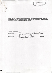
Document - Report, Dimity Reed et al, Advisory Commlttee Hearing on Permit Applications 96/0376, and 96/0377, and on Planning Appeals 96/40724 and 96/40812 re a proposed convenience centre at 895 Main Road, Eltham, June 1997
On 15 December 1994 the former Shire of Eltham ceased to exist following the Liberal Kennett Government local council amalgamations. A new Nillumbik Shire Council was established with unelected commissioners appointed. That Council sold the former Eltham Shire Council Offices and land at 89S Main Road Eltham to Dallas Price Homes Pty. Ltd. the sale being conditional upon the granting of a planning permit for a petrol station/convenience store, fast food and video outlet. The sale was conditional that if the permit was not granted by 30 August. 1997, the contract could be avoided by either the purchaser or the vendor. The proposed development consisted of a petrol station with undercover fuelling facilities, convenience shopping, a drive through service facility for fast food, an 80 seat cafe, automated banking, a children's play area and retail space. In addition, the proposal included a 200 square metre community facility for Council use, provision of on site carparking over 2 levels for 83 vehicles, and advertising signage. The Advisory Committee was appointed under Section 151 of the Planning and Environment Act 1987 to hear submissions on the proposal to develop the land at 895 Main Road Eltham, the site of the former Eltham Shire Offices. In September 1996, two applications were made by Contour Consultants Australia Pty Ltd on behalf of Dallas Price Homes Ply Ltd, to Nillumbik Shire Council. After extensive notification, the Council received 213 objections and a petition of over 1400 signatures. On October 9, 1996, Nillumbik Shire Council issued Notices of Decision to Grant Permit on Applications number 96/03376 and 96/0377 for the use and development of the land as a convenience Centre consisting of a petrol station, convenience store, cafe/takeaway food premises, a retail facility and a community facility, with associated advertising signs. Objectors to the proposals lodged Planning Appeals number 96/40724 and 96/40812 with the Administrative Appeals Tribunal on November 1, 1996. The grounds of appeal can be summarised as: inappropriate development, insufficient carparking, traffic and access issues, unsatisfactory design, inadequate permit conditions, the proposal being out of character with the area. and being contrary to the purpose and orderly development of the Eltham Town Centre, excessive noise, lack of consultation and unsuitable signage. On November 13, 1996, the Minister for Planning and Local Government directed the Registrar of the Administrative Appeals Tribunal. under Section 41 (1) (a) of the Planning Act 1980, to refer the Appeals to the Governor in Council for determination without a hearing or recommendation by the Tribunal. The Minister for Planning and Local Government called in the Appeals as he considered that they raised major issues of policy relating to the facilitation of development in accordance with the objectives set out in Section 4 of the Planning and Environment Act 1987, and that determination of the Appeals could have a substantial effect on the achievement of these planning objectives. The Minister required the Advisory Committee to consider the planning merits of the proposed use and development, and to address the issues raised in the objections. The Advisory Committee was required to produce a report providing: • The Committee's response to the matters detailed; • Relevant supporting information for the Advisory Committee's recommendation; and • A description of the proceedings conducted by the Advisory Committee and a list of those consulted or heard by the Committee. In March 1997, elections were held in the Shire of Nillumbik and the view of the new Council to this proposal differed from the view held by the earlier Council Hence the Submission made to the Committee by the Shire was against the decision by the Shire of Nillumbik to issue the Notices of Decision to Grant a Permit. The Recommendations of the Advisory Committee were: i. The cafe and take away food premises are as of right uses and are therefore allowable, but that shop and petrol station are unacceptable uses. A community facility is a discretionary use and is acceptable. ii. A development of the type and scale proposed is totally inappropriate for this land and that the Applications number 96/03376 and 96/0377 for the use and development of the land as a convenience Centre consisting of a petrol station, convenience store, café/takeaway food premises, a retail facility and a community facility, with associated advertising signs, be refused. iii. The land should be rezoned for public purposes and should remain in the community's ownership for community use. 895 main road, advisory committee, dallas price homes, eltham, eltham shire office, nillumbik shire council, planning application, administrative appeals tribunal -
 Whitehorse Historical Society Inc.
Clothing - Child's dress, Grandmother of Christine Pitt, C 1925's
- Made by donor's grandmother for donor's mother.- Printed cotton fabric - Detailed cuff & neckline (Plain fabric)Nilchild's clothing, handmade -
 Monbulk RSL Sub Branch
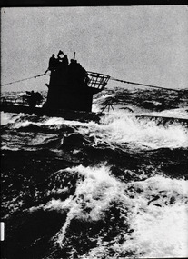
Book, Time-Life Books, The battle of the Atlantic, 1977
Germany attempts to strangle Britain--U-boats--Bismarck--convoys--Allied counterattack.Index, bib, ill, , maps, p.208.non-fictionGermany attempts to strangle Britain--U-boats--Bismarck--convoys--Allied counterattack. world war 1939-1945 - naval operations, world war 1939-1945 - campaigns - atlantic ocean -
 Ballarat Heritage Services
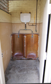
Photograph - Colour, Clare Gervasoni, Urinal at Barkly Street Uniting Church, 2015, 05/04/2015
This photograph was taken just before the Barkly Street Uniting Church was auctioned.Colour photograph of a urinal at Barkly Street Uniting Church.barkly street uniting church, ballarat, urinal, toilets -
 Bacchus Marsh & District Historical Society
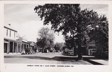
Postcard, Main Street, Bacchus Marsh, circa 1950
The Main Street of Bacchus Marsh underwent significant change from the early 1960s. Many older buildings began to be demolished after the early 1960s and into the 1980s. This view shows a central section of Main Street before this transformation took place. Produced as part of a series by the Murray Views Postcards and Souvenirs Company.Black and White postcard image of Main Street, Bacchus Marsh dated around 1950. View is looking towards the West.Murray Views No.7, Main Street, Bacchus Marsh, Vic.roads and streets bacchus marsh vic., main street bacchus marsh vic. -
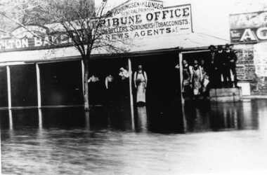 Charlton Golden Grains Museum Inc
Photograph, Flood High Street Charlton outside Tribune Office
Flood in High Street Charlton. People standing in front of Charlton Tribune Office.Flood High Street Charlton outside Tribune Officeflood, charlton tribune, charlton -
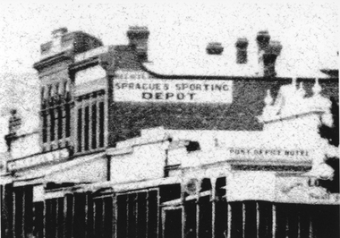 Stawell Historical Society Inc
Document, Sprague Sporting shop in Main Street Stawell with the Sprague Trophy
Sprague Sporting Depot building Main StreetB/W Photo of a street scape showing various buildings including Pots office Hotel & Sprague's Sporting Depot Copy from No.2 Street Scene Centering on Spragues shopSprague's Sporting Depot Post Office Hotelstawell, sprague sporting depot, street scene -
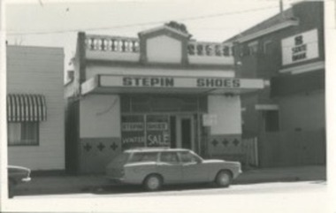 Kilmore Historical Society
Photograph, 25 Sydney Street, 1970's?
14cm x 9cm black and white photograph of the building on 25 Sydney Street. The occupants of the building is 'Stepin Shoes'. It is a light coloured building with decretive trims and written on the window is 'Winter Sale'. There is a station wagon vehicle parked out the front.Written on the back: 25 Sydney St Street Kilmore 25 Syd 011storefronts, shopfronts, retail stores -
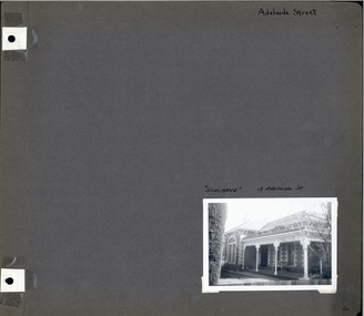 Glen Eira Historical Society
Album - Album page, Adelaide Street, Circa 1972
This photograph is part of the Caulfield Historical Album 1972. This album was created in approximately 1972 as part of a project by the Caulfield Historical Society to assist in identifying buildings worthy of preservation. The album is related to a Survey the Caulfield Historical Society developed in collaboration with the National Trust of Australia (Victoria) and Caulfield City Council to identify historic buildings within the City of Caulfield that warranted the protection of a National Trust Classification. Principal photographer thought to be Trevor Hart, member of Caulfield Historical Society. Most photographs were taken between 1966-1972 with a small number of photographs being older and from unknown sources. All photographs are black and white except where stated, with 386 photographs over 198 pages. Page 2 of Photograph Album including one black and white photograph of Woodbine, 18 Adelaide Street in bottom right hand corner. hand written "Adelaide Street [top right of page] / "Woodbine" 18 Woodbine St [above photograph] / 2 [bottom right]murrumbeena, woodbine, houses, trevor hart, polychrome brickwork, bi-chromatic brickwork, decorative brackets, cast iron pillars, verandah, porch, brick, adelaide street, victorian style, cast iron work -
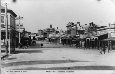 Stawell Historical Society Inc
Photograph, Main Street Stawell looking East towards the Post Office
This photograph is of Main Street Stawell looking East around c 1920's. The photo was taken from just below Main & Wimmera Street corner. On the left side is the two story Post Office building. The photograph shows the telegraph poles in the street. Also Copley Post Office Hotel 1912- 22 and other business. On the road are a few people one pushing a trolly, one on a bike and two people in a horse drawn cart. Gustav Mahnke's Bakery is on right.Two Black & White photographs depicting the main street in Stawell's commercial business area in c 1920's. The view shows some two story buildings, shops with verandah's. One horse drawn vehicle, a person on a bike and a few people in the street. There is also a paper print of the photograph donated by Robyn Mackenzie Bacchus Marsh in 2009 The Rose series, P 1639 Main Street, Stawell, Victoriastawell business shops streetscape -
 Ballarat Heritage Services
Photograph - Photograph - Colour, Dana Street Primary School From Doveton Street, Ballarat, c2007
Dana Street Primary School No 33 is one of Ballarat's earliest schools. A number of colour photographs of Dana Street Primary School, Ballarat. The photographs feature the original bluestone building, chimney, and other architectural features. The photos were taken at 7am.dana street primary school, dana street state school, bluestone -
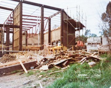
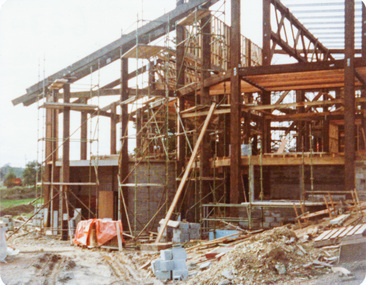
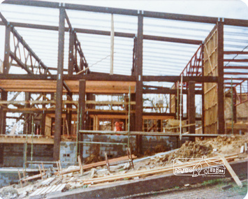
 Eltham District Historical Society Inc
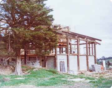
Photograph, Peter Bassett-Smith, Construction of Eltham Community Centre, June 1977, 1977
Three colour photographs: 1. Eltham Community Centre, Pitt Street, looking south 2. Eltham Community Centre, Pitt Street, looking south 3. Eltham Community Centre, Pitt Street, looking north; oregon uprights and mudbrick wallseltham, eltham community centre, buildings, construction -
 Eltham District Historical Society Inc
Photograph, Peter Bassett-Smith, Construction of Eltham Community Centre, June 1977, 1977
Three colour photographs: 1. Eltham Community Centre, Pitt Street, looking south 2. Eltham Community Centre, Pitt Street, looking south 3. Eltham Community Centre, Pitt Street, looking north; oregon uprights and mudbrick wallseltham, eltham community centre, buildings, construction -
 Ringwood and District Historical Society
Photograph, Street Scenes. Commercial premises in Ringwood Street, corner of Bond Street, Ringwood - 18/5/1981
Ringwood Street, corner of Bond StWritten on back of photograph, "18/5/81. Ringwood Street, corner of Bond St." -
Tatura Irrigation & Wartime Camps Museum
Photograph - original, Hogan Street Tatura 1932, 1932
Photograph showing Hogan street, Tatura in 1932. Showing telegraph poles, palm tree, big tree, fence and residence of Youngs cafe.Black and white original photograph of Hogan Street, Tatura, looking east. 1932.on back: Tatura, Hogan Street. looking east 1932. from corner - Youngs Cafe.hogan street tatura -
 Eltham District Historical Society Inc
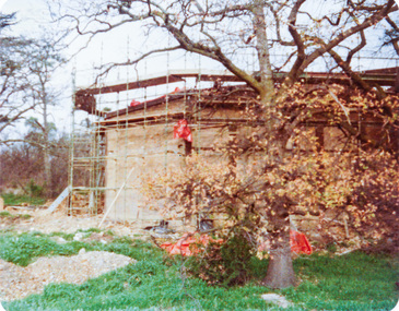
Photograph, Peter Bassett-Smith, Construction of Eltham Community Centre, June 1977, 1977
Two colour photographs: 1. Eltham Community Centre, Pitt Street, looking north 2. Eltham Community Centre, Pitt Street, looking northeltham, eltham community centre, buildings, construction -
 Eltham District Historical Society Inc
Photograph, Peter Bassett-Smith, Construction of Eltham Community Centre, June 1977, 1977
Two colour photographs: 1. Eltham Community Centre, Pitt Street, looking north 2. Eltham Community Centre, Pitt Street, looking northeltham, eltham community centre, buildings, construction -
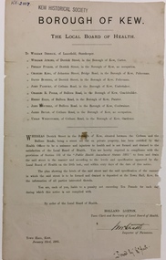 Kew Historical Society Inc
Document, Holland Loxton, Notification to the Residents of Derrick Street by the Local Board of Health, 1885, 1885
Streets and drains were the basic infrastructure problems for Kew in the 1880s. Decent streets and drains were fundamental to the quality of life of the residents. Without drainage, streets became muddy, boggy and sometimes impassable. Pools and puddles of stagnant water became smelly. The run off water, mixed with human and animal wastes, because there was no sewerage, became a health hazard. Streets and drains then became what were known as 'a nuisance'. Kew suffered from bouts of typhoid fever during the 1880s. Derrick Street was a private street on the margin of the business district of Kew and a well-used thoroughfare. We hear first about Derrick Street when the ratepayers applied to Council to have the street 'taken over' in January 1881. The Council agreed, after much debate, but ratepayers had to pay half the costs. The argument of the majority of the Council was that there was an established policy that ratepayers of private streets either had to hand over the street fully-formed or pay half the costs if Council did the work. It was felt that to make an exception for Derrick Street would create a precedent for ratepayers of other private streets. On the other hand the ratepayers, and a minority of Council, believed that there were extenuating circumstances in the case of Derrick Street. They believed that the costing by the Borough Surveyor was excessive. They felt the Council was partly responsible for the state of the street due to a channel on Bulleen Road, which deposited sand in the street. The Council had also put in some kerbing at the entrance to the street. Finally, the ratepayers believed that the street had become an important and convenient thoroughfare in Kew, and thus should be an exception to the policy on private streets. In the end a decision was delayed to allow the ratepayers to drain and form the street themselves. And there the matter stood till September 1882, when Miss Reilly complained about rubbish on a block of land in Derrick Street. So, in October 1882 the Council agreed to take over and form the street with the ratepayers paying half the costs. The ratepayers did not want to pay, so the argument continued in Council into 1883. There was a standoff for a further 18 months, until the problem could no longer be ignored. In October 1884 the Inspector of Nuisances and the Health Officer reported that Derrick Street was a health hazard as there was no drainage outlet for waste water. These reports changed the status of the problem of Derrick Street. It became an issue of public health, and thus the Council, acting as the Local Board of Health, had power to prepare plans and order the ratepayers to drain the street and pay all the costs, or let the Council do the work and charge ratepayers half the costs of the works. By April 1885, the time for ratepayers to complete the works themselves had expired, so the Council proceeded with the work and required ratepayers to pay for their share of the costs. All ratepayers had paid by the end of April except Mr Whiddycombe, who refused to pay. Mr Whiddycombe was warned to pay in October 1885. Legal action was taken against him in November. The Council lost the case on technical grounds. The Council, acting as the Local Board of Health, relaunched the legal action and won. The last we hear of Derrick Street is that seven day’s notice was given to Derrick Street ratepayers to pay for the drainage works in May 1887. We presume that Mr Whiddycombe paid. (Research: Andrew Frost)Rare and historic publication issued by the Board of Health in the Borough of Kew in 1885 to residents of Derrick street regarding the need for proper drainage for the purpose of improving public health.Printed formal notice sent by the Board of Health of the Borough of Kew to landowners in Derrick Street, Kew. The notice advised the owners that they were required to form and drain the street according to the levels and specifications approved by the Board. The letter was sent on January 23rd 1885, and signed by the Inspector of Nuisances.borough of kew -- greater melbourne (vic.), council notices -- public health, derrick street -- kew (vic.) -
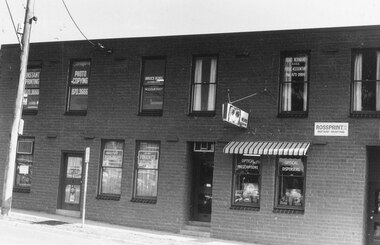
![EJ Harvey, Motor Engineers, High Street [Kew East], circa 1925](/media/collectors/550653872162f11fb04854aa/items/586f9929d0ce2607f0b81f1a/item-media/586f99e0d0ce2607f0b8546f/item-fit-380x285.jpg) Kew Historical Society Inc
Kew Historical Society IncPhotograph - Photograph [copy], EJ Harvey, Motor Engineers, High Street [Kew East], circa 1925, c. 1925
The building was in High Street, Kew East between Clyde and Oswin Streets. The site is currently (2017) occupied by a canoe retailer.Rare and historic photograph of an early business in the Harp Village shopping precinctGarage - E.J. Harvey, Motor Engineers workshop, High Street, East Kew. The garage was on the corner of Clyde Street.Inscription reverse: "High Street, East Kew - present site of Harvey Phillips Retro Vision[*] shop. Gift of Edna Phillips. Edna loaned KHS the original photo and KHS had it copied." * Note - Harvey Phillips Retravision not Retro Vision].motor engineers (kew), garages (kew), e.j. harvey -
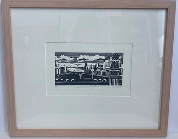 Glenelg Shire Council Cultural Collection
Artwork, other - Linocut, Bob Stone, Julia Street, 2007
Artwork features streets from Portland Victoria.Black and white linocut print. Image based on Julia Street Portland Victoria showing the Street and buildings looking toward the ocean. Foreground right an up close replicate of the sign pole of the middle of the roundabout between Percy and Julia Street, raised road crossings, road signs, Norfolk Island tree, ocean is visable with various Port structures. Sky is lined with clouds shaded black underneath.Along the bottom of the print written in grey lead 4/5 Julia Street, Portland Bob Stone 2007portand, julia street portland, linocut -
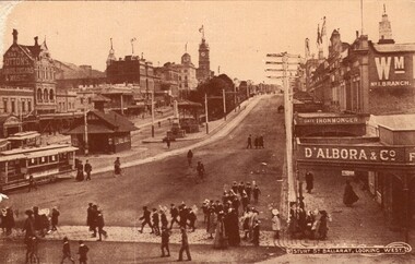 Ballarat Heritage Services
Photograph - Photograph - Black and White, Sturt Street, Ballarat, Looking West
P. D'Albora purchased the Sturt Street fruitshop in 1909. Ernest D'Albora ran a fruit shop in Sturt Street 1915.Black and white photograph of Sturt Street Ballarat from Bridge St looking towards the Ballarat Town Hall. ballarat, sturt street, d'albora and co, tram, suttons music store, ballarat town hall, galloway memorial, flagstones, bluestone, ernest d'albora, fruiterer, italo-australians -
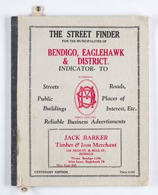 City of Greater Bendigo - Civic Collection
Book - Street Directory, McConnell Publisher, The Street Finder
General district street, business and services directory aimed less at the tourist market and more at the Bendigo and Eaglehawk population. Includes advertising. Index is extensive and includes services such as child care centres, cemeteries, theatres and schools.Thirty two page, printed and bound street and business directory for Bendigo, Eaglehawk and district. Grey card front cover with grey cardboard back cover. Printed in red and black ink. Includes Index for trades, streets and services such as banks, baths, sporting clubs and police stations. Majority of content is text and advertising and the only map included in the publication is printed inside the back cover.The Street Finder / for the municipalities of / Bendigo, Eaglehawk / & District. city of greater bendigo commerce, city of greater bendigo community groups, city of greater bendigo tourism, borough of eaglehawk, making a nation exhibition -
 Flagstaff Hill Maritime Museum and Village
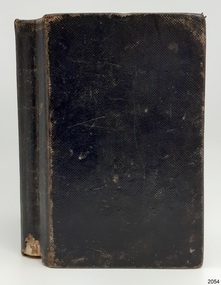
Book - Religious Book, Oxford University Press, The Holy Bible, 1859
Young Henry Pitts sailed from Liverpool, England, in about October 1860, on a ship called the 'British Trident'. About three months later, on January 7th 1861, he arrived in Sydney, Australia. While he travelled from one side of the world to the other, Henry attended lessons on the ship with his onboard teacher, Joseph Benton. On the day before the ship arrived at Sydney, Henry was given a Holy Bible by his teacher. The small black book had a hardcover and many printed pages of very thin paper. Henry must have felt special when he read his teacher’s beautifully written message that said the gift was a ‘mark of respect’ towards Henry. Maybe Mr Benton taught Henry to write with a pen and ink because Henry wrote his name several times inside the front of the book and again below his teacher’s message. Henry may have even learned to read from a Bible, which many passengers included in their luggage. The immigrants on board the British Trident were mostly new arrivals to Australia. Like Henry, they planned to make Australia their new home. Many also hoped to find work in this new country. Some passengers had family and friends waiting for them, people who deposited money towards their trip. Henry’s relative, Charles Pitts, had helped him pay for the ship’s passage, and William Oberthan paid money towards Joseph Benton’s fare. He may have planned for Joseph to work as a teacher in Australia. The Single Females were allowed to leave the ship the day after it docked at Sydney, but the Families and Single Men, including Henry and Joseph, had to stay onboard until Thursday. This Holy Bible is significant for its age, as it was published in 1859. The inscriptions within this small Bible are significant as they show that during a ship's voyage passengers had the opportunity to teach and to learn. They also show a relationship of encouragement had been built between the teacher and pupil. The Holy Bible containing the Old and New Testaments: Translated out of the original tongues: and with the former translations diligently compared and revised by His Majesty's Special Command. approved to be read in churches. Publisher and printed at the Oxford University Press, Sold by E. Gardner and Son, at the Oxford Bible Warehouse, Paternoster Row, London; and by J. and C. Mozley, Derby. Date: 1859 (in Roman Numerals) Handwritten black ink inscriptions are inside the front and back covers. The book once belonged to Henry Pitts and was presented to him by Joseph Benton in 1861.Front left side: " H Pitts H Pitts / - - - - - - of this Book / C - - - - - - - - -K " Front right side: "Given / to / Henry Pitts / As / A Mark of Respect / From / His Teacher on Board / the / British Trident / January 6th 1861 / Joseph Benton" "Henry" Back left: (indecipherable character)warrnambool, flagstaff hill maritime museum, holy bible, henry pitts, joseph benton, immigrant ship, 1861, single male, single female, charles pitts, william oberthan, british trident, hyde partk -
 Ballarat Heritage Services
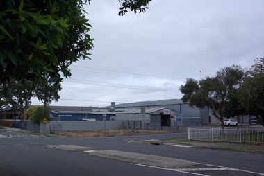
Photograph - Photograph - Colour, Industrial Buildings on the corner of Yarrowee Street and Vickers Street, Sebastopol, 2020, 07/04/2020
Colour photographs of an industrial site on the corner of Yarrowee Street and Vickers Street, Sebastopol. sebastopol, yarrowee street, sebastopol, vickers street, sebastopol -
 Federation University Historical Collection
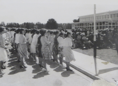
Image, Opening of the Ballarat Teachers' College at Gillies Street, 1960, 1960
The Ballarat Teachers' College at Gillies Street was opened by the Minister of Education, Mr Bloomfied MLAFive images from the opening of the new Ballarat Teachers' College building in Gillies Street.ballarat teachers college, gillies street, opening, celebration, tom turner, a.h. ramsay -
 Federation University Historical Collection
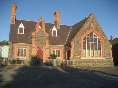
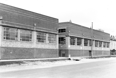
Photograph - Photograph - Black and White, Ballarat School of Mines Buildings, Albert Street, c1970
Kenneth Joynson Flecknoe joined the Ballarat School of Mines Council in 1979 becoming its 11th President in 1981. He joined the Ballarat Courier newspaper in 1953 as company secretary, becoming General Manager in 1966. Flecknoe joined the board of directors in 1968 and was managing director from 1969 until his retirement in 1987. Flecknoe was chairman of the Ballarat Broadcasters Pty Ltd (3BA), of the gateway Publishing Company which published newspapers in Ararat and Stawell and of the Ballarat Publishing Company which published Ballarat News, and was formerly deputy chairman of associated Broadcasting Services Ltd (BTV6 Ballarat and GMV Shepparton). He was also Chairman of the advisory board of Ballarat's St John of God Hospital. Flecknoe's contribution to the Royal South Street Society, of which he was a past president, and a committee member since 1961, was rewarded with life membership. He was also a life member of the Ballarat Historical Park Association (Sovereign Hill). The Ballarat School of Mines building in Albert Street was named "Flecknoe" in 1991, three years after Flecknoe's death.Three photographs showing a Ballarat School of Mines building on Albert Street. .1) Ballarat School of Mines Building, Albert Street .2) View of Carpentry Building looking towards Albert Street .3) Building on the Ballarat School of Mines Building (Possibly the former caretaker's cottage), near Albert Streetballarat school of mines, albert street, flecknoe, carpentry, vocational skills, ken flecknoe, flecknoe building -
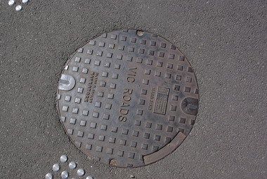 Ballarat Heritage Services
Photograph - Photograph - Colour, Clare Gervasoni, Vicroads 'Cap' on the Corner of Sturt Street and Doveton Street, Ballarat, 2011, 29/12/2011
Colour photograph of a metal VicRoads plaque on the corner of Sturt Street and Doveton Street, Ballarat. sturt street ballarat, vicroads -
 Sunbury Family History and Heritage Society Inc.
Photograph, Rosa McCall, Ligar Street, February 2014
This is a view of Ligar Street looking towards Riddell Road and opposite the tennis courts, taken in February 2014. The weatherboard Californian cottage was probably built in the 1920s and is one of a few other cottages of this style in Sunbury.A non-digital coloured photograph of a street with a fenced in area adjacent to a weatherboard cottage. A pedestrian crossing is in the foreground and a small white car is parked further down the street. There are trees visible in the distance.ligar street, sunbury, californian cottages