Showing 1809 items matching "planning and development"
-
 Greensborough Historical Society
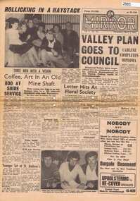
Newspaper, Elliott Provincial newspapers Pty Ltd, Diamond Valley Mirror May 4, 1965, 04/05/1965
Contains article "Valley plan goes to Council", discussing the development of the Plenty Valley, north of Greensborough.Early plan submitted to Diamond Valley Council in 19658 p.greensborough -
 Federation University Historical Collection
Book, Camp Street Precinct Ballarat Conservation Management Plan (Draft), 1999, 10/1999
The conservation management plan was commissioned by the City of Ballarat to assist in the process of planning for the future management and development of the Camp Street precinct, having particular regard for the Camp Street Arts and Education Precinct.White, soft covered, spiral bound book relating to Ballarat's Camp Street Precinct. Contents include: Methodology, buildings and site layout. ballarat, camp street, clare gervasoni, ballarat fine art gallery, art gallery of ballarat, old colonists' hall, former ballarat mining exchange, former state offices, former police court, former police station, former police barracks, old police station, arts academy, archaeology, conservation management plan -
 Clunes Museum
Document - BUSINESS PLAN, 2007
PREPARED FOR THE CREATIVE CLUNES WORKING PARTY UNDER THE AUSPICES OF THE CLUNES TOURIST AND DEVELOPMENT ASSOCIATION INC WITH FUNDING FROM THE DEPT OF PLANNING & COMMUNITY DEVELOPMENT BY VISION BUSINESS CONSULTING, NOVEMBER 2007BUSINESS PLAN FOR CREATIVE CLUNESlocal history, documents, plans, -
 Federation University Historical Collection
Document, History of the Ballarat Technology Park, Oakbank
The Ballarat Technology Park is associated with Federation University Australia. The first stage commenced on 03 August 1989 when the first sod was turned by Hon, David White, Minister for Industry, Technology and Resources. John Beaumont was the Director of the Ballarat Technology Research and Development Park in 1989.Twenty items relating to the History of the Ballarat Technology Park as collected by John Parkin. .1) Handwritten notes by John Parkin on the history of the Ballarat Technology Park .2) Letter from A.E. Helyar (Shire of Buninyong Secretary), 08 March 1988 .3) Shire of Buninyong Minutes 07 June 1988 .4) Development of High Technology Activity by Jack Barker .5) Definition of a Technology Park by Derek Woolley .6) Shire of Buninyong minutes 28 June 1988 .7) Shire of Buninyong minutes 19 July 1988 .8) Invitation to a reception to commemorate the inauguration of the Ballarat Technology Park (John Parkin) by Shire of Buninyong President Cr Judith Coull to be held on 03 August 1989. .9) Invitation to a reception to the Ballarat Technology Park (John Beaumont) .10) Ballarat Courier article 04 August 1989 .11) Draft letter to Professor Geoffrey Blainey from John Parkin .12) Letter to the Editor from John Parkin, 18 December 2000 .13) University of Ballarat Development Appeal, 04 November 1994 .14 & .15) Invitation to installment dinner to celebrate the installation of Professor Geoffrey Blainey as Chancellor of the University of Ballarat to be held in the Union Building (now Albert Coates Building), Mt Helen campus .16) Letter to the editor from John Parkin .17) Letter from John Beaumont, 25 November 1994 .18) Invitation to the opening of the ISSC Southern Region Data Centre to be held on 24 November 1995. .19) Letter from Barry Traynor, 13 December 1995 .20) Planning Scheme information relating to the LaTrobe Research and Development Zone. .1) 2nd May 2005 History of Technology Park (I.T. centre) The history of the Technology Park started back in the mid-1980s. At the time I was a Buninyong Shire Councilor and as such I was Buninyong's representative on the then Ballarat Development Committee. At one of our meetings we received a request for information on a suitable site for a technology park. The requirements were for a site adjacent to a tertiary institution, secluded for security purposes and large enough to contain such a development. The next morning I contacted our Shire Engineer at the time, Newell Barrett and we drove around the area we both agreed that the current site was the most suitable we saw to meet the requirements. At the time it was owned by George Morrison. however the original enquiry to the B.D.C. came to nothing but the Shire Council and the B.D.C. decided to investigate the possibility of the site becoming a technology Park and information was collected. At about this time Mr Morrison put the property on the market and it was bought by a Ballarat builder, Mr John Beaumont, with the idea of developing it as a residential area. Council then arranged a meeting with Messrs Morrison and Beaumont to discuss the matter. I remember Mr Morrison saying he did not care what was done with it he just wanted to sell it and move down to the coast. Mr Beaumont, on the other hand, said he wasn't ready to retire yet and the idea interested him. As a result a committee consisting of the B.C.A.E., B.D.C. and Buninyong Shire Council (and Mr Beaumont) was formed to plan the development and rezone the area to technology park. It was previously zoned residential land and would seem to have been suitable for sub-division and residential development - its close proximity to the College being a major factor in its favour. The point of this is if Mr Beaumont had insisted on pursuing his original plan and had opposed the rezoning, I am quite confident he would have won an appeal at the A.A.T . (Administrative Appeals Tribunal - forerunner of V.C.A.T.) and the I.T. centre would not have got off the ground and the area would be covered with houses. But Mr Beaumont did go into the project with enthusiasm and the first stage was commenced on the 3rd August 1989 when the first sod was turned by Hon. David White, the Minister for Industry, Technology and resources (See the Courier 4th August 1989) Mr Beaumont went overseas to study similar parks and look for tenants. Unfortunately government did not support the project as they have now and apparently Mr Beaumont was ahead of his time for the private sector so Mr Beaumont could not continue the development and the site eventually passed to the College. I personally think more could have been done ... The work done by the Buninyong Shire Council and Ballarat Development Committee seems to have been forgotten as according to the Courier December 21, 2000 we are told the Park opened in 1995 as a joint venture between the City and the University. As a former Councillor said to me on the day "What happened to the plaque David White unveiled in 1989!" If there is any other information you want, please contact me. You may use my file for reference. Kind regards John Parkin PS I always felt a bit guilty that I encouraged John Beaumont and he was left in the lurch. ballarat technology park, parkin, john parkin, helyar, barker, woolley, shire of buninyong, beaumont, blainey, geoffrey blainey, southern region data centre, greenhill enterprise centre, stan jeffrey, jeffrey, john beaumont, david white -
 Greensborough Historical Society
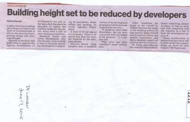
Newspaper clipping, Building height set to be reduced by developers, 17/06/2015
A proposed development at 4-6 Flintoff Street is to have its plans amended to reduce the height of the building.News clipping, black text.flintoff street greensborough, town planning, banyule city council -
 Federation University Historical Collection
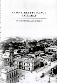
Book - Report, Camp Street Precinct Ballarat Conservation Management Plan, November 1999
This report was prepared for the City of Ballarat to assist in the process of planning for the future management and development of the Camp Street precinct.214 page report with spiral binding and a cover featuring a black and white image of the Ballarat Post Office, Ballarat Free Library and Ballarat State Offices. The report includes information on buildings in the Camp Street precinct including Art Gallery of Ballarat, old Colonists' Hall, former Police Court, former Police Station, Former Police Barracks, Government Camp (1852-1864), etcballarat fine art gallery, art gallery of ballarat, ballarat old colonists hall, ballarat former library, ballarat old court house, old ballarat police station, former ballarat post office, ballarat market reserve, ballarat benevolent reserve, bones building, old colonists hall, former ballarat call room, former ballarat police court, archaeology, aledandria tea room, former lister and angel warehouse, pratts warehouse, cms, conservation management plan, old colonists' hall, old colonists' association -
 Wodonga & District Historical Society Inc
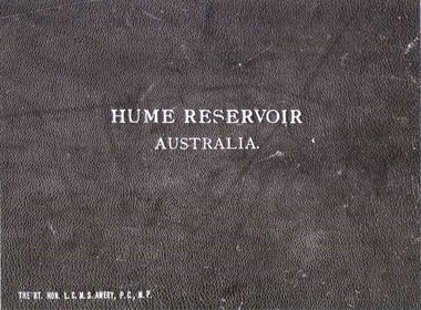
Album - Hume Reservoir Australia Album - Cover, Department of Public Works, N.S.W, 1927
This set of photos is from a leather bound album bearing the inscription "HUME RESERVOIR AUSTRALIA" plus 'The Rt. Hon. L. C. M. S. Amery, P. C., M .P.' all inscribed in gold. It was presented to The Rt. Hon. L. C. M. S. Amery, P. C., M. P, Secretary of State for Dominion Affairs on the occasion of his visit to the Hume Reservoir on 2nd November 1927. To ensure preservation of the album and its contents, the images and information pages have all been digitised. It is assumed that over the past 70 to 80 years there has been some loss of contrast due to fading, and probably detail. Thus, each photo was enhanced in several steps. Digitalisation of the album was completed by Eric Eulenstein in Wodonga in April 2002. The position of Secretary of State for Dominion Affairs was a British cabinet-level position created in 1925 and responsible for British relations with the Dominions — Canada, Australia, New Zealand, South Africa, Newfoundland, and the Irish Free State — and the self-governing Crown colony of Southern Rhodesia.This album is of local and national significance as it documents the planning and development of the Hume Reservoir up to 1927. It was the largest water reservoir in the British Empire. The album records the pioneering engineering work that went into its construction.Leather bound cover of the album of photos and information documenting the planning and development of the Hume Reservoir up to 1927. It was presented to The Rt. Hon. L.C.M.S. Amery, P.C., M.P, Secretary of State for Dominion Affairs on the occasion of his visit to the Hume Reservoir on 2nd November 1927. Embossed in gold in centre of cover "HUME RESERVOIR/AUSTRALIA" At bottom left "The Rt. Hon. L.C.M.S. Amery, P.C., M.P."hume reservoir australia, the rt. hon. l.c.m.s. amery -
University of Melbourne, Burnley Campus Archives
Plan, Wilsons Promontory8119-I and Glennie 8119-IV, 1971
State Aerial Survey Plan of Wilsons Promontory and Glennie. Dated 1971. Provisional Compilation of Sheets 8119-I and 8119-IV from Commonwealth Department of National Development Photography for the Department of Crown Lands and Survey Victoria. Students made excursions to Wilsons Promontory.wilsons promontory, glennie group, anser group, bass strait, aerial survey -
 Melbourne Tram Museum
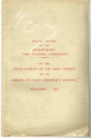
Document - Report, Metropolitan Town Planning Commission, "Metropolitan Town Planning Commission - Darling to Glen Waverley Railway - 1927", May. 1927
... "Metropolitan Town Planning Commission - Darling to Glen...Metropolitan Town Planning Commission ...Report - 20 pages + 5 Maps stapled and then glued bound within a light green grey light card folder titled "Metropolitan Town Planning Commission - Special Report on the Development of the area serviced by the Darling to Glen Waverley Railway - 1927". Report looks the development that could be undertaken along the proposed Glen Waverley rail line, its town planning, Garden City type layouts, rail level crossings, new arterial roads, open spaces, financial arrangements, sewerage and water supply, zoning, legislation and conclusion. Dated 6/5/1927. Plans show possible garden city type layouts, arterial roads, possibilities within existing sub-divisions. Note that Mr. Strickland was a member of the Commission undertaking this work.Has in ink on the bottom edge "17th June 1919"trams, tramways, mmtb, tramways, development, town planning, glen waverley, darling -
 Federation University Historical Collection
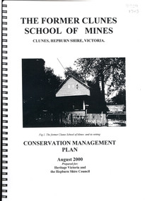
Book, The Former School of Mines Clunes Conservation Management Plan, 2000, 08/2000
The Clunes School of Mines was a campus of the Ballarat School of Mines. The conservation plan was prepared for Hepburn Shire Council and Heritage Victoria to guide the future management of the former Clunes School of Mines in Service Street, Clunes, The building was opened in February 1892 as the Clunes branch of the Ballarat School of Mines, and ceased operating in June 1893.Spiral bound black and white copy of the Conservation Plan for the Clunes School of Mines. Contents include the history, chronology development, context of the building and site, current and past function of the building, original fabric, impact of later alterations, condition of the building, statement of significance, conservation action plan, caring for the site, collecting and keeping information, structural engineers Report, Department of Lands Survey 1955, Memorandum of Agreement 1956.ballarat school of mines, clunes school of mines, australian native association, ana, australian native association clunes branch, eygelaar inner spring mattress factory, clunes infant welfare centre, clunes angling club -
 Melbourne Tram Museum
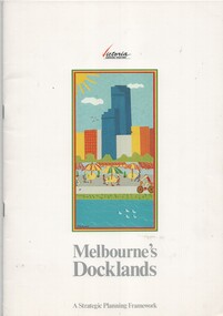
Document - Report, Ministry for Planning and Environment, "Melbourne's Docklands - A Strategic Planning Framework", 1989
... "Melbourne's Docklands - A Strategic Planning Framework"... Planning...Ministry for Planning and Environment. ...Report - 32 A4 pages centre stapled colour printed on gloss paper, titled "Melbourne's Docklands - A Strategic Planning Framework", dated August 1989. Has a foreword by Tom Roper Minster for Planning and Environment. The report with a table of contents looks at the development of the Victoria Docklands area to the west of the railway yards. Has a good colour photograph of the area. Includes public transportation links using trams.trams, tramways, docklands, planning, melbourne, new track, public transport -
 Eltham District Historical Society Inc
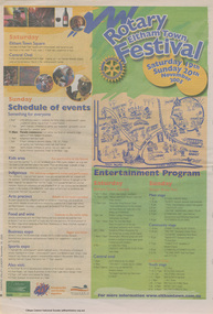
Newspaper clipping, Program; Rotary Eltham Town Festival 19-20 November 2005, Diamond Valley Leader, 16 November 2005, p8, 2006
News articles on reverse (p7) include stories on Councillors refusing plans on a three-storey development in Ramptons RoadNewsprintdevelopment application, eltham festival, eltham north, nillumbik shire council, ramptons road, program -
 Greensborough Historical Society
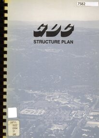
Book - Planning Document, TTM Consulting Pty Ltd, Greensborough District Centre: Structure plan, 1989, 1989_07
A summary of investigations into impacts of the Greensborough District Centre in 1989, with plans for the development of the East side of Main Street Greensborough.91 pages text and black and white line drawings. One colour fold out map. Black plastic binding and clear plastic cover. greensborough district centre, main street greensborough, greensborough plaza -
 Robin Boyd Foundation
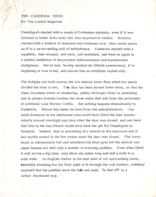
Document - Manuscript, Robin Boyd, The Canberra Virus, Jul-64
Description of Canberra's development after Walter Burley Griffin's urban planning and the impact it has had on other architects.Original manuscript published in The London Magazine Vol.4, No.4, pp.78 - 82Typewritten (c copy), pencil edits to 1, quarto, 8 pages. (Two copies)canberra, walter burley griffin, national capital development commission, robin boyd, manuscript -
Friends of Ballarat Botanical Gardens History Group
Work on paper - Ballarat Botanical Gardens by Lake Wendouree, The Fernery (Palm House), C 2002
The article was produced by the Ballarat City Council entitled "The Fernery". It deals with developments, purpose and plans for the Fernery from 1955.This page testifies to the importance Ballarat City Council attached to the Fernery around the turn of the century and the plan to make it "the next landmark project", after the Australian Ex-POW Monument was finished in 2004.One page of 6 paragraphs in font 12.Logo, central top of page, "Ballarat Botanical Gardens by Lake Wendouree" in black and white.john garner, doctor, john garner collection, ballarat botanical gardens, the fernery, friends of ballarat botanical gardens, ballarat botanical gardens masterplan and management strategy, ballarat city council, gardens, ballarat -
University of Melbourne, Burnley Campus Archives
Administrative record - Garden Management and Maintenance, Victorian College of Agriculture and Horticulture, Miscellaneous Planning Documents, C.1997
... Miscellaneous Planning Documents ...master plan, burnley gardens, garden maintenance, garden management, vcah, herb garden -
 Ringwood and District Historical Society
Newspaper, Scrapbook Clipping, Library Collection, Ringwood, Victoria
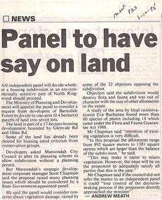
Newspaper Clipping from "The Mail", 3-10-95. P23. By Andrew Meath. Panel to have Say on LandAn independent panel will decide whether a housing subdivision in an environmentally sensitive part of North Ringwood should proceed. The Ministry of Planning and Development will appoint the panel to consider a request from developers of Barnsdale Forest to divide one acre (0.4 hectares) parcels of land into 7 lots -
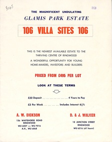 Ringwood and District Historical Society
Flyer, Land Sale Brochure, Glamis Park Estate (Wantirna, Vic.) - 1959
Street name Carnarvon Avenue on the subdivision plan became Selkirk Avenue at some stage during or subsequent to development of the Estate.Bi-folded advertisement for sale of residential allotments, including summary of subdivision features and local facilities.Subdivision includes Wantirna streets - Wantirna Road, Carnarvon Avenue, Inchcape Avenue, St Thomas Avenue, St Davids Drive, Dudley Avenue, Angus Avenue. Agents - A.W. Dickson, 136 Whitehorse Road, Ringwood, Telephone WU 6007, WU 7016, A.H. WU 6868. D. & J. Walker, 18 Junction Street, Ringwood, Telephone WU 6516 (all hours). -
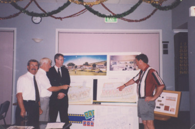 Lakes Entrance Historical Society
Photograph - Golf Houses residential development Golf Links Road Lakes Entrance Victoria, Lakes Post Newspaper, 1/12/1999 12:00:00 AM
Golf Houses residential development Golf Links Road Lakes Entrance Victoria - Proposed plan shown on notice boardColour photograph showing Matt Martino Bill Daniel Mike Hurst and Gary Jeal at the launch of Golf Houses residential development Golf Links Road Lakes Entrance Victoriatourism, land development -
Port Melbourne Historical & Preservation Society
Plan - CD-ROM, State Savings Bank, Montague Housing Development
COPYRIGHT PUBLIC RECORDS OFFICE Set of plans and documents relating to the State Savings bank, Montague Housing Development, in Gladstone St, Montague. This was an initiative of South Melbourne City Council to replace slum housing in Montague, 1935-40 .01 - The DVD which contains all the information.built environment - domestic, state savings bank of victoria -
 Greensborough Historical Society
Booklet - Report, TTM Consulting Pty Ltd, Shire of Diamond Valley: Greensborough District Centre: "East-side" development application: traffic & parking impact report, 1992, 1992_04
A summary of traffic ad parking impacts of the Greensborough District Centre in 1992, with plans for the development of the East side of Main Street Greensborough.14 pages text and 11 pages black and white line drawings. greensborough district centre, main street greensborough, traffic, parking -
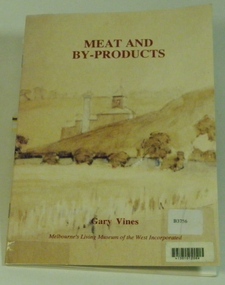 Melbourne's Living Museum of the West
Booklet, Melbourne's Living Museum of the West, Meat and By-Products, 1993
The meat industry and animal by-product works of Melbourne's West, in the series "Interpreting the Cultural Landscape", with the assistance of the Department of Planning and Development, VictoriaThe Australian Meat Preserving Company was established on the banks of the Maribyrnong River in 1870 on the site of boiling works dating from the 1840s.32 page booklet, A5, Cover illustration of Raleigh's boiling down works on the Maribyrnong River, from water-colour by Greeves C. 1850s Title: Meat and By-Products Author: Gary Vines Melbourne's Living Museum of the West Inc.western suburbs, meat industry -
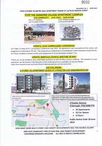 Greensborough Historical Society
Document - Planning Document, Diamond Village Apartment Complex, 2019
A collection of documents discussing opposition to the Diamond Valley Apartment Complex, a high-rise apartment development planned for Nepean Street Greensborough.13 pages of Text with coloured photographs and mapdiamond village apartment complex, building permits, nepean street greensborough -
Glen Eira Historical Society
Map - Kilvington Baptist Girls Grammar School
One hard copy and one photocopy of Kilvington Baptist Girls Grammar School Planning brief dated October 1982. The brief details the current needs of the school and has been written to spell out a forward plan for development in the foreseeable future. It includes data on the current forecast enrolments at primary and secondary levels as well as the current and future use and development of the buildings and their use. Author of the brief is unknown.kilvington baptist girls grammar school, schools, ormond, lillimur road, walsh street, ormond girls school, kilvington girls grammar school, leila road, katandra road, ulupna road -
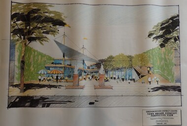 Greensborough Historical Society
Planning Document, Shire of Diamond Valley, Greensborough District Centre, Town Square Concept Plans 1991, 1991_02
Plans and concept drawings for the proposed development of the Greensborough District Centre, Town Square. Shire of Diamond Valley existed from 1964 to 1994.7 plans and 2 concept drawings, black and coloured ink on white paper.shire of diamond valley, greensborough -
 Kew Historical Society Inc
Plan - Subdivision Plan, Six Big Home Sites, Camberwell North, c.1936
Subdivision plans are historically important documents used as evidence of the growth of suburbs in Australia. They frequently provide information about when the land was sold on which a built structure was subsequently constructed as well as evidence relating to surveyors and real estate and financial agents. The numerous subdivision plans in the Kew Historical Society's collection represent working documents, ranging from the initial sketches made in planning a subdivision to printed plans on which auctioneers or agents listed the prices for which individual lots were sold. In a number of cases, the reverse of a subdivision plan in the collection includes a photograph of a house that was also for sale by the agent. These photographs provide significant heritage information relating house design and decoration, fencing and household gardens.A subdivision in what is currently Balwyn, but which was advertised as being in Camberwell North. The subdivision included six allotments facing Buchanan Avenue and Houghton Street. The subdivision was to the east of the Pointed Firs Estate (1936). In addition to the intrinsic value of this subdivision plan, it also reveals information about the development of transport infrastructure in this area. The subdivision plan notes that the Tramways Board has approved the extension of the tram route past the current terminus at Balwyn Road.subdivision plans - camberwell -
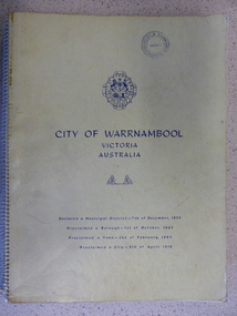 Warrnambool and District Historical Society Inc.
Book, City of Warrnambool, 1961
This book is a report on the development of the city of Warrnambool in 1960. The seven sections it covers are, 1 Town Planning and beautification 2 Culture and Education 3 Town promotion and tourism 4 Recreation and youth work 5 Industrial development 6 Town Development 7 Community organization. There is a very comprehensive study on each of the sections. The population at this time was 15697. This report has social, historical and research significance. It is a comprehensive study of the city as it was in 1960, listing clubs, organisations schools and sporting clubs. It provides information on any development such as the Olympic pool and St Pius X1 school in West Warrnambool and the building of the Pontings store on the Lava St corner. It relates facets of our history which have changed dramatically in the last 60 years with the report on Peter Hand’s tobacconist having 3 vehicles covering the district travelling 4700 miles a month selling cigarettes. It provides statistical evidence for organisations such as Australia Post, train and freight services and the hospitals.Large yellow soft card cover with spiral binding. Title and city details are printed in blue on cover with city logo towards top of front cover. Pages are not numbered. It is divided into seven sections, each denoted by blue page with section title printed in blue on page.Circular stamp on front cover,” Warrnambool Standard Proprietary Limited.” K L Arnel town clerk. warrnambool 1960, warrnambool directory 1960 -
Moorabbin Air Museum
Book - Recounting training scheme development as well various personal stories, AIRCREW UNLIMITED The Commonwealth Air Training Plan during World War 2, John Golley, AIRCREW UNLIMITED The Commonwealth Air Training Plan during World War 2, 1993
Recounting training scheme development as well various personal stories, AIRCREW UNLIMITED The Commonwealth Air Training Plan during World War 2Cover jacket showing black outline drawing of pilots scrambling to aircraft, Tiger Moth in background, Harvard passing over, dark brown / blue background, white/yellow writing.non-fictionRecounting training scheme development as well various personal stories, AIRCREW UNLIMITED The Commonwealth Air Training Plan during World War 2 -
Port Melbourne Historical & Preservation Society
Archive - BayLinks, Ian McKAY Archive, 1985 - 1992
These papers document Ian McKAY's involvement in the above. Filed & indexed by J BOLITHO.Ian McKAY key documents and themes - BayLinks, concept plan for Port Phillip Boulevard, info sheet from Swallow & Bain Street Residents Association, material about ESS, Port Melbourne Citizens Action Group, a response to the Bayside Development project, National Trust submissions (1985-92).public action campaigns, local government - city of port melbourne, town planning - proposals shelved - bayside, melbourne harbor trust - port of melbourne authority, ian mckay, janet bolitho -
Port Melbourne Historical & Preservation Society
Document - Application for Planning Permit Rex Hotel, City of Port Phillip, 15 Oct 1996
Two A4 sheets of white paper giving details of the Notice of Application for Planning Permit for the Rex Hotel, 145 Bay Street, Port Melbourne. The application by Lex Carter Pty Ltd was for the use and development of the land for the purpose 'of a place of assembly(club)". The conditions of license are set out on the 2nd page. Rex Hotel 70 pokies Liquor License 9am - 1am Pencil sketch of layout of cnr Bay & Graham Streets.business and traders - hotels, rex hotel, city of port phillip