Showing 244 items
matching residential planning
-
 Lakes Entrance Historical Society
Book, Tambo Shire, Shire of Tambo Planning Report, 1990
The Guide to planning and co-ordinating the development of Rural Residential and general rural subdivision through the municipality of Tambo Shire for the next five yearslocal government, township -
 Ringwood and District Historical Society
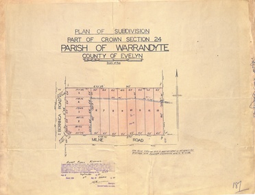
Map - Plan of Subdivision, Part of Crown Section 24, Parish of Warrandyte, County of Evelyn - 1951
Survey map of residential allotments in Berringa Road and Milne Road, Park Orchards, Victoria. Russell Francis Kinnane, Licensed Surveyor, 4th October, 1951. -
 Ringwood and District Historical Society
Map - Plan of Subdivision, Part of Crown Section 24, Parish of Warrandyte, County of Evelyn - undated, circa 1951
Survey map of residential allotments in Milne Road, east of Berringa Road, Park Orchards, Victoria. -
 Ringwood and District Historical Society
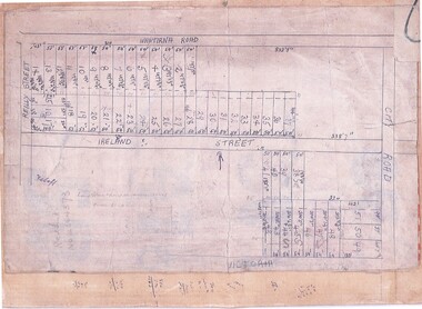
Document, Subdivision Map (Undated) - Ringwood, Victoria
... Hand-drawn copy of subdivision plan showing numbered...-drawn copy of subdivision plan showing numbered residential ...Hand-drawn copy of subdivision plan showing numbered residential allotments with property dimensions.Map includes Wantirna Road, Ireland Street, City Road and Victoria Street (later Regina Street), Ringwood, Victoria.