Showing 272 items matching "residential services"
-
 Kew Historical Society Inc
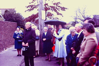
Slide - Ceremony: Bodalla Nursing Home, 32 Walpole Street, 1980
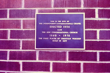
‘Bodalla’ at 32 Walpole Street, Kew was opened in August 1980 and run by Uniting Church Aged Care Services. It was located on the site of the first Congregational Church in Walpole Street which had functioned from 1860 to 1978. The church was demolished to create the nursing home, which was itself sold and redeveloped after 2009 as residential sites. In 2004, Denise Deerson interviewed residents of the aged care facility and published the interviews as a book - ‘Active Lives : life stories from Bodalla’. This slide, and a number of others were donated by Joy Stewart in 1980. The slides came from the collection of Joy Stewart’s mother, Mrs C Dickins.35mm colour transparency of a ceremony at the Bodalla Nursing Home [now demolished] at 32 Walpole Street, Kew during which a plaque was unveiled commemorating it as the site of the historic Congregational Church (1860-1978), demolished 1979. Kew Historical Society members participated in planning for and unveiling of this commemorative plaque. khs - slides, kew congregational church -- walpole street -- kew (vic.), bodalla nursing home - 32 walpole street -- kew (vic.), aged care services -- kew (vic.), nursing homes -- kew (vic.) -
 Kew Historical Society Inc
Slide - Ceremony: Bodalla Nursing Home, 32 Walpole Street, 1980
‘Bodalla’ at 32 Walpole Street, Kew was opened in August 1980 and run by Uniting Church Aged Care Services. It was located on the site of the first Congregational Church in Walpole Street which had functioned from 1860 to 1978. The church was demolished to create the nursing home, which was itself sold and redeveloped after 2009 as residential sites. In 2004, Denise Deerson interviewed residents of the aged care facility and published the interviews as a book - ‘Active Lives : life stories from Bodalla’. This slide, and a number of others were donated by Joy Stewart in 1980. The slides came from the collection of Joy Stewart’s mother, Mrs C Dickins.35mm colour transparency of a ceremony at the Bodalla Nursing Home [now demolished] at 32 Walpole Street, Kew during which a plaque was unveiled commemorating it as the site of the historic Congregational Church (1860-1978), demolished 1979. Kew Historical Society members participated in planning for and unveiling of this commemorative plaque. khs - slides, kew congregational church -- walpole street -- kew (vic.), bodalla nursing home - 32 walpole street -- kew (vic.), aged care services -- kew (vic.), nursing homes -- kew (vic.) -
 Vision Australia
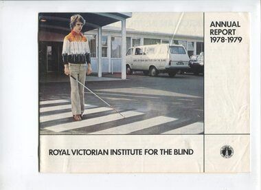
Administrative record - Text, Royal Victorian Institute for the Blind annual report 1978-1979, 1978-1979
Articles in annual report include: a public educational program speaking to doctors, nurses, teachers, occupational therapists, service clubs and rotated displays through public libraries, RVIB stand won a prize in Community and welfare section at the Royal Melbourne show, difficulties with Mr and Mrs Tye's estates are resolved and plans to build an educational complex at Romsey, acknowledgement of volunteer involvement with Cubs, Guides, Ham Radio and Model Train clubs available to residential children, and the United Kingdom Hotel in Clifton Hill raised over $8000 to become the top hotel fundraiser again.1 volume of text and illustrationsroyal victorian institute for the blind, corporation records -
 Vision Australia
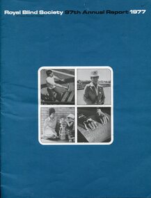
Administrative record - Text, 97th Annual Report Royal Blind Society of N.S.W. (1977), 1977
Articles in the annual report include: increased funding from state government, possibility of sustained funding in providing a public library service, success of low vision clinic and need to increase opening times to accommodate demand, decision to move to standard cassette, change in direction by providing support for children to stay in family unit and community kindergartens rather than placement in a separate kindergarten program or residential care, introduction of Closed Circuit TVs into the workshop, winning a 2 year contract with Australia Post to provide bicycles and an order from Dubbo Zoo for family cycles and tandems, formation of RPH with a trial broadcast and radio license application made, and the Society held it's first Open Day.1 volume of text and imagesroyal blind society of new south wales, corporation records -
 Vision Australia
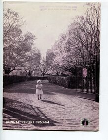
Administrative record - Text, Royal Victorian Institute for the Blind annual report 1963-1964, 1966
Overview of events that occurred in 1963-4 : six children in residence at Deaf-Blind unit, a Residential Rehabilitation Centre for blind adults was opened and has catered for more than 20 clients, visit from Dr Richard Hoover, school children have participated in camps, visiting a Russian whaling ship and a poultry farm, and performing in a radio program, 10 students gained Honours in pianoforte AMEB, and one former student graduated with a Bachelor of Law from Melbourne University. Everton Soccer team visited the school, Swish was introduced and APEX adopted talking books as it's Association Service.1 volume of text and illustrationsannual reports, royal victorian institute for the blind -
 Vision Australia
Booklet - Text, The Association for the Blind needs $750,000 - Give Thanks For Your Sight
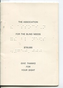
Overview of the work done by the Association for the Blind and contact details for all those involved in managing the appeal. The 'Sight, Kooyong' appeal aimed to raise $750,000 to provide additional facilities at Kooyong, Oak Park, Geelong, Ballarat, Mildura and Shepparton, expand the George Vowell Day Centre and establish residential facilities at Mt Eliza, expand welfare and rehabilitation services across Victoria, increase work done in the Low Vision Clinic and expand awareness in the prevention of blindness.1 booklet with braille and print on front covernon-fictionassociation for the blind, elizabeth maxwell, neil maxwell, fundraising -
 Melton City Libraries
Photograph, Former Rockbank Beam Wireless Station, Unknown
Built in 1926 and opened in 1927, it was the receiving station of the Australian Imperial Wireless Service. In 1927, provided the nation’s first radio communication with Britain and North America. The station closed in 1969.Former residential quarters of the Australian Beam Wireless Receiving Station at 653-701 Greigs Road East, Mt Cottrell.misc. -
 Phillip Island Conservation Society Inc.
Work on paper - Photocopy of newspaper cutting, Melbourne Sun newspaper, "PHILLIP ISLAND SPECIAL PREPARED BY BILL HITCHINGS", 29.08.1969
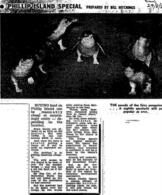
This article by journalist Bill Hitchings describes the state of the land market and cost of transporting building materials, Phillip Island, late 1960s. At that stage a number of outlying residential estates had been created, especially on Phillip Island South Coast and at Cowes West. While blocks of land on the outlier estates were very cheap and poorly serviced, the Cowes blocks were selling at $3000 per residential block. Hitchings quotes the owner of the Hollydene motel, Reg Orr, as saying that when the new bridge opens shortly he did not expect it to create a rush of visitors or residents.Bill Hitching was a well-known Melbourne journalist. This article gives an idea of land values on Phillip Island in the late 1960s, the fact that business owners were prepared to upgrade and expand their businesses to cater for extra potential demand on accommodation, and the strong identification of Phillip Island with the Phillip Island Penguin Parade in the minds of the general public in Melbourne. The significance of the new Phillip Island bridge to Phillip Islanders and visitors, and the cost of the bridge, are also outlined. Reg Orr was highly active in the business community of that era on Phillip Island. The Hollydene motel was a well-known Phillip Island accommodation venue.T-shaped article cutting with large image at top of article, dark due to poor photcopy. Double collumn text under photo clearly readable. Black and white.Sun/29/8/6 (?) Probably: Melbourne Sun newspaper, 29 August, 1969phillip island, phillip island tourism, development, hollydene motel, reg orr, phillip island penguin parade, land values, phillip island first bridge, phillip island 2nd bridge, transportation costs -
 Wodonga & District Historical Society Inc
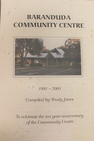
Booklet - Baranduda Community Centre 1991 - 2001, Trudy Jones
Baranduda is a rural area and, since the 1970s, a rural and residential locality formed under the authority of the Albury Wodonga Development Corporation. It is near the junction of Yackandandah Road and the Kiewa Valley Highway, 10 km south-east of Wodonga. This publication was compiled to celebrate the first 10 years of the Baranduda Community Centre. It documents the Centre's origins and anecdotes about its establishment and key personalities involved. Today it provides a variety of educational, recreational, leisure, cultural, social and community support programs including children's services, maternal and child health and immunisation clinics.non-fictionBaranduda is a rural area and, since the 1970s, a rural and residential locality formed under the authority of the Albury Wodonga Development Corporation. It is near the junction of Yackandandah Road and the Kiewa Valley Highway, 10 km south-east of Wodonga. This publication was compiled to celebrate the first 10 years of the Baranduda Community Centre. It documents the Centre's origins and anecdotes about its establishment and key personalities involved. Today it provides a variety of educational, recreational, leisure, cultural, social and community support programs including children's services, maternal and child health and immunisation clinics.baranduda communiity centre, baranduda -
 Kew Historical Society Inc
Photograph - Former Willsmere (Kew) Mental Hospital
The former Kew Lunatic Asylum, was commenced in 1856 and opened in 1872. At various stages of the institution's history it was named the Kew Lunatic Asylum (1872-1956), Kew Mental Hospital (1956-1960s), Willsmere Mental Hospital (c.1960s-1982), and the Willsmere Unit (1982-1989). Most of the records relating to this former institution are held by the relevant Government Department or by the Public Record Office Victoria. Due to the location of this institution in Kew, the Kew Historical Society also holds an extensive photographic archive as well as significant collections of personal papers collected by staff who worked there.This photograph is one of a series donated to the Society by the photographer, taken following the closure of the Willsmere Unit, and before its redevelopment as a private residential complex. The series is historically significant in that it depicts interior and exterior views of the former institution that were subsequently altered or demolished during redevelopment. A number of the 'views' are socially significant as they allow us to examine the ways in which public institutional architecture in the 19th and 20th centuries responded to the needs of those with perceived mental health issues. Colour snapshot of a part or section of the former Willsmere (Kew) Mental Hospital, taken following its decommissioning and before its sale and redevelopment.kew lunatic asylum, kew mental hospital, willsmere mental hospital, willsmere unit, health & human services, mental health, institutional architecture -
 Ringwood and District Historical Society
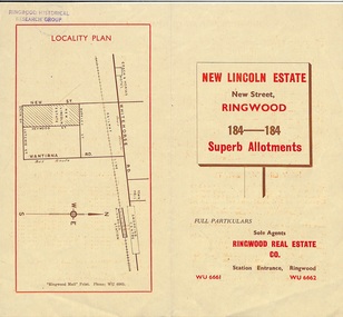
Document - Folder, Land Sale Brochure, New Lincoln Estate, Ringwood, Vic. - circa 1960. Also 1951 newspaper advertisement
Bi-fold advertisement for sale of residential allotments - New Lincoln Estate, New Street, Ringwood, with summary of local facilities and services, locality plan, layout of sub-division, and price list. Also an advertisement from Ringwood Mail dated 12 July 1951. Subdivision includes New Street, Heywood Street, Barkly Street, Keith Grove, Maurice Avenue, Inez Avenue, Catherine Street, Neville Street, Neale Grove (later Heather Grove), and Sylvia Grove. Agent - Ringwood Real Estate Co., Station Entrance, Ringwood. (Phone) WU 6661, WU 6662.Accompanying handwritten sales notes researched in 2024 by Richard Carter - Carter Real Estate ... "Maurice Ashkanasy KC CMG owned the rectangular estate located between New, Barkly, Heywood Streets and Sylvia Grove in South-West Ringwood. It was given the name "The New Lincoln Estate". It was first advertised around July 1951 as "48 superb allotments", through Ringwood Real Estate (Station Entrance). A sub-divisional plan from CE Carter showed 152 blocks with 60-foot frontages and varying between 110 and 150 feet in length. Later, in 1954 house and land packages were offered through William White in Elsternwick - "Three modern bedrooms, large lounge-dining-room, kitchen with dinette, nicely equipped bathroom - £2,685 to £2,762, deposit £300". The roads were created and named after family members - Neale (later Heather) Grove - after Maurice's son Neal Mark Ashkanasy. The street was later re-named Heather Grove after Maurice's wife, Heather Helen Ashkanasy (Epstein), who passed away in 1999, aged 95. Neville Street - after Marice's other son, Aaron Solomon Neville Ashkanasy known as Neville. Catherine Street and Inez Street - after Heather's mother Catherine Inez Epstein. Maurice Avenue - after Maurice Ashkanasy, vendor. Keith Grove - after Keith Epstein. ..." -
 Ringwood and District Historical Society
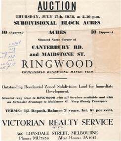
Flyer - Land Auction Sale, Ten Acres, Maidstone Street Ringwood - 1958
Double sided page advertising Auction, Thursday, July 17th, 1958, (Approx.) 10 Acres, north corner of Canterbury Road and Maidstone Street, Ringwood. Agents - Victorian Realty Service Pty.Ltd., 360 Lonsdale Street, Melbourne, Phone MU7858, After Hours JA1045. Reverse side shows map of proposed subdivision by K.J. Noonan & Co., Surveyors & Engineers, 495 St.Kilda Rd, Melbourne, marked subject to approval of all interested statutory authorities.Residential zoned subdivision land for immediate development. Extensive frontage to Maidstone Street. Accompanying handwritten annotation "10 acres offered as a whole, later re-subdivided". -
 Ringwood and District Historical Society
Document - Folder, Land Sale - Monterey Park Subdivision, Warrandyte Road, Ringwood North, Vic. - 1981
Foolscap manilla folder containing double-sided flyer advertising residential subdivision development, including outline of local facilities and services, with locality map and layout of Monterey Park streets. Subdivision includes Parkwood High School, Tortice Drive, Heape Way, Appleberry Place, Stringybark Court, Conifer Court, Crawley Grove, Monterey Close (later Monterey Place), Lucy Place, Middlebrook Drive, Gahnia Close, Glanfield Court, Cone Close, Jull Parade, Pinus Close (later Pinetree Court), Radiata Close, Old Warrandyte Road, and entry from Warrandyte Road. Vendor - Jennings Industries Limited, 690 Springvale Road, Mulgrave, 3170, Phone 5618000. A4 enclosures with tables showing each allotment List Price, Builders Price, Cash Price and Terms Price. Information page headed "Form of Restrictive Covenant to be incorporated in Transfer" specific to Certificates of Title. Restrictive Covenant (summary): (Name/s) "... will not erect or construct or cause to be erected or constructed on the land hereby transferred (a) Any front boundary fence, other than a fence which does not exceed one metre in height unless the same is set back as least 1.5 metres from the front boundary and the same is effectively screened from that boundary by the planting of trees, shrubs or plants. (b) Any side boundary fence other than a fence which is set back at least 1.5 metres from the front boundary on which does not exceed 1 metre in height within 1.5 metres of the front boundary. (c) For a period of 5 years from the date hereof, any building on the said land unless and until the Plans and Specifications thereof have first been approved by the said Residential Developments Pty. Limited. (d) For a period of 2 years from the date hereof whilst the said land remains vacant any Signboard or Notice advertising the sale of the said lot or any other lot. These covenants shall appear on the Certificate of Title to issue for the said land and run with the land." -
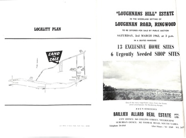 Ringwood and District Historical Society
Document - Folder, Subdivision Auction - Loughnans Hill Estate 1962, Ringwood, Victoria
Double-sided bifold page advertising auction on Saturday 3rd March, 1962 - 13 residential allotments in Hearthside Court and 6 shop sites in Loughnan Road, with map of subdivision, terms of sale, and summary of features and services. Adjoining service station shown on accompanying Plan of Subdivision - Part of Crown Allotment 28 Parish of Warrandyte, also showing location of property known as "Hearth", hence Hearthside Court.Auctioneers - Baillieu Allard Real Estate Pty Ltd., 360 Collins Street, Melbourne, and 302 Toorak Road, South Yarra. Telephone 24-4365, After hours XU1549, WL2471. -
 Ringwood and District Historical Society
Flyer, Residential Land Auction - Heatherdale Road, Ringwood - 1973
Single-page advertisement for auction on Saturday 15th September (1973) - 9 residential allotments on Heatherdale Road, Ringwood. Includes summary of local services and facilities, and map of area showing Verdale State School, Manhattan Hotel-Motel, and directional arrow 3/4 mile to railway station (Heatherdale) to the north.Agent - L.J. Hooker Vic. Limited, Hooker House, 327 Collins Street, Melbourne 3000, Telephone 62 0181, A.H. 232 3481, Telegrams HOOKCO. -
 Eltham District Historical Society Inc
Document - Folder, Jim Connor et al, Eltham Gateway, 1987
The Eltham Gateway Group (EGG) was established about 1987 by some Eltham residents concerned for the development of the Eltham Gateway, defined as that historically and environmentally sensitive region of land along Main Road, Eltham extending from the roundabout at Fitzsimons Lane to Dudley Street, Eltham. The gateway was a unique urban area with a strong sense of character that provided a distinctive entrance to the Eltham Town Centre. The intention of this group was to support development that preserved both the natural and historic features of the gateway region. It encouraged development sympathetic to Eltham’s traditional association with the arts and natural environment. The group was initiated in response to a planning application in December 1986 to redevelop the then Mobil service station site at 729 Main Road, Eltham on the corner of Brougham Street. This group worked with and encouraged the Eltham Shire Council to consider rezoning to protect the gateway area. A detailed Eltham Gateway Study undertaken by Tract Consultants assisted with the establishment of the Eltham Gateway Zone, the Eltham Gateway Policy and the Eltham Gateway Design and Siting Guidelines. The State Government subsequently agreed to a planning amendment to rezone the land from a Residential Zone C to an Eltham Gateway Zone under the Eltham Planning Scheme. While zoning changes over the years have altered the mix of permitted uses within this area the Eltham Gateway still looks and feels like a predominately residential style precinct, even where non-residential type uses operate. EGG was followed by the establishment of the Eltham Protection Society in about 1989 to respond to community planning issues beyond the area of the Eltham Gateway and in effect took over the role from the EGG. Jim Connor President Eltham District Historical Society 4 July 2022 During 1986/87 I was a community member on the Shire of Eltham’s Community Consultative Committee involved with the Eltham Gateway Study, which led to the establishment of the original Eltham Gateway Zone, under the then Eltham Planning Scheme The Eltham Gateway Group was the pioneer community action group dedicated to protecting the character of the Eltham Gateway. It was succeeded by the Eltham Protection Society. When the Shire of Eltham Offices were demolished by the unelected Commissioners of Nillumbik Shire Council in July/August 1996, significant community upset and protest led to the establishement of the Eltham Gateway Action Group (EGAG) which in present day form has evolved into the Eltham Community Action Group (ECAG) focussing on issues throughout Eltham and not just the Eltham Gatewayeltham community action group, eltham gateway, eltham gateway action group, eltham gateway design and siting guidelines, eltham gateway group (egg), eltham gateway policy, eltham gateway study, eltham gateway zone, eltham planning scheme, eltham protection society, jim connor, michael wilson, rodger dalling, tony mcmanus -
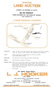
 Ringwood and District Historical Society
Document - Folder, Kinton Court Estate Subdivision, Ringwood, Victoria - 1975
Manilla folder containing plan of residential subdivision, with price list and summary of services available. Subdivision includes Oban Road, Jeffrey Drive, Flora Court and Kinton Court. Timbered land - 22 sewered allotments. Agents - C.E. Carter & Son RESI., 122 Whitehorse Road, Ringwood (Phone) 8706211. -
 Vision Australia
Audio - Sound recording, No vision, no vote, no way: 139 years of fighting for equality by Anna Fairclough, 2005
In 2005, archivist Anna Fairclough gave a historical presentation about the subsidiaries of the newly formed Vision Australia. She covers from the beginnings of the RVIB, RBS, AAFB and Victorian Braille Writers Association, the establishment of schooling, residential homes, employment skills and the changing ways of fundraising. Other milestones such as the lack of voting rights, payment of travel bonds for those who wished to cross state borders, the establishment of blind cricket, expansion of services outside capital cities as well as the impact of Tilly Aston and Helen Keller are mentioned in this brief talk on past 140 years.1 x MP3 file of a historical presentation by archivist Anna Faircloughassociation for the advancement of the blind, association for the blind, royal blind society of nsw, royal victorian institute for the blind, tilly aston, helen keller, anna fairclough -
 Bendigo Military Museum
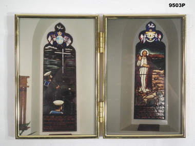
Photograph - PHOTOGRAPH, FRAMED
Items form part of the collection of "William Anthony THEODORE DSM". Refer catalogue No. 7926P for service details.Gold metal frame with hard cardboard inserts with hanging hooks attached. Folds over with two photos inside in each half. Both with glass protection. Both photos taken inside of a Church of two windows with lead light image. First - picture of two sailors looking up at a cross in the sky from deck of a ship and some writing at bottom. Second - Picture of Christ giving a sermon to some soldiers hiding in a trench with some writing below.Sticker on back identifying Bill Theodore, a resident of Victoria Heights Residential Care.tobruk, church, william anthony theodore dsm -
 Vision Australia
Photograph - Image, St Kilda Road building in 2010, 6/1/2010
In 2007, Vision Australia sold it's iconic 557-563 St Kilda Road site. The historic bluestone building was in need of renovation and repair, had limited space for staff and clients and with more demand for services in suburban and regional areas, did not meet the needs of the national organisation. The purchaser was mainly interested in the Ormond Hall section, which they sub-divided off and sold to the tenant of the Belgian Beer Cafe. The remainder of the site was then sold on to another developer. Unable to quickly proceed with their plans on developing the site for residential buildings, the site fell into some disrepair in the interim which was when these images were taken. Later the site was sold again and residential buildings now occupy part of the block. 20 images taken of and from St Kilda Road buildingroyal victorian institute for the blind, buildings, myer house, ferguson and urie -
 Ringwood and District Historical Society
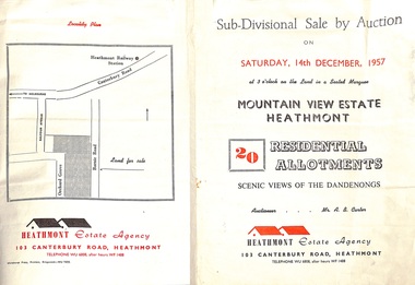
Flyer - Land Sales Brochure, Sub-Divisional Sale by Auction - Mountain View Estate, Heathmont, Victoria - 1957
Bi-fold pamphlet advertising auction of 20 residential allotments on Saturday, 14th December, 1957, with description of services available and finance terms. Subdivision inclues Orchard Grove and Barnic Road. Agent - Heathmont Estate Agency, 103 Canterbury Road, Heathmont, Telephone WU6808, after hours WF1488. Auctioneer Mr. A.B. Carter. Accompanying Parish of Ringwood survey map with cardboard backing - Part of Crown Allotment 14B, includes handwritten price notations for each allotment. -
 Ringwood and District Historical Society
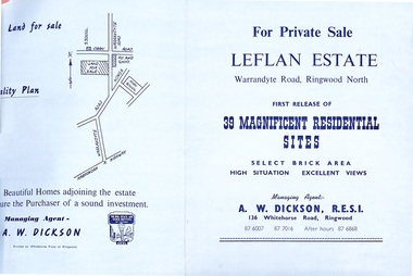
Document - Folder, Land Sale - Leflan Estate, North Ringwood, Vic. - circa 1967
Bi-fold land sale advertisements for stages 1 and 3 releases of residential allotments in Leflan Estate, Ringwood North, circa 1965-1967. Brochures include area map, layout of the estate, and summary of local facilities and services, with separate attachment listing lot number prices for 2nd and 3rd releases.Subdivision includes Melview Drive, Leslie Grove, Leflan Close, Warrandyte Road and Lockhart Street. Agent - A.W. Dickson, R.E.S.I., 136 Whitehorse Road, Ringwood. (Phone) 870-6007, 870-7016, After hours 870-6868. -
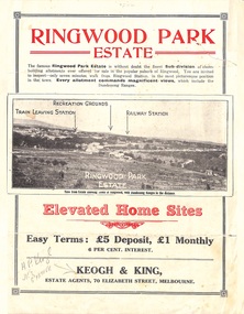 Ringwood and District Historical Society
Flyer, Sub-divisional residential land sale advertisement - Ringwood Park Estate, Ringwood, Vic. - circa 1922
Folded double-sided page with black and white photographs of local views with black and red print advertising elevated home sites, including terms of sale, locality map, and description of local facilities and services, with blocks marked as SOLD subsequent to auction sale December 1922. (See Record ID no.5249)Subdivision includes Wonga Road (later Loughnan Road), William Street, Andrew Street, Munro Street and Harrison Street. Estate Agents - Keogh & King, 70 Elizabeth Street, Melbourne, Telephone 6938. -
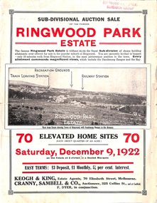 Ringwood and District Historical Society
Flyer, Sub-divisional auction sale advertisement - Ringwood Park Estate, Ringwood, Vic. - 1922
Folded double-sided page with black and white photographs of local views with black and red print advertising auction sale on Saturday 9th December, 1922, - 70 residential home sites, including terms of sale, locality map, and description of local facilities and services. Subdivision includes Wonga Road (later Loughnan Road), William Street, Andrew Street, and Harrison Street. Vendors Solicitors - Rigby & Fielding, 60 Market Street, Melbourne. Estate Agents - Keogh & King, 70 Elizabeth Street, Melbourne, Telephone 6938. Auctioneer - Cranny, Sambell & Co., 325 Collins Street, Melbourne, Telephone Central 5067 and 5077. -
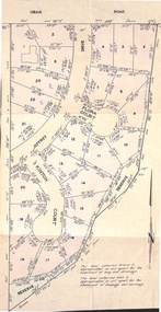
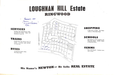 Ringwood and District Historical Society
Document - Folder, Subdivision Map - Loughnan Hill Estate, Ringwood, Victoria - circa 1960
Open centre page of land sale brochure glued to manilla folder. Map of residential and shop sites in Burlock Road (later Burlock Avenue), Adolphson Avenue and Felix Crescent, Ringwood, with summary of estate facilities and local services. Agent - T.G. Newton.(Page glued to manilla folder prevents access to front page for further sale information) -
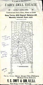 Ringwood and District Historical Society
Flyer, Residential Land Sale Sub-division - Fairy Dell Estate, Warranwood, Vic. - circa 1950s
Land sale advertisement for 50 home sites with map of Sub-division showing layout of streets and allotments, summary of local features and services and terms of sale, and copy of sectional map of Crown Allotments 20 & 21B Parish of Warrandyte also showing layout of Sub-division.Subdivision includes Grandview Grove (later Bemboka Road), Merrill Crescent and Kerry Road, Warranwood. Estate Agents - V.C. Swift & Son R.E.S.I., Main Street, Croydon, Phone 20. Solicitors - Morgan, Fyffe & Mulkearns, 108 Queen Street, Melbourne. Handwritten 1970s real estate price notations for some blocks. -
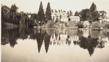 Bendigo Historical Society Inc.
Photograph - FORTUNA COLLECTION: FORTUNA, c1940
Black and white photo. Fortuna Villa and lake, looking from far side of lake to Villa. Inscriptions/Markings: C1940. KALMA FILM SERVICE, BENDIGObuildings, residential, fortuna villa, kalma film service, bendigo -
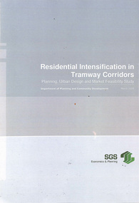 Melbourne Tram Museum
Document - Report, SGS Economics and Planning, "Residential Intensification of Tramway Corridors", May. 2009
Report - 130 pages - wire bound, plastic and card covers, titled "Residential Intensification of Tramway Corridors", prepared for the Department of Planning and Community Development by SGS Economics and Planning March 2009. Look at the development along the Nicholson St and the West Preston lines in particular. Does a detail examination of the development opportunities, including major sites that were available at the time. Does not appear to address how to capture the value of having a tram line along these areas or how to provide additional services. Development has taken place since along these and other corridors. Final Report. Table of contents and Executive Summary scanned.trams, tramways, tram routes, east preston, nicholson st, passengers, development -
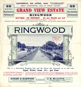 Ringwood and District Historical Society
Flyer, Subdivisional Land Auction Sale Brochure, Grand Central Estate, Ringwood, Vic. - 1924
Refer also to Reg. No. 5148 for 1925 auction sale of land also titled Grand View Estate situated further south in Ringwood.Double sided multi-folded page advertising public auction sale on Saturday, 5th April, 1924, of residential allotments highlighting local facilities, services and layout of the estate. Includes panoramic view over the estate and other local photographic images. Additional clipped copy of subdivison map on blue cardboard backing includes real estate sales notations.Subdivision includes Whitehorse Road, Rupert Street, Herbert Street. and Leonard Street. Agents - Knight & Harwood, 315 Collins Street, Melbourne, Phone 10615, 10616 Central, in conjunction with J.B. McAlpin, Opposite Railway Station, Ringwood. Phone Ringwood 7. -
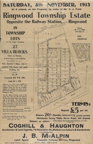 Ringwood and District Historical Society
Flyer, Auction Sale Advertisements - Ringwood Township Estate, Ringwood, Victoria - 1913
Advertisements for auction sale of retail and residential blocks opposite the Ringwood Railway Station on Saturday, 8th November, 1913, showing subdivision layout, terms of sale, and summary of local features and services. Auction at 3 o'clock on the property by order of Mr. O.J. Pratt - 18 township lots, 27 villa blocks, also weatherboard butcher's shop with 5-roomed weatherboard house and good stabling, and 5-roomed new weatherboard villa. Subdivision includes Station Road (later Warrandyte Road), Pratt Street, and Whitehorse Road. Agents - Coghill & Haughton, 79 Swanston Street, Melbourne, Auburn & Canterbury, in conjunction with J.B. McAlpin, Opposite Railway Station, Ringwood. Additional 2 partially trimmed copies allotment maps on cardboard backing with handwritten sales notations.