Showing 3448 items
matching road bridges
-
 Eltham District Historical Society Inc
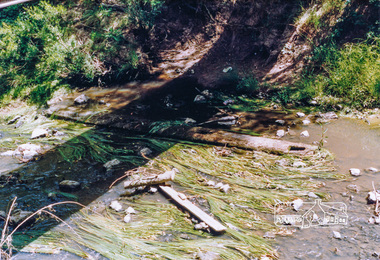
Photograph, Cross beam from old timber Main Road bridge over the Diamond Creek, 1992, 1992
... Cross beam from old timber Main Road bridge over the... Road trestle bridge lying in creek bed. It is downstream from... melbourne bridges diamond creek main road eltham south Two colour ...Two colour photographs of old cross beam from original Main Road trestle bridge lying in creek bed. It is downstream from the current re-structured bridgebridges, diamond creek, main road, eltham south -
 Eltham District Historical Society Inc
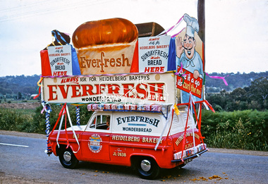
Photograph, Heidelberg Bakery display, Ersilac Parade, Main Road, Eltham, c.1960, 1960c
... Heading south along Main Road approaching Bridge Street... melbourne Heading south along Main Road approaching Bridge Street ...Heading south along Main Road approaching Bridge Street. Registration GIB is c.1955Digital file only (Wes's 35mm)don muir collection, heidelberg bakery display, ersilac parade, main road, eltham, c.1960 -
 Glenelg Shire Council Cultural Collection
Photograph - Photograph - Bridge Construction, n.d
... road/Otway street bridge, looking east.... of the Tidewater road/Otway street bridge, looking east. Photograph ...Port of Portland Authority Archivesport of portland archives, tidewater road, otway street bridge -
 Sunbury Family History and Heritage Society Inc.
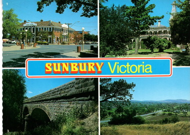
Postcard, Newcolourvue Productions Pty.Ltd, Sunbury Victoria, c1970s
... Bluestone Road Bridge... bluestone road bridge over Jacksons Creek and a view of the township... bluestone road bridge over Jacksons Creek and a view of the township ...The four photographs on the post card are well-known places in the town. They are the 1930s Royal Hotel building which was build on the same site of the original building on the corner of Evans and Brook Streets, Rupertswood Mansion, built 1874-45, the historic bluestone road bridge over Jacksons Creek and a view of the township in the 1970s taken from Francis Boulevard.The four views of Sunbury give an overview of the township in the 1970s before the increased development took place from the 1980s onwards.A coloured collection of four non-digital photographs of places in Sunbury in post card format. The edges of the post card are rippled. the back of the card gives details of the places as well as the maker.Sunbury Victoriaroyal hotel, rupertswood mansion, bluestone road bridge, sunbury, post cards -
 Orbost & District Historical Society
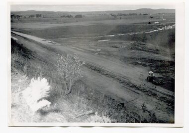
black and white photographs, first half 20th century
... Four black / white photographs of road construction... photographs of road construction and rail bridges. black and white ...3255.1 is a photograph of the Princes Freeway construction of the roadway embankment at the foot of Newmerella Hill. 3255.2 is of the construction of the roadway, the Princes Freeway looking down from Newmerella toward Orbost. 3255.3 shows the Princes Freeway from Grandview , Newmerella, and shows the southern end of Ashby's Gulch with its bridge. 3255.4 is of the Princes Freeway showing the bridge across Ashby's Gulch and a train on the railway viaduct. Ashby's Gulch is named for the Ashby family. The Ashby family was one of the early settlers in Orbost at Newmerella. Roy Ashby, son of James Rowland Ashby and Edith Annie Hall, was born on 21 Nov 1892 in Orbost. Victoria. Australia and died in 1942 in Orbost. Victoria. Australia at age 50. Roy married Elsie May Stephens, daughter of James Stephens and Sarah Taylor, in 1920 in Victoria.Australia. Elsie was born on 15 Sep 1898 in Beaconsfield Tasmania.Australia and died in 1974 in Orbost Australia at age 76. Their children were: Roy Ashby, William Henry Ashby, Cordelia Valma Ashby and Edith Ashby. This photograph is associated with the construction of the main roads into Orbost. It is also connected to the Orbost to Bairnsdale Railway.Four black / white photographs of road construction and rail bridges.road-construction-newmerella princes-freeway-newmerella ashby's-gulch-newmerella orbost-railway -
 Whitehorse Historical Society Inc.
Photograph, Railway Bridge, Brunswick Road, Heatherdale - Now Cochrane Street - runs through to Orient Avenue, C.1958
... Railway Bridge, Brunswick Road, Heatherdale - Now Cochrane...Black and white photo of Railway Bridge, Brunswick Road... Bridge, Brunswick Road, Heatherdale. Railway Bridge, Brunswick ...Black and white photo of Railway Bridge, Brunswick Road, Heatherdale.o'rourke, l. -
 Clunes Museum
Photograph, CIRCA 1900
... BLACK AND WHITE PHOTOGRAPH , TAKEN FROM CRESWICK ROAD... , TAKEN FROM CRESWICK ROAD, SHOWING GOVERNMENT BRIDGE AND BIBLE ...BLACK AND WHITE PHOTOGRAPH , TAKEN FROM CRESWICK ROAD, SHOWING GOVERNMENT BRIDGE AND BIBLE CHRISTIAN CHURCH.local history, photography, photographs, bridges -
Coal Creek Community Park & Museum
Cordial extract, Iona Products Co. Pty Ltd
... . Iona Products Co. Pty Ltd, 63 City Road (Princes Bridge...Coal Creek Community Park & Museum 12 Silkstone Road ...Two rectangular shaped orange coloured cardboard boxes with flip tops, with text and decoration in red, orange and black.Iona Imitation Cordial extract concentrated lemon flavour. Iona Products Co. Pty Ltd, 63 City Road (Princes Bridge) Melbourne. -
 Ringwood and District Historical Society
Photograph, Eastfield Road Railway Bridge, Ringwood East, Victoria
... Eastfield Road Railway Bridge, Ringwood East, Victoria...Eastfield Road railway bridge looking east- 1 photograph...Eastfield Road railway bridge looking east- 1 photograph ...Black and white photographs : 3 imagesEastfield Road railway bridge looking east- 1 photograph taken on 1/09/74 and 2 photos taken on 5/10/74 -
 Orbost & District Historical Society
black and white photographs, 25.11.1976
... at the official opening of the current Snowy River road bridge. Included... at the official opening of the current Snowy River road bridge. Included ...These photographs were taken on November 25, 1976 at the official opening of the current Snowy River road bridge. Included in the photographs are: John Duggan; Pat Hall, C.R.B. chairman, R.E.V. Donaldson (3240.7) and J.A.Rafferty, the state minister for Transport, who cut the ribbon (3240.8). Di Young and Cheryl Dusting (3240.9) distributed souvenir information pamphlets to official guests. The Snowy River road bridge is one of four built as part of the 8.4 km project spanning the Orbost flood plains. The Snowy River bridge and another over the nearby Ashbys Gulch are among the 10 longest bridges in Victoria, being the eighth and fifth longest respectively. The new bridge removed through traffic from Orbost township crossing the Snowy River 45 m downstream of the old bridge.This bridge is the fourth to provide a crossing to the township of Orbost. (info from CRB NEWS No. 34. DECEMBER, 1976) These photographs are pictorial records of a significant event in Orbost's history.Eleven black / white photographs all related to the official opening of the current Snowy River Bridge. Details are in catalogue folder.snowy-river-bridge -
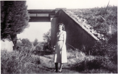
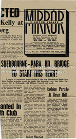 Eltham District Historical Society Inc
Newspaper - News Clipping, Diamond Valley Mirror, Sherbourne-Para Rd. Bridge To Start This Year?, Diamond Valley Mirror, Wednesday, 4th Sept., p1, 1963
... of the new Sherbourne Road - Para Road bridge (Montmorency... of the new Sherbourne Road - Para Road bridge (Montmorency ...Original clipping from the front page of the Diamond Valley Mirror Vol 5, No 235, Wednesday, 4th Sept., 1963 reporting on Eltham Council news that a move to commence construction of the new Sherbourne Road - Para Road bridge (Montmorency) will commence later in the financial year. Commencement would be subject to the requirements of the railways. Secondary news item included relates to a fashion parade at Briar Hill.Newsprint clippingmontmorency, sherbourne road, para road, bridge, briar hill, bridge construction, diamond valley mirror, railway bridge -
 Clunes Museum
Photograph, APPROX. 1900
... BRIDGE CRESWICK ROAD AND BUTTER FACTORY BRIDGE ACROSS TULLAROOP... ROAD AND BUTTER FACTORY BRIDGE ACROSS TULLAROOP CREEK. GASWORKS ...THE PHOTOGRAPH WAS TAKEN FROM CREEK PARADE GOVERNMENT BRIDGE CRESWICK ROAD AND BUTTER FACTORY BRIDGE ACROSS TULLAROOP CREEK. GASWORKS..1 ORIGINAL SEPIA LANDSCAPE OF CLUNES MOUNTED ON CARDBOARD. GOVERNMENT AND JUBILEE BRIDGES ACROSS CRESWICK CREEK. GASWORKS NEARBY. .2 BLACK AND WHITE COPY OF THE ABOVE PHOTOGRAPH PRINTED ON GLOSS PHOTOGRAPHIC PAPER .3 HAND COLOURED POSTCARD PHOTOGRAPH OF THE ABOVE PHOTOGRAPH .4 TWO POSTCARDS WITH SAME PICTURE .5 FOUR SMALL PHOTOGRAPH COPIES WITH SAME PICTURE.1 ON BACK OF PHOTOGRAPH GASWORKS, BRIDGES AND CREEK. 1900 .3 ON FRONT OF POSTCARD GOV. BRIDGE CLUNESlocal history, photography, photographs, bridges and buildings -
 Halls Gap & Grampians Historical Society
Photograph - Photocopy, C 1930s
... railing. An unsurfaced road crosses the bridge and the area.... An unsurfaced road crosses the bridge and the area is surrounded ...The third Delley's Bridge, a timber and concrete structure with a curved deck, built in 1940. It was situated slightly upstream from the previous bridge. After nearly 50 years of its use, wear and tear necessitated a fourth bridge to be erected in 2001.The picture shows a curving bridge with a wood and wire railing. An unsurfaced road crosses the bridge and the area is surrounded by trees.structures, tents -
 Eltham District Historical Society Inc
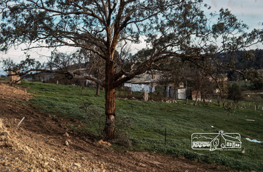
Photograph, Floodwaters, Diamond Creek, Eltham, 1934
... The Diamond Creek in flood near the Main Road bridge... melbourne The Diamond Creek in flood near the Main Road bridge ...The Diamond Creek in flood near the Main Road bridge at Eltham, Victoria. The Yarra also was in flood. In early December 1934 the "Greatest flood in the history of the Yarra" occured, according to The Argus newspaper. Bridges and houses were swept away with hundreds of people left homeless across the state. The historic 1934 flood of the Diamond Creek and Yarra River set the criteria for future planning with respect to flood water rise.This photo forms part of a collection of photographs gathered by the Shire of Eltham for their centenary project book, "Pioneers and Painters: 100 years of the Shire of Eltham" by Alan Marshall (1971). The collection of over 500 images is held in partnership between Eltham District Historical Society and Yarra Plenty Regional Library (Eltham Library) and is now formally known as 'The Shire of Eltham Pioneers Photograph Collection.' It is significant in being the first community sourced collection representing the places and people of the Shire's first one hundred years.Digital image 4 x 5 inch B&W Neg (2 frames on one neg) 9 x 15.5 cm B&W printflooding, eltham, shire of eltham pioneers photograph collection, sepp, diamond creek (river), floods, 1934 flood, diamond creek -
 Melbourne Tram Museum
Drawing, Melbourne & Metropolitan Tramways Board (MMTB), "Footscray - City Tram Schemes - Perspective Overview", Dec. 1947
... and the length of double track. Shows roads, bridges, railway lines... or proposals and the length of double track. Shows roads, bridges ...Drawing - hand coloured - not formally titled - "Footscray - City Tram Schemes - Perspective Overview", shows existing tramways, proposed conversions, four different schemes or proposals and the length of double track. Shows roads, bridges, railway lines, docks, industry location, road cross sections and other planning features. Dated 4-12-1947, drawing No. P10868. Note pdf version of this drawing on the images file, but will not open with dbtext works pdf viewer. Converted to a jpg which does open.On left hand edge on the rear has in pencil - "Footscray - City Tram Schemes - Perspective Overview" P10868 1947 Spare (dup)trams, tramways, footscray, new tramway, north melbourne, spencer st, victoria st, bridges -
 Melbourne Tram Museum
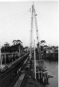
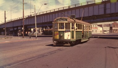
Slide - Set of 3, Keith Caldwell, March 1967?
... shows the St Kilda Road bridge section being constructed c... shows the St Kilda Road bridge section being constructed c ...Set of three Agfa colour blue white plastic mount slides, photo by Keith Caldwell of : .1 - W2 651 outbound on route 15 to St Kilda beach negotiating trackwork at the St Kilda Junction. .2 - view from Upton Road overpass looking east at the Queensway road and tram track construction .3 - ditto, looking west shows the St Kilda Road bridge section being constructed c early, possibly March 1967.1 - "BXBU" and on .3, .1 also has "MBR River" in ink.trams, tramways, st kilda rd, st kilda junction, w2 class, route 15, trackwork, queensway, tram 651 -
 Eltham District Historical Society Inc
Photograph, Fred Mitchell, Site of the new Eltham Town Park, corner of Main Road and Bridge Street, Eltham, 1968, 1968
... Site of the new Eltham Town Park, corner of Main Road and...During the Main Road duplication. Bridge Street... melbourne During the Main Road duplication. Bridge Street ...During the Main Road duplication. Bridge Street in background to the right of picture. Eltham Town Park was later renamed Alistair Knox Park.Digital copy of colour photographfred mitchell collection, 1968, main road, road construction, duplication, alistair knox park, bridge street, eltham town park -
 Ballarat Tramway Museum
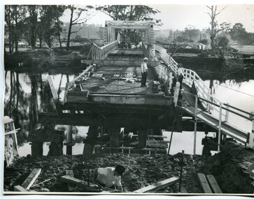
Photograph - Black & White Photograph/s, mid to Late 1965
... to a dual road/tram bridge. The road bridge is in the background... to a dual road/tram bridge. The road bridge is in the background ...Set of two Black and white photographs of the pile driving for the reconstruction of the Maribyrnong River Bridge from a tramway only bridge to a dual road/tram bridge. The road bridge is in the background. On Kodak paper. Photo during the 2nd half of 1965. 1419.1 - Early in the process of pile driving - Bridge tram track has been reduced to single track and the former outbound line is in use for construction purposes. 1419.2 - Roadway west of bridge looking east. Shows temporary single track arrangement which allowed the operating track to switch to the south side when piling completed. W5 682 West Maribyrnong on route 57 coming off the bridge. See P.Winspur note - and Rail News Victoria May 2000, page 50. Features a photograph of a tour on the bridge on 1/10/1966.trams, tramways, maribyrnong river bridge, bridge construction, trackwork, mmtb, tram 682 -
 Eltham District Historical Society Inc
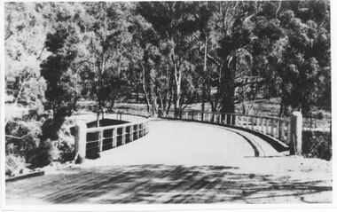
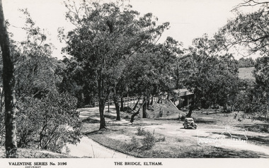
Postcard - Photograph, The Rose Stereograph Company, The Bridge, Eltham, c.1939
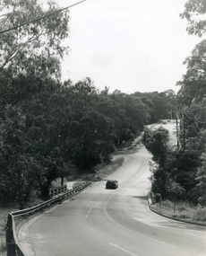
... main road bridge...Looking west across the Main Road Bridge over the Diamond... melbourne Looking west across the Main Road Bridge over the Diamond ...Looking west across the Main Road Bridge over the Diamond Creek at Eltham, c.1939. The car in the foreground, possibly the photographer's, is a Ford Model C Ten built by Ford UK between 1934 and 1937. The Model C was released in Australia in 1935. The Ford Model C Ten is a car that was built by Ford UK between 1934 and 1937. The Model C was released in Australia in 1935 https://en.wikipedia.org/wiki/Ford_Model_C_TenPostcardValentine Series No.3196diamond creek (creek), ford model c ten, main road bridge, postcard, valentine series postcard, bridge, cars, eltham, eltham south, main road, motor vehicles, rose stereograph, rose stereograph company -
 Hymettus Cottage & Garden Ballarat
Work on paper - Bookmark, CRB Cadetships
... -ordinate the construction and maintenance of main roads and bridges...-ordinate the construction and maintenance of main roads and bridges ...The Country Roads Board was established in 1913 to co-ordinate the construction and maintenance of main roads and bridges and it was abolished in 1983 making way for a new body.crb, roads, victoria -
 Ringwood and District Historical Society
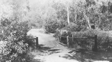
Photograph, Deep Creek bridge and road c.1935
... Deep Creek bridge and road c.1935...Black and white photograph of narrow unmade road showing...Typed below photograph, "Deep Creek bridge and road. c.1935".... Creek bridge and road. c.1935". Black and white photograph ...Black and white photograph of narrow unmade road showing narrow bridge with wooded balustrades. Forested area at edge of roadway.Typed below photograph, "Deep Creek bridge and road. c.1935". -
 Whitehorse Historical Society Inc.
Photograph, Deep Creek Road, Mitcham, 1/01/2001 12:00:00 AM
... Black and white photograph of Deep Creek Road, Mitcham... on left. Photo taken before work started on new road and bridge ...Black and white photograph of Deep Creek Road, Mitcham taken from lower entrance of Schwerkolt Cottage Reserve showing Glenvale Road on left. Photo taken before work started on new road and bridge.deep creek road, mitcham, glenvale road, ringwood -
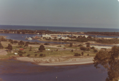 Lakes Entrance Historical Society
Photograph - View of Apex Park, Bullock Island, Lakes Entrance Victoria, 1/04/1979 12:00:00 AM
... Colour photograph taken from Kalimna Heights showing road... Kalimna Heights showing road and bridge to Bullock Island, Apex ...Bullock Island, Apex Park and cars parked on Marine Parade New Works area and Entrance channel in distance Lakes Entrance VictoriaColour photograph taken from Kalimna Heights showing road and bridge to Bullock Island, Apex Park and cars parked on Marine Parade New Works area and Entrance channel in distance Lakes Entrance Victoriaparks, business, islands -
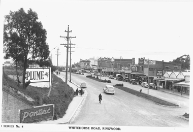 Ringwood and District Historical Society
Photograph, Maroondah Highway Central, Ringwood. Whitehorse Road looking west from Warrandyte Road. c1930's
... Road railway bridge to Ringwood Street.... Road railway bridge to Ringwood Street. Black and white ...Black and white photograph (2 copies)Inscribed on photograph: "Series No 4. Whitehorse Road, Ringwood. Image shows shops on north side of road from Warrandyte Road railway bridge to Ringwood Street. -
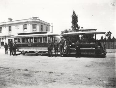 Melbourne Tram Museum
Photograph - Black and White photograph, c1890
... Bridge Road... at the Bridge Road Richmond line terminus with the Bridge Road Hotel... Trams tramways Richmond Bridge Road Crews MTO Co Cable Trams ...Black and white photograph of a cable car set, c1890 at the Bridge Road Richmond line terminus with the Bridge Road Hotel in the background. Has a group of 10 cable tram employees in uniform standing alongside the tram, lettered and detailed decoration on the trailer - No. 18 "Not to be reproduced with permission from the National Library of Australia".On rear in ink "Tram car Melbourne" and a label "Not to be reproduced with permission from the National Library of Australia"trams, tramways, richmond, bridge road, crews, mto co, cable trams, tram 18 -
 Eltham District Historical Society Inc
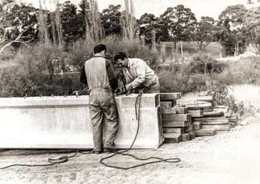
Photograph, Construction of Lower Plenty Bridge, Main Road, c.August 1966, 1966
... Construction of Lower Plenty Bridge, Main Road, c.August...Black and white photograph of construction of new bridge... melbourne bridge construction main road lower plenty plenty river ...Black and white photograph of construction of new bridge, Main Road, Lower Plentybridge construction, main road, lower plenty, plenty river, bridges -
 Orbost & District Historical Society
black and white photograph, 1913
... for the construction of roads and bridges including the Snowy River road... for the construction of roads and bridges including the Snowy River road ...This photograph shows Country Roads Board men clearing a bush track at Hospital Creek. Their vehicle was bogged. The y Roads Board was formed in 1913 1910 it had become apparent that there was a need for a central roads authority to take over responsibility from the Board of Lands and Works for the care and management of the main roads of the state of Victoria. Because there was no consistent and systematic policy for road maintenance Victorian roads were in a deplorable condition. At this time the use of the motor car accentuated the demands for better roads. As a result of these needs the Country Roads Act 1912 was proclaimed in 1913 providing for the establishment of the Country Roads Board as a central road authority with responsibility for those roads within the State considered to be main roads. the C.R.B. was responsible for the construction of roads and bridges including the Snowy River road bridges in Orbost.. This is a pictorial record of transport difficulties in East Gippsland in early 20th century.A large black / white photograph of three men clearing a bush track with a motor vehicle behind them.transport roads road-maintenance country-roads-board -
 Melbourne Tram Museum
Photograph - Set of 3 Colour Negatives, Phil A'Vard, 10/02/1962 12:00:00 AM
... passing under the King St bridge in Queensbridge St, South...Melbourne Tram Museum 8 Wallen Road Hawthorn melbourne ...Set of 3 photographs taken on the AETA tour Sat. 10/2/1962 - Closure of the Local Tram Routes at Footscray. .1 - W4 670 passing under the King St bridge in Queensbridge St, South Melbourne. Has an AETA tour Auxiliary board is showing Special. .2 - ditto, followed by W3 655 crossing the Maribyrnong Road Bridge. .3 - ditto - turning on the reserved track alongside Wests Road. Taken on Perutz film - see 3997 for the AETA Tour circular. and see 5998 for other photographs.trams, tramways, footscray, aeta, maribyrnong river bridge, maribyrnong rd, wests rd, queensbridge st, w4 class, w3 class, tram 670 -
 Eltham District Historical Society Inc
Photograph, Eltham - Floods in 1934
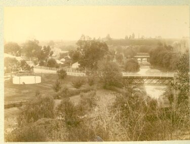
... main road bridge...To the left of picture is the Main Road Bridge over... melbourne To the left of picture is the Main Road Bridge over ...To the left of picture is the Main Road Bridge over the Diamond Creek in Eltham South when the Diamond Creek was in flood. The Yarra also was in flood. In early December 1934 the "Greatest flood in the history of the Yarra" occured, according to The Argus newspaper. Bridges and houses were swept away with hundreds of people left homeless across the state. The historic 1934 flood of the Diamond Creek and Yarra River set the criteria for future planning with respect to flood water rise.This photo forms part of a collection of photographs gathered by the Shire of Eltham for their centenary project book, "Pioneers and Painters: 100 years of the Shire of Eltham" by Alan Marshall (1971). The collection of over 500 images is held in partnership between Eltham District Historical Society and Yarra Plenty Regional Library (Eltham Library) and is now formally known as 'The Shire of Eltham Pioneers Photograph Collection.' It is significant in being the first community sourced collection representing the places and people of the Shire's first one hundred years.Digital image 4 x 5 inch B&W Negsepp, shire of eltham pioneers photograph collection, eltham, diamond creek (river), 1934 flood, diamond creek, floods, main road bridge -
 Orbost & District Historical Society
black and white photographs, February 17 1971
... when the abutment to the Snowy River road bridge was washed... when the abutment to the Snowy River road bridge was washed ...After the damage from the February 1971 floods at Orbost when the abutment to the Snowy River road bridge was washed away a Bailey bridge, portable, pre-fabricated, truss bridge, was put into place to ensure town access, the C.R.B. rebuilt the approach to the bridge driving new piles and constructing the Bailey bridge. They worked late into the night under flood lights to ensure the link from the Orbost township to the Princes Freeway would be open to traffic as soon as possible.These photographs are pictorial records of a significant event in the history of Orbost.Three black / white photographs of a Bailey bridge being erected across a river. 3245.1 and 3245.2 are the same. bailey-bridge orbost-snowy-river-bridge bridge-orbost