Showing 1516 items
matching sand
-
 Clunes Museum
Map - MAPS
ORIGINAL MAP SHIRE OF TALBOT AND CLUNES. LOCALITY PLAN, SEALED ROADS, BITUMEN ROADS, GRAVEL OR SAND ROADS, UNMADE OR PART FORMED ROADS.local history, document, maps, talbot, clunes shire -
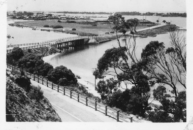 Lakes Entrance Historical Society
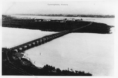
Postcard - Lakes Entrance, Bulmer, H D, 1940c
One Black and White Photograph 6.5 x 11|Two Postcard 8.5 x 14|Two Small format postcard 6 x 9|This is the before paired photograph used in the 150 year, Lakes Entrance 1858-2008 display.|The after paired photograph number is 01156.1 Also one 12 x 16 framed photograph used in room display.Black and white photographic of bridge over North Arm showing the western end of township, sand hummock viewed in distance, Lakes Entrance Victoriatownship, bridges, room display -
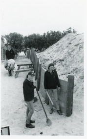 Lakes Entrance Historical Society
Photograph, Lakes Post Newspaper, 1992
Article appeared in Lakes Post 28 October 1992, 'At work on the new retaining wall leading to 90 Mile Beach, staff from the Department of Conservation and Natural Resources, (L-R) Ken Judd, Jason Bice and David Harper'.Black and white photograph of three workers, building pathway and retaining walls through the sand dunes. Coastal banksia in background. Lakes Entrance Victoriawaterfront, parks, room display -
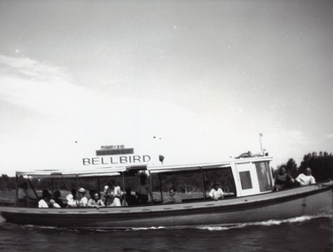 Lakes Entrance Historical Society
Photograph - MV Bellbird, 1940 c
Black and white photograph showing launch Bellbird on Cunninghame Arm. About sixteen people onboard. Sand hummocks in background. Lakes Entrance Victoriatourism, waterways, boats and boating -
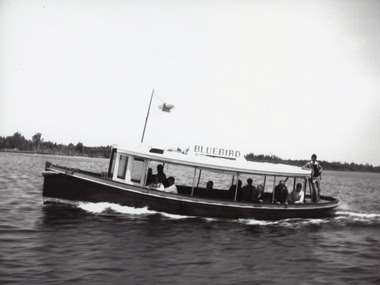 Lakes Entrance Historical Society
Photograph - Bluebird, 1955c
The Bluebird plied Lakes for years until replaced by Peel's StormbirdBlack and white photograph showing launch Bluebird II on Gippsland Lakes. Ten people onboard. Sand hummocks in background. Lakes Entrance Victoriajetties, waterways, boats and boating, tourism -
 Lakes Entrance Historical Society
Photograph - Dredge Sandpiper, L E Tidy Town Committee, Lakes Entrance Victoria, 1994 c
Colour photograph of the entrance sand buildup Kennet Island in waterway dredge Sandpiper working at southwest corner of Bullock Island Lakes Entrance Victoriadredges, waterways, islands -
 Phillip Island and District Historical Society Inc.
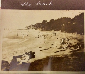
Photograph, The Beach, Cowes, 1926-1926
Sepia photo of the beach, Cowes with many people sitting and walking on sand. Possibly near Cowes Yacht Club looking towards Mussell Rocks.The Beachphotographs, cowes, mussell rocks cowes phillip island, cowes beach -
 Ballarat Tramway Museum
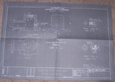
document - Correspondence, Ballarat Tramway Museum (BTM), 31/12/2006 12:00:00 AM
Set of drawings and photocopies of sanding equipment on Ballarat Tramcars, provided to the Launceston tramway Museum for information.Copy of Correspondence with the Launceston Tramway Museum 31/12/2006 concerning sand ejector equipment fitted to Ballarat tramcars. Comprises: Covering letter dated 31/12/2009 Photographs of the Ejector unit with fittings - two views Photograph of the inlet pipe Sketch of the air inlet pipe - prepared by Warren Doubleday Prints of drawings - BA - T7 - 7654 - Ejector for Sand Box, Fabricated type - 21E truck, SEC 1938 - made from scans ex Microfilm BA - T7 - 7647 - Ejector for Sand Box, Brill 21 E Truck - SEC 1938 - cast type.tram, trams, tramcar equipment, sanding equipment, sand ejectors, letters -
 Glenelg Shire Council Cultural Collection
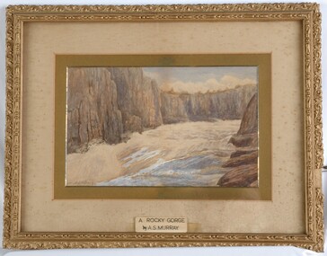
Painting, A.S. Murray, A Rocky Gorge, n.d
CEMA Art collection Previously located in History HouseThe painting portrays a gorge from the perspective of being in the gorge and looking towards the shore. In the foreground is a small body of water with large brown rocks to the right. Yellow sand extends from the rocks around to the left of the water. The sand stretches from the water's edge to the large cliffs in the background that form the borders of the gorge. The work is mounted and framed in an ornate gilded frame with glass.Front: A.S.Murray (signature lower left) A ROCKY GORGE by A.S.MURRAY (sticker - lower centre on glass) Back: 3132 (small yellow sticker) -
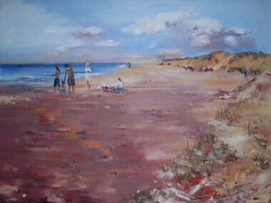 Glenelg Shire Council Cultural Collection
Painting, Julie Kent, Beach Scene, n.d
Hung in CEO's Office 5/9/2003Scene depicting a beach. On the right are sand dunes with grass covering them. On the left is the ocean. The beach runs from foreground left to the upper centre of image, diminishing in size. In centre left of image three standing adult figures and one child stand to the left of a seated figure wearing a red hat. A fishing pole is braced in the sand beside the figure's chair.Front: J Kent (blue paint, lower right) Back: (unknown) -
 Phillip Island and District Historical Society Inc.
Photograph
Part of a collection presented by Miss Edith Elms via Chrisy Northcote.Westernport Bay at low tide showing line of low mangroves 1/3 from bottom. Brown foreground, low line of sand dunes in background.local history, photography, photographs, seascapes, westernport, coloured photograph, san remo -
Glenelg Shire Council Cultural Collection
Slide - Slide - Henty Beach, Portland, PORTLAND BAY, 1960s
Taken by Mr. P.G.W. (Wal) Whitelam in the early to mid 1960'sAlfacolor Slide of Henty Beach, Portland Bay. Paddle Boats on sand on left. Left side cars in carpark. Moored boats & Railway Pier in background.Front: Portland Bay Vi , blue birophotography, slide, 1960s, henty beach, railway pier, portland -
Glenelg Shire Council Cultural Collection
Photograph - Photograph - Henty Beach, n.d
Port of Portland Authority Archivesport of portland archives, henty beach -
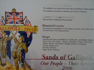 Geelong RSL Sub Branch
Medallions, Sands of Gallipoli, Our People - Their Service 2006, 2006
Medallions depicting Infantry, Medical, Light Horse Artillery, They also Served, Navy. from pictures from collections.This set is Number 1620 of 10,000.7 x round medallions, brass alloy, polished silver, engraved pictires on both sides of the each medallion. Gallipoli Sand from the Gallipoli Peninsula.Images on the medallions are from Australian War Memorial, The New Zealand Army, Subritzky Collection, Digger History Collectiongallipoli, medallions -
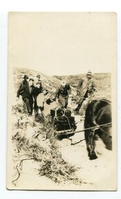 Orbost & District Historical Society
black and white photograph, first half 20th century
Access to the cottages at the lighthouse was difficult and the horse-drawn sled was in use until the 1940s. It was used to haul personal goods as wel as those needing medical attention at far-off Orbost. This photograph could be connected with the Gledhills in the 1930s when a medical emergency necessitated a removal to Orbost. Dr Nettleton was the doctor at Orbost at that time. (there could be a link through donor) Point Hicks is claimed to be Captain James Cook’s first sighting of mainland Australia. The lighthouse was built on the point during 1887 and 1888 and commenced operation in 1890, built from concrete and with timber keepers quarters. It was connected to mains electricity in 1965, and then to solar power recently. Originally access to Point Hicks was by sea. In 1920 a return trip, by land to Cann River, 47 kilometres away from the light station, took two days. By 1946 the journey had been reduced to 36 hours by a combination of horse and jeep. During the early 1950s it was still a 12-hour ordeal. The light no longer works, it was turned off 21 years ago and the Point Hicks lighthouse is now powered by a much smaller, more modern light. the lightkeepers' cottages are used for tourist accommodation.This photograph is associated with Point Hicks, a historically important lightstation in East Gippsland.A small black / white photograph of a horse dragging a sled with suitcases on it. There are seven people walking behind, one holding the reins. They are waalking through a sand dune.on label on back - "Bring Out to Light House keeper from Point Hicks"point-hicks-lighthouse -
 Federation University Historical Collection
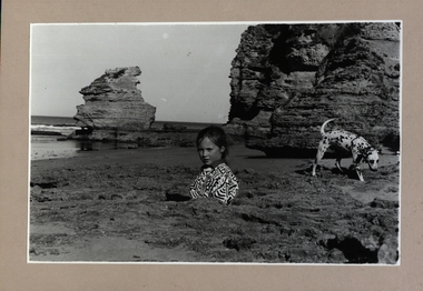
Photograph - Photograph - Black and White, Point Lonsdale, Victoria; Back Beach below the Lighthouse - Girl with a Dog
Work produced during Paul Lambeth's photography class The photograph shows the back beach at Point Lonsdale, below the Point Lonsdale Lighthouse. This area was where many sailing ship coming to Melbourne were wrecked. This was due to the narrow passage through The Rip and the tides at certain times. A Pilot Station was established and ship captains could signal for a Pilot to steer them through The Rip and into Port Philip Bay. Black and white photograph adhered to a beige coloured mount card showing a girl down a hole in the sand with her dalmation dog sitting in a rock pool.paul lambeth, point lonsdale, back beach, sailing ships, ship wrecks, the rip, port philip bay, pilot station, girl, dalmation dog -
 Bendigo Historical Society Inc.
Document - BASIL MILLER COLLECTION: 'DESCRIPTIVE' NOTES - AUSTRALIAN RAILWAY HISTORICAL SOCIETY, 19th March 1966
Typewritten notes on sand, green and white paper. History of locomotives and tramways passenger information sheet for 'North Bendigo Workshop' tour and grand tram tour.person, individual, basil miller -
 Bendigo Historical Society Inc.
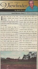
Newspaper - JACK PERRY COLLECTION: SAND BURNERS
Newspaper articles re use of pyrites burners. Describes process involved in the 'sand burning'. Mentions Leggo's burner, California Gully. Bendigo Weekly 28.1.2000person, individual, jack perry -
Port Melbourne Historical & Preservation Society
Photograph - Port Melbourne Beach 1957, 1957
Port Melbourne Beach2 digital images (one annotated) of Port Melbourne Beach 1957. Children playing in sand at jetty at foot of Princes Street, with Harper's factory in background.port melbourne beach -
 National Vietnam Veterans Museum (NVVM)
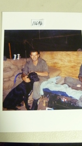
Photograph
Unframed colour photo - Tom (Tuckey) Stevens 1969-70 5RAR Trackers with one of the tracker dogs. Soldier with tracker dog sitting on sand bagstracker dog, 5 rar -
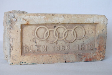 Anglesea and District Historical Society
Olympic Brick 1956, 1956
This is a soft mud sand-stock moulded or semi-dry pressed brick bearing the 5 Olympic rings with the words "GLEN 1956 IRIS" across the bottom.5 Olympic Rings "GLEN 1956 IRIS"olympics 1956, glen iris brick works -
 Heytesbury District Historical Society Inc.
Photograph - PCSLSC - Nippers - Nippers and Leaders at Port Campbell beach
Port Campbell Surf Life saving Club Nippers program 1990'sColour Photograph of 3 leaders. Marina Deppeler , John Ryan , Tom Delaney with group of Nippers sitting on sand in club caps on Port Campbell beach.life saving, port campbell, nippers -
 Lakes Entrance Historical Society
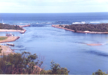
Photograph - The Entrance, Goff, Russell, 1986c
Black and white photograph of the entrance and Bullock Island showing the western end of Bullock Island formed by successive dumping of dredged sand. Lakes Entrance Victoriajetties, ocean, waterways, islands -
 Lakes Entrance Historical Society
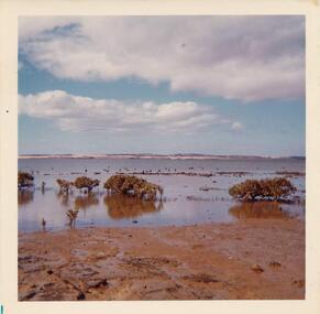
Photograph - Lake Bunga, M Holding, 1990c
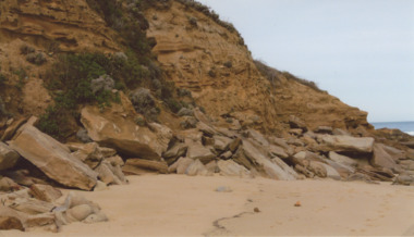
Colour photograph of eastern shore near the entrance to ocean, the low area between upland and sand dune indicating the original waterway Lake Bunga Victoriatopography, waterfront -
 Lakes Entrance Historical Society
Photograph - Norm Arm bridge, Lakes Entrance Victoria c1900, 1900c
Black and white photograph of the bridge over the Norm Arm, showing the town of Cunninghame, including the Club Hotel, the sand hummocks and Cunninghame. Lakes Entrance VictoriaCunninghame Victoriabridges, township, coast -
 Lakes Entrance Historical Society
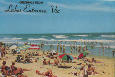
Postcard - Tourism, Rose Stereograph Co, 1960c
Colour postcard of crowd of people many in bathing costumes or sheltered under sun umbrella enjoying sand and surf at Main Beach Lakes Entrance VictoriaGreetings from Lakes Entrance Vic.tourism, waterways, beaches -
 Lakes Entrance Historical Society
Photograph - Red Bluff 2008, Wendy Price, 1/08/2008 12:00:00 AM
This is the after photograph used in the 150 years Lakes Entrance 1858 to 2008 display held in October 2008 paired with image 03731 for displayColour photograph of west side of Red Bluff showing vegetation on the bluff rock and sand at the base situated on ninety mile beach Lake Tyers Victoria waterways, topography -
 Victorian Interpretive Projects Inc.
Photograph - colour, Watering Camels in Egypt, 1916
This card was sent to Australia during World War OneBlack and white photographic postcard of camels watering at wells in the desert in Egypt.Verso: Egypt September 14th 1916 To Mother This is very fine view of Camels watering taken a few hundred yards from our camp & is in what we call a dry salt lake, the top of the sand being damp is quite hard, You will notice a clear patch marked x this is a football ground. You will also notice the heavy sand & camps in the background. Billieworld war one, egypt, camels, salt lake, desert, mmm -
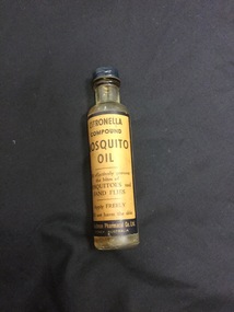 Mont De Lancey
Glass bottle, The Eastman Pharmacal Co. Ltd
Narrow glass bottle containing Citronella Compound Mosquito Oil (approx. 20-25 ml) Has metal screw-on lid and label.On label: "Citronella compound mosquito oil. Will effectively prevent the bites of mosquitoes and sand flies. Apply freely. Will not harm the skin." The Eastman Pharmacal Co. Ltd. Sydney, Australia. bottles, containers, medicine containers -
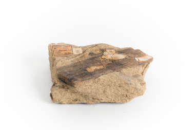 The Beechworth Burke Museum
Geological specimen - Yellow Sandstone
This specimen is from Barefoot Hills, Victoria. Sandstones are economically important as major reservoirs for both petroleum and water, as building materials, and as valuable sources of metallic ores. Most significantly, they are the single most useful sedimentary rock type for deciphering Earth history. This specimen is part of a larger collection of geological and mineral specimens collected from around Australia (and some parts of the world) and donated to the Burke Museum between 1868-1880. A large percentage of these specimens were collected in Victoria as part of the Geological Survey of Victoria that begun in 1852 (in response to the Gold Rush) to study and map the geology of Victoria. Collecting geological specimens was an important part of mapping and understanding the scientific makeup of the earth. Many of these specimens were sent to research and collecting organisations across Australia, including the Burke Museum, to educate and encourage further study.A sedimentary rock composed mostly of quartz sand. Sandstone is the second most common sedimentary rock after shale. Sandstones consist of sand-sized grains principally quartz, feldspar and rock fragments. The two major classes of sandstone are arenite and wacke. the colour of sandstone varies from grey, yellow, red and white reflecting the variation in mineral content and cement and is gritty to touch (like sandpaper).Geological survey / R.... S 61 / Loc Bareboot Hills / Sheet / 24SE / 94 /burke museum, beechworth, indigo shire, beechworth museum, geological, geological specimen, mineralogy, sandstone, yellow sandstone, victoria, barefoot hills