Showing 1378 items
matching state library victoria
-
 Victorian Aboriginal Corporation for Languages
Periodical, John Barnes, The La Trobe journal, 2001
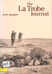
... State Library of Victoria... collection of the State Library of Victoria. Contents: From... Street Brunswick melbourne maps State Library of Victoria maps, b ...The main focus of this edition is the extensive map collection of the State Library of Victoria. Contents: From the Editorial Chair Obituary: Estelle Canning Judith Scurfield The Map Section of the State Library Miles Lewis Maps for Building Research Thomas A. Darragh This Beautiful Work of Art?: Skene and Slight's Continental Australia Gerard Hayes Annotation: Ludwig Becker's ?First Camp from Duroadoo? Susan Ballyn Jean Baptiste Lehimas de Arrieta: The First Spanish Settler in Australia? Frances Thiele Recreating the Polite World: Shipboard Life of Nineteenth-Century Lady Travellers to Australia John Barnes Library Profile: Keith Murdochmaps, b&w illustrationsmaps, state library of victoria -
 Bendigo Historical Society Inc.
Photograph - PETER ELLIS COLLECTION: PHOTOS, 14th January, 1897
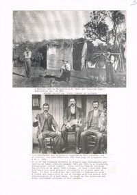
... State Library of Victoria.... Latrobe Collection, State Library of Victoria. The second photo... Library of Victoria Bill Coleman Charles Coleman John Robertson ...Two black and white photos pasted onto a sheet of paper. The top photo is a photo of three men, one playing a fiddle, one with a brass instrument and the third is not very clear. They are in front of a hut with branches on the roof and hessian walls. Beneath the photo is typed on a piece of paper - A Bendigo Camp by Mulgarrie W. A. (Boer War Training Camp? Bendigonian Jan. 14 1897. Latrobe Collection, State Library of Victoria. The second photo is three men, dressed in suits and sitting on chairs in front of a building. One has a clarinet, the middle one has a concertina and the other has a fiddle. The men are the Coleman Brothers. The photo was taken by a travelling photographer called Siebart.photo, group, male, peter ellis collection, mulgarrie w a, boer was training camp?, bendigonian 14/1/1897, latrobe collection, state library of victoria, bill coleman, charles coleman, john robertson, singabout vol 6 no 1 1966, siebart, peter cuffley -
 Darebin Parklands Association
Mulberry Spur, 1974, 1974
... Victoria (Accession No: YMS 13746). Please contact State Library... Victoria (Accession No: YMS 13746). Please contact State Library ...Artichoke thistles were one of the many widespread environmental weeds which had to be eradicated before re-planting the Parklands.B&W photograph. The alluvial tongues of Mulberry Spur with quarry beyond and panorama of Melbourne. Artichoke thistles covering foreground right. This item and all other Darebin Parklands Association archival material is now held by State Library Victoria (Accession No: YMS 13746). Please contact State Library Victoria if access is required. -
 Darebin Parklands Association
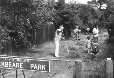
Entrance to Rockbeare Park 15th February 1976, 1976
... Victoria (Accession No: YMS 13746). Please contact State Library... Victoria (Accession No: YMS 13746). Please contact State Library ...B&W photograph of working regular bee. In foreground Shirley Flynn, Secretary of the Darebin Parklands group, the Course children and others. This item and all other Darebin Parklands Association archival material is now held by State Library Victoria (Accession No: YMS 13746). Please contact State Library Victoria if access is required. -
 Greensborough Historical Society
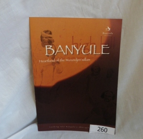
Booklet, Banyule City Council, Banyule: Heartland of the Wurundjeri willam, 2011_
... Collection, State Library of Victoria. Booklet prepared for Banyule... Library of Victoria. 2 copies... are from La Trobe Picture Collection, State Library of Victoria ...This booklet "looks into Banyule's Aboriginal heritage" by detailing some of the history of the Wurundjeri willam clan, including William Barak. Illustrations are from La Trobe Picture Collection, State Library of Victoria. Booklet prepared for Banyule City Council by Phillippa Sutherland.6 pages, colour illustrations. Cover is mainly orange with line drawings courtesy of the Rare Book collection State Library of Victoria. 2 copiesbanyule, wurundjeriwillam, william barak, phillippa sutherland -
 Darebin Parklands Association
Rockbeare Park and Darebin Creek, August 1974, 1974
... Association archival material is now held by State Library Victoria... Victoria (Accession No: YMS 13746). Please contact State Library ...In 1972 Ivanhoe Progress Association planned to fill in the wetlands because they felt it bred mosquitos, and they obtained a grant for this work to take place. Darebin Parklands Association stormed the meeting to get this decision reversed, and the wetlands were never filled in.B&W photograph. Shows wetlands and Darebin Creek. Albion Reid land on fore bank. View from the north with panorama of Kew in the distance This item and all other Darebin Parklands Association archival material is now held by State Library Victoria (Accession No: YMS 13746). Please contact State Library Victoria if access is required. -
 Bendigo Historical Society Inc.
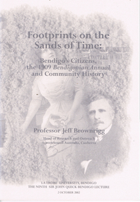
Book - LONG GULLY HISTORY GROUP COLLECTION: FOOTPRINTS ON THE SANDS OF TIME
... State Library of Victoria... The Mirror Henry Gyles Turner Fischer State Library of Victoria ...Book titled Footprints on the Sands of Time: Bendigo's Citizens, the 1909 Bendigonian Annual and Community History with a grey tone cover with images of Sir John Quick, Amy Castles, Amy and Eileen Castles and Anthony Palamountain on the front and back covers. La Trobe University, Bendigo The Ninth Sir John Quick Bendigo Lecture 2 October 2002. Lecture by Professor Jeff Brownrigg, Head of Research and Outreach ScreenSound Australia, Canberra. Mentioned in the book is Sir John Quick, Some women of the early 20th Century, Bendigo's singers and opera singers and why communities all over Australia must face up to the challenges of global media by first recognizing the value of their own stories. Mentioned at the back of the book is a brief mention of Professor Jeff Brownrigg's career, John Quick's career and a list of The Sir John Quick Bendigo Lecture Series from 1994 to 2001.bendigo, history, long gully history group, the long gully history group - footprints on the sands of time, professor jeff brownrigg, research and outreach screensound australia, la trobe university bendigo, sir john quick, bendigonian annual, bendigo school of mines, british empire, alfred deakin, sir william lyne, king o'malley's commonwealth bank, telstra, sir frederick holder, robert garran, john mckay, the mirror, henry gyles turner, fischer, state library of victoria, bishop reville, bendigo evening news, bendigo independent, bendigo advertiser, melbourne university, melbourne age, richard twopenny, mr donald clarke esq, bendigo's butter factory, madame carandini, amy sherwin, nellie melba, oscar commetant, shamrock hotel, constitutional convention adelaide, frederick holder, edmund barton, catherine helen spence, elizabeth nicholls, women's christian temperance union, mary lee, rose scott, susan margery, maybanke anderson, vida goldstein, bendigonian annual, amy castles, alice crawford, edward allan bindley, joseph castles, mercy conent, freeman's journal, catholic press, therese radic melba, state library of victoria, cardinal moran, de quiros, bulletin, john norton, d headon, j brownrigg, lili sharp, eileen castles, mike sutcliffe, melbourne argus, frank cusack, david horsfall, alvin tracey, melbourne's advocate press, amy sherwin, frances saville, lalla miranda, hugo gorlitz, samuels family, louis august samuels, kate (catherina) samuels, madame benda, mathilde marchesi, emily dyason, erna (lovie) mueller, the german chapter, german heritage society bendigo, bertha rossow, hamilton hill, beatrice english, anthony palamountain, alfred bottoms, a c bartlemann, dorothy penfold, dr penfold, penfold gallery, pauline bindley, e a bindley, willie murdoch, sister mary tarcisia, sisters of mercy, peter dawson, bendigo's chinese populatin, masonic hall, ashman's dry-cleaners, walter murdoch, lily baxter, walter savage landor, robert garran, ada colley, australian journal of communication, michelle matthews -
 Darebin Parklands Association
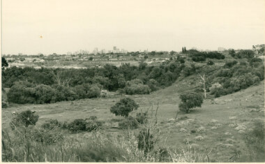
Mulberry Spur with views, 1974, 1974
... held by State Library Victoria (Accession No: YMS 13746... held by State Library Victoria (Accession No: YMS 13746 ...The widespread artichoke weed and other environmental weeds had to be cleared before planting could commence.B&W photograph. Land proposed as Parklands. View of houses in Bennett Street, Alphington and Northcote Hill in the distance. The artichoke weed can be seen across the foreground. This item and all other Darebin Parklands Association archival material is now held by State Library Victoria (Accession No: YMS 13746). Please contact State Library Victoria if access is required. -
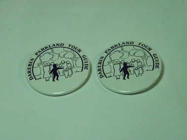 Darebin Parklands Association
Tour Guide Badge, 1978-1998
... archival material is now held by State Library Victoria (Accession... material is now held by State Library Victoria (Accession No: YMS ...The design for the badges was chosen from competition entrants by school children from the nearby area. The badges were worn by volunteer tour guides.Two (2) tour guide badges, B&W, with the writing: Darebin Parklands Tour Guides. Round in shape, made from plastic with metal fastening. This item and all other Darebin Parklands Association archival material is now held by State Library Victoria (Accession No: YMS 13746). Please contact State Library Victoria if access is required.tour guide, badge -
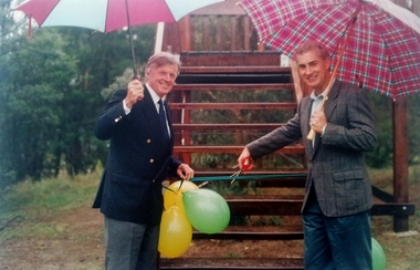 Darebin Parklands Association
Cutting the ribbon of the new viewing deck, Tom Leigh Photographics, 1993-1994
... by State Library Victoria (Accession No: YMS 13746). Please contact... Victoria (Accession No: YMS 13746). Please contact State Library ...The viewing deck was designed by Trevor House, architect.Colour photograph of Councillor Vin Heffernan (left) and Rob Gell, Channel 9 & 7 weatherman (right) cutting the ribbon of the new viewing deck in Darebin Parklands This item and all other Darebin Parklands Association archival material is now held by State Library Victoria (Accession No: YMS 13746). Please contact State Library Victoria if access is required.Annotated with stickers on back. [1994/015541 case admin] -
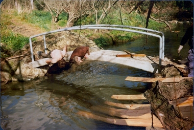 Darebin Parklands Association
Installing Clifton Bridge, 1979-1980
... held by State Library Victoria (Accession No: YMS 13746... held by State Library Victoria (Accession No: YMS 13746 ...The bridge was designed and constucted by Sidney Clifton (pictured), an engineer who lived in a house neighbouring the parklands.Colour photograph. Two men inspecting the underside of the bridge. The remnants of the wooden frame used to set the concrete bridge can be seen on the right hand side. This item and all other Darebin Parklands Association archival material is now held by State Library Victoria (Accession No: YMS 13746). Please contact State Library Victoria if access is required. -
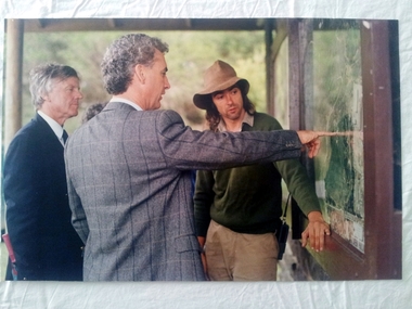 Darebin Parklands Association
Inspecting the board on the occasion of the opening of the viewing deck, Tom Leigh Photographics, 1993-1994
... held by State Library Victoria (Accession No: YMS 13746... is now held by State Library Victoria (Accession No: YMS 13746 ...The viewing deck was designed by Trevor House, architect. Colour photograph of Councillor Vin Heffernan (left), Rob Gell (Channels 9 & 7 weather presenter, centre) and Peter Wiltshire (Darebin Parklands Ranger, right). This item and all other Darebin Parklands Association archival material is now held by State Library Victoria (Accession No: YMS 13746). Please contact State Library Victoria if access is required.Annotated with sticker on back. -
![Article [copy], Memoirs History 1808-1883 / author John Lindsay Beale 1830-1911, 1808-1883](/media/collectors/4f729f5697f83e03086015b8/items/55aa1dc12162f116d4723524/item-media/55aa1e172162f116d4723b03/item-fit-380x285.jpg) Greensborough Historical Society
Greensborough Historical SocietyArticle [copy], Memoirs History 1808-1883 / author John Lindsay Beale 1830-1911, 1808-1883
... on that board. Original manuscript held by State Library of Victoria MS...Manuscript held by State Library of Victoria MS 10553, Call... by State Library of Victoria MS 10553, Call Number MSB 243 john ...Extracts from the "Memoirs History 1808-1883" pages 345-350. This is John Lindsay Beale's account of the formation of the Greensborough Roads Board and Robert William Whatmough's participation on that board. Original manuscript held by State Library of Victoria MS 10553, Call Number MSB 243Copy of 10 typed pages.Manuscript held by State Library of Victoria MS 10553, Call Number MSB 243john lindsay beale, robert whatmough -
 Bendigo Historical Society Inc.
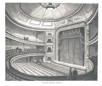
Photograph - WES HARRY COLLECTION: ROYAL PRINCESS THEATRE, 1874\
... Library Victoria.... Library Victoria. Photograph WES HARRY COLLECTION: ROYAL PRINCESS ...Photograph of an Engraving depicting the interior of the Royal Princess Theatre, built in 1874. The engraving copy is from the Australian Sketcher, supplied by the Latrobe State Library Victoria.buildings, commercial, royal princess theatre, royal princess theatre, bendigo theatres -
 Ballarat Tramway Museum
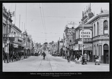
Photograph - Black & White copy photograph, Rose Stereograph Co, "Ballarat looking east along Bridge St from Grenville St c1920s"
... with the original image held by the State Library of Victoria. Edited... by the State Library of Victoria.... by the State Library of Victoria. "Ballarat looking east along Bridge ...Original photograph by Rose Series Postcard P1711 with the original image held by the State Library of Victoria. Edited by Richard Conn. Purchased by the Museum.Provides information about the appearance of Bridge St during the 1920's, shows the tram tracks and overhead. Has in the view a number of road signs, shops, Super Spirit, Shell, Junction Service Station, motor vehicles, cyclists, Bon Marche, ladies with prams, a post box and Page's Bucks Head Hotel.Black & White copy photograph view A4 size, titled "Ballarat looking east along Bridge St from Grenville St c1920s", from a Rose Series Postcard, P1711. Original image held by the State Library of Victoria.ballarat, grenville st, bucks head hotel, bridge st, road signs, bon marche, tramways -
 Darebin Parklands Association
Rockbeare Park 1970s, 1973-1980
... archival material is now held by State Library Victoria (Accession... archival material is now held by State Library Victoria (Accession ...B&W photograph of the area which was to become the Darebin Parklands. Shows tip site and makeshift toilet probably from the days of the former bluestone quarry. Darebin Enterprise Centre is in the distance. This item and all other Darebin Parklands Association archival material is now held by State Library Victoria (Accession No: YMS 13746). Please contact State Library Victoria if access is required. -
 City of Moorabbin Historical Society (Operating the Box Cottage Museum)
Newsletter, City of Moorabbin Historical Society Jun 2010 pdf, June 2010
... state library of victoria... enrolment with 'Volunteering Glen Eira'. State Library of Victoria... eira state library of victoria vicnet dendy henry dendy’s ...The City of Moorabbin Historical Society was formed c 1960 by a group of Moorabbin residents who were concerned that the history of the area should be preserved. A good response to a call for items related to the historical area of Moorabbin Shire brought donations of a wide variety of artefacts which are now preserved by the current members of CMHS at Box Cottage Museum . Helen Stanley, Secretary of CMHS, began producing a Newsletter for members in April 2007 to provide current information and well researched items of historical interest. Helen Stanley has produced a bi-monthly Newsletter, 2007 - 2013, for the members of the City of Moorabbin Historical Society that contains well researched interesting historical items, notification of upcoming events, current advice from Royal Australian Historical Society , Museums Australia Victoria and activities of Local Historical Societies. The Newsletter is an important record of the activities of the CMHS. Photocopied Plan of ‘Two Acre Village c1853’ and notes about the Colonial City Morgue Melbourne c1888 7 x A4 paper printed on 1 side Issue 17 of the bi-monthly, City of Moorabbin Historical Society Newsletter produced by Society member and Secretary, Mrs Helen Stanley in June 2010. Notice of meeting June 17th and recent death of Mrs May Curtis,CMHS member. June 5th , Robina Naughton, CMHS, represented Box Cottage at the 'Fun4over50s' expo at Moorabbin Town Hall. Mr Laurie Lewis donated the 'original water pump' from the first Box Cottage and has provided a list of the commercial properties around Box Cottage c 1900, as he remembers. An application to Glen Eira City Council for a Public Toilet at Box Cottage for visitors and volunteers. A volunteer has joined CMHS following our enrolment with 'Volunteering Glen Eira'. State Library of Victoria has approved CMHS for the 'Vicnet' program where Box Cottage Museum can be promoted. Helen provides a précis, of 4 A4 pages, describing ‘The City Morgue in Colonial Melbourne’ printed in Provenance Journal No3 November 2004.CITY of MOORABBIN HISTORICAL SOCIETY / JUNE 2010 NEWSLETTERcity of moorabbin historical society, stanley helen, curtis may, graham street mckinnon, curtis geoff, moorabbin town hall, lewis laurie, lewis grace, lewis timber pty. ltd., melbourne, moorabbin, brighton, cheltenham, ormond, bentleigh, market gardeners, pioneers, early settlers, moorabbin shire, box cottage museum, water pump, elster creek, volunteering glen eira, state library of victoria, vicnet, dendy henry, dendy’s special survey 1841, mclean n, box henry, joyce park ormond, city of moorabbin, box william, jasper road east brighton, melbourne city morgue, cooke simon, brown mwy andrew -
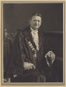 Greensborough Historical Society
Photograph - Digital Image, John Cecil Jessop, 1935_
... Digital copy of photograph. State Library of Victoria... copy of photograph. State Library of Victoria, 49296239 John ...John Cecil Jessop in Mayoral robed. Jessop was Mayor of Heidelberg in 1935.Digital copy of photograph. State Library of Victoria, 49296239 john cecil jessop -
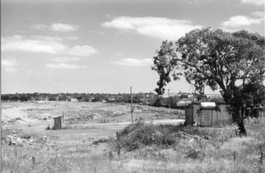 Darebin Parklands Association
Rockbeare Park 1970s, 1973-1980
... archival material is now held by State Library Victoria (Accession... archival material is now held by State Library Victoria (Accession ...B&W photograph of the area which was to become the Darebin Parklands. Shows toilet and other buildings which were probably part of old bluestone quarry operation. The tree at right is still standing (at 2014). The path behind is the extension of Separation Street. This item and all other Darebin Parklands Association archival material is now held by State Library Victoria (Accession No: YMS 13746). Please contact State Library Victoria if access is required. -
![Diary, [Digital file].1840-1841. Charles Griffith](/media/collectors/5e461d8021ea67224c82f2a1/items/67a209aff435c92f9910fa93/item-media/67a20ae0f435c92f9910fc3e/item-fit-380x285.jpg) Bacchus Marsh & District Historical Society
Bacchus Marsh & District Historical SocietyDiary, [Digital file].1840-1841. Charles Griffith
... Digital file. PDF format. Digitised by State Library... Library Victoria from photocopied pages of a hand-written ...Charles Griffith was born in Kildare, Ireland in 1808. He studied at Trinity College, Dublin acquiring a B.A. in 1829 and an M.A. in 1832 before being admitted to practice as barister. In 1840 he emigrated to Australia arriving in the Port Phillip District in November 1840. Soon after arriving he and his friend James Moore formed a business partnership and acquired land in the Parwan Valley near Bacchus Marsh. This land had been in the possession of a Mr. McKenzie who agreed to sell his land and sheep to Griffith and Moore. The property they acquired came to be known as Glenmore. The partnership with James Moore lasted until 1848. In 1846, whilst in Ireland, Griffith married Miss Jane Catherine Magee, then returned to Glenmore and later took his nephew, Molesworth Richard Greene, into partnership, which arrangement proved to be long and prosperous. In 1857, they bought runs at Mount Hope and Mount Pyramid, which they kept until the days of free selection. Griffith led an active and successful public life. He was a member of the new Victorian Legislative Council in 1851, and was later an elected representative of the Legislative Assembly 1853-1859. He occupied many important public positions, including that of magistrate for Bacchus Marsh. Griffith was a devout Anglican and hosted Bishop Charles Perry at his station near Bacchus Marsh in 1849. He died in 1863 at his home in South Yarra. The diary is a detailed account of Griffith's voyage from Ireland to Australia and of his early months in Melbourne. After this it covers his early months establishing himself on his property, Glenmore, near Bacchus Marsh. The timeline of the diary stretches across 1840 and 1841. Griffith was an educated gentleman who made detailed observations about the environment he found himself in. The diary is particularly notable for Griffith's commentary about his interactions with people from first nations, and reveals some of his thinking about Colonial policies directed at first nations people. The diary also includes some sketches of individual first nations people along with some sketches of flora and fauna. The final part of the diary includes a glossary of Aboriginal words Griffith was familiar with. Digital file. PDF format. Digitised by State Library Victoria from photocopied pages of a hand-written transcription of the original diaries written by Charles J. (James) Griffith in 1840 and 1841.charles james griffith 1808-1863, diaries bacchus marsh, glenmore station, wadawurrung people, aboriginal australians bacchus marsh region history -
 Whitehorse Historical Society Inc.
Memorabilia - Correspondence, Cook letters, 1896-1897
... the Maggs. Original letters donated to the Latrobe Library, State... donated to the Latrobe Library, State Library of Victoria..., State Library of Victoria by the Whitehorse Historical Society ...Letters written by William Cook, a Mitcham farmer, from the Western Australian goldfields in 1896-1897.Letters written by William Cook, a Mitcham farmer, from the Western Australian goldfields in 1896-1897. Cook was related to the Till Family by marriage through the Maggs. Original letters donated to the Latrobe Library, State Library of Victoria by the Whitehorse Historical Society.Letters written by William Cook, a Mitcham farmer, from the Western Australian goldfields in 1896-1897. cook, william, goldmining, western australia -
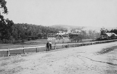 Eltham District Historical Society Inc
Photograph (item), J.H. Clark, View of Eltham from Main Road, c.1907
... Library of Victoria... of an original postcard held by State Library of Victoria View of Eltham ...An F-class 2-4-0 steam locomotive and tender hauls a train of two open wagons, a guards van and a single Tait passenger car over the Eltham Railway Trestle Bridge, heading for Melbourne. This type of steam locomotive was replaced by the F-Class 2-4-2. The house on the right, originally known as 'Derril' was purchased in the early 1920s by Walter Ernest and Alice Miriam Gahan. On the western side of Main Road near the present-day site of Shillinglaw Cottage, they remained till about 1960 when Walter died. The house was demolished in 1968 during the widening of Main Road. In the distance beyond the trestle bridge on what would become Central Park appears to be an orchard of fruit trees. A young man with waist coat, jacket and hat stands beside an older man wearing suspenders without jacket and bare headed, sitting on the post fence. Photographer: J.H. Clark John Henry Clark was the youngest of three boys born to William Henry Clark (1823-1877) and Maria White (1843-1914). He and his brothers, William Charles Clark (1872-1945), Clement Kent Clark (1874-1912) operated a photography business (Clark Bros.) from 25 Thomas Street, Windsor near Prahran during the period c.1894 to 1914. Following death of Clement in September 1912 and their mother in 1914, the Clark Bros business appears to have dissolved, the premises demolished, and a new house was under construction in 1915. John set up business independently in 1914 operating out of 29 Moor Street, Fitzroy where he is registered in the 1914 and 1915 Electoral Rolls. By 1916 John had relocated to Eltham where he continued his practice as a photographer and took many of the early images around the district of Little Eltham. Around 1930 John changed professions and opened a small cobbler's shop in 1931 near the pond opposite Dalton Street adjacent to the Jarrold family cottage. He never married and continued his profession as a bootmaker from this little shop, maintaining a close relationship with Mrs Jarrold for the rest of their lives. His bootmaker shop remains today beside the Whitecloud cottage and is one of only three remaining shops in the area from the early 20th century. There are a couple of images of Eltham taken by Clark Bros. in the Eltham District Historical Society collection, one such example being Hunniford’s Post Office with Miss Anne Hunniford out front (EDHS_00140 - marked on the back of the print, Clark Bros., 25 Thomas St. Windsor), which would date this image between c.1894 and 1914. Other early images of Eltham taken by John Henry Clark are marked on the face “J. H. Clark Photo” and it is assumed these are dated between 1914 and 1930. It is noted that the Grant of Probate for John H Clark of Eltham South dated 5 April !957 (513/387) records his occupation as "X Photographer".derril, eltham railway trestle bridge, f-class 2-4-0 steam locomotive, gahan house, j.h. clark photo, main road, orchards, postcards, steam train, tait train, victorian railways -
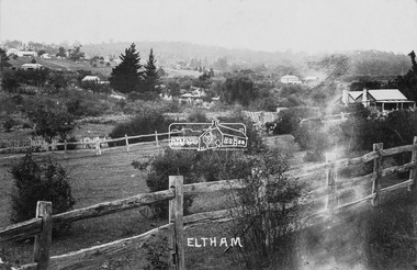 Eltham District Historical Society Inc
Photograph (item), J.H. Clark (poss), View of Eltham across Bridge Street, c.1907
... Library of Victoria... Digital file only of an original postcard held by State Library ...The view is looking southeast from near Eltham Road (present-day Sherbourne Road) across Bolton and Bridge streets towards the village of Little Eltham running down the main road (Maria Street) . On the immediate right is Mrs Mary Jane Smart's family home located on the north side of Bridge Street at the intersection with Bolton Street, facing Bolton Street (now part of present day Brisbane Street and occupied by the Kitchen Design Centre). An original early settler's cottage, it was built by Mary Jane Smart's parents, Edwin Bailey and Jane (nee Matthews). Mary Jane Smart was born in the cottage. She married an Englishman, Alexander Wilson Smart who disappeared to Western Australia in the early 1900s in search of gold. He ultimately married again in W.A., committing bigamy and then committed murder and was hung in 1911. Visible att the top left are Watson's (two-storey) Eltham Hotel at the corner of Pitt Street and Maria Street and the Evelyn Hotel directly opposite. The photo was possibly taken by John Henry Clark of Clark Bros Photographers who operated from 25 Thompson Street, Windsor near Prahan 1894-1914.bridge street, clark bros. photo, early settlers, eltham, evelyn hotel, fountain of friendship hotel, j.h. clark photo, mary jane smart (nee bailey), smart family home, smart home, watsons hotel -
 Greensborough Historical Society
Article - Journal - Excerpt, Victorian Government Gazette, Melbourne water supply 1879, 25/04/1879
... 1 p., photocopy of article, downloaded from State Library...., photocopy of article, downloaded from State Library of Victoria ...An historical account from the Victorian Government Gazette 25/04/1879: Contract accepted - Melbourne Water Supply - B. Barnes & Co. Masonry abutments and piers, also construction and erection of wrought iron aqueduct over Plenty River at Morang. 5250 pounds.History of the Maroondah aqueduct1 p., photocopy of article, downloaded from State Library of Victoriamelbourne water, mmbw, maroondah aqueduct, plenty river -
 Greensborough Historical Society
Article - Journal - Excerpt, Victorian Government Gazette, Melbourne water supply 1890, 15/08/1890
... 1 p., photocopy of article, downloaded from State Library... State Library of Victoria Melbourne water supply 1890 Article ...An historical account from the Victorian Government Gazette 15/08/1890: Contract accepted - Melbourne Water Supply - Mephan Ferguson. Manufacture and erection of wrought iron tubular aqueduct over Plenty River near Greensborough. Addition and extension to Watts River Scheme.History of the Maroondah aqueduct1 p., photocopy of article, downloaded from State Library of Victoriamelbourne water, mmbw, maroondah aqueduct, plenty river, watts river -
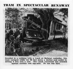 Ballarat Tramway Museum
Photograph - Black & White Photograph/s, The Age, 2/12/1941 or 1/12/1941
... . Made in March 2000 by the State Library of Victoria from a copy... - "Reproduction rights reserved - Copied by State Library of Victoria"... by State Library of Victoria" Black and white photographic ...Yields information about the accident that involved a tram hitting a tree after being derailed and amount of damage done at the time.Black and white photographic reproduction print of a photograph that appeared in The Age Newspaper on 3/12/1941 of an accident involving Ballarat Tram No. 24 running away following a collision in Drummond St. South and hitting a tree at the corner of Dana St. on 2/12/1941. Photograph has the heading and caption. Made in March 2000 by the State Library of Victoria from a copy of the newspaper held in their collection. A similar photograph also appeared in the Courier. The Age copy was in better condition. Hi Res scan added 25/3/2011. See Reg item 5306 for a different photo, but a very good photo, original print - Wal Jack album and gives date as 1-12-1941.On rear of photograph at the bottom is a sticker - "Reproduction rights reserved - Copied by State Library of Victoria"trams, tramways, accidents, ballarat, drummond st, runaway, tram 24 -
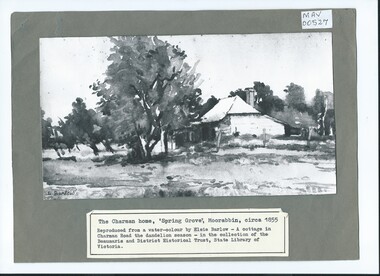 City of Moorabbin Historical Society (Operating the Box Cottage Museum)
Photograph, B/W Watercolour,'Spring Grove' Charman Cottage built c1855 E Barlow c 1900, Elsie Barlow, c1900
... of the Beaumaris and District Historical Trust in the State Library... Library Victoria / Reproduction requires the permission... and District Historical Trust in the State Library of Victoria. 'Spring ...This is a B/W photograph of a Water colour by Elsie Barlow c 1900. The original water-colour is in the collection of the Beaumaris and District Historical Trust in the State Library of Victoria. 'Spring Grove' was the home of the Charman family in the Parish of Moorabbin. Stephen Charman, aged 21years, arrived in Melbourne in 1842 as one of Henry Dendy's Emigrants. 1852 he purchased 160 acres for £328 bounded by Charman Rd and Balcome Rd. 'The Spring' was an important water source for the local Aboriginal people and then for the early settlers. Charman's first wife Harriet and their infant child died and in 1850 he married a widow with 5 children, Mary Gettens. Their first home was made of wattle and daub and they had 7 more children. Later a weatherboard cottage was built c 1855 Together they developed a market garden and specialized in marigolds which were sold for medicinal purposes to the Melbourne Chemists - Martin & Pleasance . The first Methodist Church Services were held at Spring Grove and the Charmans donated land in 1857 for the first Chapel, Cemetery and Primary School . Mary died 1870 and Stephen married again and moved to Gippsland where he died aged 85 in 1906Stephen and Mary Charman were pioneer market gardeners in Moorabbin Shire 1842 and were involved in the development of Church, school and community in the area now called Cheltenham. Charman Road Cheltenham was a boundary of their land. Black & White photograph of a Watercolour of Charman family cottage built 1885 Cheltenham Signed E Barlow on back ; A Cottage in Charman Road - the Dandelion Season / by Elsie Barlow / In the Collection of the State Library Victoria / Reproduction requires the permission of the Library Moorabbin Standard Newspaper moorabbin, cheltenham, dendy henry, dendy's special survey 1841, assisted emigrants early settlers, pioneers, market gardeners, marigold flowers, pharmacy, charman stephen, gettens mary, charman harriet, methodist church, primitive methodists, box william, box elizabeth, state schools, education, moorabbin shire, moorabbin roads board, city of moorabbin, kingston city council -
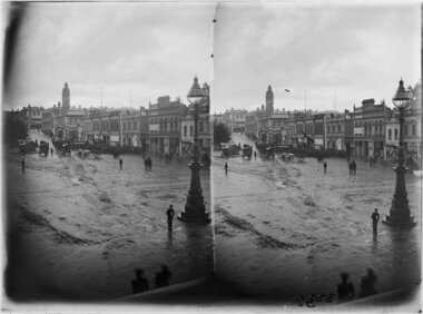 Ballarat Tramway Museum
Photograph - Grenville & Sturt Sts - horse trams looking west, John Henry Harvey, c1900
... Digital image from the State Library of Victoria website... Digital image from the State Library of Victoria website image ...From a series stereo photograph showing the horse tram track from the Bucks Head Hotel at Grenville and Sturt Streets. Shows the muddy nature of the intersection. Has the buildings on the north side of Sturt St in the view. Photograph by John Henry Harvey, c1900.Yields information about the appearance of the intersection of Grenville and Bridge St following the introduction of the horse trams and the terminal arrangements.Digital image from the State Library of Victoria website image No. H86.76/17.trams, tramways, bridge st, grenville st, sturt st, horse trams, stereo photograph -
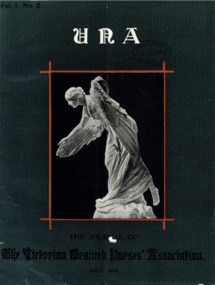 Australian Nursing & Midwifery Federation
Journal, UNA Nursing Journal, 1903
... State Library of Victoria date of acquisition stamps... Library of Victoria date of acquisition stamps UNA Nursing Journal ...UNA, the journal of the Victorian Trained Nurses Association (1903-1974). Media images: UNA Nursing Journal Vol. 74 No. 4 July-August 1976. Members have often asked where the name UNA originated. On this final issue, that question is answered UNA Nursing Journal Vol. 74 No. 2 March-April 1976. RANF (Vic Branch) Specialised Area Nurses - Special Interest Group: four members of the committee at the Burns Study day held at Repatriation General Hospital, Heidelberg on Wednesday 11th February. Left to right: Robyn Millership, Chairman; Judy Aiello, Vice Chairman; Diane Blair; Margaret Farnfield, Hon. Secretary UNA Nursing Journal : Journal of the Royal Victorian College of Nursing Vol. 67 September 1969. Cover picture: Miss Judith Watts is featured on the cover as the graduate of St. Vincent's Maternity Hospital who gained the highest marks in the Midwifery examination in September, 1969 UNA : Journal of the Royal Victorian College of Nursing Vol. 42 No. 9 September 1944. Group of nurses leaving the University after the theoretical examination of the Nurses' Board UNA : The Journal of the Royal Victorian College of Nursing Vol. 38 No. 1 January 1940. Women's Hospital Melbourne UNA : The Journal of the Royal Victorian College of Nursing Vol. 37 No. 12 December 1939. The caravan comes to the Mallee UNA : The Journal of the Royal Victorian Trained Nurses' Association Vol. 18 No. 5 July 1920. Council intelligence; personal; the Alfred Hospital Nurses' League UNA : The Journal of the Royal Victorian Trained Nurses' Association Vol. 11 No. 4 June 1913. List of members UNA : The Journal of the Royal Victorian Trained Nurses' Association Vol. 3 No. 11 January 1906. Hospital news: Queen Victoria Hospital; Women's Hospital; Kyneton Hospital; Maldon Hospital; Maryborough Hospital; Ovens District Hospital; Warrnambool Hospital. Christmas, 1905, amongst a few of the district nurses' patientsnon-fictionUNA, the journal of the Victorian Trained Nurses Association (1903-1974). Media images: UNA Nursing Journal Vol. 74 No. 4 July-August 1976. Members have often asked where the name UNA originated. On this final issue, that question is answered UNA Nursing Journal Vol. 74 No. 2 March-April 1976. RANF (Vic Branch) Specialised Area Nurses - Special Interest Group: four members of the committee at the Burns Study day held at Repatriation General Hospital, Heidelberg on Wednesday 11th February. Left to right: Robyn Millership, Chairman; Judy Aiello, Vice Chairman; Diane Blair; Margaret Farnfield, Hon. Secretary UNA Nursing Journal : Journal of the Royal Victorian College of Nursing Vol. 67 September 1969. Cover picture: Miss Judith Watts is featured on the cover as the graduate of St. Vincent's Maternity Hospital who gained the highest marks in the Midwifery examination in September, 1969 UNA : Journal of the Royal Victorian College of Nursing Vol. 42 No. 9 September 1944. Group of nurses leaving the University after the theoretical examination of the Nurses' Board UNA : The Journal of the Royal Victorian College of Nursing Vol. 38 No. 1 January 1940. Women's Hospital Melbourne UNA : The Journal of the Royal Victorian College of Nursing Vol. 37 No. 12 December 1939. The caravan comes to the Mallee UNA : The Journal of the Royal Victorian Trained Nurses' Association Vol. 18 No. 5 July 1920. Council intelligence; personal; the Alfred Hospital Nurses' League UNA : The Journal of the Royal Victorian Trained Nurses' Association Vol. 11 No. 4 June 1913. List of members UNA : The Journal of the Royal Victorian Trained Nurses' Association Vol. 3 No. 11 January 1906. Hospital news: Queen Victoria Hospital; Women's Hospital; Kyneton Hospital; Maldon Hospital; Maryborough Hospital; Ovens District Hospital; Warrnambool Hospital. Christmas, 1905, amongst a few of the district nurses' patientsnursing history, nursing, nursing education, nursing professional standards, nurses - labour unions - victoria, labour unions, history of nursing, australian trained nurses' association, nursing periodicals, royal victorian college of nursing, royal australian nursing federation, australian nursing federation. victorian branch, anmf, anf, ranf, rvcn, vtna, atna, rvtna -
Lakes Entrance Historical Society
Book, Photographs from SLV
... the collection at the state library of victoria Melbourne... photographs available from the collection at the state library ...Contains information on some photographs available from the collection at the state library of victoria Melbournetownship, photography