Showing 9541 items matching "street names"
-
 Melbourne Tram Museum
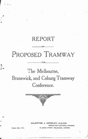
Document - Photocopy, Valentine J. Crowley Consulting Engineer, "Report on Proposed Tramway for The Melbourne, Brunswick and Coburg Tramway Conference", Original 1915
... , overwritten in ball point pen with street names dated Dec. 1919... pen with street names dated Dec. 1919. Photocopy made from ...Photocopy - Report - 12 pages - titled "Report on Proposed Tramway for The Melbourne, Brunswick and Coburg Tramway Conference", prepared by Valentine J. Crowley Consulting Engineer Oct. 25, 1915. Looks at the construction of a tramway Flinders St along Queen St, to Royal Park, to Sussex St and Gaffney Road, West Coburg for the Melbourne Brunswick and Coburg Tramways Trust. Looks at the route and length of track in detail, route, administration, population, construction, permanent way, overhead lines, feeders, rolling stock, timetable, capital cost, alterations to services, expenditure for year and conclusion. Has a map of the proposed route. Included with the document is a plan of the MBCTT lines, overwritten in ball point pen with street names dated Dec. 1919. Photocopy made from original documents - has been stapled along the side in three places.trams, tramways, mbctt, maps, new tramway, west coburg, queen st, royal park -
 Tatura Irrigation & Wartime Camps Museum
Photograph - copy, D. Clark, Tatura People, 1993 copy
... Armadale Street, Northcote. Only names known: Barn Parker, Uncle..., 10 Armadale Street, Northcote. Only names known: Barn Parker ...Original photo by Elsie M. Dicker, photographer, 10 Armadale Street, Northcote. Only names known: Barn Parker, Uncle of Mr Rube Parker.Sepia copy of large group of Tatura people, possibly in Fitzroy gardens c 1930. 2 copies 1 on display.Taturaites Picnicformer tatura residence -
Port Melbourne Historical & Preservation Society
Certificate - Title, Crown allotment 2, section 29, Town of Port Melbourne, Office of Titles, Victoria, Jul 1891
... 29, Town of Port Melbourne, Heath Street. Title in name... of Port Melbourne, Heath Street. Title in name of Melbourne ...Certificate of title relating to Crown allotment 2, Section 29, Town of Port Melbourne, Heath Street. Title in name of Melbourne Permanent Building Society. registered 29th July 1891. title UDL 957, Folio 191304local government - town of port melbourne, town planning, land sales -
 St Kilda Historical Society
Photograph, Donald McDonald, Herford, 1872
... named 'Hertford Street' very close to this location. ..., there is now a street named 'Hertford Street' very close ...Large residence on large elevated block for Frederick Christian Lange (1832-1888) and family in 1870. The architect Lloyd Tayler (1830-1900) designed it in an Italianate style. Over time adjoining allotments were purchased until the gardens covered nearly 15 acres. Lange was in partnership with Emil Thoneman trading under the name of Lange & Thoneman, merchants and general importers. Lange was also one of the local directors of the local Australasian directors for the Swiss Lloyd Marine Insurance Company. William Officer (1835-1913), pastoralist, bought the property from Lange in 1888 for 23,500 pounds. Following Officer's death the grounds were subdivided in 1914 and the house finally demolished in 1940. Noting the spelling difference, there is now a street named 'Hertford Street' very close to this location. black and white photograph copyAlma Road south west corner Lansdowne Road built for Federick C Lange (Merchant) Photo 1872 -
 Bendigo Historical Society Inc.
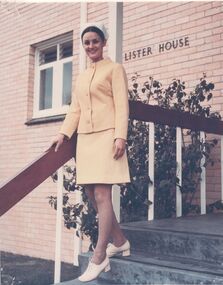
Photograph - Student uniform Lister House
... on the steps of Lister House, Rowan Street, Bendigo. Colour photograph... Inc. History House 11 Mackenzie Street Bendigo goldfields NDSN ...Student, Pauline Crawford (nee Harries), in student uniform on the steps of Lister House, Rowan Street, Bendigo. Colour photograph Name cannot be found in student registers.Pauline Crawford (nee Harries), good pose, uniform satisfactory, toilet block (windows) obstructs view, steps for base 8594.8andsn, nursing -
 Bendigo Historical Society Inc.
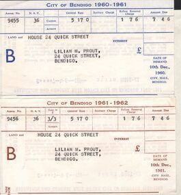
Document - L. PROUT COLLECTION: CITY OF BENDIGO RATE NOTICES
... Street in the name of Lilian M. Prout. The amount due on both.... Land and house at 24 Quick Street in the name of Lilian M ...Two city of Bendigo Rate Notices. The first is for 1960-1961 and the second for 1961-1962. Land and house at 24 Quick Street in the name of Lilian M. Prout. The amount due on both is 7 pounds, 4 shillings and 6 pence.organization, government, city of bendigo -
 Bacchus Marsh & District Historical Society
Map, Atkins and Clarke Land Sale situate at Bacchus Marsh 1856 Copy 2
... indicate the name Crook Street on the map. As the Crook family were... indicate the name Crook Street on the map. As the Crook family were ...This plan of land allotments for sale indicates the property once owned by the Bacchus family in and around the township area of Bacchus Marsh. The Bacchus family sold their property in Bacchus Marsh to John Atkins and Robert Nalder Clarke in March 1851. Atkins and Clarke kept the property for a number of years until April 1856 when these allotments were put up for sale.This plan is almost identical to another copy held by the Bacchus Marsh and District Historical Society, VC Record 707, BMDHS collection). This plan, VC Record 452 Copy 2, contains a less detail than than VC Record 707 Copy 1. For example the selling agents and the surveyor who created the plan are not indicated on this copy of the plan. This copy of the plan does indicate the name Crook Street on the map. As the Crook family were the buyers of the Manor House property and surrounding land from Atkins and Clarke in 1856 it suggests that this copy is a later one of the earlier version. It is unlikely that the Crook family would have had the adjacent street named after them prior to purchasing the house and property. This is a very early land sales plan for the township of Bacchus Marsh and it therefore provides some clues as to how the early urban development of the township took place. Upon seeing the map in 1911 Bacchus Marsh Express newspaper editor Christopher Crisp wrote "The sale appears to have created the present township, which had a nucleus in earlier times further east", Express, 30 September, 1911, page 3. A single page paper map showing a portions of land available for sale in Bacchus Marsh in 1856. The subdivided land shown was owned by John Atkins and Robert Nalder Clarke, but previously owned by the Bacchus Family and was in and around their Manor House (Mansion) property in Bacchus Marsh.There are 5 portions of land further divided into numerous small portions. The land for sale is bounded by the present day streets of Main Street, Young Street, McFarland Street, Morton Streets, Crook Street, and part of the eastern section extends to the Lerderderg River. Scale: 4 chains to 1 inch. The map is pasted into a bound volume containing 76 maps or plans in total. High resolution digital image stored on BMDHS computer network. Plan of the first portion of land. The property of Messers Atkins and Clarke situate at Bacchus Marsh.land sales, land sales bacchus marsh, manor house bacchus marsh, crook family bacchus marsh -
Kew Historical Society Inc
Archive (Sub-series) - Subject File, DERRICK family, 1958
... Street is named after them. The Derrick archive file includes... family were early settlers in Kew. Derrick Street is named after ...Various partiesReference, Research, InformationSecondary Values (KHS Imposed Order)The Derrick family were early settlers in Kew. Derrick Street is named after them. The Derrick file includes minutes of meetings at which Derrick family descendants attended, correspondence, research notes on the Derrick Family, maps of the Derrick landholding in Kew (and a photocopy of the Certificate of Title), and photocopy of a letter from John Derrick to Francis Barnard (original in archive). There are also sundry newspaper articles/clippings.derrick family, kew -- history -- pioneersderrick family, kew -- history -- pioneers -
Whitehorse Historical Society Inc.
Article, Painful memories linger on
... in the war, and after whom some Mitcham streets have been named... Young Joseph Leopold Alwyn Street Mitcham Owen Street Mitcham ...Anzac Day feature on Raleigh Armstrong, returned World War 2 serviceman and on five Mitcham servicemen who died in the war, and after whom some Mitcham streets have been named, [note: errors in the article corrected] by Salena Brunsdenarmstrong, raleigh edward, till, alwyn, loftus, owen spencer, bremner, william ross, peake, ronald mosely, vasey, george, young, joseph leopold, alwyn street, mitcham, owen street, mitcham, ross street, mitcham, ronald street, mitcham, vasey grove, mitcham, young street, mitcham, mcphee, peter -
 Eltham District Historical Society Inc
Photograph, Kenneth Ingram (jnr) and Pam Ingram by the houses at the end of Thomas Street, Eltham, c.1945
... to Margaret Rose Ingram. Thmas Street was named after... to Margaret Rose Ingram. Thmas Street was named after ...Photo taken at the family home of 19 Thomas Street (since replaced by a new build). In the background is 22 Thomas Street, the home of Violet Feldbar (nee Teagle), Pam and Ken's aunt, sister to Margaret Rose Ingram. Thmas Street was named after their grandfather, Thomas Teagle and many of the Teagle family homes were in this street.pamela lorraine ingram, pamela thoonen (nee ingram), eltham, house, margaret rose fielding (nee teagle), thomas street, violet feldbauer (nee teagle), kenneth albert ingram, pam thoonen (nee ingram) collection -
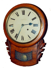 Federation University Historical Collection
Decorative object - Horology, Wall Clock by William Bennett of Ballarat, c1880
... Street, Ballarat, under his name.... The clock would have been sold by William Bennett of Bridge Street ...The clock would have been sold by William Bennett of Bridge Street, Ballarat, under his name.Timber drop case wall clock. The movement it by Ansonia Clock Company of New York United States of America, and the case is most probably of European origin.william bennett, clocks, horology, ansonia, watchmaker -
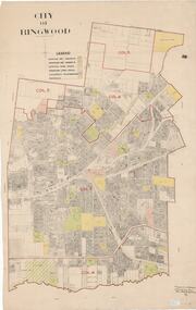 Ringwood and District Historical Society
Map, City of Ringwood - Rateable Properties Layout - c.1966. Overlay showing Reserves, Open Space, Playgrounds, and Schools
... A0-size (approx) map of named streets, lot-numbered... to demolition 1971. A0-size (approx) map of named streets, lot-numbered ...A0-size (approx) map of named streets, lot-numbered properties and locality features within City of Ringwood boundary. Colour-coded legend identifying Existing Rec Reserves, Proposed Rec Reserves, Existing Open Space, Children's Playgrounds, and Schools.Scale: 8 chains to 1 inch. Map picked up in Engineer's office at old town hall prior to demolition 1971. -
Tatura Irrigation & Wartime Camps Museum
Photograph - original, Thomas Hogan Grave
... Forster, his great-grand daughter. Hogan Street Tatura is named...Tatura Irrigation & Wartime Camps Museum 49 Hogan Street ...Original photograph of grave of Thomas Hogan and family, presented to Tatura and District Historical Society by Judith Forster, his great-grand daughter. Hogan Street Tatura is named after him.Original. Old sepia photograph of grave of Thomas Hogan and family, Tatura.on back: grave of Thomas Hogan and family, Tatura Cemetery.thomas hogan, tatura cemetery -
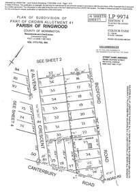 Ringwood and District Historical Society
Document - Subdivision Plan, LP9974 Part of Crown Allotment 41, Parish of Ringwood, County of Mornington Vol 1773 Fol 464 - 1924
... . Additional markings include RP454. Street name amended from Leonard.... Additional markings include RP454. Street name amended from Leonard ...LANDATA Land Victoria 4-sheet plan printout dated 2009Sheet 1 includes Alvena Crescent, Bedford Road and Canterbury Road, Heathmont. Additional markings include RP16869. Sheet 2 includes Alvena Crescent and Bedford Road, Heathmont. Additional markings include PS318390 and CP161633. Sheet 3 includes Bedford Road, Alvena Crescent and Royal Avenue, Heathmont. Additional markings include RP454. Street name amended from Leonard Street to Royal Avenue Vide Gaz 1962 P.427. Sheet 4 includes Alvena Crescent, Royal Avenue, Coleman Street and Canterbury Road, Heathmont. Additional markings include SP27861, PS305057, RP10566, SP34722 and LP116573. -
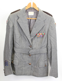 Warrnambool RSL Sub Branch
Service Jacket; Army Nurses Uniform, Early 1940's
... .RAVENSDALE & SON Nicholas Bldg Swanston Street Melbourne". Name... .RAVENSDALE & SON Nicholas Bldg Swanston Street Melbourne". Name ...This uniform was worn by Sister Winifred Ride during World War 2.. Nurses played a key role in the conflict through their care and compassion to the servicemen who were wounded and sick.The nurses uniform is symbolic of the sacrifice and service of the many women who served their country in WW2. Grey fitted, lined jacket with long sleeves, collar and lapels. Three front metal buttons buttons and two smaller buttons on each sleeve. Dark green epaulette with four metal buttons on each shoulder (Right side is faded). Two hip pockets with one button fastener. One internal pocket with small grey button. Unit patches on each sleeve and four inverted service chevrons on right sleeve at wrist. Two ribbon bars containing 5 Campaign Ribbons on left side of front, attached with standard 'brooch' fitting . Belt (same material as jacket) passes through two loops on back of jacket and is fastened by two buttons, hidden when belt is fastened. Metal buttons stamped with map of Australia with crown above and the words Australian Military Forces around. Makers label inside back below collar: " /tailors and habit makers, J .RAVENSDALE & SON Nicholas Bldg Swanston Street Melbourne". Name of owner handwritten "Sister Ride:" -
 Phillip Island and District Historical Society Inc.
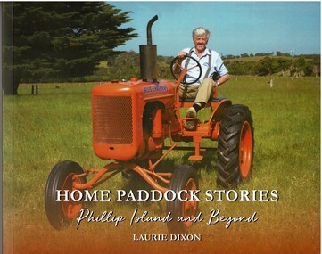
Book, Home Paddock Stories Phillip Island and Beyond, 2023
... street is named, twenty minutes before his twin brother John. His... street is named, twenty minutes before his twin brother John. His ...Laurie is a member of local pioneer family. He was born in 1938, in the hospital gifted to the island community by his grandparents William and Lucy Thompson, after whom the Cowes main street is named, twenty minutes before his twin brother John. His stories providing a unique insight into Phillip Island's social history and development. [ The Advertiser Dec 2023]HistoricalColoured front and back on book - front with Laurie Dixon on his tractor and back cover photo of Laurie with his three dogs. Details of Laurie's life on Phillip IslandHome Paddock Stories Phillip Island and Beyond by Laurie Dixon - Made in 2023 - printed by Print It Fastphillip island, farming, ventnor, allis chalmers tractor, anne oswin, dixon family, cleeland family, laurie dixon, sport -
 Ringwood and District Historical Society
Document - Research Notes, Richard Carter, Land Subdivisions in Ringwood 1890-1950
... in the Ringwood area, with estate names, streets, number of allotments... subdivisions in the Ringwood area, with estate names, streets, number ...Handwritten table listing main local pre-1950s subdivisions in the Ringwood area, with estate names, streets, number of allotments for sale, and where known, vendor agent, LP (Lodged Plan) title registration number, and auction/sale date, some with sale price.Pg1 RINGWOOD STATION ESTATE LP3070 (Year?) Station Street, William Street (now Kendall Street), Wantirna Road, Station Street Pg1 RINGWOOD TOWNSHIP ESTATE LP5577 (1913) Station Road (now Warrandyte Road), Pratt Street (part now Aird Street), Whitehorse Road Pg2 RINGWOOD ORCHARD ESTATE LP4315 (1914) Brysons Road, Hillcrest Road, Anzac Avenue, Sulva Road Pg3 RINGWOOD RAILWAY ESTATE LP7522 (1918) Whitehorse Road (now Mount Dandenong Road), Dublin Road, Freeman Street, Patterson Street, Bona Street Pg4 THE RINGWOOD ESTATE LP7578 (1919) Warrandyte Road, Hobart Street, Paxton Street, Arnold Street Pg5 GARDEN FARMS ESTATE (LP?) (1919) Canterbury Road, Armstrong Road, Bungalook Road, Orchard Road, Bayswater Road (now Mountain Highway) Pg6 THE RINGWOOD ESTATE (SECOND SUB-DIVISION) LP7604 (1919) Warrandyte Road, Tamar Street, Derwent Street, Mersey Street Pg7 RINGWOOD STATION ESTATE LP7703 (1919) Bedford Road, Williams Grove (now Lena Grove) Pg8 RINGWOOD TOWNSHIP ESTATE LP8198 (1919) Wantirna Road, Ellison Street, Haig Street, Greenwood Avenue Pg9 EASTFIELD ESTATE (LP?) (1920) Eastfield Road, Longview Road, Pleasant Rise, The Mount Pg10 ELECTRIC RAILWAY ESTATE RINGWOOD LP9473 (1922) Campbell Street, Myrtle Avenue, George Street (now Tudor Court), Henry Street (now Myrtle Avenue), Williams Grove (now Lena Grove) Pg11 RINGWOOD PARK ESTATE LP7884 (1922 - two stages) Wonga Road (now Loughnan Road), William Street, Andrew Street, Harrison Street Pg12 HEATHMONT STATION ESTATE LP11009 (Date? - after 1922) Lisgoold Street, Viviani Crescent, Balrour Avenue, Station Street (now part Heathmont Road and part Wainui Street) Pg13 RINGWOOD RAILWAY ESTATE LP10507 (1923) Whitehorse Road, Sherbrooke Avenue, Burwood Avenue, Bonview Avenue, Heatherbrae Avenue, Grant Crescent Pg14 GARDEN HOMES ESTATE (LP?) (1923) Mullum Road, The Centreway, Wattle Crescent (now Wattle Avenue) Reserve Crescent (now Reserve Road) Pg15 DUBLIN ROAD ESTATE LP11993 (1923) Alexandra Road, Vonadawn Avenue, Green Street, Wood Street, Howard Avenue, Bedford Road, Dublin Road Pg16 CARLINGA ESTATE RINGWOOD LP9620 (1923) Bourke Street, Bond Street, Ringwood Street Pg17 PRATT'S JUNCTION ESTATE (LP?) (1923) Junction Street, Georges Road, Oliver Street, Whitehorse Road Pg18 EAST RINGWOOD ESTATE LP10492 (1923) Bona Street, Patterson Street, Miller Grove, Fairview Avenue, Eastfield Road, Whitehorse Road (now Mount Dandenong Road) Pg19 COLEMAN'S HEATHMONT ESTATE LP9974 (1923) Canterbury Road, Bedford Road, Alvena Crescent, Coleman Street, Leonard Street (now Royal Avenue) Pg20 RINGWOOD HEIGHTS ESTATE LP10506 (1924) Whitehorse Road, Bonview Avenue, Grant Crescent, Hillcrest Avenue, Heatherbrae Avenue, Margaret Street, Mary Street Pg21 EAST RINGWOOD STATION ESTATE LP10551 (1924) Knaith Road, Wenwood Street, Lois Street, Victoria Street, Station Street (now Railway Avenue) Pg22 GRAND VIEW ESTATE LP11019 (1924) Whitehorse Road, Rupert Street, Herbert Street, Leonard Street Pg23 RINGWOOD RAILWAY ESTATE & RINGWOOD HEIGHTS ESTATE - FINAL SECTIONS LP10506 & LP10507 (1924) Whitehorse Road, Sherbrooke Avenue, Burwood Avenue, Bonview Avenue, Heatherbrae Avenue, Margaret Street, Mary Street, Grant Crescent Pg24 RINGWOOD EAST ELECTRIC STATION ESTATE (LP?) (1924) Railway Parade (now Patterrson Street), Federal Road, Howship Avenue (part now French Street), Dublin Road, Rosedale Crescent Pg25 BEDFORD PARK (now Ringwood Secondary College) (LP?) (1924) Bedford Road, Adams Street, Anderson Street, Joyce Street, Graham Road Pg26 CROWN JEWEL ESTATE LP11645 (Private sales after 1924) Mount Dandenong Road, Mirabel Avenue, Valda Avenue, Evon Avenue, Velma Grove Pg27 GRAND CENTRAL ESTATE LP10917 (1925) Heathmont Road, Great Ryrie Street, Douglas Street, Garden Street, Bellevue Avenue Pg28 RINGWOOD (unnamed estate - 1926) Nelson Street, Seymour Street, Whitehorse Road Pg29 EAST RINGWOOD RAILWAY STATION ESTATE (YEAR? - 25 shops 60 villas) Railway Avenue, Dublin Road, Lawrence Grove, Stanley Avenue, Knaith Road Pg30 CHARM VIEW ESTATE (LP?) (year? - after 1926) Canterbury Road, Heathmont Road, Dickasons Road, Bennjett Avenue, Orchid Street Pg31 SUNBEAM ESTATE LP12150 (Circa 1925) Govt Road (now Old Lilydale Road), Sunbeam Avenue, Holland Road, Everard Street (now Everard Road) Pg32 FAIRVIEW ESTATE EAST RINGWOOD LP10853 (Circa 1924) Eastfield Road, Patterson Street, Margaret Street (now Short Street) Pg33 EAST RINGWOOD TOWNSHIP ESTATE LP3025 (Circa 1924 - 35 allotments) Mount Dandenong Road, Grey Street, Eastfield Road Pg34 EAST RINGWOOD TOWNSHIP ESTATE LP3025 (Circa 1924 - 49 allotments) and STATE SCHOOL ESTATE (26 allotments) and EAST RINGWOOD STATION ESTATE (14 shop sites) Mount Dandenong Road, Grety Street, Dunn Street, Eastfield Road, King Street, Holland Road, Dublin Road, Patterson Street, Bona Street Pg35 EAST RINGWOOD CENTRAL ESTATE LP17004 (1948) Knaith Road, Shasta Avenue, Talofa Avenue, Russet Road, Dublin Road Pg36 WARE ESTATE LP43360 (1958) Ware Crescent, Davey Drive, Grey Road (now Grey Street), Mount Dandenong Road Pg37 Lot 57 Kendall Street LP3070 (1939) £75.0.0 Pg37 Lot 14 LP7346 (year?) £225 Pg37 Lot 8 WHITE HORSE ESTATE LP14010 (year?) Maroondah Hwy, Seymour Street £98.9.0 Pg37 Lots 4-14 incl. LP10902 (year?) £300 Pg37 Lots 69&70 LP2216 (1939) Bedford Road, Pitt Street £500 Pg37 Lots 60&70 LP2216 (year?) £460 Pg37 MOUNTAIN VIEW ESTATE LP10902 (1936) Lots 1&2, 19-22 Wantirna Road, Daisy Street £50 Pg38 RAILWAY STATION ESTATE RINGWOOD EAST LP7522 (1925) Lots 16 to 19 £250 Pg38 RINGWOOD PARK ESTATE (LP?) (1924) Lot 112 Munro Street £230 Pg38 RINGWOOD TOWNSHIP ESTATE (LP?) (1925) Lot 57 Wantirna Road £850 Pg38 ELECTRIC RAILWAY ESTATE LP9473 (1925) Lot 98 & 99 £180 (30/- foot) Pg38 ELECTRIC RAILWAY ESTATE LP9473 (year?) Lot 100 £233.12.6 incl improvements (£2.12.6 foot) Pg38 Lot 22&23 Bedford Road Heathmont (LP & year?) £675 incl improvements Pg39 Lot 9 Mullum Mullum Road LP8221 (1923) £150 Pg39 Lot 27 Haig Street LP8198 (1925) £825 Pg39 Lot 56 Haig Street cnr Wantirna Road LP8198 (1923) £171 Pg39 Lots 3 & 4 Loughnan Road LP9626 (192?) £147 Pg39 Lots 98 & 99 Myrtle Avenue LP9473 (1925) £180 Pg39 Lots 80 & 81 Myrtle Avenue LP9473 (1929) £150 Pg39 Lot 30 Sherbrooke Avenue LP10507 (1926) £700 incl improvements Pg40 Lot 10 (year?) LP7703 £750 Pg40 Lot 36 (year?) LP7522 £25 Pg40 Lot 38 Pitt Street LP2216 (year?) £350 Pg40 Lot 7 Dublin Road cnr Green Street LP11993 (year?) £300 -
 Bendigo Historical Society Inc.
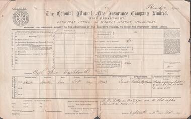
Document - H. A. & S. R. WILKINSON COLLECTION: PROPOSAL FOR INSURANCE
... : butcher shop and dwelling in High Street Eaglehawk. Names... shop and dwelling in High Street Eaglehawk. Names in which ...The Colonial Mutual Fire Insurance Company Limited - Fire Department - Principal Office: 60 Market Street, Melbourne - Bendigo Agency. Proposal for Insurance, subject to the conditions of the company's policies, to which the proponent hereby agrees. Property: butcher shop and dwelling in High Street Eaglehawk. Names in which policy is to be drawn out: J. R. Kelly as mortgagee and Mrs. Philadelphia Schroeder as owners. Contract dated 10th November, 1892 in Eaglehawk.organization, business, h.a. & s.r wilkinson real estate -
 Bendigo Historical Society Inc.
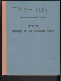
Document - GOLDEN SQUARE LAUREL STREET P.S. COLLECTION: ENROLMENT REGISTER 1919 - 1923
... Primary School, Laurel Street. Register lists names of pupils... Street. Register lists names of pupils, parent names, occupations ...Enrolment register for years 1919 - 1923 for Golden Square Primary School, Laurel Street. Register lists names of pupils, parent names, occupations and addresses. Last school attended, where left to go to. Blue cover, written on front in black ink 1919 - 1923bendigo, education, golden square primary school, bendigo, golden square, laurel street, pupil, school, enrolment -
 Eltham District Historical Society Inc
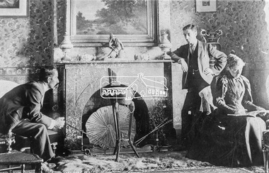
Photograph, Interior of Saxam, Greensborough, 1896. Seated are Mr and Mrs Kaye. Standing is William Stanton
... Mayor of Heidelberg. A Greensborough street is named after him... Mayor of Heidelberg. A Greensborough street is named after him ...Photo from G. Studley reproduced on p80 of The Diamond Valley Story by Dianne H. Edwards, Shire of Diamond Valley 1979. "Interior of Saxam, Greensborough, 1896. Seated are Mr and Mrs Kaye. Standing is William Stanton, local footballer, councillor and later Mayor of Heidelberg. A Greensborough street is named after him. The house still remains and is now in the grounds of Churinga, Diamond Creek Road."Black and white copy of photo printed on glossy photographic paper 30.5 x 40.5 cm (12 x 16 inch); image size approx. 18.5 x 28 cmchuringa, diamond creek road, diamond valley story, fireplace, greensborough, groups, mr kaye, mrs kaye, saxam, william stanton -
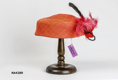 Whitehorse Historical Society Inc.
Headwear - Hat, c. 2000
... Burnett Street, Mitcham. Her name was Roberta, daughter of Mary... Burnett Street, Mitcham. Her name was Roberta, daughter of Mary ...Purchased in Sorrento from shop whose owner grew up at 10 Burnett Street, Mitcham. Her name was Roberta, daughter of Mary and Geoff Eastern, purchased from Harris Scarfe, Forest Hill 1990.Red Pill Box Straw Hat, decorated with red feathers, black beads and crystal beads, with black comb to hold in the hair.Rock Pool Millinerycostume, female headwear -
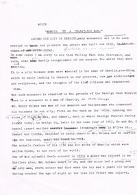 Bendigo Historical Society Inc.
Document - HENRY HOLMES DOCUMENT
... in McCrea Street near Mundy Street. The name Holmes is still... & Samuel Ironmongers where Bendigo Funeral Parlor Bridge Street ...Henry Holmes - one page re HH entitled'' Memoir to a Charitable (sic) Man''. This is an annotated page (draft?) re Henry Holmes - Bendigo pioneer and businessman. Reference to monument to him in the grounds of the Bendigo Base Hospital. Maybe first of a number of pages?? (TD). Clarke, Holmes & Samuel Ironmongers where Bendigo Funeral Parlor is in Bridge Street. A branch shop opened in McCrea Street near Mundy Street. The name Holmes is still on the building.person, individual, henry holmes, henry holmes - one page re hh entitled'' memoir to a charitable (sic) man''. this is an annotated page (draft?) re henry holmes - bendigo pioneer and businessman. reference to monument to him in the grounds of the bendigo base hospital. maybe first of a number of pages?? (td). clarke, holmes & samuel ironmongers where bendigo funeral parlor, bridge street, mccrea street, mundy street, holmes, mr henry holmes, hustlers mine, samual and clarke. -
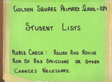 Bendigo Historical Society Inc.
Document - GOLDEN SQUARE LAUREL STREET P.S. COLLECTION: ENROLMENT REGISTER STUDENT LISTS
... Square Primary School, Laurel Street Primary School. Names... Inc. History House 11 Mackenzie Street Bendigo goldfields ...Alphabetical list of names of pupils enrolled at Golden Square Primary School, Laurel Street Primary School. Names are listed roughly in alphabetical order, but not strictly so. The list gives the child's birth date in order of month, date and year. The list was used for the 125th anniversary of the School.bendigo, education, golden square primary school, golden square primary school, enrolment, pupil -
 Bendigo Historical Society Inc.
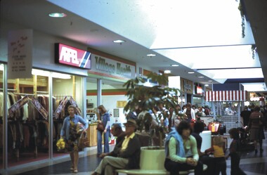
Slide - CHS, MARONG SHOPPING CENTRE, HIGH STREET, KANGAROO FLAT, 1979
... Slide. CHS, Marong Shopping Centre, High Street, Kangaroo... Inc. History House 11 Mackenzie Street Bendigo goldfields ...Slide. CHS, Marong Shopping Centre, High Street, Kangaroo Flat. Re named Lansell Plaza then Centro Lansell. Commonly referred to as Kmart shopping centre. View inside. Date: 7.4.79slide, marong, shopping centre, marong shopping centre, high street, kangaroo flat. re named lansell plaza then centro lansell. commonly referred to as kmart shopping centre. view inside. date: 7.4.79 -
 Bendigo Historical Society Inc.
Slide - CHS, MARONG SHOPPING CENTRE, HIGH STREET, BENDIGO, 1979
... Slide. CHS, Marong Shopping Centre, High Street, Kangaroo... Inc. History House 11 Mackenzie Street Bendigo goldfields ...Slide. CHS, Marong Shopping Centre, High Street, Kangaroo Flat, Bendigo. Name changed to Lasell Plaza then Centro Lansell, commonly referred to as Kmart. Vie inside of centre. Date: 7.4.79slide, marong, marong shopping centre, chs, marong shopping centre, high street, kangaroo flat. lasell plaza, centro lansell kmart -
Clunes Museum
Map, CHARLES FENTON, TRADERS OF FRASER STREET CLUNES
... OF FRASER STREET CLUNES WITH THE NAMES OF TRADERS AT EACH SHOP... WITH STICKY TAPE SHOWING SHOPS OF FRASER STREET CLUNES WITH THE NAMES ...4 X SHETS OF PAPER COMMECTED WITH STICKY TAPE SHOWING SHOPS OF FRASER STREET CLUNES WITH THE NAMES OF TRADERS AT EACH SHOP LOCATION. ALTHOUGH UNDATED IT IS EXPECTED THAT THIS MAP DATES TO APPROX 1870C1870fraser street, traders of clunes -
 Greensborough Historical Society
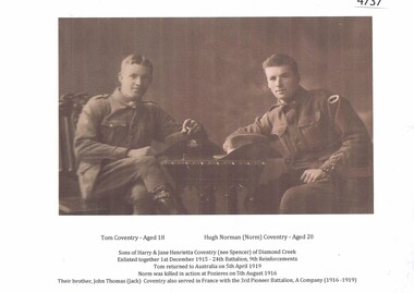
Photograph - Digital image, Tom and Hugh (Norm) Coventry, 1915, 1915_
... . Coventry Street [Montmorency] is named after Tom Coventry, who... December 1915. Coventry Street [Montmorency] is named after Tom ...Photograph of Hugh Norman (Norm) Coventry age 20 and his brother Tom age 18 after their enlistment 1 December 1915. Coventry Street [Montmorency] is named after Tom Coventry, who lived in the area.1page, sepia photograph and notescoventry family -
 Ballarat Tramway Museum
Document, John M Moore, "Investigator" - Geelong Historical Society - Geelong Tramways, 1983
... - issue 54 - March 1979 with an article on Geelong Street names 2... - issue 54 - March 1979 with an article on Geelong Street names 2 ...1 - Investigator Journal of the Geelong Historical Society - issue 54 - March 1979 with an article on Geelong Street names 2 - ditto - issue 71 - with a detailed article on the formation history of Geelong Trams by John M Moore including photos. Establishment of MESCo, J J Jobbins, construction, tracks, buses, practical jokes, map, trams and decorated cars. Also has an article about Geelong Stret names 3 - Scan of issue 72 - Continued from item 2 - route descriptions, 1930s improvement, WW2, tram cars, staff changes, with photos. Report on the closure of the Geelong Tramway System in March 1956, including the presentation of conductor's bells from tram 23 to Cr Camereon and the Mayor of Geelong Cr Fidge. Gives notes on the replacement bus services, events of the last trams and those involved on the day such as Driver Stanley Parker and Conductor Eric Sweetten. See item 9117 for a bell presented to Depot Foremen S Irwin.Yields information about the history of Geelong tramways and its operations.Two copies of the Geelong Historical Society journal "investigator" Nos. 54 and 71 - printed A5 centre stapled and one A4 copy of issue 72 article on Geelong tramways.tramways, state electricity commission of victoria, geelong, tramcars, secv, closure, mesco -
 Ballarat Tramway Museum
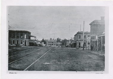
Photograph - Black & White Photograph/s, c1895
... buildings on both sides of the street. Has name J. Nimmon..., looking west, c1895. Shows buildings on both sides of the street ...Black and White copy print contained within the Wal Jack Bendigo and Geelong Album, see Reg Item 5003 for more details. Copy photograph of a photograph from a book (Plate 1) showing a view along High St Eaglehawk, looking west, c1895. Shows buildings on both sides of the street. Has name J. Nimmon? or Ninnis (see btm 4372) in the bottom right hand corner. See also Reg item 5729 for a similar photograph. .1 - On rear in ink "Steam track tracks, Eaglehawk. (So much for the AETA boys who believe steam service did not cross the railway on the level!). In bottom right hand corner is "P. W. Duckett" trams, tramways, bendigo, high st, eaglehawk, steam trams -
Canterbury History Group
Letter - Vaughan Avenue and Flinders Street Reserve, Canterbury, Bennet, Mavis and Potts, Annette, 1/05/1989 12:00:00 AM
... of Vaughan Avenue and Flinders Street Canterbury be named Shrublands... of Vaughan Avenue and Flinders Street Canterbury be named Shrublands ...Copy of correspondence to John Niemann Manager, Urban Design, City of Camberwell requesting the creek at the end of Vaughan Avenue and Flinders Street Canterbury be named Shrublands Creek Reserve, and the letter in reply from the City of Camberwell agreeing to the request.A 4 3 pagescanterbury, vaughan avenue, flinders street, city of camberwell, shrublands creek reserve, creeks, potts> annette, bennett> mavis