Showing 28529 items
matching street street
-
 Port Fairy Historical Society Museum and Archives
Photograph
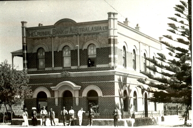
... cox street...Corner of Sackville Street and Cox Street, Port Fairy... Street Port Fairy great-ocean-road Colonial Bank (National Bank ...Colonial Bank (National Bank) before render was applied Black and white PhotographJan - 1911 - plus stamp of The National of Australasia Ltd Port Fairy vicshop, commercial, bank, colonial bank, national bank, cox street, sackville street -
 The Beechworth Burke Museum
Photograph - Photographic Print, c1985
... Camp Street...A 1980s photograph taken of the shops on Camp Street from...Corner of Camp Street and Ford Street, Beechworth, Vic...A 1980s photograph taken of the shops on Camp Street from ...A 1980s photograph taken of the shops on Camp Street from the corner of Ford Street in Beechworth. The photograph shows the Camp Street Butcher which was opened by E Spencer in 1940 to supply locals with the primest quality meat at the lowest possible cash prices.This photograph is part of Burke Museum's collection of streetscape images, capturing the historical essence of Beechworth's streets and township. It serves as a significant visual record, offering valuable insights into the architectural and social fabric of the area during a pivotal period in its history.Black and white rectangular photograph, unmounted.Reverse: 2568/ GWYN MIRRORS CHEMIST BEECHWORTH/ F558camp street, ford street, beechworth, streetscape, shops, butcher -
 Eltham District Historical Society Inc
Document - Photocopy, Survey Fleld Notes of Part of Crown Portion 12, Section 4 at Eltham, Parish of Nillumbik, County of Evelyn, 20 May 1911
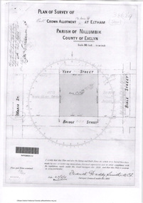
... Bible Street...Portion of land bounded by: Main Road, York Street, Bible... melbourne Portion of land bounded by: Main Road, York Street, Bible ...Portion of land bounded by: Main Road, York Street, Bible Street, Bridge Street Application 38629 Frederick Dudley Smith, M.C.E. Licensed Surveyor, 20 May 1911application 38629, bible street, bridge street, eltham, main road, map, survey plan, york street -
 Hume City Civic Collection
Photograph, late 1980s
... brook street...A coloured photograph of the corner of Brook Street...Hume City Civic Collection 40 Macedon Street Sunbury ...A coloured photograph of the corner of Brook Street and Evans Street, Sunbury, looking towards Macedon Street.post offices, royal hotel, hotels, fire stations, toyworld, businesses, brook street, evans street, sunbury, the corporate personality, george evans collection -
 Canterbury History Group
Document - Plan for the proposed laundry at Canterbury Bowling Club, 1986
... Kendall Street... cnr Kendall Street and Chaucer Street Canterbury... melbourne Canterbury Canterbury Bowling Club Kendall Street Chaucer ...Plans for the proposed laundry at Canterbury Bowling Club cnr Kendall Street and Chaucer Street Canterburycanterbury, canterbury bowling club, kendall street, chaucer street, lawn bowls, plans, laundries -
 Port Fairy Historical Society Museum and Archives
Photograph, 1940's
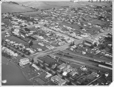
... bank street... on Douglas House across the rail lines showing Bank Street, Sackville... Street Port Fairy great-ocean-road This photograph shows Port ...This photograph shows Port Fairy from the air looking down on Douglas House across the rail lines showing Bank Street, Sackville Street, Cox street and to a lesser extent surrounding streetsThis photograph depicts the Streets and river during the 1940's and the buildings that were present at that time some no longer in existenceBlack and white PhotographALEX WILKINS PHOTOGRAPHER WARRNAMBOOL O.G.Powell Chemist Phone 88 Port Fairybank street, sackville street, railway -
 Port Melbourne Historical & Preservation Society
Photograph - Raglan Street Housing Commission Flats viewed from Crockford Street, Andrew U'REN, C. 1970s - 1980s
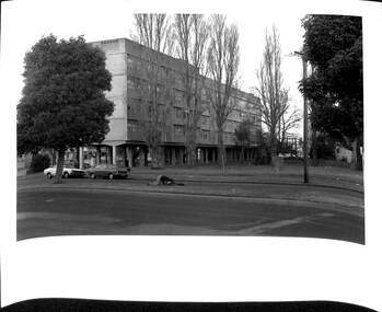
... Raglan Street Housing Commission Flats viewed from...Ingles Street...Black and white photograph of the Raglan Street Housing... Melbourne Town Hall 333 Bay Street Port Melbourne melbourne From ...From a box of photographs in Nancy U'REN's papers used during research for her thesis, The Early Growth and Development of Sandridge (1976) and/or her book with Noel TURNBULL, A History of Port Melbourne (1983). The print was probably made by her son, Andrew U'REN, and he may have also taken the photograph. The photograph includes two people on the median strip. It is unclear what they are doing or what has happened just before the photograph was taken. One person is kneeling closely over the other who appears to be lying on their back.Black and white photograph of the Raglan Street Housing Commission flats at the corner of Ingles and Crockford Streets viewed from Crockford Street. Large white border at the bottom.Details of photographic paper type and exposure details in blue ink on the reverse.built environment - public housing, ingles street, crockford street, raglan street housing commission of victoria flats, built environment - domestic, nancy u'ren nee morris -
 Kew Historical Society Inc
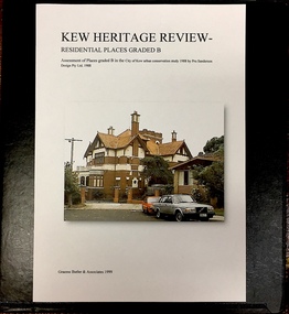
Archive (Sub-series) - Subject File, Kew Heritage Review, Residential Places Graded B, Volume 1, 1999, 1999
... 20 yarra street.... graeme butler, heritage reviews - kew 20 yarra street 8 yarra ...Graeme Butler & AssociatesProject FilesProvenance OrderBlack 4-Ring binder that includes research about, and an assessment of buildings previously graded B in the City of Kew Urban Conservation Study 1988 by Pru Sanderson Design Pty Ltd. The files were created by the heritage architect Graeme Butler and the paper files include maps, correspondence, title searches, readings, reviews of prior classifications, newspaper and journal articles, directories etc for each property assessed.graeme butler, heritage reviews - kew, 20 yarra street, 8 yarra street, 33 wills street, 25 wellington street, 11 wellington street, 118 walpole street, 84 walpole street, 83 walpole street, 63 walpole street, 52 walpole street, 51 walpole street, 14 vista avenue, 12 tara avenue, 89 studley park road, 75 studley park road, 44 studley park road, 25 studley park road, 13 studley avenue, 21 stoke avenue, 71 stevenson street, 34 stevenson street, 12 stevenson street, 36 stawell street, 11 second avenue, 3 second avenue, 2 second avenue, 34 rowland street, 21 redmond street, 11 redmond street, 16 queen street, 27 princess street, 82 molesworth street, 28 miller grove, 26 miller grove, 24 miller grove, 24 milfay avenue, 8 milfay avenue, 4 merrion grove, 25 mary street, 24 lister avenue, 2 john street, 9 hume street, 7 hume street, 24 howard street, 20 howard street, 19 howard street, 10 howard street, 2 howard street, 26 holroyd street, 12 holroyd street, 73 high street, 69 high street, 35 high street, 6 high street, 53 harp road, 6 gellibrand street, 48 foley street, 9 eglinton street, 25-27 edgecombe street, 21-23 edgecombe street, 5-7 edgecombe street, 23 dunlop avenue, 167 derby street, 8 denmark street, 1 denmark street, 2 daracomb avenue, 2 danielle place, 340 cotham road, 294 cotham road, 241 cotham road, 221-229 cotham road, 208 cotham road, 193 cotham road, 180 cotham road, 171 cotham road, 167 cotham road, 161 cotham road, 135-137 cotham road, 46 clyde street, 4 cameron court, 1291 burke road, 1223 burke road, 1205 burke road, 5 bowen street, 35-37 belford road, 389 barkers road, 387 barkers road, 311 barkers road, 231 barkers road, 83-85 barkers road, 15 adeney avenue, 6 a'beckett streetgraeme butler, heritage reviews - kew, 20 yarra street, 8 yarra street, 33 wills street, 25 wellington street, 11 wellington street, 118 walpole street, 84 walpole street, 83 walpole street, 63 walpole street, 52 walpole street, 51 walpole street, 14 vista avenue, 12 tara avenue, 89 studley park road, 75 studley park road, 44 studley park road, 25 studley park road, 13 studley avenue, 21 stoke avenue, 71 stevenson street, 34 stevenson street, 12 stevenson street, 36 stawell street, 11 second avenue, 3 second avenue, 2 second avenue, 34 rowland street, 21 redmond street, 11 redmond street, 16 queen street, 27 princess street, 82 molesworth street, 28 miller grove, 26 miller grove, 24 miller grove, 24 milfay avenue, 8 milfay avenue, 4 merrion grove, 25 mary street, 24 lister avenue, 2 john street, 9 hume street, 7 hume street, 24 howard street, 20 howard street, 19 howard street, 10 howard street, 2 howard street, 26 holroyd street, 12 holroyd street, 73 high street, 69 high street, 35 high street, 6 high street, 53 harp road, 6 gellibrand street, 48 foley street, 9 eglinton street, 25-27 edgecombe street, 21-23 edgecombe street, 5-7 edgecombe street, 23 dunlop avenue, 167 derby street, 8 denmark street, 1 denmark street, 2 daracomb avenue, 2 danielle place, 340 cotham road, 294 cotham road, 241 cotham road, 221-229 cotham road, 208 cotham road, 193 cotham road, 180 cotham road, 171 cotham road, 167 cotham road, 161 cotham road, 135-137 cotham road, 46 clyde street, 4 cameron court, 1291 burke road, 1223 burke road, 1205 burke road, 5 bowen street, 35-37 belford road, 389 barkers road, 387 barkers road, 311 barkers road, 231 barkers road, 83-85 barkers road, 15 adeney avenue, 6 a'beckett street -
 Greensborough Historical Society
Photograph - Digital Image, Chris Foster, The Changing face of Main Street Greensborough (Main Street Plaques Project), 17/05/2018
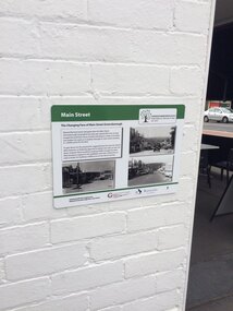
... The Changing face of Main Street Greensborough (Main Street...main street plaques project... in the Main Street area of Greensborough. In these photographs, GHS... Society placed plaques in the Main Street area of Greensborough ...In 2018, Greensborough Historical Society placed plaques in the Main Street area of Greensborough. In these photographs, GHS member Chris Foster, accompanied by GHS President Noel Withers, has photographed the installation of the 'Changing face of Main Street' plaque on Main Street Greensborough. The Main Street Plaques Project placed historical information about original Greensborough buildings as close to the original site as possible. Further information available on the GHS website. The Plaques were made possible through a Greensborough RSL Grant.Digital copy of 3 colour photographs.main street plaques project, main street greensborough -
 Whitehorse Historical Society Inc.
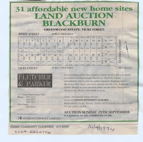
Document, Greenwood Estate, 14/09/1994 12:00:00 AM
... bindy street..., Vicki Street, Vicki Street 'Blackburn' (now Forest Hill), 25... Mitcham melbourne bindy street forest hill vicki street sandra ...subdivision of former Wunderlich site iAdvertisement for auction of 'Greenwood Estate', 31 sites, Vicki Street, Vicki Street 'Blackburn' (now Forest Hill), 25 September 1994. Agent: Fletcher & Parker. In Nunawading Gazettesubdivision of former Wunderlich site ibindy street, forest hill, vicki street, sandra street, greenwood estate, auctions -
 Federation University Historical Collection
Plan, Ballaarat City Parish Plans, 1931, 09/03/1931
... Large Scale plans showing streets, allotments, dimensions... streets, allotments, dimensions, crown grantees, dates granted ...Large Scale plans showing streets, allotments, dimensions, crown grantees, dates granted, etc Sheet 2: Sturt Street, Rubicon Street, Pryor Street, Humffray Street, Sebastopol Street, Armstrong Street South, Fraser Street, Hickman Street ballarat, ballaarat, plans, city of ballarat -
Federation University Historical Collection
Book, Dianne Campbell, Ballarat Rate Book Extracts, c2004
... Lydiard Street...This book idetifies the street locations of Ballarat... Street Armstrong street Doveton Street lyons street errard street ...This book idetifies the street locations of Ballarat lawyers. dianne campbell goldfields lawyers collection, ballarat rate books, lydiard street, armstrong street, doveton street, lyons street, errard street, mair street, webster street, creswick street, drummond street, dana street, eureka street, sturt street, hotham street, hill street, grenville street, urquhart street, ligar street, seymour crescent, eyre street, neil street, dawson street, skipton street, edward a'beckett, thomas a'beckett, augustus abraham, robert adams, david aherne, henry archer, butler aspinall, herbert barrett, john bethune, john bindon, richard birnie, arthur blackwood, john box, frederick brown, charles browning, hugh macdermott, john ogier, robert le poer trench -
Canterbury History Group
Drawing - Illustration, Original house names on original Strathcona property, 1/12/2008 12:00:00 AM
... Scott Street... the area bounded by Scott Street, Bryson Street, Claremont... Street Bryson Street Claremont Crescent Prospect Hill Road ...Illustration prepared by Glen Turnbull of the original house names on the original Strathcona property. This covers the area bounded by Scott Street, Bryson Street, Claremont Crescent and Prospect Hill Road, Canterbury.canterbury, strathcona baptist girls grammar school, scott street, bryson street, claremont crescent, prospect hill road, claremont park estate, "glen allen", "shalimar", "hilary", "sherwood", "marshalton", "elston", "whitefoord", "natrie" -
 Bendigo Historical Society Inc.
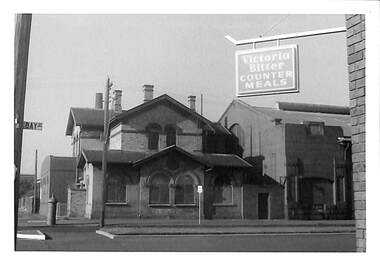
Photograph - EDITH LUNN COLLECTION: BUTTS HOTEL, ON THE CORNER OF WILLIAMSON STREET AND MCLAREN STREET
... WILLIAMSON STREET AND MCLAREN STREET... & McLaren Streets, Bendigo, dated 19/08/1996... Inc. History House 11 Mackenzie Street Bendigo goldfields ...External façade of Butts Hotel on the corner of Williamson & McLaren Streets, Bendigo, dated 19/08/1996Editth Lunn -
Port Melbourne Historical & Preservation Society
Photograph - Old Port Melbourne Post Office, corner Bay Street and Rouse Street, Port Melbourne, Arthur Rowan, 1986
... Old Port Melbourne Post Office, corner Bay Street and Rouse... Streets Est. 1860. First owner Victorian Government... Melbourne Town Hall 333 Bay Street Port Melbourne melbourne ...As a member of the Port Melbourne Historical and Preservation Society, donor Arthur ROWAN photographed a series of significant buildings in the Port and South Melbourne area over several years. A selection of nineteen of these was presented to the Port Melbourne Society in 1993.Small print mounted on white card, with mounted, typed caption: Old Port Melbourne Post Office Corner Bay and Rouse Streets Est. 1860. First owner Victorian Governmentbuilt environment - civic, arthur rowan -
Port Melbourne Historical & Preservation Society
Photograph - Our City, Our Life, Our Choice banner, Crockford Street at Ingles Street, Port Melbourne, Arthur Rowan, 1986
... Our City, Our Life, Our Choice banner, Crockford Street at..., Our Life, Our Choice Banner hung across Crockford Street... Melbourne Town Hall 333 Bay Street Port Melbourne melbourne ...As a member of the Port Melbourne Historical and Preservation Society, donor Arthur Rowan photographed a series of significant buildings in the Port and South Melbourne area over several years. A selection of nineteen of these was presented to the Port Melbourne Society in 1993.Small print mounted on white card, with mounted, typed caption: No amalgamation! for Port Melbourne. Slogan: Our City, Our Life, Our Choice Banner hung across Crockford Street at Ingles St Slogan first prize winner, Joan CURTIS.public action campaigns, arthur rowan, joan curtis -
Port Melbourne Historical & Preservation Society
Plan - Drainage, Board of Works, William Pentland (Coach builders), corner Ingles Street and Crockford Street, 8 Mar 1905
... ), corner Ingles Street and Crockford Street... Melbourne Town Hall 333 Bay Street Port Melbourne melbourne built ...Board of Works drainage plan for William Pentland (Coach builders) at Ingles St and Crockford St corner. 1905built environment - industrial, sue pentland, william pentland -
Port Melbourne Historical & Preservation Society
Plan - Drainage, Board of Works, William Pentland (Coach builders), corner Ingles Street and Crockford Street, 21 Dec 1939
... ), corner Ingles Street and Crockford Street... Melbourne Town Hall 333 Bay Street Port Melbourne melbourne built ...Board of Works drainage plan for William Pentland (coach builders) 1939built environment - industrial, sue pentland, william pentland -
 Port Melbourne Historical & Preservation Society
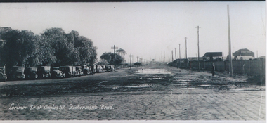
Photograph - Lorimer Street at Ingles Street, Fisherman's Bend, 1930s
... Lorimer Street at Ingles Street, Fisherman's Bend...lorimer street... Melbourne Town Hall 333 Bay Street Port Melbourne melbourne ...Photographic copy of "Lorimer St at Ingles St, Fisherman's Bend" early 1930s. A panoramic photo with added title in white. On left are vehicles parked at the Sandridge Golf Club (formerly the Victoria Golf Club which moved to Cheltenham in 1927)On rear in ink : from "Ginger" Weedon. Formally (sic) from Dunstan Parade Garden City H/C Estatefishermans bend, sport, built environment - domestic, weedon, lorimer street -
 Port Melbourne Historical & Preservation Society
Photograph - Original Post Office, Bay Street, cnr. Rouse Street, Port Melbourne, Janet and Allen Walsh, 1973
... Original Post Office, Bay Street, cnr. Rouse Street, Port...bay street... Post Office (Navy), corner Bay and Rouse Streets... Melbourne Town Hall 333 Bay Street Port Melbourne melbourne Shot ...Shot in 1973 with particular interest in architectureSet of 31 photographs taken in June and July 1973 Original Post Office (Navy), corner Bay and Rouse StreetsIdentified and dated on back in inkbuilt environment - commercial, built environment - domestic, built environment - industrial, janet walsh, allen walsh, bay street, post office -
Port Melbourne Historical & Preservation Society
Photograph - Station Street, near Raglan Street, David Thompson, 1996
... Station Street, near Raglan Street...station street...Colour print, Station Street near Raglan, showing Derwent... Melbourne Town Hall 333 Bay Street Port Melbourne melbourne ...Photographed for Then and Now display, to match 1920 photo (see 586 and 214)Colour print, Station Street near Raglan, showing Derwent House and others, from David Thompson's 1996 'Then and Now 'Series: relates to 214, but also 586parks and gardens, built environment - domestic, david thompson, station street -
Port Melbourne Historical & Preservation Society
Plan - Woodruff Dairies, Bridge Street and Derham Street, Port Melbourne, Norman C Smith, Architects, 6 Oct 1950
... Woodruff Dairies, Bridge Street and Derham Street, Port... Melbourne Town Hall 333 Bay Street Port Melbourne melbourne industry ...From the Woodruff family archives, 4 photocopies 1950 plans for the Woodruff Dairies at Bridge St and Derham St.industry, business and traders - dairies, woodruff's superior dairies -
 Kew Historical Society Inc
Photograph - Looking towards Kew from Strathalbyn Street and High Street, c.1916
... Looking towards Kew from Strathalbyn Street and High Street...An electrified tram route from Melbourne along High Street... High Street, Kew (formerly Bulleen Road). In the centre... An electrified tram route from Melbourne along High Street replaced ...An electrified tram route from Melbourne along High Street replaced an original Horse Tram that terminated at the Kew Cemetery. This new tram only reached the bridge over the Outer Circle railway at the Harp Junction. The line was later extended to North Balwyn.Black and white print positive showing the view west along High Street, Kew (formerly Bulleen Road). In the centre distance is the Boroondara General (Kew) Cemetery. In the foreground, the road crosses the Outer Circle railway. The photograph reflects the level of urbanisation in Kew during the First World War. "Looking towards Kew from Strathalbyn St / High St corner, about 1916. Courtesy Mrs E Bennett, Kew East / Property of Miss Foley"trams -- kew, trams -- kew east, mmtb, m&mtb, tramways, harp junction -
 Kew Historical Society Inc
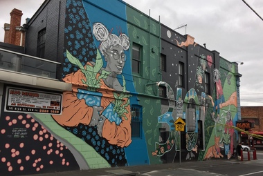
Photograph - Street Art: Brougham Street [Series], 2020
... Street Art: Brougham Street [Series] ...street art -- kew (vic.)... Street... The mural was commissioned and executed in 2020 street art -- kew ...The mural was commissioned and executed in 2020Series of three born digital photos of a mural in Brougham Streetstreet art -- kew (vic.), public art -
 Kew Historical Society Inc
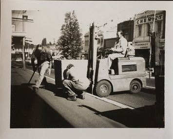
Photograph - Street Beautification: High Street
... Street Beautification: High Street...street beautification... in this instance, street beautification.... Street, Kew. Junction in distance at left...., was responsible for public works, including in this instance, street ...The City Engineer's Department within the former City of Kew, was responsible for public works, including in this instance, street beautification.Kew City Council workers installing planter boxes in High Street, Kew. Junction in distance at left.street beautification, city of kew -- engineers department, public works -- kew (vic.) -
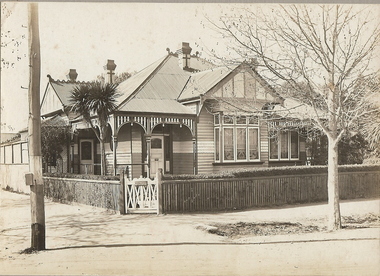 Bendigo Historical Society Inc.
Photograph - T C WATTS & SON COLLECTION: HIGH STREET AND MYRTLE STREET CORNER, 1928
... T C WATTS & SON COLLECTION: HIGH STREET AND MYRTLE STREET... COLLECTION: HIGH STREET AND MYRTLE STREET CORNER ...Gordon Frederick HawleyBlack and white photograph mounted on rectangular grey board. House, two tone weatherboard, triple window on front Return verandah . Front and side entrance. Fretwork trim to verandah. Ornate wooden gate. Picket fence with capping, corrugated iron roof with snailback trim. Small palm front garden. Trimmed hedge.On back of photo: ' Gordon Hawley ( crossed out) High and Myrtle St., £1400 sold' Date stamp 25 August 1928.Frank A. Jeffree Photo Bendigo [White Ink]bendigo, business, t c watts and son, s -
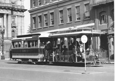 Melbourne Tram Museum
Photograph - Cable tram - Bourke Street at Spring Street, Herald Sun, late 1930s
... Cable tram - Bourke Street at Spring Street... Street at Spring Street Herald Sun ...Photograph shows a cable tram set - trailer number 576 with the destination of Spencer St in Bourke St at the intersection with Spring St. Has Victorian Parliament house in the background. There is a safety zone sign in the foreground for the outbound tram service. Photo late 1930s or 1940Yields information about Bourke St cable trams.Black and White photograph - printed on plain paper.On the rear has the Copyright stamp of the Herald Sun and pencil number "KM-M-006" and Ken Magor stamp.cable trams, bourke st, spring st, parliament house, safety zone -
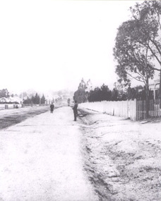 Stawell Historical Society Inc
Photograph, Early Street Scene from Seaby Street Stawell
... Early Street Scene from Seaby Street Stawell...Early Street Scene from Seaby Street... grampians Early Street Scene from Seaby Street Stawell Early Street ...Early Street Scene from Seaby Streetstawell -
 Eltham District Historical Society Inc
Photograph - Aerial Photograph, Intersection of Main Road and Bridge Street, c.1995
... Intersection of Main Road and Bridge Street...Bridge Street...View of Main Road from Henry Street to Brougham Street... melbourne View of Main Road from Henry Street to Brougham Street ...View of Main Road from Henry Street to Brougham Street across to the Diamond Creek showing the Eltham Shire Offices (demolished 1996), the Eltham Library (opened 1994)aerial photo, alistair knox park, bridge street, brougham street, central park, diamond creek (creek), eltham, eltham community centre, eltham courthouse, eltham justice precinct, eltham living and learning, franklin street, henry street, local history centre, main road -
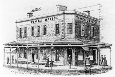 Stawell Historical Society Inc
Drawing, Stawell Times Newspaper Office, corner of Main Street Stawell & Patrick Street in the P.C. News Supplement 1888 -- Sketch
... Stawell Times Newspaper Office, corner of Main Street...Stawell Times Office corner of Main Street and Patrick...Stawell Times Office corner of Main Street and Patrick ...Stawell Times Office corner of Main Street and Patrick Street from Sketch in P.C. News Supplement 1888. Built 1875 for Mrs Nihill as the Club Hotel after the previous building burnt down, Architect Michael Ryan Ararat. Verandah erected 1876. Mortgagee's sale of Club Hotel occurred in 1887. Then Stawell Times Office. Bought by the members of Stawell Sub Branch RSL after WW1 in 1920's as Club Rooms and sold when they mover to Oban Building.stawell businesses