Showing 6913 items matching "the entrance"
-
 Lakes Entrance Historical Society
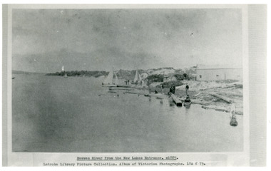
Photograph - Reeves River
Black and white photograph showing building, boats, and workmen at site of proposed New Entrance. View of Reeves River, later called Cunninghame Arm, looking east towards natural entrance. Lakes Entrance VictoriaReeves River from the New Lakes Entrance 1885c waterways, public works -
 Lakes Entrance Historical Society
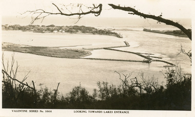
Postcard - Bullock Island
Black and white postcard of west end of Bullock Island, showing rock groynes around island, wooden entrance piers in entrance to Gippsland Lakes from Bass Strait, sand dunes showing New Works houses and sheds. A tree branch across top and foreground shrubbery. Lakes Entrance VictoriaLooking towards Lakes Entrance (on front)islands, waterways, room display -
 Lakes Entrance Historical Society
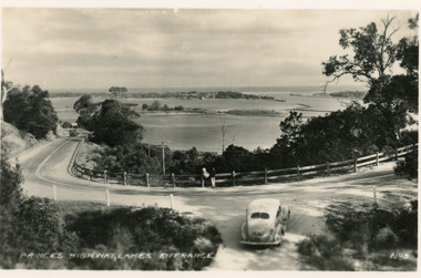
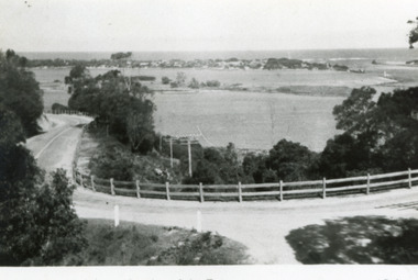
Postcard - Princes Highway Kalimna, Valentine Series, 1930c
Black and white postcard of a bend in the Princes Highway as it winds around Jemmys Point, car parked beside highway, two people leaning on post and rail fence, Bullock Island and Lakes Entrance in the distance. Lakes Entrance VictoriaPrinces Highway Lakes Entrancefences, transport, roads and streets -
 Lakes Entrance Historical Society
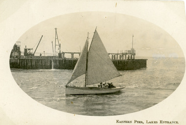
Postcard - Eastern Pier, 1910c
Second copy same imageSepia postcard in cameo image, showing small sailing boat in entrance to the Gippsland Lakes, at Lakes Entrance, Victoria, with wooden eastern pier behind machinery on pier, travelling steam crane on left, 6 - 7 people in boat.Eastern Pier Lakes Entrance waterways, piers, boats and boating -
 Lakes Entrance Historical Society
Postcard - Bullock Island Lakes Entrance, H D Bulmer, 1950 c
Bullock Island and first traffic bridge. Bullock Island has no development. North Arm bridge and Princes Highway in foreground, New Works area across Cunninghame Arm in distance Lakes Entrance Victoria. Also a cut down colour photograph of second humpy bridge to Bullock Island donated by M Fish number 04208.1 size 3 x 13 cm|Also two black and white photographs numbers 04208.2 and 04208.3 in SparesColour tinted postcard of Bullock Island and first traffic bridge. Bullock Island has no development. North Arm bridge and Princes Highway in foreground, New Works area across Cunninghame Arm in distance Lakes Entrance Victoria. Also a cut down colour photograph of second humpy bridge to Bullock Island donated by M Fish number 04208.1 size 3 x 13 cm|Also two black and white photographs numbers 04208.2 and 04208.3 in Spares Bullock Island and Bridge Lakes Entrance waterways, gippsland lakes, islands, vegetation -
 Lakes Entrance Historical Society
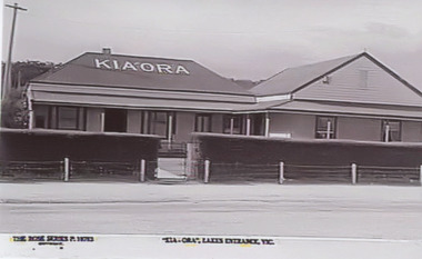
Photograph, The Rose Series, KiaOra guesthouse Esplanade Lakes Entrance Victoria, 1945 c
Black and white photograph of postcard showing KiaOra guesthouse Esplanade Lakes Entrance VictoriaKiaOra Lakes Entrance Vicguesthouses, accommodation -
 Lakes Entrance Historical Society
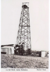
Photograph, Bulmer, Oil rig Lakes Entrance Victoria, 1940 c
Thought to be on the Fosters property c1940Black and white photograph of a postcard showing an oil rig on a property Lakes Entrance VictoriaAn Oil Well Lakes Entrancecivil engineering, oil and gas industry -
 Lakes Entrance Historical Society
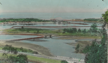
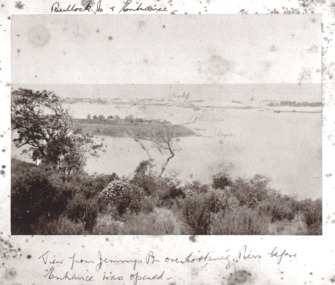
Photograph - Entrance viewed from Jemmys Point, Brooks Photographic Union, 1888 c
Marked on photo Gilders Jetty Flag Staff Red light and groynes on Bullock IslandBlack and white photograph of New Works area prior to opening Lakes Entrance VictoriaBullock Island and Entrance View from Jemmys Point overlooking piers before Entrance was openedwaterways, islands, gippsland lakes -
 Lakes Entrance Historical Society
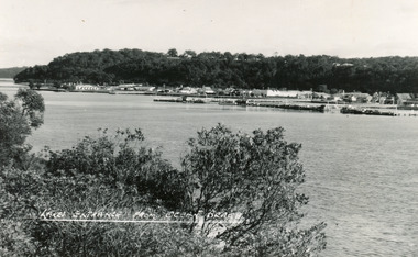
Postcard - Lakes Entrance, Bulmer H D, 1950
Black and white postcard of the township of Lakes Entrance, taken form the south bank of Cunninghame Arm, showing the boat haven, buildings along Esplanade, and the Kalimna escarpment in the distance. Lakes Entrance VictoriaLakes Entrance from Ocean Beachtownship, waterways -
 Lakes Entrance Historical Society
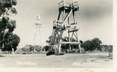
Postcard - Lookout tower Jemmy's Point, Bulmer H D, 1950
Black and white postcard of the timber lookout on Jemmys Point, with the signal light on steel tower nearby. Lakes Entrance Victoria,The Lookout, Lakes Entrancehistoric sites, navigation -
 Lakes Entrance Historical Society
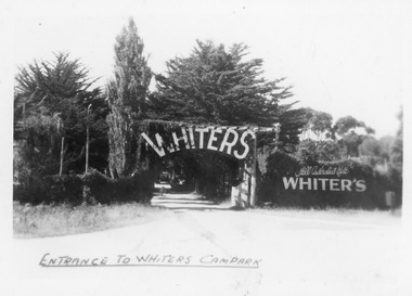
Postcard - Whiters Camp Park, Bulmer H D, 1945c
One of a set of eight small format postcardsBlack and white small format postcard taken from road, showing entrance, treed with signage above double gated driveway at Whiters Camp Park. Sign on fence at eastern side of gateway, Still Australia's Best. Lakes Entrance VictoriaEntrance to Whiters Camp Parkresort, tourism, recreation -
 Lakes Entrance Historical Society
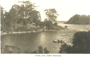
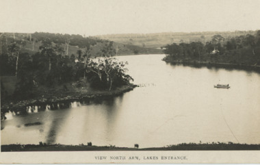
Postcard - North Arm Lakes Entrance Victoria. c1930, 1930 c
04324.1, 9 x 14 cmBlack and white postcard showing two people in a rowing boat on the lower reaches of the North Arm looking downstream Lakes Entrance Victoria c1930. Second black and white postcard of lower reaches of North Arm looking upstream Lakes EntranceNorth Arm Lakes Entrancewaterways, topography, vegetation -
 Lakes Entrance Historical Society
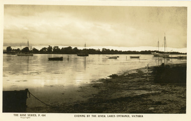
Postcard - Boat Harbour, The Rose Series, 1900c
Black and white postcard of the front lake, showing seven vessels moored in the lake at dusk, small jetty, shore stewn with seagrass. In the background, southern shore of the lake west of the entrance. Lakes Entrance VictoriaEvening by the River, Lakes Entrance Victoriajetties, boats and boating, waterfront -
 Lakes Entrance Historical Society
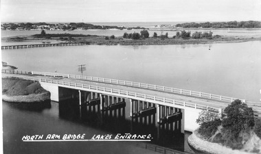
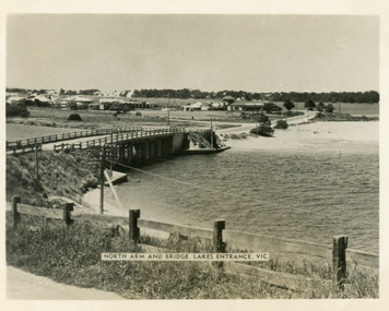
Postcard - North Arm bridge Lakes Entrance Victoria, The Lakes Studio, 1947
Also identical image, good condition, clearer print, collected, also enlargement 16 cm x 25.5 cmBlack and white postcard taken from the path up Kalimna Hill, showing the concrete North Arm bridge; Bullock Island; New Works area and Western side of Entrance. Lakes Entrance VictoriaNorth Arm Bridge Lakes Entrancewaterways, bridges, coast -
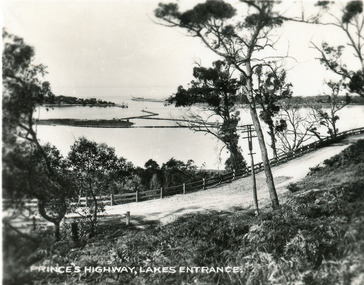
 Lakes Entrance Historical Society
Postcard, Bulmer H D, 1950c
Also one other postcard same donated by M & V Carpenter in spares box.Black and white postcard of the Princes Highway Jemmys Point, showing Bullock Island between North Arm and Cunninghame Arm, distant view of the entrance from Bass Strait to the Gippsland Lakes. Post and rail fence along roadside. Lakes Entrance VictoriaPrinces Highway and a view of the Entrance vegetation, roads and streets -
 Lakes Entrance Historical Society
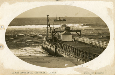
Postcard - Eastern Pier, Vogt, Stanley, 1910c
Oval shaped picture. Also other copies, oval shaped 12.5 x 17.5 cm and 17.5 x 25 cm. Also two black and white prints 9 x 13 cm.Sepia postcard in cameo image, showing early view of eastern pier at the entrance to Gippsland Lakes from ocean - Bass Strait, at Lakes Entrance, Victoria. Photo shows work shed and crane at end of wooden eastern pier, SS Wyralla at sea.Lakes Entrance, Gippsland Lakes machinery, waterways, piers, ships and shipping -
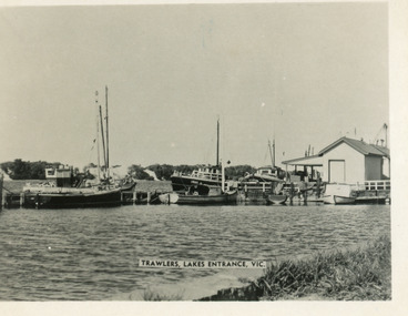 Lakes Entrance Historical Society
Postcard - Trawlers, 1955c
Black and white small format postcard showing trawlers at the eastern wharf. One vessel identified as Irak. Lakes Entrance VictoriaTrawlers Lakes Entrancejetties, boats and boating, waterfront -
 Lakes Entrance Historical Society
Book, Bodsworth, Paul, The Steam Crane, Lakes Entrance, 1998
... The Steam Crane, Lakes Entrance ...Research, interpretation and management recommendations for the Steam Crane remains at the New Works site, Lakes Entrance, East Gippsland, Victoria, by a Forestec studentcivil engineering, transport -
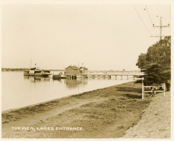 Lakes Entrance Historical Society
Postcard - Western Wharf, Valentine Series, 1930c
Also sepia copy 10x15cm, black and white copies 10x17cm, and 14x24cmSepia coloured small format postcard of the Western wharf, Lakes Entrance, Victoria. It shows the pier variously called the Post Office Jetty, Freemans Jetty, as the steamer leaves. Smaller vessels moored beside jetty. Shoreline edged with bluestone, wooden tree guard surrounding young memorial cypress tree. Lakes Entrance VictoriaThe Pier Lakes Entrancememorials, jetties, waterfront, ships and shipping -
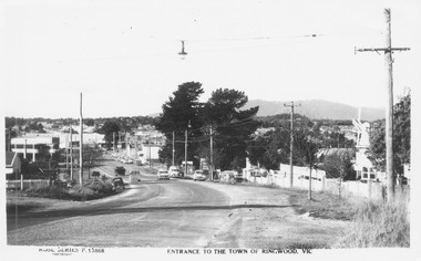 Ringwood and District Historical Society
Postcard, Maroondah Highway West, Ringwood, 1956. Entrance to the town of Ringwood, Vic., looking East - Rose Series Postcard P13868
... Maroondah Highway West, Ringwood, 1956. Entrance to the ...Black and white postcard photograph of Maroondah Highway Ringwood looking east. Note VC Item 4763 is a postal cover imprinted with Windmill Joinery. Inscription on front: "Rose Series P13688 Entrance to the Town of Ringwood, Vic" Hand Written on back of card, "1956 - 'Windmill' joinery on right - Coach and Horses Hotel on left". -
 Lakes Entrance Historical Society
Postcard, 1930c
Also faded copy identical imageBlack and white small format postcard of the Princes Highway at Jemmys Point. It shows the road winding around the hill between the scrub covered hill and the post and rail guard fence, Bullock Island and rock groynes in the lake also entrance in distance. Lakes Entrance VictoriaPrinces Highway, Lakes Entranceislands, fences, roads and streets -
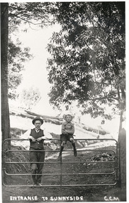 Mt Dandenong & District Historical Society Inc.
Photograph, Entrance To Sunnyside, c1915
J. G. Roberts with his son Bert (sitting on gate) at the entrance to his country home Sunnyside at South Sassafras (now Kallista).Entrance To Sunnyside GGMj g roberts, bert roberts, sunnyside, south sassafras -
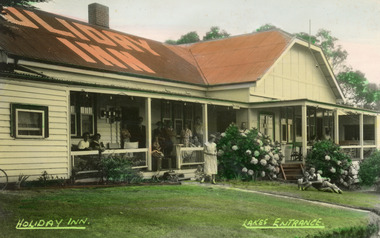 Lakes Entrance Historical Society
Postcard - Holiday Inn, Bulmer H D, 1945
Guesthouse appears to be a conglomerate of disparate additions to its original tea rooms status. Lakes Entrance VictoriaColour tinted postcard of Holiday Inn, showing twelve people on veranders, two adults and child on lawn. Holiday Inn Lakes Entrancehotels, accommodation -
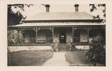 Phillip Island and District Historical Society Inc.
Photograph - Post Card, Early 20th Century
One of a collection of 8 photographs donated by Bob Notley, San RemoBlack & White Postcard of Broadwater Guest House front entrance, Cowes, Phillip IslandNo. 150 Front entrance "Broadwater" Cowesguesthouses cowes phillip island, broadwater guest house, broadwater guest house cowes, bob notley -
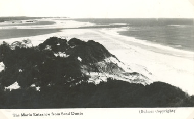 Lakes Entrance Historical Society
Postcard - Sand dunes, H D Bulmer, Marlo Victoria, 1910 c
Black and white postcard of Marlo Entrance taken from sand dunes at Marlo VictoriaThe Marlo Entrance from Sand Dunesjetties, boats and boating, rivers -
 Lakes Entrance Historical Society
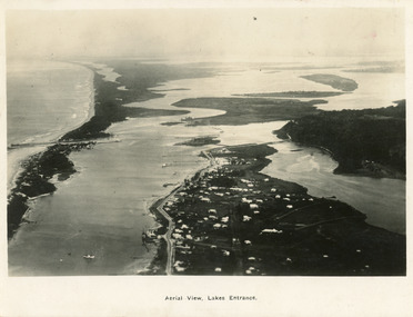
Postcard - Lakes Entrance, 1923c
Also large postcard 15 x 20|Also two mini postcard 6 x 9|Also copy black and white 9 x 14.5Black and white postcard of an aerial view of township of Lakes Entrance, showing western end of town, jetties and boat harbours in Cunninghame Arm, the entrance and piers, North Arm bridge, Bullock Island, Rigby, Fraser and Flannegan Islands, and a distant view of Boole Poole, Bunga Arm and Lake King. Lakes Entrance VictoriaAn aerial view showing position of Lakes Entranceaerial photograph, islands, waterways, topography, township -
 Lakes Entrance Historical Society
Postcard - North Arm Lakes Entrance Victoria. c1935, 1935 c
Black and white postcard showing a tourist launch on the calm waters of North Arm Lakes Entrance Victoria. c1935 Also two other black and white postcards showing launch and rowing boat on North Arm waterway Lakes Entrance View North Arm Lakes Entranceboats and boating, tourism, gippsland lakes -
 Stawell Historical Society Inc
Photograph, Group photograph of four women in Biarri Group outside
Left to Right, Elenor Musumeci, Jill Riddler, Myriam Scott, Unknown Four women outside standing in front of an entrance sign.Entrance in white raised letters on a grey stone block.biarri -
 Lakes Entrance Historical Society
Postcard
Black and white postcard showing Esplanade, cenotaph Lakes Entrance VictoriaView from lookout tower Lakes Entranceroads and streets, township -
 Lakes Entrance Historical Society
Postcard - Lakes Entrance, 1955
The Marine Parade has been formedBlack and white photograph of North Arm bridge Lakes Entrance VictoriaNorth Arm and Bridge Lakes Entrance, Vicwaterways, roads and streets, bridges