Showing 405 items
matching topography
-
 Lakes Entrance Regional Historical Society (operating as Lakes Entrance History Centre & Museum)
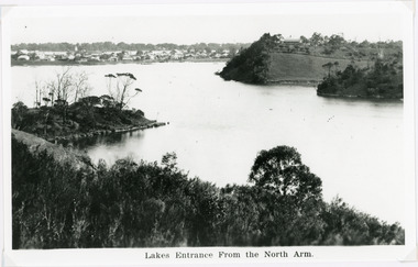
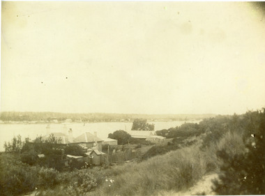
Photograph, 1940c
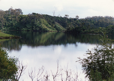
Black and white photograph of the township from the North Arm. It shows the calm waters between steep shorelines covered in natural vegetation and scrub. Lakes Entrance VictoriaLakes Entrance from the North Armvegetation, topography, settlement, waterways -
 Lakes Entrance Regional Historical Society (operating as Lakes Entrance History Centre & Museum)
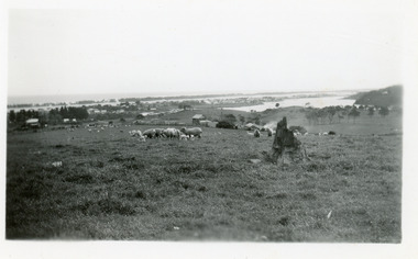
Photograph, Clark, Ruth, 1945c
Also second print 7 x 11.5Black and white photograph of the North Arm and township, taken from Allens Hill, looking across the Butcher's Paddock. It shows the slaughter house, sheep, lambs and other animals in the paddock. Lakes Entrance Victoriawaterways, topography, township, room display -
 Lakes Entrance Regional Historical Society (operating as Lakes Entrance History Centre & Museum)
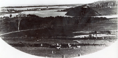
Photograph, 1935c
Enlarged from postcard produced for Mrs Allen to advertise Allens's Tearooms at the brow of Myer St, known as Allen's Hill.Black and white photograph of township, situated between Cunninghame Arm and North Arm. Shows cleared and fenced paddocks on eastern side of North Arm, some clearing and ring barked trees on western side, the high point sometimes referred to as Bernies Point after Bernie Sutherland, who lived and built boats here. Lakes Entrance VictoriaMrs Allens Seaview Cottage Lakes Entrancewaterways, topography, township, room display -
 Lakes Entrance Regional Historical Society (operating as Lakes Entrance History Centre & Museum)
Photograph, 2008
Date made August 2008|This is the paired after photograph used in the 150 year Lakes Entrance 1858 - 2008 display.Colour panoramic photograph of the township, from Allens Hill at top of Myer Street. It shows the town between Cunninghame Arm and North Arm known as Butchers Paddock. Lakes Entrance Victoriajetties, waterways, topography, boats and boating -
 Lakes Entrance Regional Historical Society (operating as Lakes Entrance History Centre & Museum)
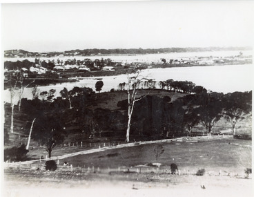
Photograph, 1935c
Enlarged from postcard produced for Mrs Allen to advertise Allen's Tearoom at the brow of Myer St hill, known as Allen's Hill to locals.|This is the paired before photograph showing the left hand side on Butchers paddock in the panoramic views, the right hand side number 01715. This photograph used in the 150 year Lakes Entrance 1858-2008 display.Black and white photograph of the township, taken from Allen's Hill, Myer St. It shows the town between Cunninghame Arm and North Arm, cleared and fenced paddocks in foreground, New Works village and sand hummocks in distance. Lakes Entrance Victoriaboats and boating, township, waterways, topography -
 Lakes Entrance Regional Historical Society (operating as Lakes Entrance History Centre & Museum)
Photograph, Tambo Shire, 1990c
Second copy image identical 20.5 x 28.5Colour photograph of a bay in the North Arm. It shows the calm waters of the lake surrounded by steep wooded banks, a grassy point with remains of fence or jetty. Reflections of surrounding vegetation in water. Lakes Entrance Victoriajetties, retail trade, waterways, topography -
 Lakes Entrance Regional Historical Society (operating as Lakes Entrance History Centre & Museum)
Photograph, Holding M, 2000
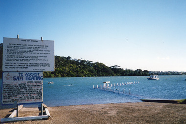
Date made January 2000Colour photograph of high tide in the North Arm. It shows the boat ramp and jetty under water, boat moored in lake, pelican fishing nearby. Warning and instruction signs on shore. Kalimna Heights in background. Lakes Entrance Victoriaboats and boating, vegetation, waterways, topography -
 Lakes Entrance Regional Historical Society (operating as Lakes Entrance History Centre & Museum)
Photograph, 1998
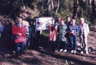
Date made June 1998Colour photograph of a group of people at an interpretative sign at the opening of the Mississippi Creek walking track project at Colquhoun Forest, Lakes Entrance, Victoria.vegetation, waterways, topography, public works -
 Lakes Entrance Regional Historical Society (operating as Lakes Entrance History Centre & Museum)
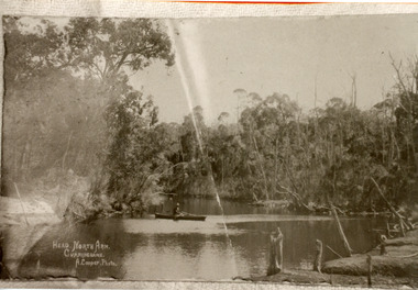
Photograph, Cooper Alexander, 1910c
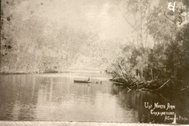
Copied from original by Merle DerbyshireBlack and white photograph of a calm reach of the North Arm. It shows dense vegetation on both sides of the water, person sitting in small boat on lake. Lakes Entrance VictoriaUp North Arm, Cunninghameislands, waterways, topography, public works -
 Lakes Entrance Regional Historical Society (operating as Lakes Entrance History Centre & Museum)
Photograph, Cooper Alexander, 1910c
Copied from original by Merle DerbyshireBlack and white photograph of a section of the North Arm. It shows a person in a small boat on the calm waters, dense natural vegetation on each side of lake. Lakes Entrance VictoriaHead, North Arm, Cunninghamefences, waterways, topography, public works -
 Lakes Entrance Regional Historical Society (operating as Lakes Entrance History Centre & Museum)
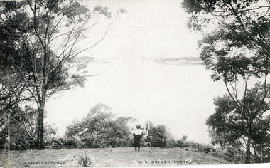
Postcard, Bulmer H D, 1910c
Also black and white enlargement size 16 x 25.| Note on back of postcard, 'Bemm River 16/8/11, To My Dear Elsie, Just a line....., Much love from all, Annie.'Black and white postcard of the man made entrance through the sand hummocks, taken from Jemmys Point. Small boy looking towards entrance, natural vegetation on brow of hill. Lakes Entrance VictoriaLakes Entrancefences, waterways, topography, public works -
 Lakes Entrance Regional Historical Society (operating as Lakes Entrance History Centre & Museum)
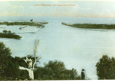
Postcard, 1900c
Also copy tinted postcard 10 x 15Coloured post card of the man made entrance through the sand dunes, taken from Jemmys Point. It shows the works and settlement at the entrance, Bullock Island and groynes to direct flow of lake waters towards entrance. Two men standing on Jemmys Point. Lakes Entrance VictoriaLakes Entrance, Cunninghame, Victoriaislands, waterways, topography, public works -
 Lakes Entrance Regional Historical Society (operating as Lakes Entrance History Centre & Museum)
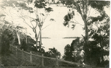
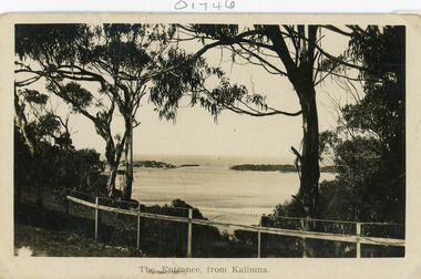
Postcard, Bulmer H D, 1910c
Black and white postcard of the man made entrance through the hummocks, taken from the cliff top at Kalimna. Shows an indistinct distant view of the entrance, natural vegetation in foreground behind simple timber and chicken wire boundary fence. Lakes Entrance VictoriaLakes Entrance from Kalimnawaterways, topography, houses, islands -
 Lakes Entrance Regional Historical Society (operating as Lakes Entrance History Centre & Museum)
Postcard
Black and white postcard of the man made entrance through the sand hummocks, taken from Kalimna cliff top. In the foreground native vegetation on the cliff top behind simple timber and wire netting boundary fence topped with a single strand of barbed wire. Lakes Entrance VictoriaThe Entrance from Kalimnawaterways, topography, houses, islands -
 Lakes Entrance Regional Historical Society (operating as Lakes Entrance History Centre & Museum)
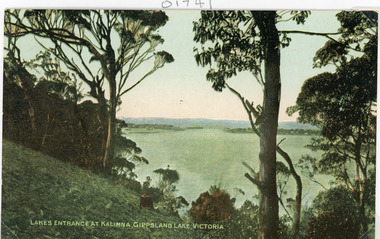
Postcard, 1910c
Colour tinted postcard of the man made entrance to the Gippsland Lakes. It shows the entrance and groynes at Bullock Island, natural vegetation on cliff top in foreground. Lakes Entrance VictoriaLakes Entrance at Kalimna, Gippsland Lakes Victoriavegetation, waterways, topography, public works -
 Lakes Entrance Regional Historical Society (operating as Lakes Entrance History Centre & Museum)
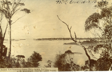
Postcard
Black and white post card showing the man made entrance through the hummock. It shows the fishermen's cottages on the western side of the entrance, Rigby Island and the Doughboy, small island, with salt affected vegetation and a small sand bar in the channel. Natural vegetation of Kalimna cliff in foreground. Lakes Entrance VictoriaLakes Entrance from Kalimna Hotelboats and boating, waterways, topography, public works -
 Lakes Entrance Regional Historical Society (operating as Lakes Entrance History Centre & Museum)
Postcard, 1905c
Message on back of card, to 'Misses M & A Henderson, Swan Reach, Just a line to wish ......, Yours sincerely, R J Gilsenan.'Black and white postcard of the man made entrance. It shows the works building and cottages on each side of the entrance, timber cribs and rock groynes at Bullock Island, natural vegetation of Jemmys Point in foreground. Lakes Entrance VictoriaLakes Entrance, Cunninghamboats and boating, public works, topography, waterways -
 Lakes Entrance Regional Historical Society (operating as Lakes Entrance History Centre & Museum)
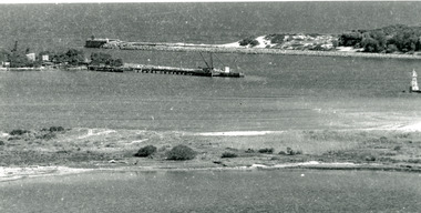
Photograph, 1920c
Copied from photograph in possession of J WhadcoatBlack and white photograph showing stone piers at entrance to Gippsland Lakes from ocean - Bass Strait. Eastern pier on left, dune and western pier on right. Cranes and some work sheds on left. Navigation light on tip of Bullock Island on extreme right. Lakes Entrance Victoriajetties, waterways, topography, township -
 Lakes Entrance Regional Historical Society (operating as Lakes Entrance History Centre & Museum)
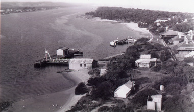
Photograph
Black and white photograph showing aerial view of Works buildings and cottages near man-made entrance toislands, jetties, boats and boating, topography -
 Lakes Entrance Regional Historical Society (operating as Lakes Entrance History Centre & Museum)
Photograph, 1890c
Three copies -Sepia photograph showing dunes, houses and Works buildings and boats at the entrance to Gippsland Lakes from ocean - Bass Strait. Photo shows two PWD houses on left and small school building, plus other Works buildings. Flagstaff on dune above houses. Large barge on left in front of houses. Large passenger steamer at New Works wharf with people waiting, has flags and bunting, two masted ketch on right of rock groynes. Lakes Entrance Victoriajetties, township, boats and boating, topography -
 Lakes Entrance Regional Historical Society (operating as Lakes Entrance History Centre & Museum)
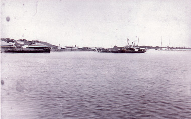
Photograph, 1910c
Also second black and white copy 9 x 13 cmBlack and white photograph showing lakes and boats at new Works Wharf. Some groyne work on Bullock Island on right, road cutting on Jemmys Point on right, Kalimna and Nungurner hills in background. Lakes Entrance VictoriaExcursion Boats, New Works Lakes Entrancejetties, waterways, boats and boating, topography -
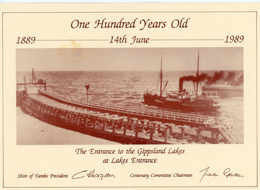 Lakes Entrance Regional Historical Society (operating as Lakes Entrance History Centre & Museum)
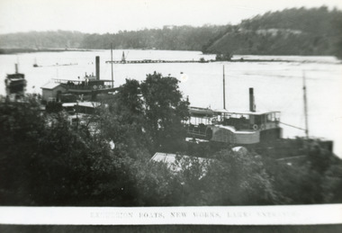
Postcard, 1989
Card printed by Shire of Tambo for the Centenary 14 June 1989, original photo taken 1910cSepia photograph on card advertising 100 years celebration 1889 - 1989 of opening of the Entrance. Photo shows S S Wyralla going out to Bass Strait and the original wooden piers, at Lakes Entrance, Victoria.The Entrance to the Gippsland Lakes at Lakes Entranceboardwalk, schools, township, topography -
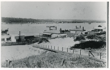
 Lakes Entrance Regional Historical Society (operating as Lakes Entrance History Centre & Museum)
Photograph, 1910c
Also two other black and white copies 9 x 13 cmSepia photograph showing buildings on dunes at New Works. Building on left is works office, centre is school, right is harbour master's home. Steamer at wharf, boardwalk with two men. Lakes Entrance VictoriaLakes Entrance (New Works Jetty)boardwalk, waterways, topography, township -
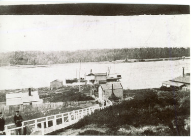
 Lakes Entrance Regional Historical Society (operating as Lakes Entrance History Centre & Museum)
Photograph, 1900c
Also four other black and white copies, one size 12 x 18 cm, two size 9 x 14 cm, and one size 10 x 15 cm, one of which was purchased from Helen ClothierBlack and white photograph showing buildings on dunes, and township of Lakes Entrance across lake, Cunninghame Arm. Buildings from left are school, harbour masters house, harbour engineer's house. Boardwalk in foreground. Kalimna Hill in background. Lakes Entrance Victoriawaterways, vegetation, topography, township -
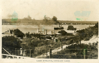 Lakes Entrance Regional Historical Society (operating as Lakes Entrance History Centre & Museum)
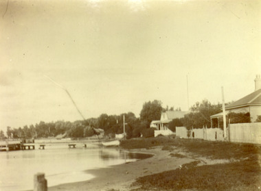
Photograph, 1905c
Also black and white copy 10 x 16.5|Also sepia toned postcard damagedBlack and white photograph showing view from New Works across lake, and Cunninghame Arm. Foreground shows two children on boardwalk, roofs of harbour masters and harbour engineers houses, and the house of the contractor John Carpenter. Smoke billowing from funnel of S S Wyralla. Lakes Entrance Victoriajetties, waterways, township, topography -
 Lakes Entrance Regional Historical Society (operating as Lakes Entrance History Centre & Museum)
Photograph, Phillips, Miss L, 1900c
Also other black and white copy 9 x 14 cm, donated by Russell Goff with inscription The TownSepia photograph showing view from the dunes across lake, and Cunninghame Arm, to township. Foreground shows dense vegetation on dunes behind two houses, harbour engineer's house on left and contractor John Carpenter's house on right. Lakes Entrance Victoriawaterways, township, boats and boating, topography -
 Lakes Entrance Regional Historical Society (operating as Lakes Entrance History Centre & Museum)
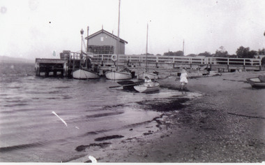
Photograph, Phillips, Miss L, 1900c
Black and white photograph showing New Works jetty with shed on end. Wooden fish boxes stacked at end of shed. Three boats at jetty, two rowing boats at waters edge, two small children, one in boat, one on beach. Lakes Entrance Victoriatopography, houses, fences, waterfront -
 Lakes Entrance Regional Historical Society (operating as Lakes Entrance History Centre & Museum)
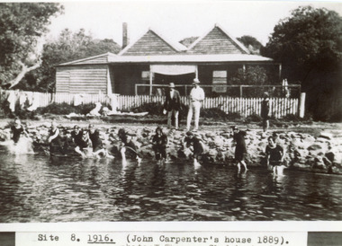
Photograph, Sale, 1916c
Girls in water are in neck to knee swim suitsBlack and white photograph showing twin gable Carpenter House on dunes at New Works. Nine girls at waters edge preparing to swim, and two men and child on rocks. Picket fence across front of house. Lakes Entrance VictoriaSite 8 1916 (John Carpenter's house 1889) photo: W. Thomson, Clydebank, Sale.topography, houses, fences, waterways -
 Lakes Entrance Regional Historical Society (operating as Lakes Entrance History Centre & Museum)
Photograph, Phillips Miss L, 1910c
Two other black and white copies, one 9 x 14 cm, second 11 x 21.5 cmSepia photograph showing houses on dunes at New Works. House on right is harbour engineer's house, next Carpenter house, PWD jetty in front. Lakes Entrance Victoriajetties, houses, boats and boating, topography -
 Lakes Entrance Regional Historical Society (operating as Lakes Entrance History Centre & Museum)
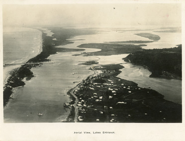
Postcard, 1923c
Also large postcard 15 x 20|Also two mini postcard 6 x 9|Also copy black and white 9 x 14.5Black and white postcard of an aerial view of township of Lakes Entrance, showing western end of town, jetties and boat harbours in Cunninghame Arm, the entrance and piers, North Arm bridge, Bullock Island, Rigby, Fraser and Flannegan Islands, and a distant view of Boole Poole, Bunga Arm and Lake King. Lakes Entrance VictoriaAn aerial view showing position of Lakes Entranceaerial photograph, islands, waterways, topography