Showing 619 items
matching tower house
-
 Bendigo Historical Society Inc.
Newspaper - JENNY FOLEY COLLECTION: BENDIGO FIRE BRIGADE
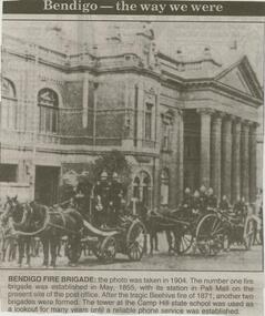
Bendigo Advertiser ''The way we were'' from 2000. Bendigo fire brigade: the photo was taken in 1904. The number one fire brigade was established in May, 1855, with its station in Pall Mall on the present site of the post office. After the tragic Beehive fire of 1871, another two brigades were formed. The tower at the Camp Hill state school was used as a lookout for many years until a reliable phone service was established. The clip is in a folder.newspaper, bendigo advertiser, the way we were -
 Bendigo Historical Society Inc.
Newspaper - JENNY FOLEY COLLECTION: TALL ORDER
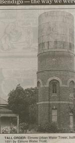
Bendigo Advertiser ''The way we were'' from 2000. Tall order: Elmore urban water tower, built 1891 by Elmore Water Trust. The clip is in a folder.newspaper, bendigo advertiser, the way we were -
 Bendigo Historical Society Inc.
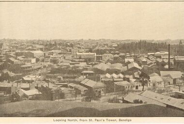
Newspaper - JENNY FOLEY COLLECTION: PICTURESQUE
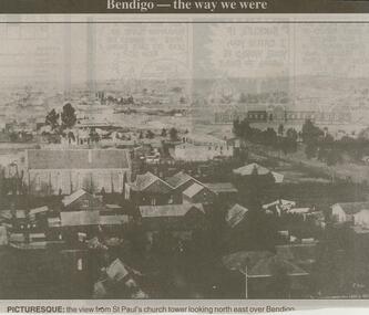
Bendigo Advertiser ''The way we were'' from 2000. Picturesque: the view from St'Paul's church tower looking north east over Bendigo. The clip is in a folder.newspaper, bendigo advertiser, the way we were -
 Bendigo Historical Society Inc.
Newspaper - JENNY FOLEY COLLECTION: PANORAMA
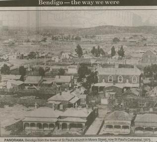
Bendigo Advertiser ''The way we were'' from 2000. Panorama: Bendigo from the tower of St. Paul's church in Myers Street, now St.Paul's Cathedral, 1875. The clip is in a folder.newspaper, bendigo advertiser, the way we were -
 Bendigo Historical Society Inc.
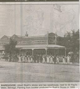
Newspaper - JENNY FOLEY COLLECTION: WAREHOUSE, 2000
Bendigo Advertiser clipping ''The way we were'' from 2000. Warehouse: Albert Bush' s warehouse next to St Paul's tower. Painting from booklet produced by Bush's Stores 1909. The clip is in a folder.newspaper, bendigo advertiser, the way we were -
 Bendigo Historical Society Inc.
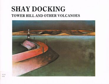
Book - TOWER HILL AND OTHER VOLCANOES
A book titled ' Tower Hill and Other Volcanoes a survey ' by Shay Docking. Warrnambool Art Gallery February - March 1987. Bendigo Art Gallery April 1987. Swan Hill Regional Art Gallery May - June 1987. Supported by the Telecom Exhibition Development Fund. Photography by Gil Docking and Greg Weight. Publislhed by the Warrnambool Art Gallery, February, 1987.artwork, tower hill, book, books, artist, tower hill, volcanoes, shay docking, female, person, individual, warrnambool art gallery, artwork, sciences, photography, place, david hansen, gil docking, survey, exhibition -
 Bendigo Historical Society Inc.
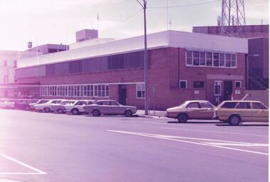
Photograph - CASTLEMAINE GAS COMPANY COLLECTION: PHOTO SEC BUILDING
SEC Building in Williamson Street. A variety of vehicles angle parked along Williamson Street, bas of the communications tower can be seen.bendigo, streetscape, williamson street -
 Bendigo Historical Society Inc.
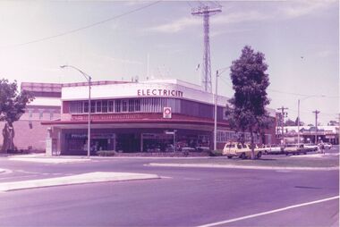
Photograph - CASTLEMAINE GAS COMPANY COLLECTION: PHOTO SEC BUILDING
Photo of SEC Building at the corner of Williamson and Hargreaves Streets. Tree planted on the roundabout, Tall communications tower in the background, two people standing the safety zone, white station wagon, other cars parked along Williamson Street.bendigo, streetscape, williamson street -
 Bendigo Historical Society Inc.
Photograph - CASTLEMAINE GAS COMPANY COLLECTION: PHOTO MALDON
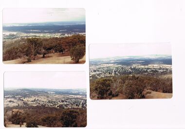
3 photos of the township of Maldon taken from the tower located on Mt Tarrengower overlooking the town.Kodakplace, landscape view, maldon -
 Bendigo Historical Society Inc.
Postcard - ELAINE ROBB COLLECTION: SCHOOL OF MINES BUILDING, BENDIGO
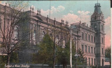
Hand coloured postcard: image shows School of Mines, Pall Mall, Bendigo. Ornate iron fence on edge of footpath, two and three storey sections of building, with tower on RH side. Possibly late 1890's ? On rear of card: Post Card, Inland 1/2d stamp, foreign 1d. Printed in Britain.bendigo, buildings, school of mines, bendigo -
 Bendigo Historical Society Inc.
Newspaper - JENNY FOLEY COLLECTION: EASTER PARADE
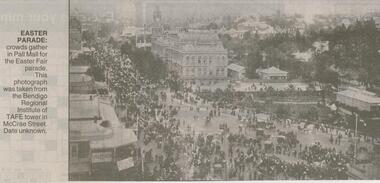
Bendigo Advertiser ''The way we were'' from Saturday, April 14, 2001. Easter parade: crowds gather in Pall Mall for the Easter Fair parade. This photograph was taken from the Bendigo Regional Institute of TAFE tower in McCrae Street. Date unknown. The clip is in a folder.newspaper, bendigo advertiser, the way we were -
 Bendigo Historical Society Inc.
Document - BADHAM COLLECTION: EXHIBITION LABELS X 15 - CARDBOARDS
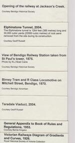
Exhibition labels x 15 - cardboards Railway Post Office stamps, 1865, and book 1951 - Courtesy Edna Westhead. Copy of 1887 Map of Railway Post Offices - Courtesy Edna Westhead Taken in 1921, Bendigo railway men celebrating 50 years since first train arrived in Bendigo in 1862 - Courtesy Bendigo Historical Society Book of Signals, 1949 - Courtesy Bernie Kingdon Book of Instruction Rolling Stock 1921, 1943 - Courtesy Bernie Kingdon Lost Property Book, 1886 - Courtesy Ross Rowley View of Bendigo Railway Station taken from St. Paul's tower, 1875 - Courtesy Bendigo Historical Society...document, memo, railway -
 Bendigo Historical Society Inc.
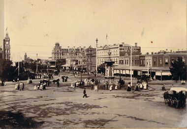
Photograph - ALEXANDRA FOUNTAIN, BENDIGO
Sepia image: image, mounted on board, Alexandra Fountain at Charing Cross, looking north up Pall Mall. On LH side of image, Post Office tower visible, hansom cabs in forefront. Shops along Pall Mall on RH side: Emery & Gibson, Henderson & Goodisson, Beehive, Furniture and Drapery. People in image - women wearing long dresses, hats, men in suits.bendigo, streetscape, alexandra fountain, bendigo, sandhurst, alexandra fountain, hansom cab, post office, henderson & dodisson -
 Bendigo Historical Society Inc.
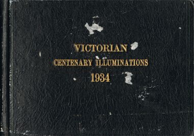
Photograph - VICTORIAN CENTENARY ILLUMINATIONS 1934
Photo album, brown hard cover, writing in gold leaf ' Victorian Centenary Illuminations 1934' Contains black and white images of Melbourne, taken at night. Includes, south bank of Yarra, Princes Bridge, Collins Street, Flinders Street, Elizabeth Street, Shrine of Remembrance, St. Kilda, Swanston Street, Hawthorn War Memorial, State Electricity Commission Head Office, Electricity supply Building, Electricity Commission and Port Authority buildings, South Melbourne Town hall, Hotel Windsor, Parliament House, Town hall, Fire Brigade building, State Savings Bank, National Bank, Melbourne town hall, Bank of Australia, Port Authority Building, Steam Tower. All the photographs in this album pertain to the City of Melbourne, and have NOT been scanned.cottage, miners, melbourne, melbourne, centenary -
 Bendigo Historical Society Inc.
Document - BELL-TOPPER AND TOWER
Typed article from the Centenary Edition of Bendigo Advertiser (1951). It mentions the last day of school for the year when the pupils assembled in the grounds and sang a song composed by the headmaster. The headmaster stood in the school tower. Also a small article on a man who bought a bottle of perfume.document, newspaper, bendigo advertiser, bell-topper and tower, bendigo advertiser, tom hill, rae's school, bunny rae, henry lawson, the ghosts of many christmases -
 Bendigo Historical Society Inc.
Postcard - LANDSCAPE VIEW OF BENDIGO FROM ST. PAUL'S TOWER, BENDIGO
Sepia post card, printed on back 'Post Card, printed in Australia, R.E.M. Series' Image shows Bendigo buildings, looking northwards from St. Paul's Tower, Myer St., Bendigo.R.E.M Series, melbourneplace, landscape view, bendigo, bendigo, landscape view -
 Bendigo Historical Society Inc.
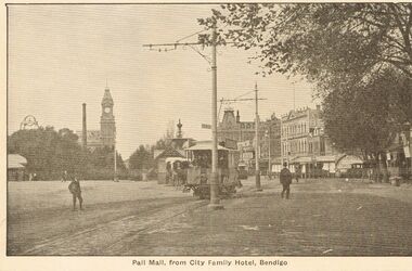
Postcard - PALL MALL, FROM CITY FAMILY HOTEL, BENDIGO
Sepia post card, printed on back 'Post Card, printed in Australia, R.E.M. Series' Image shows Pall Mall, looking north, taken from City Family Hotel position. Tram in centre of image heading south. Post office tower on RH side, top of poppet head visible. Horse and cart on LH side of tram.R.E.M Series Melbourneplace, streetscape, pall mall, pall mall, bendigo, city family, tram, horse and cart -
 Bendigo Historical Society Inc.
Photograph - BENDIGO PHOTO FOLDER
Gray covered photo folder, includes photos of Rosalind Park, Lake Weeroona boatsheds, conservatory, Pall Mall, Queens Gardens, lookout poppet head, panorama frog m lookout tower, Bendigo.Early 1900'splace, bendigo, view of bendigo -
 Bendigo Historical Society Inc.
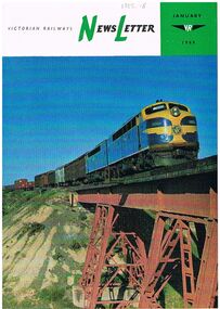
Magazine - BADHAM COLLECTION: VICTORIAN RAILWAYS NEWSLETTER JANUARY 1969
Victorian Railways Newsletter January 1969. Newsletter printed in glossy paper with colour photos on front. The contents include photos of Melbourne's West Tower signal box also a related article, Powelltown in 1919, horse train on Sanderson's line at turn of the century. Printed at the Victorian railways printing works Laurens St North Melbourne.magazine, government, victorian railways -
 Bendigo Historical Society Inc.
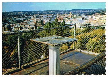
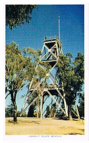
Postcard - LOOKOUT TOWER, ROSALIND PARK
Postcard: image shows landscape view of Bendigo, taken from Lookout Tower, Rosalind Park. On back ' Bendigo, Victoria, panormama of Bendigo from Rosalind Park Lookout Tower' Nu Color Vue, BE 39.Nu Color Vue BE39, Copyrightbendigo, hospital, bendigo, rosalind park, lookout tower -
 Bendigo Historical Society Inc.
Postcard - LOOKOUT TOWER ROSALIND PARK BENDIGO
Postcard: poppet head lookout tower, Rosalind Park, Bendigo. Image shows poppet head, eucalypt trees surrounding it. On bottom ' Lookout Tower, Bendigo' On back 'situated 92 miles north of Melbourne, Bendigo is the gateway to Northern Victoria. It is an attractive City with many modern facilities, fine Gardens and Cultural centres.Nucolorvue Productions, No. 12, Copyright.bendigo, buildings, lookout tower, rosalind park, bendigo, lookout tower, poppethead, rosalind park -
 Bendigo Historical Society Inc.
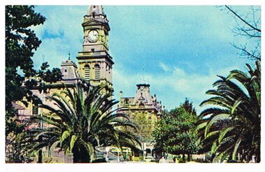
Postcard - POST OFFICE
Postcard: Image shows Bendigo Post Office, viewed from Pall Mall. Palm trees in foreground. On back ' Post Office Bendigo, Victoria' Built in the Italian renaissance style, and opened to the public in 1887, this fine building with its 142 foot clock tower is a local land mark.Plastichrome, Murfett Publishersbendigo, buildings, post office, post office, bendigo, italian renaissance, plastichrome, murfett publishers -
 Bendigo Historical Society Inc.
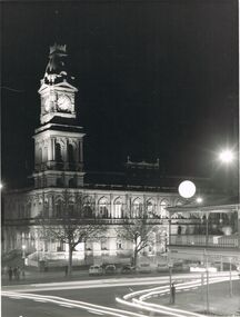
Photograph - POST OFFICE BUILDING, PALL MALL, BENDIGO
black and white image: image of Post Office building, taken at night. Building is illuminated. Clock on tower shows 8.05. Group of people looking at building ( bottom LH side of image ) Cars parked along street, verandah of Shamrock Hotel in foreground. C 1970's ?bendigo, buildings, post office, bendigo, post office, pall mall, shamrock hotel -
 Bendigo Historical Society Inc.
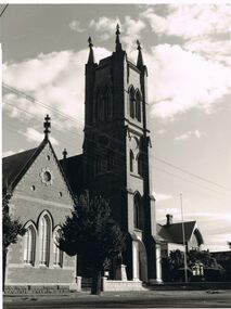
Photograph - ST. PAUL'S CATHEDRAL, MYER STREET, BENDIGO
black and white image:St Paul's Cathedral, hall, and Manse. brick church, four storey bell tower, brick building alongside.bendigo, church, st. paul's church, bendigo, st. paul's, church -
 Bendigo Historical Society Inc.
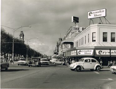
Photograph - PALL MALL & MITCHELL STREETS CORNER
black and white photo: image shows corner of Pall Mall and Mitchell Streets, Bendigo, looking north up Pall Mall. Cars on road in both directions. Ezywalkin Shoes building on corner, The Beehive sign evident. Post Office clock tower in background left hand side.bendigo, streetscape, pall mall and mitchell street corne, bendigo, sandhurst, pall mall, mitchell street -
 Bendigo Historical Society Inc.
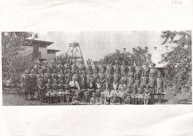
Photograph - SCHOOL PHOTO - LARGE GROUP OF STUDENTS
Photocopy of photo: image shows large group of 54 girls, two teachers, two small boys sitting cross legged in front. Girls are wearing blazers, tunics, shirts, ties. Elevated wooden building on LH side rear, poppet in background centre and building on RH side rear. ( building has unusual number of ventilation towers along ridge line. Unknown school. Could be Girton ?bendigo, education, group photo of students, bendigo, girton, school, group photo -
 Bendigo Historical Society Inc.
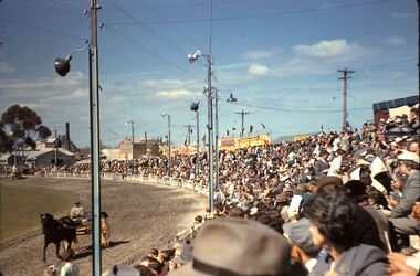
Slide - FLEMING COLLECTION: 1950S BENDIGO SLIDE, 1950s
Bendigo 1950s. Bendigo Easter Procession. Easter Monday was 7 April 1958. Horse and gig going around outside of arena. Spectators area appears full and more spectators standing at the back. The shed behind the pavilion is the old Ice Works building with cooling towerKodachromeevent, easter fair, bendigo easter fair, bendigo 1950s. bendigo easter procession. easter monday was 7 april 1958. horse and gig going around outside of arena. spectators area appears full and more spectators standing at the back. shed behind pavilion old ice works building cooling tower -
 Bendigo Historical Society Inc.
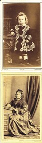
Photograph - 2 CARTE DE VISTE
Two small portrait photographs by N.White Photographer Mitchell Street Sandhurst opposite St Pauls Tower, one of a small child with arm resting on a book on chair with initials MB written on back, the other of a woman seated at a Davenport with book.N.White.photograph, portrait, lady & child -
 Bendigo Historical Society Inc.
Document - LYDIA CHANCELLOR COLLECTION: PICTURES
A large folder containing many pictures taken from a variety of sources. Sources include 'The Illustrated London News,' 'The Sun' and 'Woman's Day and Home.' 1933 - 1963.The Illustrated London News,' 'The Sun' and 'Woman's Day and Homeephemera, mementoes, history, lydia chancellor, collection, photos, pictures, ephemera, botany, plants, flowers, royal yacht britannia, history, british royal family, royalty, coronation, motor car history, automobile history, vintage cars, veteran cars, birds, art history, architecture, theatre, buildings, geography, adam lindsay gordon, australian poetry, children's games, australian art, albert namatjira, melbourne, christianity, religion, advertisements, london, tower of london, thames, river thames, brisbane, sydney, boats, ships, events, entertainment, exploration, heritage -
 Bendigo Historical Society Inc.
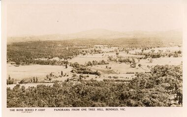
Postcard - ONE TREE HILL PANORAMA POSTCARD
Rose Series P 10397 postcard. Panorama from One Tree Hill, Bendigo Vic.Rose Stereograph Cobendigo, parks and gardens, lookout tower view