Showing 299 items
matching upper yarra valley
-
 Mt Dandenong & District Historical Society Inc.
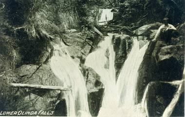
Photograph, Lower Olinda Falls
Copy of postcard captioned - Lower Olinda Falls that has a young man sitting on rocks at the upper LHS. This young man has been identified as Fred Dorey, brother of Iris Woolrich nee Dorey. The suggested date is after 1897 but before 1905. The Upper Olinda Falls can be seen in the background.Printed on front: Lower Olinda Fallsfred dorey, olinda falls, lower olinda falls, olinda -
 Mt Dandenong & District Historical Society Inc.
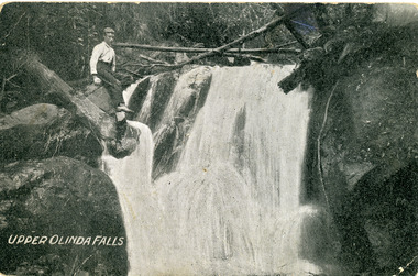
Photograph, Upper Olinda Falls
original post card showing young man sitting on rock at the top of the Falls, LHS. Caption on front is Upper Olinda Falls. Writing on back of postcard identifies the young man as Fred Dorey, brother of Iris Woolrich nee Dorey and the date as between 1897 and 1905.Handwritten on back of card in blue pen: Fred Dorey at Olinda Falls (after 1897 before 1905) Printed on front of card: Upper Olinda Fallsolinda falls, upper olinda falls, fred dorey, olinda -
 Mt Dandenong & District Historical Society Inc.
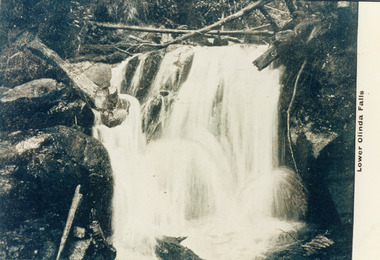
Photograph, Lower Olinda Falls
Copy of a postcard labelled Lower Olinda Falls. There is an original postcard in the collection depicting the same image but with a young man sitting on a rock upper LHS. That postcard identifies the area as Upper Olinda Falls - which is correct.Printed on front: Lower Olinda Fallsolinda falls, lower olinda falls, upper olinda falls, olinda -
 Mt Dandenong & District Historical Society Inc.
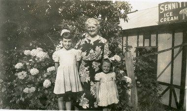
Photograph, Group Outside Quamby Cafe Olinda, c1950s
Older woman with two young girls posed in front of hydrangea bush outside the Quamby Café at Olinda c 1950s. Sennitt's Ice Cream sign visible upper RHS.quamby, quamby cafe, olinda, sennitts icecream -
 Mt Dandenong & District Historical Society Inc.
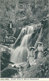
Photograph, Olinda Falls at Mt Dandenong, Early 1900s
Photograph from the Dower family collection taken of the Upper Olinda Falls in the early 1900s. The two men, two women and young boy are all well dressed and posing for a photograph.Black and white photograph received as a jpeg digital image 576KB showing two womwn, two men and a boy at the Olinda Falls early 1900s.On front of image: Early 1900s Olinda Falls at Mt Dandenongolinda falls, mt dandenong, mount dandenong, falls, upper olinda falls -
 Mt Dandenong & District Historical Society Inc.
Photograph, Thomas Hand 1839-1888
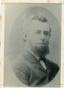
Copy of a formal photograph showing head and shoulders of Thomas Hand, 1839-1888. This photograph has a detailed inscription on the back handwritten by John Lundy-Clarke in 1974.Thomas Hand 1839-1888 Surveyor for Upper Yarra Road Board 1862-1872. Engineer for Shire of Lillydale 1872-1888. Father of Kate, Eva, Eliza, Florence, Mabel, Alice, Frederick and William. Married Eliza Erith 1862. Owner of “Mountain Grange” in the present district of Kalorama. Copy of photograph in possession of his daughter Mabel made by JLC in 1974. thomas hand, mountain grange -
 Southern Sherbrooke Historical Society Inc.
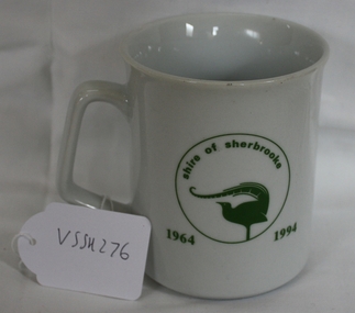
Souvenir Mug, 1994
A mug made for the staff/community party to mark the end of the Shire of Sherbrooke municipality after amalgamation with Lilydale, Healesvill and Upper Yarra councils to form the Shire of Yarra Ranges in 1995.Souvenir mug to celebrate the Shire of Sherbrooke after amalgamation.On one side says "Sherbrooke Farewell" on other side "Shire of Sherbrooke 1964-1994" with the Shire of Sherbrooke Lyrebird logo within a circle. Underneath "CS Hose Glassware Pty Ltd Glass and Ceramic Decorators Est 1945 ph 03-7811966. Blank made in China designed and decorated in Australia."sherbrooke, souvenirs -
 Southern Sherbrooke Historical Society Inc.
Book - Local History, Sherbrooke Foothills Historical Society, Reflections Of The Past, 1998
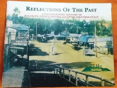
pp. 84, soft cover, historical photographs of Belgrave, Tecoma, Upwey and Upper Ferntree Gully. Locations, buildings, identities, with notes. Loose A4 sheet "Errata & Adenda" -
 Southern Sherbrooke Historical Society Inc.
Information folder - Dandenong Ranges Music Council, 2000
Program for the performance of "The Ballad Of Birdsland", a community music event taking place at Birdsland Reserve, Belgrave, and at Belgrave Heights Convention Centre, Belgrave Heights, on 28 May 2000. Includes project description, profiles of creative team and principle musicians, list of items and list of participants. A5 blue booklet, 3 copies. Program and lyrics of The Fire Cycle, performed at the Belgrave Heights Convention Centre, 8 & 9 October 2005, by DRMC in conjunction with UYCFP, local schools, CFA brigades, local musicians and performers, and the Southern Sherbrooke Historical Society. A5 coloured booklet. Certificate presented to Susan Heywood-Downard for her contribution to "The Fire Cycle"birdsland reserve, john shortis, dandenong ranges music council, upper yarra community forests program -
Southern Sherbrooke Historical Society Inc.
Information Folder - St. Bartholomew's Anglican Church, Ferntree Gully and St. Thomas' Anglican Church, Upper Ferntree Gully
Information folder containing items pertaining to the history of St. Bartholomew's Anglican Church, Ferntree Gully and St. Thomas' Anglican Church, Upper Ferntree Gully. Contents: -letter, Bob Collie to Susan Heywood-Downard, dated 12 October 1995 -photo, Rev. W. M. Robertson -photo, "Rev. W. G. Thomas 1913-1918" -photo, "St. Bartholomew's/Ferntree Gully/Station St -Lower FTG/No longer there" -photo, aerial shot of Ferntree Gully township, "Mr Curlewis, Gacidal (?) St, North Bayswater. The clergy house is at the extreme RH of photo, on top of hill. It is no longer there on 'The Avenue'" -booklet, "The Anglican Church of St. Thomas, Upper Ferntree Gully. A Short Guide & brief history" by Brian Kennedy, June 1993 -booklet, "The Church of England, St. Bartholomew's Ferntree Gully Lower, St. Thomas', Ferntree Gully Upper. Combined Funds Canvass - 1957"st. bartholomew's anglican church, ferntree gully, st. thomas' anglican church, upper ferntree gully. -
Southern Sherbrooke Historical Society Inc.
Information folder - Fires 2003, 2003
Folder containing information pertaining to the 2003 Victorian, NSW & ACT bushfires. Contents: -3 photos of Omeo after the fires, by Dulcie Strahan -DSE/DPI Fire Update report dated 21st February -2 photos of fires in North-east Victoria by Andrew Aubert -3 Fire Overview maps, dated 24 January, 27 January (2 copies) and 16 February -leaflet, "Upper Murray Fires", community update, dated 12 January -copy of fire overview map, dated 16 February, with annotations -weather page, Border Mail, 8 Januarybushfires -
 Southern Sherbrooke Historical Society Inc.
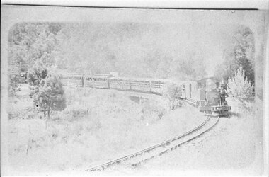
Photograph - Puffing Billy leaving Upper Ferntree Gully
Puffing Billy rounding a corner surrounded by grass and trees. Possibly near the bridge at Upper Ferntree Gully. -
 Kew Historical Society Inc
Photograph - Yarra in Flood from Willsmere, North Kew, 1923
Flooding of the Yarra Valley, including that section of the Yarra bordering Kew and Kew East in the north and west of the municipality, was a regular occurrence. Extreme flood events of the Yarra River are recorded to have occurred in 1891, 1901, 1916, 1923 and 1934. The Municipality of Kew's response to these floods was to enact planning decisions restricting residential development in flood prone areas following the floods of 1916, 1921 and 1934. While floods continued after the development of the Upper Yarra Reservoir (construction 1948-57), the regularity and extent of these inundations diminished. Original, large sepia photograph showing men, women and children who have gathered on a grassy verge, probably farm land, to look out across the flooded Yarra Valley at Willsmere, North Kew. In the medium distance are three houses that are largely submerged by the flood waters as well as a number of Eucalypts. Judging by the clothes of the spectators, the date might be 1901 or 1916, but probably the latter due to the hats worn by a number of the women. Inscribed reverse: "Gift of Kerrie Woollard (KCC) (P)C.1923yarra river valley, kew east (vic.), floods, willsmere -
 Kew Historical Society Inc
Photograph - Flood at Fairfield Park, 1934
Flooding of the Yarra Valley, including that section of the Yarra bordering Kew and Kew East in the north and west of the municipality, was a regular occurrence. Extreme flood events of the Yarra River are recorded to have occurred in 1891, 1901, 1916, 1923 and 1934. The Municipality of Kew's response to these floods was to enact planning decisions restricting residential development in flood prone areas following the floods of 1916, 1921 and 1934. While floods continued after the development of the Upper Yarra Reservoir (construction 1948-57), the regularity and extent of these inundations diminished.Black and white print positive. Yarra River at Fairfield in 1934. Major flood resulting in submerged buildings in middle ground and onlookers on far bankReverse: "Flood of Yarra at Fairfield Park 1934"fairfield park, yarra valley, river yarra, floods -- 1934 -
 Kew Historical Society Inc
Photograph - Yarra in Flood, 1934
Flooding of the Yarra Valley, including that section of the Yarra bordering Kew and Kew East in the north and west of the municipality, was a regular occurrence. Extreme flood events of the Yarra River are recorded to have occurred in 1891, 1901, 1916, 1923 and 1934. The Municipality of Kew's response to these floods was to enact planning decisions restricting residential development in flood prone areas following the floods of 1916, 1921 and 1934. While floods continued after the development of the Upper Yarra Reservoir (construction 1948-57), the regularity and extent of these inundations diminished.Black and white print positive. 1934 floods of the Yarra Valley. Location Fairfield looking towards wooded hillside. Houses floating in river.Reverse: "From Fairfield Park (11936?) back towards hill (Wurundjeri Spur?)"floods -- 1934, yarra valley, yarra river, fairfield park -
 Kew Historical Society Inc
Photograph - River Yarra in Flood from Kilby Road
Flooding of the Yarra Valley, including that section of the Yarra bordering Kew and Kew East in the north and west of the municipality, was a regular occurrence. Extreme flood events of the Yarra River are recorded to have occurred in 1891, 1901, 1916, 1923 and 1934. The Municipality of Kew's response to these floods was to enact planning decisions restricting residential development in flood prone areas following the floods of 1916, 1921 and 1934. While floods continued after the development of the Upper Yarra Reservoir (construction 1948-57), the regularity and extent of these inundations diminished.Print copy of an original photo of the River Yarra in Flood, taken from Kilby Road.VIEW ACROSS YARRA IN FLOOD / FROM KILBY RD KEWkilby road, floods -- kew (vic.), kilby farm -
Kew Historical Society Inc
Collection, Floods in North Kew (Series), 1929–1934
Flooding of the Yarra Valley, including that section of the Yarra bordering Kew and Kew East in the north and west of the municipality, was a regular occurrence. Extreme flood events of the Yarra River are recorded to have occurred in 1891, 1901, 1916, 1923 and 1934. The Municipality of Kew's response to these floods was to enact planning decisions restricting residential development in flood prone areas following the floods of 1916, 1921 and 1934. While floods continued after the development of the Upper Yarra Reservoir (construction 1948-57), the regularity and extent of these inundations diminished. Natural disasters had an impact on the development and settlement of Melbourne and its suburbs. Flooding in the Melbourne region was a regular event in the nineteenth and for most of the twentieth centuries. Changes in the impact of natural disasters could occur due to a number of factors. This collection of small snapshots, mostly taken from Kellett Grove in North Kew, provide provenanced evidence of flooding in the area before the development of the unnatural flood barrier that is the Eastern Freeway.Collection of 16 monochrome photographs, annotated on verso by different hands, of the flooding of the River Yarra in North Kew in the third and fourth decades of the twentieth century [1920s & 1930s]. Individual photos include the dates of different floods. Many of the photos were taken from the rear of 8 Kellett Grove; a house still extant in 2023yarra river -- north kew, floods -- yarra valley, floods -- north kew, floods -- 1929, floods -- 1934, natural disasters -- kew -
 Kew Historical Society Inc
Photograph - Yarra Valley Floods: Kew East, 1916
Flooding of the Yarra Valley, including that section of the Yarra bordering Kew and Kew East in the north and west of the municipality, was a regular occurrence. Extreme flood events of the Yarra River are recorded to have occurred in 1891, 1901, 1916, 1923 and 1934. The Municipality of Kew's response to these floods was to enact planning decisions restricting residential development in flood prone areas following the floods of 1916, 1921 and 1934. While floods continued after the development of the Upper Yarra Reservoir (construction 1948-57), the regularity and extent of these inundations diminished. During the nineteenth century, the land abutting the south side of the Yarra in Kew was devoted to dairy farming. In the twentieth century, before and after the construction of the Eastern Freeway, much of this low-lying area was used as golf courses and public parks.One of a collection of photographs of flooding in the Kew section of the Yarra Valley which are in important research resource for the location and extent of flooding in the first half of the twentieth century. Flooding of the Yarra Valley at East Kew in 1916. The view is taken from the intersection of Kilby Road with what is believed to be Birdwood Street, looking across the flood waters to Ivanhoe. The extensive flooded area shown in the photograph would have included the Kew Golf Club. Verso: "Floods along Kilby Road / near Birdwood St? & Kilby Road / 1917? / 87yarra river, yarra valley, floods -- kew, kilby road -- kew (vic.), kew golf club -
 Kew Historical Society Inc
Photograph - Yarra Valley Floods: Kew East, 1916
Flooding of the Yarra Valley, including that section of the Yarra bordering Kew and Kew East in the north and west of the municipality, was a regular occurrence. Extreme flood events of the Yarra River are recorded to have occurred in 1891, 1901, 1916, 1923 and 1934. The Municipality of Kew's response to these floods was to enact planning decisions restricting residential development in flood prone areas following the floods of 1916, 1921 and 1934. While floods continued after the development of the Upper Yarra Reservoir (construction 1948-57), the regularity and extent of these inundations diminished. During the nineteenth century, the land abutting the south side of the Yarra in Kew was devoted to dairy farming. In the twentieth century, before and after the construction of the Eastern Freeway, much of this low-lying area was used as golf courses and public parks.One of a collection of photographs of flooding in the Kew section of the Yarra Valley which are in important research resource for the location and extent of flooding in the first half of the twentieth century. Flooding of the Yarra Valley at East Kew in 1916. The view is taken from a street (maybe Birdwood Avenue) intersecting with Kilby Road looking northeast across the flood waters to Ivanhoe and Heidelberg. The extensive flooded area shown in the photograph would have included remnant dairy farms and the Kew Golf Club. Verso: "Floods / Yarra River / East Kew / Kilby Road / 1917? / 87"yarra river, yarra valley, floods -- kew, kilby road -- kew (vic.), kew golf club -
 Kew Historical Society Inc
Photograph - Flooding of the Yarra Valley at Kew East, 1974
Flooding of the Yarra Valley, including that section of the Yarra bordering Kew and Kew East in the north and west of the municipality, was a regular occurrence. Extreme flood events of the Yarra River are recorded to have occurred in 1891, 1901, 1916, 1923 and 1934. The Municipality of Kew's response to these floods was to enact planning decisions restricting residential development in flood prone areas following the floods of 1916, 1921 and 1934. While floods continued after the development of the Upper Yarra Reservoir (construction 1948-57), the regularity and extent of these inundations diminished. During the nineteenth century, the land abutting the south side of the Yarra in Kew was devoted to dairy farming. In the twentieth century, before and after the construction of the Eastern Freeway, much of this low-lying area was used as golf courses and public parks.Late example of the capacity of the Yarra Valley at Kew to flood, even though drainage works and the Upper Yarra Reservoir had reduced their regularity.Original black and white print photograph of the low-lying land at East Kew under floodwater on 16 May 1974. The vantage point of the photographer is Lister Street. In the photo, the fences of the Kilby Farm can be seen. Flooding was caused by overflowing water in Glass' Creek and the River Yarra. Annotation verso: "Hay's Paddock op No.30 Lister Street / 16 May 1974 11.50am / R.L. 46.04"hays paddock, floods, yarra river, glass' creek, lister street -
 Kew Historical Society Inc
Photograph - Flooding of the Yarra Valley at Kew East, 1974
Flooding of the Yarra Valley, including that section of the Yarra bordering Kew and Kew East in the north and west of the municipality, was a regular occurrence. Extreme flood events of the Yarra River are recorded to have occurred in 1891, 1901, 1916, 1923 and 1934. The Municipality of Kew's response to these floods was to enact planning decisions restricting residential development in flood prone areas following the floods of 1916, 1921 and 1934. While floods continued after the development of the Upper Yarra Reservoir (construction 1948-57), the regularity and extent of these inundations diminished. During the nineteenth century, the land abutting the south side of the Yarra in Kew was devoted to dairy farming. In the twentieth century, before and after the construction of the Eastern Freeway, much of this low-lying area was used as golf courses and public parks.Late example of the capacity of the Yarra Valley at Kew to flood, even though drainage works and the Upper Yarra Reservoir had reduced their regularity.Original black and white print photograph of the low-lying land at East Kew under floodwater on 16 May 1974. The vantage point of the photographer is Lister Street. Flooding was caused by overflowing water in Glass' Creek and the River Yarra. Annotation verso: "Lister Street looking north / Flood level / 16 May 1974 11.30am / R.L. 46.04"hays paddock, floods, yarra river, glass' creek, lister street -
 Kew Historical Society Inc
Photograph - Flooding of the Yarra Valley at Kew East, 1974
Flooding of the Yarra Valley, including that section of the Yarra bordering Kew and Kew East in the north and west of the municipality, was a regular occurrence. Extreme flood events of the Yarra River are recorded to have occurred in 1891, 1901, 1916, 1923 and 1934. The Municipality of Kew's response to these floods was to enact planning decisions restricting residential development in flood prone areas following the floods of 1916, 1921 and 1934. While floods continued after the development of the Upper Yarra Reservoir (construction 1948-57), the regularity and extent of these inundations diminished. During the nineteenth century, the land abutting the south side of the Yarra in Kew was devoted to dairy farming. In the twentieth century, before and after the construction of the Eastern Freeway, much of this low-lying area was used as golf courses and public parks.Late example of the capacity of the Yarra Valley at Kew to flood, even though drainage works and the Upper Yarra Reservoir had reduced their regularity.Original black and white print photograph of Hay's Paddock under floodwater on 16 May 1974. The vantage point of the photographer is Keystone Crescent looking east. Flooding was caused by overflowing water in Glass' Creek and the River Yarra. Annotation verso: "Keystone Cr looking east / 16 May 1974 11.50am"hays paddock, floods, yarra river, glass' creek -
 Kew Historical Society Inc
Photograph - Flooding of the Yarra Valley at Kew East, 1974
Flooding of the Yarra Valley, including that section of the Yarra bordering Kew and Kew East in the north and west of the municipality, was a regular occurrence. Extreme flood events of the Yarra River are recorded to have occurred in 1891, 1901, 1916, 1923 and 1934. The Municipality of Kew's response to these floods was to enact planning decisions restricting residential development in flood prone areas following the floods of 1916, 1921 and 1934. While floods continued after the development of the Upper Yarra Reservoir (construction 1948-57), the regularity and extent of these inundations diminished. During the nineteenth century, the land abutting the south side of the Yarra in Kew was devoted to dairy farming. In the twentieth century, before and after the construction of the Eastern Freeway, much of this low-lying area was used as golf courses and public parks.Late example of the capacity of the Yarra Valley at Kew to flood, even though drainage works and the Upper Yarra Reservoir had reduced their regularity.Original black and white print photograph of the low-lying land at East Kew under floodwater on 16 May 1974. The vantage point of the photographer is Lister Street. Flooding was caused by overflowing water in Glass' Creek and the River Yarra. Annotation verso: "Lister St looking same as No.3 / 16 May 1974 11.30"floods, yarra river, glass' creek, lister street -
 Kew Historical Society Inc
Photograph - Flooding of the Yarra Valley at Kew East, 1974
Flooding of the Yarra Valley, including that section of the Yarra bordering Kew and Kew East in the north and west of the municipality, was a regular occurrence. Extreme flood events of the Yarra River are recorded to have occurred in 1891, 1901, 1916, 1923 and 1934. The Municipality of Kew's response to these floods was to enact planning decisions restricting residential development in flood prone areas following the floods of 1916, 1921 and 1934. While floods continued after the development of the Upper Yarra Reservoir (construction 1948-57), the regularity and extent of these inundations diminished. During the nineteenth century, the land abutting the south side of the Yarra in Kew was devoted to dairy farming. In the twentieth century, before and after the construction of the Eastern Freeway, much of this low-lying area was used as golf courses and public parks.Late example of the capacity of the Yarra Valley at Kew to flood, even though drainage works and the Upper Yarra Reservoir had reduced their regularity.Original black and white print photograph of the low-lying land at East Kew under floodwater on 16 May 1974. The vantage point of the photographer is at Willsmere Road. The road itself is underwater.Annotation verso: "Willsmere Rd / Same as No.7 / 16 May 1974 11.15am"floods, yarra river, willsmere road -
 Kew Historical Society Inc
Photograph - Flooding of the Yarra Valley at Kew East, 1974
Flooding of the Yarra Valley, including that section of the Yarra bordering Kew and Kew East in the north and west of the municipality, was a regular occurrence. Extreme flood events of the Yarra River are recorded to have occurred in 1891, 1901, 1916, 1923 and 1934. The Municipality of Kew's response to these floods was to enact planning decisions restricting residential development in flood prone areas following the floods of 1916, 1921 and 1934. While floods continued after the development of the Upper Yarra Reservoir (construction 1948-57), the regularity and extent of these inundations diminished. During the nineteenth century, the land abutting the south side of the Yarra in Kew was devoted to dairy farming. In the twentieth century, before and after the construction of the Eastern Freeway, much of this low-lying area was used as golf courses and public parks.Late example of the capacity of the Yarra Valley at Kew to flood, even though drainage works and the Upper Yarra Reservoir had reduced their regularity.Original black and white print photograph of the low-lying land at East Kew under floodwater on 16 May 1974. The photograph is of Hyde Park looking north-east.Annotation verso: "Hyde Park looking nth-east / Flood Level / 16 May 1974 11.15am / R.L. 46.61"floods, yarra river, hyde park -
 Kew Historical Society Inc
Photograph - Flooding of the Yarra Valley at Kew, 1974
Flooding of the Yarra Valley, including that section of the Yarra bordering Kew and Kew East in the north and west of the municipality, was a regular occurrence. Extreme flood events of the Yarra River are recorded to have occurred in 1891, 1901, 1916, 1923 and 1934. The Municipality of Kew's response to these floods was to enact planning decisions restricting residential development in flood prone areas following the floods of 1916, 1921 and 1934. While floods continued after the development of the Upper Yarra Reservoir (construction 1948-57), the regularity and extent of these inundations diminished. During the nineteenth century, the land abutting the south side of the Yarra in Kew was devoted to dairy farming. In the twentieth century, before and after the construction of the Eastern Freeway, much of this low-lying area was used as golf courses and public parks.Late example of the capacity of the Yarra Valley at Kew to flood, even though drainage works and the Upper Yarra Reservoir had reduced their regularity.Original black and white print photograph of the low-lying land at East Kew under floodwater on 16 May 1974. The photograph is taken from 43 Kellett Grove.Annotation verso: "Kellett Gve No.43 / Flood Level / 16 May 1974 11.40am"floods, yarra river, kellett grove -
 Lilydale RSL Sub Branch
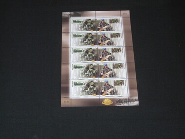
Stamps, 100 Years of Service, 00/02/2001
Photographers: Historical Norman Brown, Contemporary George GitttoesSheetlet of 10x45c stamps. Historical on left: Charles Byrne and G Walker 29th/46th Btn New Guinea 1943 (AWM #16297) smaller image on left Light Horse on parade 1940 (AWM #001329). Contemporary on right: Trooper Jon Church carrying a child in Rwanda (1995) smaller image upper right Officers on Commando Officer Selection course Jul 1997. Selvedge features images of 13th Australian Light Horse in France 1918 (AWM #EO2979) and a soldier greeting the dawn in Balibo and the Rising Sun badge. -
 Lilydale RSL Sub Branch
Stamps
First day cover date stamped 15 Feb 2001 and titled Army 100 Years of Service. Two stamps depicting historical and contemporary images. The upper left image of the covers feature a female soldier -
 Lilydale RSL Sub Branch
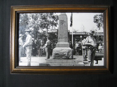
Photograph, David Fowler (Lilydale & Upper Yarra Post), Remembrance Day 1992, 11/11/1992
Framed Photograph -
 Lilydale RSL Sub Branch
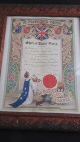
Certificate - Framed Certificate of Thanks and Appreciation, 24/5/1918
Framed Certificate in carved wooden frame headed "In Freedom's Cause"Shire of Upper Yarra ---- The President and Councillors and Ratepayers of the Shire of Upper Yarra Hereby place on record their thanks and Appreciation for the Conduct of Leslie Raymond Jack who served his King and Country in the Great War. In Witness Whereof the Corporate Seal of the Municipality is hereto attached in the presence of.