Showing 389 items
matching water reserve
-
 St Kilda Historical Society
Photograph - Photo map, Department of Crown Lands and Survey (1857-1983), 22/01/1970
One of a series of photo-maps produced for the Department of Crown Lands and Survey (1857-1983). For correlation with a current map, and access to other historical photo maps of Victoria, see the Historic Photo-Maps Index published by the Department of Environment, Land, Water and Planning at https://services.land.vic.gov.au/DELWPmaps/historical-photomaps/Black and white aerial photographVic 2358 Department of Crown Lands and Survey Victoria,.© Melbourne 1970 Project Run 42E 22.1.70 5,100 ASL 77st kilda, st kilda east, st kilda marina, elwood, elwood canal, elsternwick park, point ormond, balaclava, mc moran reserve, ripponlea, st kilda botanical gardens, peanut farm, 1970 -
 St Kilda Historical Society
Photograph - Photo map, Department of Crown Lands and Survey, 22/01/1970
One of a series of photo-maps produced for the Department of Crown Lands and Survey (1857-1983). For correlation with a current map, and access to other historical photo maps of Victoria, see the Historic Photo-Maps Index published by the Department of Environment, Land, Water and Planning at https://services.land.vic.gov.au/DELWPmaps/historical-photomaps/Black and white aerial photographVic 2358 Department of Crown Lands and Survey Victoria,.© Melbourne 1970 Project Run 43E 22.1.70 5,100 ASL 208elwood, elwood beach, point ormond, elwood park, elwood canal, mc moran reserve, 1970 -
 Tatura Irrigation & Wartime Camps Museum
Photograph, New Fence Styles - Irrigation Channels, 1957
Taken by the photographer for Victoria State Rivers and Water Supply Commission.Large black and white photograph Concrete "fence" styles - One male worker handling sample in mid-distance, right of centre.Below photo: "New Fence Styles to enable easy access onto Commission Channel Reserves."irrigation, victoria state rivers and water supply commission, channel maintenance -
Tatura Irrigation & Wartime Camps Museum
Box, Tatura Souvenirs/Royal Visit 1954, Various
Collection of 1954 Royal Visit and Tatura Souvenirs memorbillia. Newspaper - Tatura Guardian - Souvenir of Royal Visit 1954|School Souvenir booklet - Royal Visit|School booklet - Royal Visit - Red cover|School booklet - Royal Visit - Black cover|State Reception Invitation and Booklet to Jack Lowry - Royal Visit|Note Pad - Spiral bound - Royal Family|Photo of Queen arriving at Tatura Railway Station and Entry Card to Station Reserve.|China Plate - Royal Tour.|2Plastic beakers - Royal Visit|1 British Flag|1 Souvenir Royal Flag|Souvenir Royal Flag - Red Cross|Stubby holder - Tatura Waterwheel Country| Glass bowl - Photo of Tatura|Broken - Original RC Church - Jug - C. 1900| China Jug - A View of Tatura| Water Bottle - Tatura Youth Club. C.2005|2 "Get Hooked on Tatura"|3 Tatura Post Cards - C. 1990|Magnet - "Stick with Tatura - 3SR radio|TaturaBeige coloured rectangle boxlocal history, royal visit souvenirs, tatura souvenirs, civic, memento, souvenirs -
Creswick Campus Historical Collection - University of Melbourne
Document, Management Plan for Mt.Beckworth Forest Reserve, c.1966
Hand typed loose covers Management Plan for Mt.Beckworth Forest ReserveDocument -
Lakes Entrance Regional Historical Society (operating as Lakes Entrance History Centre & Museum)
Postcard, Bulmer, 1920 to 1930 c
Black and white postcard showing Main Street Bairnsdale taken from the water tower Bairnsdale VictoriaMain Street Reserves Bairnsdaleships and shipping, shipwrecks -
Stawell Historical Society Inc
Map, Fred W Wright Surveyor, Plan of the Borough of Stawell showing Mining leases & reefs 1870, 1870
Mining details. Including Tramways, Water Races. Crushing Mills. Reefs and Reserves.Copy of Original Showing Stawell Borough with details including mining leases Companies and MillsInsert with details of Sections 23, 34, 35 & 36. Fred W Wright 12 May 1870mining -
 Whitehorse Historical Society Inc.
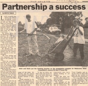
Article, Partnership a success, 26/02/1992 12:00:00 AM
Nunawading Gazette, 26 February 1992 by Merita Tabain on revegetation of Nunawading land owned by Melbourne Water.Article from Nunawading Gazette, 26 February 1992 by Merita Tabain on revegetation of Nunawading land owned by Melbourne Water.Nunawading Gazette, 26 February 1992 by Merita Tabain on revegetation of Nunawading land owned by Melbourne Water.melbourne water, nunawading, forest hill, parks and reserves, pipe line reserve -
 Whitehorse Historical Society Inc.
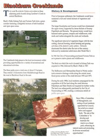
Pamphlet, Blackburn Creeklands, 1/08/1990 12:00:00 AM
Sympathetic treatment of creek banks and preservation and regeneration of bushland will encourage wildlifeSympathetic treatment of creek banks and preservation and regeneration of bushland will encourage wildlife, development of wetlands has encouraged water birds, provision of play equipmentSympathetic treatment of creek banks and preservation and regeneration of bushland will encourage wildlifeparks and reserves, blacks walk, kalang park, furness park, city of nunawading, melbourne and metropolitan board of works, middleborough road, blackburn, pakenham street, blackburn road, gardiners creek, laburnum primary school no. 4863 -
 Whitehorse Historical Society Inc.
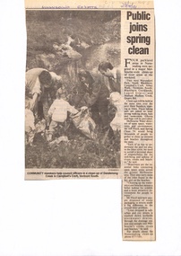
Newspaper - Article, Public joins spring clean, 23/10/1991
Four parkland areas in Nunawading to be included in clean-ups on three Sundays in October under direction of Melbourne Water.parks and reserves, floyd, jeff, wurundjeri walk, campbells croft, blackburn creeklands, mullum mullum creek -
 Whitehorse Historical Society Inc.
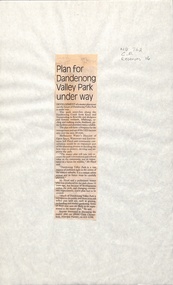
Newspaper - Article, Plan for Dandenong Valley park under way, 1/06/1992
Development of park along Dandenong Creek from Knox and Nunawading to Rowville and Mulgrave featuring wetlands, billabongs, cycling and walking tracks, bushland, picnic facilities and wildlife.dandenong creek, melbourne water, floyd, jeff, dandenong valley metropolitan park, chesterfield, chris, parks and reserves -
 Whitehorse Historical Society Inc.
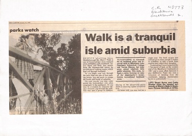
Newspaper - Article, Walk is a tranquil isle amid suburbia, 10/01/1994
Walk developed after land acquired by Nunawading Council at western end of Blackburn Creeklands in 1967.parks and reserves, city of nunawading, melbourne water, blacks walk, middleborough road, blackburn, burns, stuart, bowker, cathy -
 Whitehorse Historical Society Inc.
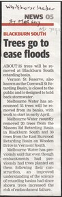
Article, Trees go to ease floods, 2017
Melbourne Water will remove 35 trees from the embankments of the Vernon Street Reserve, also known as the Cornwall Street Retarding Basin, to reduce the risk of embankment failure.trees, blackburn south, vernon street, blackburn, melbourne water -
 Whitehorse Historical Society Inc.
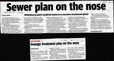
Article, Sewer Treatment Plant, 11/09/2017 12:00:00 AM
... Mitcham melbourne Frank Sedgman Reserve Yarra Valley Water ...Frank Sedgman Reserve could become a giant sewage farm servicing householders in Manningham.Frank Sedgman Reserve could become a giant sewage farm servicing householders in Manningham.Frank Sedgman Reserve could become a giant sewage farm servicing householders in Manningham.frank sedgman reserve, yarra valley water, sewerage and sanitation -
 Rutherglen Historical Society
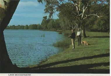
Post Card Folder, Big 7 Folder, Vue Pac. 7 Detachable Post Cards of Rutherglen Victoria, c1970
... of the Murray River. A wildlife reserve incorporating camping and water... River. A wildlife reserve incorporating camping and water sport ...Donated by Mrs Brian Jasper.Coloured post cards in folder with views of Rutherglen and District. This one is a view of Lake MoodemereOn message side of card: "Rutherglen, Victoria. A billabong of the Murray River. A wildlife reserve incorporating camping and water sport facilities. | NCV.1050 Nucolorvue Productions Pty. Ltd."lake moodemere -
 Ballarat Heritage Services
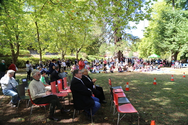
Digital photographs, L.J. Gervasoni, 150 anniversary of the Hepburn Mineral Springs Reserve - crowd, c2006
http://vhd.heritagecouncil.vic.gov.au/places/1993 Digital imageshepburn mineral springs reserve, hepburn mineral springs, hepburn springs, 150, crowd, picnic, anniversary, celebration, community, mineral water, mineral springs -
 Ballarat Heritage Services
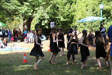
Digital photographs, L.J. Gervasoni, 150 anniversary of the Hepburn Mineral Springs Reserve - welcome to country dancers, 2015
http://vhd.heritagecouncil.vic.gov.au/places/1993 Digital imageshepburn mineral springs reserve, hepburn mineral springs, hepburn springs, 150, crowd, picnic, anniversary, celebration, community, mineral water, mineral springs, welcome to country, dancers -
 Ballarat Heritage Services
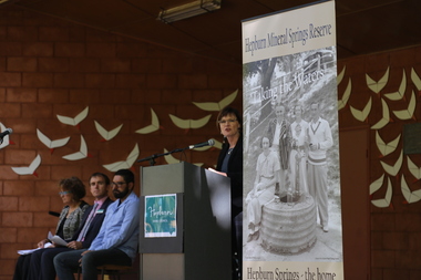
Digital photographs, L.J. Gervasoni, 150 anniversary of the Hepburn Mineral Springs Reserve - official party sound shell, 2015
http://vhd.heritagecouncil.vic.gov.au/places/1993 Digital imageshepburn mineral springs reserve, hepburn mineral springs, hepburn springs, 150, crowd, picnic, anniversary, celebration, community, mineral water, mineral springs, mary-anne thomas mp -
 Ballarat Heritage Services
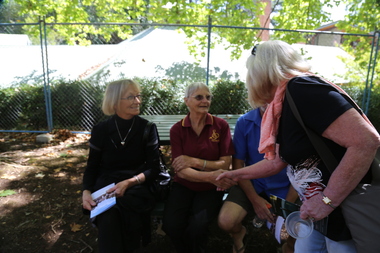
Digital photographs, L.J. Gervasoni, 150 anniversary of the Hepburn Mineral Springs Reserve - Swiss Italian catchup, 2015
http://vhd.heritagecouncil.vic.gov.au/places/1993 Digital imageshepburn mineral springs reserve, hepburn mineral springs, hepburn springs, 150, crowd, picnic, anniversary, celebration, community, mineral water, mineral springs, swiss italian -
 Ballarat Heritage Services
Digital photographs, L.J. Gervasoni, 150 anniversary of the Hepburn Mineral Springs Reserve - Clare and Jenny at the shadow, 2015
http://vhd.heritagecouncil.vic.gov.au/places/1993 Digital imageshepburn mineral springs reserve, hepburn mineral springs, hepburn springs, 150, crowd, picnic, anniversary, celebration, community, mineral water, mineral springs, swiss italian -
 Ballarat Heritage Services
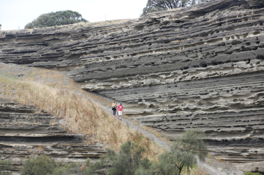
Photograph - Colour, Tower Hill, 2016, 31/12/2016
Tower Hill is a volcanic formation believed to have erupted about 32,000 years ago. Its formation is known as a "nested maar" and it is the largest example of its type in Victoria. During formation, molten lava pushed its way up through the Earth’s crust and encountered a layer of water-bearing rock. Violent explosions followed creating a shallow crater which later filled with water to form the lake. Further eruptions occurred in the centre of this crater, creating the islands and cone shaped hills. In 1892 Tower Hill became Victoria’s first National Park. In 1961, Tower Hill became a State Game Reserve under the then Fisheries and Wildlife Department and a major re-vegetation program began. (https://www.towerhill.org.au/index.php/about-reserve/history, accessed 23 December 2019)A number of photographs taken at Tower Hill, including the lakes, volcanic ash layer, and koala.tower hill, ash layer, volcano -
 Ballarat Heritage Services
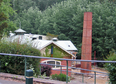
Photograph - digital photographs, Lisa Gervasoni, Hepburn Springs Bathhouse, c2000, c2000
Ccolour photograph of a brick bathouse at Hepburn Mineral Springs Reserve. baths, bathhouse, mineral water, renovation, chimney -
Ballarat Heritage Services
Film - Flooding at Hepburn Mineral Springs Reserve October 7 2022, Lisa Gervasoni, Video of flooding on Wild Cat Creek, 07/10/2022
... Springs Reserve. mineral water wild cat creek locarno mineral ...Wild Car Creek usually gently flows through Hepburn Springs Reserve. After a rainstorm on 05 October the creek flooded, covering the mineral water springs at Hepburn Springs Reserve.Flooding at Wild Car Creek at Hepburn Mineral Springs Reserve flooding at hepburn mineral springs reserve, hepburn springs reserve., mineral water, wild cat creek, locarno mineral water spring -
 Ballarat Heritage Services
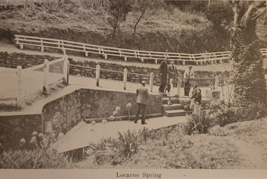
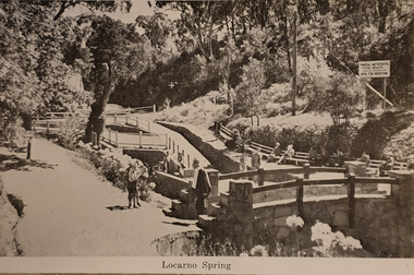
Souvenir - Postcard Booklet, Locarno Springs from Photographic Booklet of Hepburn Springs, Vic, c1945
Hepburn Springs in a tourist town with natural mineral water springsA black and white photographic image of Locarno Spring in the Hepburn Springs Mineral Springs Reserve. hepburn springs, locarno mineral water spring, mineral water, locarno spring -
 Ballarat Heritage Services
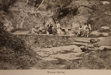
Souvenir - Postcard Booklet, Wyuna Spring from Photographic Booklet of Hepburn Springs, Vic, c1945
Hepburn Springs in a tourist town with natural mineral water springsA black and white photographic image of Wyuna Spring in the Hepburn Springs Mineral Springs Reserve. hepburn springs, mineral water, wyuna spring -
 Ballarat Heritage Services
Souvenir - Postcard Booklet, Locarno Springs from Photographic Booklet of Hepburn Springs, Vic, c1945
Hepburn Springs in a tourist town with natural mineral water springsA black and white photographic image of Locarno Spring in the Hepburn Springs Mineral Springs Reserve. hepburn springs, locarno mineral water spring, mineral water, locarno spring -
 Ballarat Heritage Services
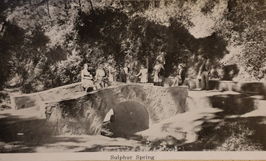
Souvenir - Postcard Booklet, Sulphur Springs from Photographic Booklet of Hepburn Springs, Vic, c1945
Hepburn Springs in a tourist town with natural mineral water springsA black and white photographic image of Sulphur Spring in the Hepburn Springs Mineral Springs Reserve. hepburn springs, mineral water, sulphur spring -
 Ballarat Heritage Services
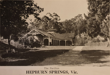
Souvenir - Postcard Booklet, Hepburn Springs Pavilion from Photographic Booklet of Hepburn Springs, Vic, c1945
Hepburn Springs in a tourist town with natural mineral water springsA black and white photographic image of the pavilion in the Hepburn Springs Mineral Springs Reserve. hepburn springs, mineral water, pavilion -
 Ballarat Heritage Services
Souvenir - Postcard Booklet, Bridge Over Spring Creek from Photographic Booklet of Hepburn Springs, Vic, c1945
Hepburn Springs in a tourist town with natural mineral water springsA black and white photographic image of a metal spring in the Hepburn Springs Mineral Springs Reserve. hepburn springs, mineral water, bridge -
 Ballarat Heritage Services
Photograph - Digital photograph, Dorothy Wickham, Winter's Swamp, Ballarat, January to April 2014
Study of Winter's Swamp commissioned by BEN and completed by BHS. The swamp was named after one of the first European settlers in the district. Winter Swamp LAT -37 32 LONG 143 47, Parish of Dowling Forest, County of Grenville Winter Swamp, on the southwest corner of Ballarat West Town Common, was not included in the original proclamation of the Common in 1861. However, being marshland, it was not considered suitable for grazing, so was added to the Common soon after 1861. Winter Swamp is a large wetland with native and exotic pasture significant for wildlife. John Winter (Jock) was born in Berwickshire, Scotland. He married Janet Margaret Irving the daughter of Robert Irving, advocate, Bonshaw, Dumfries, Scotland. Winter died in Ballarat in 1875 and was buried at the Ballaarat Old Cemetery. He took up the run Bonshaw from 1841; Leigh River Buninyong 1842-46; Junction, Delatite, March 1851 to September 1862; with sons: Carag Carag and Corop, April 1857 to September 1872; Colbinabbin and Stewart’s Plains, April 1857 to December 1872; St Germains February 1867 to March 1871. (The name became Winter-Irving in 1890). Mr John Winter, who died on August 22 at the age of 72, was a man of some note it the mining community of Ballarat. He was a self-made man, and one of our oldest colonists, it being over a quarter of a century age since he took up county about Ballarat and settled at Bonshaw. He died very rich. It is calculated that if he had retained an interest in all his runs, his income must have been not less than £10,000 or £50,000 a year. Some eight or ten years ago he sold his Bonshaw pre-emption to the Bonshaw Gold mining Company for £20,000, and a few years later the ground belonging now to Winter's Freehold Company brought him £50,000 more, the payment being made at the requisition of the deceased in sovereigns. In these relations Mr. Winter has been closely identified with the mining industry at Ballarat. The deceased was a native of Lauder, in Berwickshire, and landed in Victoria several years before the gold discovery.The principle task of this project was the delivery of a report outlining the history of European settlement in the Skipton and Cardigan/Ballarat districts as pertinent to the use of and impact on the natural environment of the two reserves Skipton Common and Winter Swamp. The report was delivered in digital form only. The report, upon completion, was presented to the Network’s Committee in order to discuss the project. The report identified and described the uses of Skipton Common and Winter Swamp, and their impacts. In particular, this report examined farming/grazing (official and informal), mining, vegetation removal (including the removal of woodlands for timber, grasslands for pasture improvement) & use of riparian areas for access to water and timber removal. Recording the more benign and environmentally friendly uses such as picnicking, community activities, nature walks and the roles of organisations such as Field Naturalists’ and Bird Observers’ clubs, school and scout/guide groups will be relevant in helping to depict overall community attitudes towards the reserves; e.g.: has the Common generally been viewed as little more than a grazing paddock and fire hazard; has Winter Swamp always been the unknown natural asset that seems to have been its lot for at least the past 40 years? In this regard, the more contemporary history of actions surrounding the use and management of the reserves is of particular interest, in view of the extant evidence at both reserves; e.g. the actions of the Shire of Ballarat in the 1980s in establishing Winter Swamp as something of a competitor to Lake Wendouree but with a more environmental bent (although almost none of the plants used are indigenous species, but that is part of the story); the trotting track constructed on Skipton Common in the 1960s following representations to Premier Henry Bolte and the cropping of the western section of the Common to raise funds for the town’s new swimming pool, the fertilizing of the land putting an end to the native grassland vegetation. There are obviously multiple sources of information to source in preparing the report, however sources that the contractor is specifically requested to consult are the Skipton Historical Society, the former Skipton Common managers (specifically Graeme Pett), the Cardigan Windermere Landcare Group and the Learmonth Historical Society (believed to hold many of the former Shire of Ballarat’s records pertaining to the Council’s role as the Committee of Management for both Winter Swamp and the Ballarat West Town Common – Winter Swamp was split between 2 separate Crown Land tenures). The contractor is also encouraged but not required to utilise community newsletters, such as the Skipton Community Newsletter, to publicise and seek information about the project. Skipton Historical Society (Mary Bradshaw) contacted on Thursday 12 June 2.30pm. Mary lived on a farm out of Skipton but is currently living in the township. She remembers walking along the creek of the Common especially in spring and autumn in bare feet and that it was a very pretty place. There were a few snakes around the waterway in summer. People put cows and a couple of horses on the commonage to graze. Graeme Pett has always lived close to the Common and would know a lot about it. Other possible contacts would be Nicole Petress, Secretary of the Progress Association, and the Corangamite Council, Camperdown. Digital images of Winter's Swampwinter's swamp, ballarat, john winter, ballarat environmental network, mullawullah