Showing 22317 items
matching will park
-
 Lakes Entrance Historical Society
Postcard - Albert Park Lake Tyers, 1910c
Note on back to Miss Barber from Betty saying she asked Mrs Blay about accommodation etc. Also another postcard 03833.2 to a Clarence Pawsey dated 18.3.1918Sepia toned postcard showing Albert Park Guest House consisting of bedroom wing on left and detached kitchen dining wing on right, verandah across front of building with two deck chairs and bench on verandah, man and lady standing and lady sitting on bench. Extensive paths and garden in front, glimpses of other buildings at back. Two water tanks at left one round galvanized and one square, trees behind building. Lake Tyers VictoriaAlbert Park Lake Tyers Victoriawaterways, topography, guesthouses -
 Greensborough Historical Society
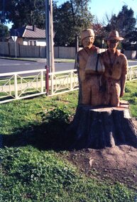
Photograph - Photograph Collection, Greensborough War Memorial Park Sculptures, 2003c
Sculptures created from stumps of trees planted around Greensborough War Memorial park. This collection is by an unknown photographer.Memorial to past armed services people from Greensborough District.Set of 8 photographs of chainsaw sculptures in Greensborough War Memorial Park.greensborough war memorial park, sculptures, ester street, leigh conkie, chainsaw sculptures, war memorials -
 National Wool Museum
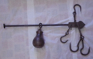
Steelyard
Steelyard used for weighing wool and wheat on "Moor Park" on Yarriariak Creek, twenty miles from Horsham, Victoria.Steelyard used for weighing wool and wheat on "Moor Park" on Yarriariak Creek.sheep stations management, wool growing, hamilton, mr robert g, sheep stations - management -
 Clunes Museum
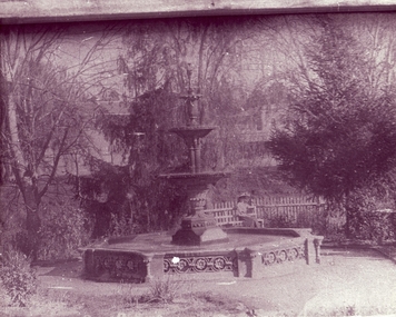
Photograph - PHOTOGRAPH QUEENS PARK
FOUNTAIN IN QUEEN'S PARK, CLUNES LADY SITTING ON GARDEN BENCH BESIDE PICKET FENCEBLACK AND WHITE PHOTOGRAPH OF FOUNTAIN IN QUEEN'S PARK, CLUNES. LADY SITTING ON BENCH.POSTCARD TO HELENA DAVIES, MARYFIELD 1909local history, photography, photographs, queen's park garden -
 Whitehorse Historical Society Inc.
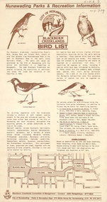
Pamphlet, Blackburn Creeklands Bird List, 1/07/1986
Blackburn Creeklands Bird List , City of Nunawading.Blackburn Creeklands Bird List , City of Nunawading, Nunawading Parks and Recreation information, July 1986.Blackburn Creeklands Bird List , City of Nunawading. city of nunawading. parks and recreation department., blackburn creeklands, birds, humphries, jon, susan, valentine, peter, zappe, hilda, beck, merlin -
 City of Ballarat
Artwork, other - Public Artwork, Joe Pratt et al, Hidden Waterway, 2016
To create 'Hidden waterway' (2016) Artist Forest Keegel held workshops with the people of Ballarat East who drew images in the park of threatened local fauna and waterbugs that once inhabited this land. Those images were then translated into carvings by sculptor Joe Pratt across 20 boulders creating a trail throughout the park. The artwork is of aesthetic and social significance to the people of Ballarat20 bluestone boulders with carvings across the surface creating a trail throughout the park forest keegel, joe pratt, ballarat east, pennyweight park -
 Flagstaff Hill Maritime Museum and Village
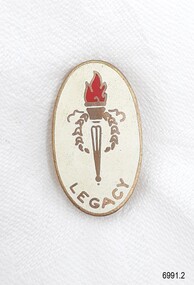
Badge - Legacy Appeal badge, A.J. Parkes, 1966
This Legacy badge is one of a set of badges collected by Dr W R Angus from the organisations in which he was involved. The badge was made by A.J. Parkes of Brisbane, an Australia-wide firm that has been making badges for over a century. The $2' and "£1" (one pound) embossed on the back dates the badge dates the badge to the year 1966 when Australian money was in the process of converting from pounds and pence to decimal currency's dollars and cents. It is interesting to note that the dollar sign "$2" has two vertical lines through the 'S', but the Australian currency sign for a dollar has only one vertical line. The badge may have been produced before the date of decimal conversion, which began on February 14th, 1966. A J Parkes may have ordered the badges before the published use of the dollar symbol. The set of badges is now part of Flagstaff Hill’s comprehensive W.R. Angus Collection, donated by the family of Dr W R Angus, surgeon and oculist. The W.R. Angus Collection: - The W.R. Angus Collection includes historical medical equipment, surgical instruments and material belonging to Dr Edward Ryan and Dr Thomas Francis Ryan, (both of Nhill, Victoria) and Dr Angus’ own belongings. The Collection’s history spans the medical practices of the two Doctors Ryan, from 1885-1926 plus that of Dr Angus, up until 1969. It includes historical medical and surgical equipment and instruments from the doctors Edward and Thomas Ryan of Nhill, Victoria. Dr Angus married Gladys in 1927 at Ballarat, the nearest big city to Nhill where he began as a Medical Assistant. He was also Acting House surgeon at the Nhill hospital where their two daughters were born. During World War II He served as a Military Doctor in the Australian Defence Forces. Dr Angus and his family moved to Warrnambool in 1939, where Dr Angus operated his own medical practice. He later added the part-time Port Medical Officer responsibility and was the last person appointed to that position. Both Dr Angus and his wife were very involved in the local community, including the planning stages of the new Flagstaff Hill and the layout of the gardens there. Dr Angus passed away in March 1970.This badge is significant for connecting Doctor Angus to organisations that he supported. It is also historically significant for representing Australia's conversion to decimal currency. The W.R. Angus Collection is significant for still being located at the site it is connected with, Doctor Angus being the last Port Medical Officer in Warrnambool. The Collection includes historical medical objects that date back to the late 1800s.Legacy Appeal badge; an oval-shaped metal and enamel badge, white enamel on gold, with the Legacy symbol of a flaming torch in the centre. It has a vertical stick pin and inscriptions on the back. It was made by A.J. Parks, Brisbane. The badge was given to a donor of $2 (£1 or one pound) to Legacy. This badge is part of a set of badges collected by Dr W R Angus. the set represents organisations that he was involved in, and is part of the W.R. Angus Collection.Embossed: "PARIVETTE 77-“ "A J PARKES" "BRISBANE" "£1" (one pound) "$2” (2 dollars) flagstaff hill, warrnambool, maritime village, maritime museum, shipwreck coast, great ocean road, badge, legacy badge, organisation badge, a.j. parkes, donor's badge, £1 badge, $2 badge, 14th february 1966, australian decimal conversion, brisbane, legacy appeal, w.r. angus collection -
 Eltham District Historical Society Inc
Photograph - Black and White Print, Lewis Tulk, Yarra Batman Area Scout Stage III training at Meruka Park, Eltham, c.1980
Scout training course held at Meruka Park Donated by Lewis Tulk, former Scout Area Training Commisioner for Leaders.Inscribed on reverse: YBA Scout Stage III Meruka Park Elthamscouts victoria, scout leader training, lewis tulk collection, eltham, yarra batman area, meruka park -
 St Kilda Historical Society
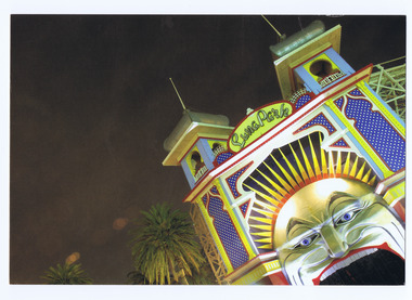
Postcard, Matt Irwin, Luna Park
Luna Eclipse, Luna Park, St Kilda, Melbournecolour postcard, unmounted, good conditionMatt Irwin picture card. Luna eclipse, Luna Park, St Kilda, Melbourne -
 Glenelg Shire Council Cultural Collection
Slide - Lantern Slides, n.d
Two glass lantern slides in cardboard box, both showing men at working bees (two different images) at Hanlon Park. Photo on one glass slide, then another plain glass slide fixed over image. Slides bound with white adhesive tape. Box has maker's label on front, label advising what to do if slides are fault, on bottom.Front: a) 'Some of the 'BUSY-BEES' HANLON PARK PORTLAND ' written in black pen, top of slide 'SOME OF THE 'BEES' HANLON PARK PORTLAND' scratched into slide, bottom. b) 'SOME OF THE 'BEES' HANLON PARK PORTLAND' -pen, top of slide 'THE BEES HANLON PARK PORTLAND TOYE PHOTO' scratched into slide, bottom -
 Northern District School of Nursing. Managed by Bendigo Historical Society Inc.
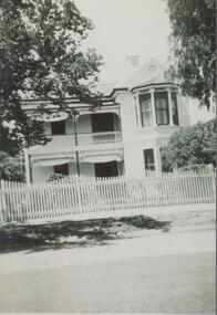
Photograph - Mayfort House
The Northern District School of Nursing opened in 1950 in to address the issues around nurse recruitment, training and education that had previously been hospital based. The residential school was to provide theoretical and in-house education and practical training over three years. The students would also receive practical hands-on training in the wards of associated hospitals. The Northern District School of Nursing operated from Lister House, Rowan Street, Bendigo. It was the first independent school of nursing in Victoria and continued until it closed in 1989.B&W photograph of Mayfort House, nurses' accommodation, 148 Wattle Street, Bendigo. Now demolished, site of present-day car park.Mayfort House, nurses' accommodation, 148 Wattle Street, Bendigo. Now demolished, site of present-day car park.ndsn, nursing -
 St Kilda Historical Society
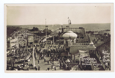
Photograph, Whitney Bros Electric Post Card Studio, Luna Park, c. 1900s
Luna Park with crowd milling, aerial view from the entrance towers, St Kilda bay behind.black and white image on front of postcard, unmounted, good conditionFront: Luna Park From The Entrance Towers; Whitney Bros. Photo 18; Back: Whitney Bros, Electric Post Card Studio, Luna Park, St kilda. Melbourne, Australia. -
 Wonga Park Community Cottage History Group
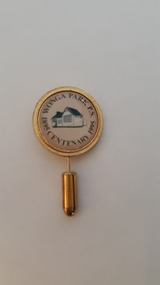
Tie Pin, Wonga Park Primary School Centenary 1895 - 1995, 1995
Item one of several made to commemorate Centenary of Wonga Park Primary School in 1995.Small gold coloured, stick format tie pin with circular emblem words around the outside and drawing in the centre denoting the occasion.Wonga Park P.S. Centenary 1895 - 199. stylized drawing of original school. -
 Halls Gap & Grampians Historical Society
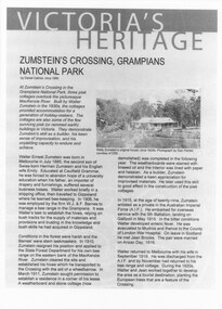
Document - Article (magazine/newspaper)
Article (3pages) written by David Catrice for Parks Victoria. More history on Walter Zumstein and the Zumstein area can be found on p137, 153 -156, 83, 107, 136 of "Victoria's Wonderland: a Grampians History"3page Article describes Walter Zumstein and the area known as 'Zumstein's'. Entitled Zumstein's Crossing, Grampians National Park from "Victoria's Heritage", Parks Victoria c1995media, magazine articles -
 Clunes Museum
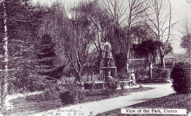
Photograph, QUEENS PARK, 1900 - 1910
.1 BLACK AND WHITE PHOTOGRAPH OF CLUNES QUEEN'S PARK. LADY SITTING ON FOUNTAIN EDGE. BUTTER FACTORY BRIDGE IN BACKGROUND. ELM TREES AND CYPRUS TREE AND PALM TREE PICTURED. .2.3 coloured enlarged copiesVIEW OF THE PARK, CLUNES. "SUNDAY" J.H.M. 6.2.10 SOH .1 about 1900-1905local history, queen's park garden -
 Surrey Hills Historical Society Collection
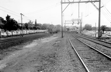
Photograph, Surrey Hills Station and car park
There are 3 tracks; the third track was built in 1971, which gives an approximate date for the photo. At this time the original station buildings were demolished and replaced by buildings constructed from concrete bricks and a second subway replaced the overhead footbridge. According to Roderick Smith, a local railway enthusiast, originally there had been 3 railway houses at the Mont Albert end of the northern car park. These were demolished to extend the car park. Certainly 8 Bedford Avenue, built as the station master's house was demolished at this time. The palm tree had been planted in the station master's front garden and was retained in a small garden bed within the car park. A black and white photograph of a station with cars parked on both sides of the 3 tracks. A Harris train is departing the station heading towards Mont Albert. A palm tree is prominent in the station car park to the north.1971, surrey hills station, railway stations, car parks, public transport, trains, railway lines, palm tree -
Friends of Ballarat Botanical Gardens History Group
Work on paper - List of Trees Grown in Victoria Park. VPRS, Box 109. 5/1/1916. To the Town Clerk from the Hospital for the Insane, 21 Different Trees grown in Victoria Park in the early twentieth century, Unknown
Victoria Park featured in Ballarat's history from the nineteenth century.Victoria Park is a significant recreation area in Ballarat although the Ballarat Botanical Gardens and Lake Wendouree appear to have been seen as the pre-eminent garden areas over the years. 1 page with a list of names and numbers beside each. Reference at the bottom of the page.Written in black biro, beside the list, "List of Trees Grown in Victoria Park,1915.john garner, doctor john garner, ballarat botanical gardens, victoria park, friends of ballarat botanical gardens, trees, world war 2, american troops, john garner collection, gardens, ballarat -
 Kew Historical Society Inc
Photograph - Civic event in Stradbroke Park, 1976
Stradbroke Park. Extent: Kilby Road to Harp Road at Burke Road. Historical Documentation: 1851 - Portion 91 purchased by Edward Glynn; 1888 - The Harp of Erin Estate (which included Section 91) offered for sale; 1896 - The area now known as Stradbroke Park was bisected by a creek that flowed from the Yarra via Hay's Paddock (q.v.) and extended through to Burke Road; 1943 - W.D. Birrell, Town Clerk of Kew, proposed that the creek be filled and a reserve created; 1954 - Entire area designated as 'open space' and named 'Stradbroke Park'. The line of the creek that ran through the Park created a further reserve on the north side of High Street, now known as 'Harrison Reserve'. Existing Condition: The park is largely of mown grass that has mature trees set into it It is possible that a number of these are remnant of the original vegetation, while there are also a number of exotic trees introduced, particularly at the northern end of the park. The southern end is dominated by playing fields. (Source: Sanderson, P 1988. Kew Conservation Study)Colour photographic positive (with colour degradation) of sporting teams at a civic event in Stradbroke Park in Kew East in May 1976. The event was officiated by the Mayor of Kew, Cr Alan Hutchinson. Stradbroke Park is situated on the western boundary of Kew and bordered by Burke and Harp Roads.stradbroke park, cr alan hutchinson, team sports -- kew (vic.) -
Whitehorse Historical Society Inc.
Photograph - Illustration, Mary Ann Jeffery, n.d
Photocopy of portrait of Mary Ann Jeffery, 1853 - 1943Photocopy of portrait of Mary Ann Jeffery, 1853 - 1943 (from 'Sevenoaks Park' by R. de Costa)Photocopy of portrait of Mary Ann Jeffery, 1853 - 1943jefferey, mary ann -
 Marysville & District Historical Society
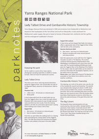
Flyer (item) - Information Flyer, Parks Victoria, park notes-Yarra Ranges National Park-Lady Talbot Drive and Cambarville Historic Township, June 2013
A flyer produced by Parks Victoria of information on Lady Talbot Drive and Cambarville Historic Township.A flyer produced by Parks Victoria of information on Lady Talbot Drive and Cambarville Historic Township. Lady Talbot Drive a 24 kilometer scenic rainforest car journey which passes a number of walks and waterfalls in the Yarra Ranges National Park. Lady Talbot Drive is named after Lady Sarah Elizabeth, the wife of Sir Reginald Talbot, who was the Governor of Victoria from 25th April, 1904 to 6th July 1908. Cambarville is notable for its giant mountain ash (Eucalyptus regnans) trees within the Cumberland Memorial Scenic Reserve, and relics from former sawmills and gold mining. The Big Culvert is located nearby on the Marysville-Woods Point Road, which was historically part of the Yarra Track. Cambarville was established as a timber mill town in the 1940s. Timber mill owners A Cameron and FJ Barton named Cambarville. They established the mill to salvage timber from trees destroyed in the 1939 bushfires. Cambarville was impacted by the 2009 Black Saturday bushfires and any remaining structures were destroyed. parks victoria, yarra ranges national park, lady talbot drive, lady talbot forest drive, cambarville, taggerty river, sir reginald talbot, lady sarah elizabeth talbot, phantom falls, keppel falls, keppel falls lookout, beeches rainforest walk, big culvert, cumberland walk, the big tree, the sitka spruce, cora lynn falls, sovereign view -
 National Wool Museum
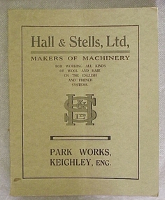
Book, Hall & Stells, Ltd, Makers of Machinery
"Hall & Stells, Ltd, Makers of Machinery, Park Works, Keighley, Eng", catalogue of machinery."Hall & Stells, Ltd, Makers of Machinery, Park Works, Keighley, Eng", catalogue of machinery.textile machinery, hall and stells limited -
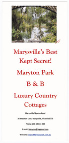 Marysville & District Historical Society
Flyer (item) - Information flyer, Marysville's Best Kept Secret! Maryton Park B&B Luxury Country Cottages, Unknown
An information flyer regarding Maryton Park B&B Country Cottages near Marysville.An information flyer regarding Maryton Park B&B Country Cottages near Marysville.marysville, victoria, australia, maryton park b&b country cottages, accommodation, information flyer -
 Marysville & District Historical Society
Flyer (item) - Information flyer, Maryton Park B&B Country Cottages, Unknown
An information flyer regarding Maryton Park B&B Country Cottages near Marysville.An information flyer regarding Maryton Park B&B Country Cottages near Marysville.marysville, victoria, australia, maryton park, maryton park b&b country cottages, accommodation, information flyer -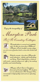
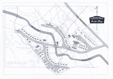 Marysville & District Historical Society
Map (Item) - Marysville Caravan Park map, Marysville CARAVAN PARK-Park Map, Unknown
A map of the Marysville Caravan Park showing the location of the various sites and facilities available to guests.A map of the Marysville Caravan Park showing the location of the various sites and facilities available to guests.marysville, victoria, australia, marysville caravan park, map -
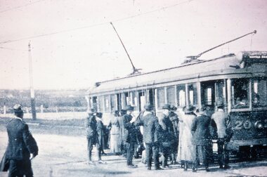 Melbourne Tram Museum
Slide - Black and white reproduction photograph - HTT Wattle Park line c1917
Photograph - HTT Wattle Park line c1917, bogie tram 20 loading many passengers. The tram is showing the destination of Wattle Park. Open fields in the background. Appears to be at least one solider waiting to board the tram.Yields information about the Wattle Park line and the trams used.Kodachrome cardboard duplicate slide - Black and white reproduction photograph - HTT Wattle Park line c1917 "MP8" in penciltrams, tramways, opening, htt, hawthorn tramways trust, wattle park, tram 20 -
 Stawell Historical Society Inc
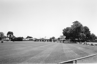
Photograph, Central Park Oval looking towards scoreboard and athletic club rooms
Central Park looking towards scoreboard (left) and athletic club roomsCentral Park oval looking towards the scoreboard on the left and Athletic Club rooms. c 1999 -
 Kew Historical Society Inc
Photograph - Flooding in the Willsmere Park, 1993
Willsmere Park is bounded by the the Yarra River, Green Acres Golf Club, Willow Grove and the Eastern Freeway. The land on which the park is now situated was bought by Thomas Wills at the Crown Land Sales of 1846 (Section 56). From the 1840s to the 1940s it was intensively farmed. The park is dominated by very large playing fields, while planting to the southern boundary was undertaken when the Eastern Freeway was built. It is only along the banks of the Yarra that there is any remnant native vegetation. Willsmere Park is of significance as an area of open land that remains from the flood plain that once dominated northern Kew. (Source: Kew Conservation Study, 1988)Original colour small format polaroid photograph of flooding in the Willsmere Park, taken on 16 September 1993."Flooding of shared path from Willsmere Billabong 16.9.93"willsmere park, yarra river -- floods -- kew (vic.), kew billabong -
 Kew Historical Society Inc
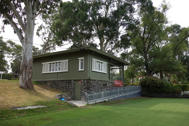
Photograph - Digital Photograph, Robert Baker, Kew Croquet Club, Victoria Park (Kew), 2014
The Kew Croquet Club rooms were designed by Roland Chipperfield. The Club was founded in 1934 and is located in Victoria Park, Kew.Born digital image of the exterior of the Kew Croquet Club in Victoria Park, Kew.kew croquet club - kew (vic), sports -- kew (vic.)