Showing 10387 items
matching plan
-
 Ringwood and District Historical Society
Cartons stored off-site, Carton Awaiting cataloguing:labelled Library plans and folders with misc. research
Carton labelled Library plans and folders with misc research -
Ringwood and District Historical Society
Envelope, Estate Agents - various plans and notes of Ringwood Subdivision
Estate Agents - various plans of Subdivision; Notes on Subdivisions -
Federation University Historical Collection
Report, Ballarat School of Mines Report on Training for Caravan Park Managers, 1979, 02/1979
Ballarat School of Mines report . Planning Document 5.79ballarat school of mines, planning document, tafe, caravan park managers, j.l. turner, tourism -
 City of Moorabbin Historical Society (Operating the Box Cottage Museum)
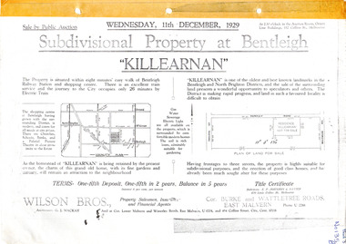
Flyer - Killearnan Estate, McKinnon, 1929
The train line from the city to Frankston was electrified in 1922 which intensified the sale in the municipality of Moorabbin, particularly land which was in the vicinity of the railway stations.Example of the progress of the Municipality of MoorabbinSubdivisional plan and advertisements for the sale of "Killearnan" Estate, Bentleigh "Killearnan" Estate, Bentleigh - Auction 11 December 1929thomas street, yawla street, huntley road, whitmuir road, mckinnon, bentleigh, real estate, auction -
Port Melbourne Historical & Preservation Society
Archive - Heritage History Festival, 1990 - 1991
File 09 - Heritage History Festival, displays, planninglocal government - city of port melbourne, built environment, families, celebrations fetes and exhibitions, domestic life, industry, recreation, sport, pat grainger, jill dawson, wendy morris, vintage port - worth preserving project 1991 -
Port Melbourne Historical & Preservation Society
Map - Williamstown, MMBW, 17 Jul 1894
Melbourne and Metropolitan Board of Works Plan for Williamstown, 1894.Signed W. Thwaites.melbourne and metropolitan board of works, mmbw, williamstown, william thwaites -
 Monbulk RSL Sub Branch
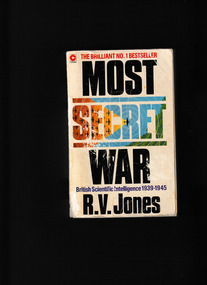
Book, Coronet, Most secret war, 1979
Reginald Jones was nothing less than a genius. And his appointment to the Intelligence Section of Britain's Air Ministry in 1939 led to some of the most astonishing scientific and technological breakthroughs of the Second World War. In Most Secret War he details how Britain stealthily stole the war from under the Germans' noses by outsmarting their intelligence at every turn. He tells of the 'battle of the beams'; detecting and defeating flying bombs; using chaff to confuse radar; and many other ingenious ideas and devices. Jones was the man with the plan to save Britain and his story makes for riveting reading.Index, notes, ill, maps, plans, p.702.non-fictionReginald Jones was nothing less than a genius. And his appointment to the Intelligence Section of Britain's Air Ministry in 1939 led to some of the most astonishing scientific and technological breakthroughs of the Second World War. In Most Secret War he details how Britain stealthily stole the war from under the Germans' noses by outsmarting their intelligence at every turn. He tells of the 'battle of the beams'; detecting and defeating flying bombs; using chaff to confuse radar; and many other ingenious ideas and devices. Jones was the man with the plan to save Britain and his story makes for riveting reading. world war 1939 – 1945 – secret service – britain, world war 1939 – 1945 – science and technology -
Bendigo Historical Society Inc.
Document - GREATER CITY OF BENDIGO DRAFT STRATEGY PLANS
DVD, Greater City of Bendigo Draft Strategy Plans, -
Bendigo Historical Society Inc.
Archive - HUSTLERS REEF RESERVE CONSERVATION MANAGEMENT PLAN
DVD. HUSTLERS REEF RESERVE CONSERVATION MANAGEMENT PLAN. -
 Bendigo Historical Society Inc.
Map - JACK FLYNN COLLECTION: SALISBURY, 1965
Map: Parish of Salisbury, County of Bendigo. Parish plan.By Authority A. C. Brooks Government Printer, Melbourne. Drawn and Reproduced at the Department of Lands and Survey, Melbourne.map, bendigo, parish plan, salisbury -
 Bendigo Historical Society Inc.
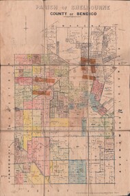
Map - JACK FLYNN COLLECTION: SHELBOURNE, 11/02/1937
Map: Parish of Shelbourne, County of Bendigo. Parish plan.By Authority, H. J.Green, Government Printer. Drawn and Reproduced at the Dept, of Lands and Survey, Melbourne, Victoria.map, bendigo, parish plan, shelbourne -
 Bendigo Historical Society Inc.
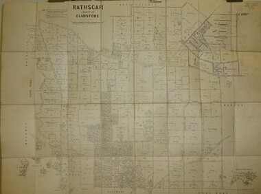
Map - JACK FLYNN COLLECTION: RATHSCAR, 14/09/1935
Map: Parish of Rathscar, County of Gladstone. Parish plan.map, gladstone, parish plan, rathscar -
 Bendigo Historical Society Inc.
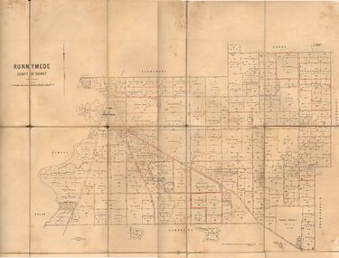
Map - JACK FLYNN COLLECTION: RUNNYMEDE, June 1946
Map: Parish of Runnymede, County of Rodney. Parish plan.By Authority: J.J. Goourley, Government Printer, Melbourne. Drawn and Reproduced at the Lands and Servey, Melbourne, Victoria. June, 1946.map, rodney, parish plan, runnymede -
 Bendigo Historical Society Inc.
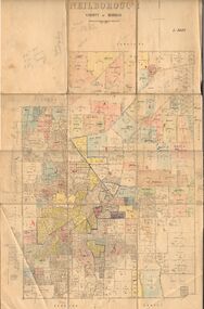
Map - JACK FLYNN COLLECTION: NEILBOROUGH, 13/10/1927
Map: Parish of Neilborough, County of Bendigo. Parish plan.Photo Lithographed at the Department of Lands and Survey, Melbourne by W.J. Butsonmap, bendigo, parish plan, neilborough -
 Bendigo Historical Society Inc.
Map - JACK FLYNN COLLECTION: MUSKERRY, 1962
Map: Parish of Muskerry, County of Rodney. Parish plan.By Authority: A.C. Brooks, Government Printer, Melbourne. Drawn and reproduced at the Department of Lands and Survey, Melbournemap, rodney, parish plan, muskerry -
 Bendigo Historical Society Inc.
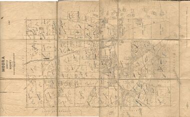
Map - JACK FLYNN COLLECTION: MOORA, 9/10/22
Map: Parish of Moora, County of Rodney. Parish plan.By Authority A.J. Mullet Government Printer Melbourne. Photo Lithographed at the Dept, of Lands and Survey, Melbourne by W.J. Butson. 3.10.22map, rodney, parish plan, moora -
 Bendigo Historical Society Inc.
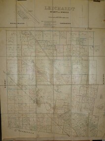
Map - JACK FLYNN COLLECTION: LEICHARDT, 14/03/1`939
Map: Parish of Leichardt, County of Bendigo. Parish plan.Drawn and Reproduced at the Dept, of Lands and Survey, Melbourne, Victoria. 14.3.1939map, bendigo, parish plan, leichardt -
 Bendigo Historical Society Inc.
Map - JACK FLYNN COLLECTION: HAYANMI, March 1953
Map: Parish of Hayanmi, County of Bendigo. Parish plan.By Authority: W.M. Houston, Government Printer. Drawn and reproduced at the Dept, of Lands and Survey, Melbourne, Victoriamap, bendigo, parish plan, hayanmi -
 Bendigo Historical Society Inc.
Map - JACK FLYNN COLLECTION: HUNTLY, 8/09/1921
Map: Parish of Huntly, County of Bendigo. Parish plan.By Authority, Govt., Printer. A. J. Mullett. Photo Lithographed at the Department of Land and Survey Melbourne By W. J. Butsonmap, bendigo, parish plan, huntly -
 Bendigo Historical Society Inc.
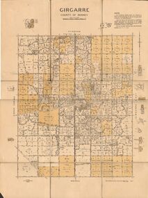
Map - JACK FLYNN COLLECTION: GIRGARRE, 14/10/1943
Map: Parish of Girgarre. County of Rodney. Parish plan.By Authority, H.E. Daw, Government Printer Melbourne. Drawn and produced at the Dept of Lands and Survey, Melbourne, Victoria. 14.10.1943map, rodney, parish plan, girgarre, county of rodney -
 Bendigo Historical Society Inc.
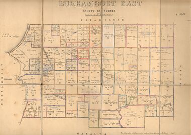
Map - JACK FLYNN COLLECTION: BURRUMBOOT EAST, 21/12/1027
Map: Burrumboot East, County of Rodney. Parish plan.Photo Lithographed at the Department of Lands and Survey, Melbourne by W.J.Butson. 21.12.27map, rodney, parish plan, burrumboot east -
 Bendigo Historical Society Inc.
Map - JACK FLYNN COLLECTION: ECHUCA NORTH, November 1953
Map: Echuca North, County of Rodney. Parish plan.By Authority: W.M. Houston, Government Printer. Drawn and Reproduced at the Dept., of Lands and Survey Melbourne, Victoria. November 1953map, rodney, parish plan, echuca north rodney -
 Bendigo Historical Society Inc.
Map - JACK FLYNN COLLECTION: BURNEWANG, 17/09/1918
Map: Parish of Burnewang, County of Rodney. Parish plan.By Authority, H. J. Green, Acting Government Printer Melbourne. Photo Lithographed at the Department of Lands and Survey, Melbourne by W. J. Butson.map, rodney, parish plan, burnewang, rodney -
 Bendigo Historical Society Inc.
Map - JACK FLYNN COLLECTION: BONN, 16/07/1919
Map: Parish of Bonn, County of Rodney. Parish plan.By Authority A. J. Mullett. Government Printer, Melbourne. Photo Lithographed at the Department of Lands and Survey. Melbourne by W. J. Butson.map, rodney, parish plan, bonn, rodney -
 Bendigo Historical Society Inc.
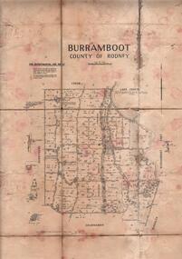
Map - JACK FLYNN COLLECTION: BURRUMBOOT, August 1951
Map: Parish of Burrumboot, County of Rodney. Parish plan.By Authority J.J. Gourley, Government Printer Melbourne. Drawn and Reproduced at the Dept of Lands and Survey, Melbourne, Victoria. August 1951map, rodney, parish plan, burrumboot, rodney -
 Bendigo Historical Society Inc.
Map - JACK FLYNN COLLECTION: BEALIBA, 15/09/1931
Map: Parish of Bealiba, County of Gladstone. Parish plan.By Authority H.J. Green, Government Printer. Photo Lithographed at the Government of Lands and Survey Melbourne. 15.9.31map, gladstone, parish plan, bealiba, gladstone -
 Bendigo Historical Society Inc.
Map - JACK FLYNN COLLECTION: BAMAWM, 19/08/1924
Map: Parish of Bamawm, County of Bendigo. Parish plan.Photo Lithographed at the Department of Lands and Survey, Melbourne by W.J. Butson. 19.8.24map, bendigo, parish plan, bamawm -
 Bendigo Historical Society Inc.
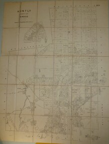
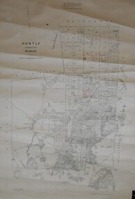
Map - JACK FLYNN COLLECTION: HUNTLY, August 1954
Map: Parish of Huntly, County of Bendigo. Parish plan.By Authority W.M. Houston, Government Printer. Drawn and Reproduced at the Dept, of Lands and Survey, Melbourne, Victoria. August 1954.map, bendigo, parish plan, huntly -
 Bendigo Historical Society Inc.
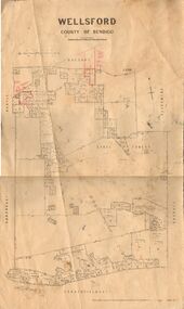
Map - JACK FLYNN COLLECTION: WELLSFORD, 2/11/1914
Map: Parish of Wellsford, County of Bendigo. Parish plan.Photo-Lithographed at the Department of Lands and Survey Melbourne By H.J. Butson. 2-.11.14map, bendigo, parish plan, wellsford -
 Bendigo Historical Society Inc.
Map - JACK FLYNN COLLECTION: YARRAYNE, 6/01/1932
Map: Parish of Yarrayne, County of Bendigo. Parish plan.By Authority, H.J. Green, Govt., Printer. Photo-Lithographed at the Department of Lands and Survey, Melbourne. 5.1.32.map, bendigo, parish plan, yarrayne