Showing 13592 items
matching wye-river-bridge
-
 Eltham District Historical Society Inc
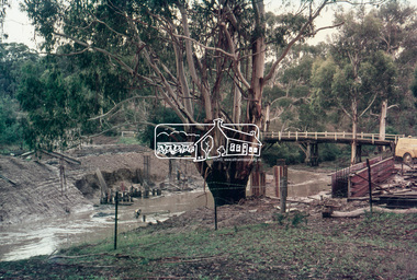
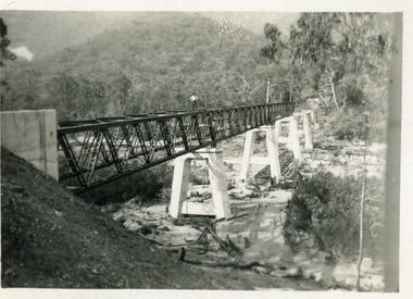
Slide, Construction of new bridge, looking downstream from west bank towards existing Lintons Bridge across Arthurs Creek, Doctors Gully Road, Nutfield, 22 February 1972, 1972
35 mm colour positive transparency Mount - Agfacolor Service (Blue)arthurs creek, bridge construction, doctors gully road, eltham shire council, infrastructure, lintons bridge, nutfield -
 Eltham District Historical Society Inc
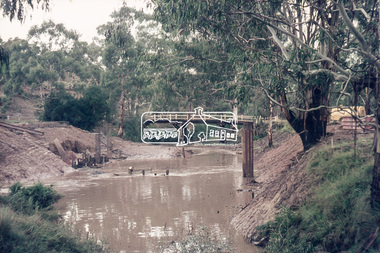
Slide, Construction of new bridge, looking downstream from west bank towards existing Lintons Bridge across Arthurs Creek, Doctors Gully Road, Nutfield, 22 February 1972, 1972
35 mm colour positive transparency Mount - Agfacolor Service (Blue)arthurs creek, bridge construction, doctors gully road, eltham shire council, infrastructure, lintons bridge, nutfield -
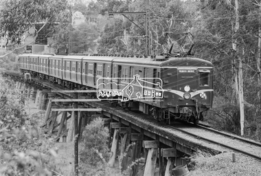
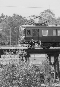
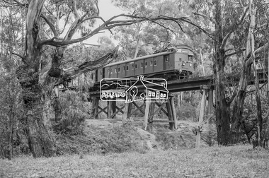
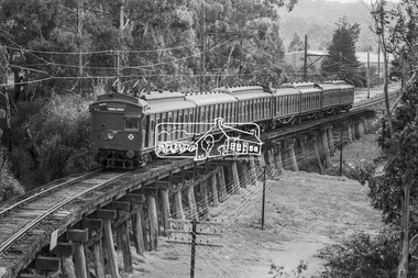
 Eltham District Historical Society Inc
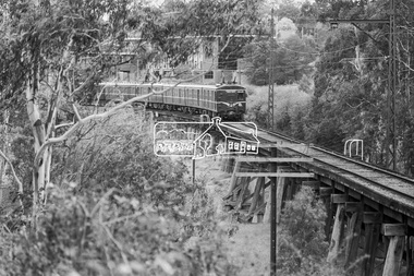
Photograph, George Coop, Princes Bridge bound Harris (Blue) train crossing the Eltham Railway Trestle Bridge, March 1980, 1980
Former Eltham Shire Council offices in backgroundDigital TIFF file Scan of 35mm Kodak Safety 5063 black and white transparencyeltham shire office, eltham trestle bridge, harris (blue) train, princes bridge railway station -
 Eltham District Historical Society Inc
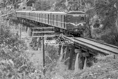
Photograph, George Coop, Princes Bridge bound Harris (Blue) train crossing the Eltham Railway Trestle Bridge, March 1980, 1980
Former Eltham Shire Council offices in backgroundDigital TIFF file Scan of 35mm Kodak Safety 5063 black and white transparencyeltham shire office, eltham trestle bridge, harris (blue) train, princes bridge railway station -
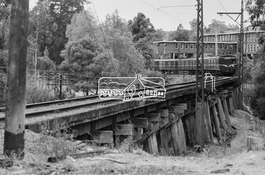
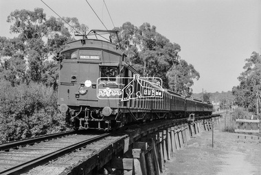
 Eltham District Historical Society Inc
Photograph, George Coop, Eltham bound Harris (Blue) train from Princes Bridge crossing the Eltham Railway Trestle Bridge, March 1980, 1980
Former Eltham Shire Council offices in backgroundDigital TIFF file Scan of 35mm Kodak Safety 5063 black and white transparencyeltham shire office, eltham trestle bridge, harris (blue) train, princes bridge railway station -
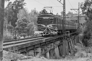
 Eltham District Historical Society Inc
Photograph, George Coop, Princes Bridge bound Harris (Blue) train crossing the Eltham Railway Trestle Bridge, March 1980, 1980
Former Eltham Shire Council offices in backgroundDigital TIFF file Scan of 35mm Kodak Safety 5063 black and white transparencyeltham shire office, eltham trestle bridge, harris (blue) train, princes bridge railway station -
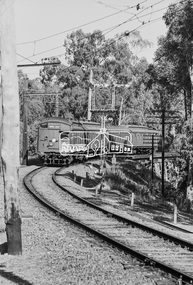
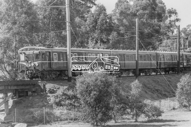 Eltham District Historical Society Inc
Photograph, George Coop, A Harris (Blue) train bound for Princes Bridge crossing the Eltham Railway Trestle Bridge at Panther Place, c.1980, 1980
Digital TIFF file Scan of 9 x 13 cm black and white print747m, eltham trestle bridge, harris (blue) train, panther place -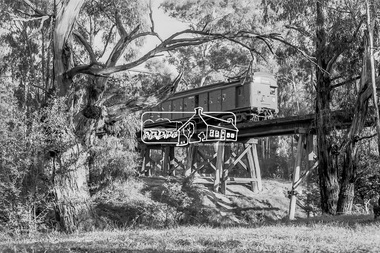
 Eltham District Historical Society Inc
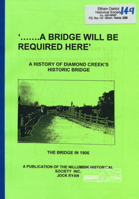
Book, Nillumbik Historical Society, '.......A Bridge Will Be Required Here': A history of Diamond Creek's historic bridge by Jock Ryan, 2005
7 pages, mapsdiamond creek, bridge -
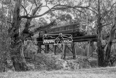
 Eltham District Historical Society Inc
Photograph, George Coop, A Tait (Red Rattler) train bound for Princes Bridge commences crossing the Eltham Railway Trestle Bridge, c.1981, 1981
Digital TIFF file Scan of 35mm Ilford FP4 black and white transparencyeltham trestle bridge, red rattler, tait train -
 Eltham District Historical Society Inc
Photograph, George Coop, A Harris (Blue) train bound for Princes Bridge crosses the Eltham Railway Trestle Bridge, c.1981, 1981
Digital TIFF file Scan of 35mm Ilford FP4 black and white transparencyeltham trestle bridge, harris (blue) train -
 Eltham District Historical Society Inc
Photograph, George Coop, A Tait (Red Rattler) train bound for Princes Bridge crosses the Eltham Railway Trestle Bridge, c.1981, 1981
Digital TIFF file Scan of 35mm Ilford FP4 black and white transparencyeltham trestle bridge, red rattler, tait train -
 Eltham District Historical Society Inc
Photograph, George Coop, A Tait (Red Rattler) train bound for Princes Bridge crosses the Eltham Railway Trestle Bridge, c.1981, 1981
Digital TIFF file Scan of 35mm Ilford FP4 black and white transparencyeltham trestle bridge, red rattler, tait train -
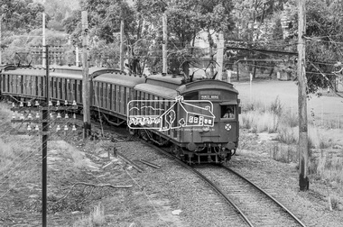 Eltham District Historical Society Inc
Photograph, George Coop, A Princes Bridge bound Tait (Red Rattler) train approaching the Eltham Railway Trestle Bridge, 7-8 February 1981, 1981
Digital TIFF file Scan of 35mm Ilford FP4 black and white transparencyred rattler, tait train -
 Eltham District Historical Society Inc
Photograph, George Coop, A Princes Bridge bound Tait (Red Rattler) train crossing the Eltham Railway Trestle Bridge, 7-8 February 1981, 1981
Digital TIFF file Scan of 35mm Ilford FP4 black and white transparencyeltham trestle bridge,red rattler, tait train -
 Eltham District Historical Society Inc
Photograph, George Coop, A Princes Bridge bound Tait (Red Rattler) train crossing the Eltham Railway Trestle Bridge, 7-8 February 1981, 1981
Digital TIFF file Scan of 35mm Ilford FP4 black and white transparencyeltham trestle bridge,red rattler, tait train -
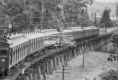
 Eltham District Historical Society Inc
Photograph, George Coop, A Princes Bridge bound Tait (Red Rattler) train crossing the Eltham Railway Trestle Bridge, 7-8 February 1981, 1981
Digital TIFF file Scan of 35mm Ilford FP4 black and white transparencyeltham trestle bridge, hurstbridge line, red rattler, tait train -
 Stawell Historical Society Inc
Archive, Dadswells Bridge Airgraph Letter 1943 to Jean & Bill Howard who was based in London a School Teacher at Ledcourt and Dadswells Bridge and, 1943
Aerogramglenorchy -
 Ringwood and District Historical Society
Photograph, Maroondah Highway West, Ringwood- 1965. Wantirna Road bridge, widening of bridge
Black and white photograph -
Tatura Irrigation & Wartime Camps Museum
Book, Wooden Wonders, 2006
To preserve the history of Victoria's wooden bridges. Local bridges were in danger of disappearing. To appreciate the wonder of native timber, a marvellous construction material that can save the planetPicture of 3 tier wooden bridge on front cover. Sepia postcard scenes of rail bridges on back.wooden wonders, timber bridges, chambers d, national trust, wooden bridges of victoria, history of wooden bridges in victoria -
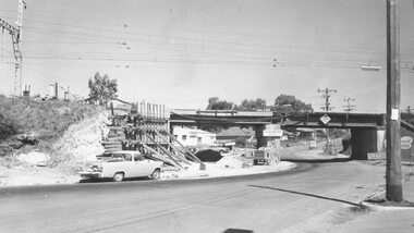
![Photograph - Construction of the F19 [Eastern Freeway], Ron Setford, October 1973](/media/collectors/550653872162f11fb04854aa/items/6808c3e9025de50d1e73220c/item-media/6808c404025de50d1e7324ef/item-fit-380x285.jpg) Kew Historical Society Inc
Kew Historical Society IncPhotograph - Construction of the F19 [Eastern Freeway], Ron Setford, October 1973
Ron Setford and his wife Grace Setford lived in Tanner Avenue, East Kew, from c.1946 to c.1995. A keen photographer, he recorded the changing face of Kew over a 20 year period. Apart from 30 photographs of built structures and places in Kew dating from 1960 and 1961, 145 of his 35mm colour slides chronicle the development of the F19 (later renamed Eastern) Freeway through the Yarra Valley in Kew over a five year period from c.1972 to c.1977. This important collection was donated to the Society by his granddaughter in 2025.This collection of 175 35mm slides is of local and statewide significance, owing to its subject matter, particularly the major development of road transport infrastructure during the 1970s with the construction of the Eastern Freeway. The photographer also took care to annotate and date most of his slides which enable the researcher to pinpoint temporal and spatial locations."Eastern Freeway / Chandler H/way to Fairfield / River Bridge Oct 73"ron setford, eastern freeway, f19 freeway -
 Federation University Historical Collection
Map - Geological, Tallangatta, New South Wales: 1:250,000 Geological Series, SJ 55-3, 1966, 1966
Compiled by the Geological Survey of N.S.W., Division of Regional Geology. Topographical base compiled from Snowy Mountains Hydro Electrical Authority, Department of Lands, County maps and Snowy Lease Map. Other sheet adjoin this map. There are 13 formation sections grouped into 9 - Quaternary, Tertiary, Middle Devonian, Lower to Middle Devonian, Lower Devonian, Upper Silurian, Silurian, Upper Ordovician and Ordovician.Large coloured map showing geological features, faults, bores, rivers and mineral deposits.Scale of map, longitude and latitude, river names. "Tallangatta 1:250,00" written in black pen.tallangatta, new south wales, geological survey, topographical base, snowy mountains hydro electrical authority, department of lands, snowy lease map, department of mines, quaternary, tertiary, middle devonian, lower to middle devonian, lower devonian, uper siluran, silurian, upper ordovician, ordovician -
 Hume City Civic Collection
Photograph
A black and white photograph of a bluestone arched bridge over Jackson Creek in Macedon Street. Taken at Easter 1934.on back: written in pen; Bridge @ Sunbury / Easter 1934cullinan, uraina, eileen, sunbury, jackson creek, macedon street, bulla, bridges, bluestone bridge, 1930s, george evans collection -
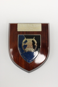 National Vietnam Veterans Museum (NVVM)
Plaque - Presented plaque
One of several items donated in memory of Sergeant Trevor J Nicholson, who served in Royal Australian Armoured Corps, C Squadron and B Squadron 1st Armoured Regiment, 1969-70, Vietnam.A wooden plaque with black, blue and gold shield shaped insignia of 12/16 Hunter River Lancers depicting an elephant and crossed banners and dedication.To WO2 Trevor Nicholson/From P.M.C and Members/12/16 HRL/Sergeants Mess 18.8.1993 Hunter River Lancers/12/16 Hunter River Lancers12/16 hunter river lancers, 4410261 wo2 trevor nicholson., trevor nicholson, 1st armoured regiment, nicholson, shield -
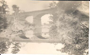
 Kew Historical Society Inc
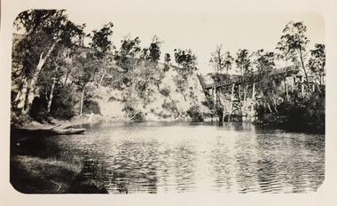
Photograph - Zig-Zag Bridge, 1924
Henry Beater Christian (1886-1962) , was a descendant of one of the earliest settler families in Kew. Employed at the Kew Asylum as a 'public servant', he was a skilled amateur photographer, photographing numerous scenes in Kew and on his travels around Victoria. The majority of his photographs date from 1916 to 1929. His finest photographs are housed in two photograph albums. Digital copy of a photograph from page 8 of the 47-page photograph album containing 261 gelatinous silver images, loaned by Diane Washfold with permission given to digitise and hold a copy in our collection. This photograph reveals how the photographer, Henry Christian, positioned himself to take the photograph from the angle in which he was interested. A skilled canoeist, an empty canoe is on the left of the photo that he apparently he used to access his vantage point. His subject, the Zig-Zag Bridge linked the grounds of the Yarra Bend and Kew Asylums. The wooden bridge was constructed in the 1870s and lasted through numerous floods until its destruction in 1929. A horizontal structure, one climbed steps to reach the higher Yarra Bend bank. At the Studley Park end, the bridge descended via a staircase to reach the much lower bank. "Zig-Zag Bridge"henry beater christian (1886-1962), landscape photography, kew (vic.) — yarra river, christian-washfold collection, photograph albums, zig-zag bridge -
 Kew Historical Society Inc
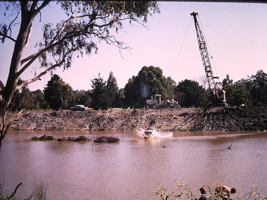
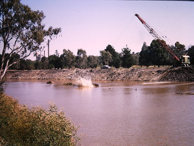
Photograph - Construction of the Eastern Freeway (F19), Ron Setford, March 1972
Ron Setford and his wife Grace Setford lived in Tanner Avenue, East Kew, from c.1946 to c.1995. A keen photographer, he recorded the changing face of Kew over a 20 year period. Apart from 30 photographs of built structures and places in Kew dating from 1960 and 1961, 145 of his 35mm colour slides chronicle the development of the F19 (later renamed Eastern) Freeway through the Yarra Valley in Kew over a five year period from c.1972 to c.1977. This important collection was donated to the Society by his granddaughter in 2025.This collection of 175 35mm slides is of local and statewide significance, owing to its subject matter, particularly the major development of road transport infrastructure during the 1970s with the construction of the Eastern Freeway. The photographer also took care to annotate and date most of his slides which enable the researcher to pinpoint temporal and spatial locations.Photograph of works involved in construction of the F19 (now Eastern) Freeway. The photo shows works to divert the route of the Yarra River in Kew in order to construct a section of the F19 Freeway. "Eastern Freeway / River diversion works / Mar 72"ron setford, eastern freeway, f19 freeway -
 Kew Historical Society Inc
Photograph - Construction of the Eastern Freeway (F19), Ron Setford, March 1972
Ron Setford and his wife Grace Setford lived in Tanner Avenue, East Kew, from c.1946 to c.1995. A keen photographer, he recorded the changing face of Kew over a 20 year period. Apart from 30 photographs of built structures and places in Kew dating from 1960 and 1961, 145 of his 35mm colour slides chronicle the development of the F19 (later renamed Eastern) Freeway through the Yarra Valley in Kew over a five year period from c.1972 to c.1977. This important collection was donated to the Society by his granddaughter in 2025.This collection of 175 35mm slides is of local and statewide significance, owing to its subject matter, particularly the major development of road transport infrastructure during the 1970s with the construction of the Eastern Freeway. The photographer also took care to annotate and date most of his slides which enable the researcher to pinpoint temporal and spatial locations.Photograph of works involved in construction of the F19 (now Eastern) Freeway. The photo shows works to divert the route of the Yarra River in Kew in order to construct a section of the F19 Freeway. "Eastern Freeway / River diversion works / Mar 72"ron setford, eastern freeway, f19 freeway -
 Lakes Entrance Historical Society
Photograph - Bridges, 1990
Also another photo taken laterColour photograph showing McKillops Bridge across the Snowy River in the High Country near Deddick, East Gippsland near the Victorian / NSW border, south side of bridge, road to Deddick just visible opposite end, taken from west end of bridge. River flowing to right, bridge of timber, steel and concrete, mountains around. East Gippsland Victoriabridges, waterways, topography -
 Lakes Entrance Historical Society
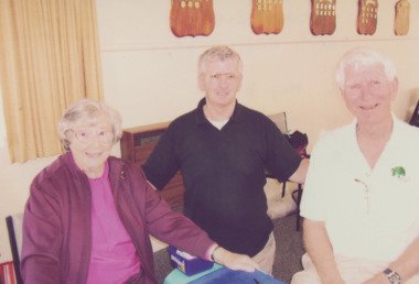
Photograph - Bridge players, Lakes Entrance Victoria, East Gippsland Newspaper, 1/10/2005 12:00:00 AM
Bridge players Kay Bignell Vic Burton and John Matthews at a Charity Bridge game Lakes Entrance VictoriaColour photograph of Bridge players Kay Bignell Vic Burton and John Matthews at a Charity Bridge game Lakes Entrance Victoriacelebrations, clubs, recreation