Showing 8497 items
matching snowy-river-dry-cleaners
-
 Lakes Entrance Historical Society
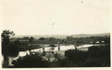
Photograph - Bridges, 1924
February 1924 date made.Black and white photograph of the railway bridge over the Tambo River at Bruthen, Victoria.bridges, waterways -
 Lakes Entrance Historical Society
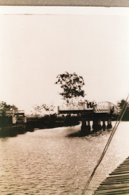
Photograph, 1925
Sepia photograph showing swing bridge open, on Latrobe River, at Longford, Victoriabridges, waterways -
 Lakes Entrance Historical Society
Book, Jones, Colin, Lakes Passenger Vessels, 2012
A study of passenger vessels on the Gippsland Lakes and rivers, from about 1880 to 2010ships and shipping -
 Lakes Entrance Historical Society
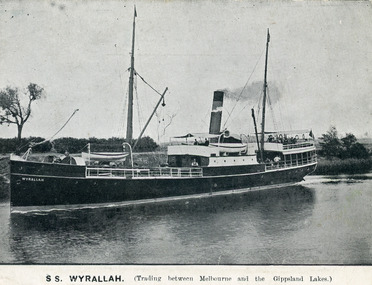
Postcard - SS Wyrallah, 1905
One other sepia copy same. One other copy in spare boxBlack and white postcard showing SS Wyralla in Mitchell River Bairnsdale Victoria.Advertisement on back. S.S. Wyralla Trading between Melbourne and the Gippsland Lakes on frontwaterways, ships and shipping, trade -
 Lakes Entrance Historical Society
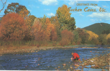
Postcard - autumn foliage at Buchan Victoria, Rose Series, 1960 c
Colour postcard of shallow river and trees showing autumn foliage at Buchan VictoriaGreetings from Buchan Caves Victopography, trees, rivers -
Clunes Museum
Postcard, HOLMFIRTH
ON THE CARD, A PRETTY SCENE NEXT TO A RIVER WITH WATER LILLIES AND A LADY PICKING FLOWERSlocal history, postcards -
Lakes Entrance Historical Society
Book, Ronald Parsons, A Pioneer Australian Steamship Company, 1990
A history of the Hunters River S N Co, and the Australian Steam Navigation Company.ships and shipping, maritime history -
Lakes Entrance Historical Society
Photograph - PS Tanjil, 1880 c
PS Tanjil was burnt to the waterline in February 1885Black and white photograph of the first PS Tanjil in the Mitchell Rivers Bairnsdale Victoriaboats and boating, waterways -
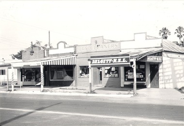 Wodonga & District Historical Society Inc
Photograph - Mann Collection Album - DALGETY N.Z.L, High Street West - corner of Melbourne Road to Railway, C. 1960s
Elaine Mann was married to David Mann, a successful Wodonga businessman and community leader who passed away in Wodonga in June 2012. David was a member of the Mann family who began their business in Wodonga in 1920. Elaine was a teacher in Wodonga for many years and an active member of the community.This photo collection is of significance as it documents how the businesses and buildings in Wodonga have evolved and contributed to community throughout the late 20th century.Dalgety-N.Z.L in High Street West - corner of Melbourne Road to the railway line. Businesses include a barber, dry cleaners and Dalgety-N.Z.L. Dalgety and Company Limited merged in November 1961 with New Zealand Loan and Mercantile Agency Company Limited, one of its principal competitors in Australia's eastern states and New Zealand. As of 30 June 1970, the business name Dalgety New Zealand Loan was delisted, with the company becoming Dalgety Limited. This information dates the photo as being taken between 1961 and June 1970. This site later became Wodonga Home Furnishers. The building was demolished in November 1998 to make way for the realignment of Elgin Street to join what was then Jack Hore Place. wodonga businesses, high st wodonga, railway crossing, dalgety -
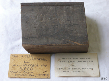 Flagstaff Hill Maritime Museum and Village
Souvenir - Wood Sample, Alexander Stephen and Sons, 1869
This teak wood sample was part of a handrail from the wreck of the ship Otago. The Otago 1869-1931 The iron-hulled 3-masted barque Otago was built in Glasgow by Alexander Stephen & Sons Ltd, Kelvinhaugh, as a merchant ship and launched in 1869. The vessel changed hands several times in the late 19th century after being sold to an Australian firm in 1871. During one of its voyages, the captain died while the ship was in port at Bangkok. Marine author Joseph Conrad was on board and, being a qualified captain, he took command and continued the journey to Sydney and Mauritius. It was the only ship he ever commanded. In 1903 the Melbourne shipping company Huddart, Parko & Co., purchased the Otago and converted it to serve as a coal hulk for use in Sydney. The Otago was later sent to Hobart, Tasmania, where it continued as a hulk until 1931. It was sold for scrap and eventually abandoned on the banks of the Derwent River at a place now known as Otago Bay, opposite Conrad Drive, Otago. The outline of the hull is still visible and a nearby plaque tells the story. There are other vessels also named Otago, one of them in the same year. Joseph Conrad (1857-1927): - Polish-born Joseph Conrad became a British subject in 1886. He was a renowned marine fiction writer and, for a short time, a mariner and Captain. As a 13-year-old boy, Joseph Conrad desired to be a sailor. At 19, he joined the British merchant marine, working in several roles. He eventually qualified as a captain but only served in this role once: from 1888 to 1889, when he commanded the barque Otago, taking over from the deceased captain and completing the ship’s journey from Sydney to Mauritius. In 1889 he began writing his first novel, Almayer’s Folly. He retired from life as a mariner in 1894, aged 36. Conrad’s affection for Australia and his visits to Australia from 1878 to 1982 were later commemorated by a plaque in Circular Quay, Sydney. Conrad continued as an author; some characters in his books were said to be inspired by his maritime experiences and the people he had met. By the end of his life, he had completed 19 novels, many stories, and essays, plus one incomplete novel, Suspense, which was finished and published posthumously. In 1924, Prime Minister Ramsay MacDonald offered Conrad a knighthood for his work but he declined. There is an 1882 sailing ship named the Joseph Conrad, after the author, that is now preserved at the Mystic Seaport Maritime Museum in the USA as part of the fleet of historic ships, used as an exhibit and a training ship. The Danish square-rigged training ship was originally named Georg Stage but was renamed by marine author Alan Villiers when he bought It in 1934. The wood sample from the Otago is significant for its association with renowned marine author Joseph Conrad, who had once commanded the vessel; it was his only command as Captain and was known as Joseph Conrad's Otago. The maritime connection with Conrad extends to items in the collection, including some of his maritime novels based on his first-hand knowledge, a wooden ship model of a ship named after him, and a navigation chart of Otago Harbour. The sample of teak is significant as an example of materials used in the construction of the 1869 iron-hulled sailing ship, built in Glasgow, Scotland, specifically for use to sail across the world with cargo to trade between the colonies including Australian ports. Wood sample; a rectangular section of a teak wood handrail that has a bead planed along one side. Two cards with the sample have inscriptions, one handwritten and one typed. The sample is from the wreck of the barque Otago, once under the command of Captain Joseph Conrad. Handwritten card: "PART OF TEAK HANDRAIL / from / Joseph CONRAD'S ship / OTAGO / (HULK at RISDON, DERWENT River, TASMANIA) Typed card: "PART OF THE TEAK HANDRAIL / FROM JOSEPH CONRAD'S SHIP / "OTAGO" / (HILK AT RISDON, DERWENT / RIVER, TASMANIA)"flagstaff hill, flagstaff hill maritime museum and village, warrnambool, maritime museum, maritime village, great ocean road, shipwreck coast, joseph conrad, joseph conrad's ship, captain joseph conrad, otago, barque otago, merchant ship, cargo ship, hulk, 1869 ship, iron hull, sailing ship, handrail, fitting, souvenir, wood sample, teak, new zealand, sydney, newcastle, tasmania, hobart, derwent river, otago harbour, otago bay, conrad drive, 19th century, mauritius, marine author, marine novel, alex villiers, georg stage -
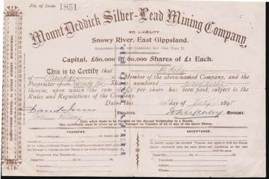 Bendigo Historical Society Inc.
Document - KELLY AND ALLSOP COLLECTION: SHARE CERTIFICATES - MOUNT DEDDICK SILVER-LEAD MINING CO, 14/07/1898 to 09/02/1899
Document. KELLY & ALLSOP COLLECTION. Two share certificates issued by the Mount Deddick Silver-Lead Mining Company, No Liability, Snowy River, East Gippsland. Certificate No. 1851 for 20 fully paid up shares @ 1 Pound each issued on 14 July 1898 to M.Kelly. Certificate No. 2113 for 5 fully paid up shares @ 1 Pound each issued on 9 Feb.1899 to M.Kelly of Bendigo. Capital raised was 60,000 Pounds from 60,000 shares. Each certificate signed by the Manager (signature not readable). Registered office - 31 Queen St., Melbourne.Mount Deddick Silver-Lead Mining Co.business, stockbroker, kelly & allsop, kelly & allsop collection, share certificates, mount deddick silver-lead mining co., m.kelly. -
 Kew Historical Society Inc
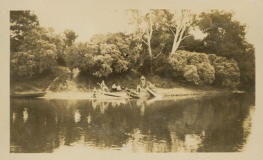
Photograph - Victorian Canoe Club, V.C.C. Studley Park, 1920-30
Canoeing on the River Yarra at Melbourne was an important and widespread recreational pursuit for Melbournians, especially in the first half of the twentieth century. The Victorian Canoe Club was formed in 1912 at a meeting in Melbourne and its first committee elected in the same year. Records indicate that the Club continued into at least the 1950s .The album has historic and social significance as a record of recreational activities (as well as canoe making) in the early years of the twentieth century. It has local significance as the site of the headquarters of the Club was in Studley park. A number of photographs in the album provide vistas of Kew on the Yarra that are otherwise unavailable.One of 24 labelled photos in part album, originating from the Victorian Canoe Club, which had its headquarters in Studley Park, Kew. The album includes a photographic record of canoe construction and also locations in Studley Park and Kew where the canoes were used. The subject of this photograph is identified as 'V.C.C. Studley Park' with its single storey weatherboard club house on the banks of the Yarra River."V.C.C. Studley Park"victorian canoe club, river yarra, studley park, boat houses, canoe clubs -
 Kew Historical Society Inc
Photograph - Victorian Canoe Club, Camp site near Burke Road, 1920-30
Canoeing on the River Yarra at Melbourne was an important and widespread recreational pursuit for Melbournians, especially in the first half of the twentieth century. The Victorian Canoe Club was formed in 1912 at a meeting in Melbourne and its first committee elected in the same year. Records indicate that the Club continued into at least the 1950s .The album has historic and social significance as a record of recreational activities (as well as canoe making) in the early years of the twentieth century. It has local significance as the site of the headquarters of the Club was in Studley Park. A number of photographs in the album provide vistas of Kew on the Yarra that are otherwise unavailable.One of 24 labelled photos in part album, originating from the Victorian Canoe Club, which had its headquarters in Studley Park, Kew. The album includes a photographic record of canoe construction and also locations in Studley Park and Kew where the canoes were used. The subject of this photograph is identified as 'Camp site near Burke Road' with four canoes on the river bank with members beside them. "Camp site near Bourke Rd"victorian canoe club, river yarra, canoe clubs, canoeing, recreation -- canoeing, burke road -- kew (vic.), kew -
 Kew Historical Society Inc
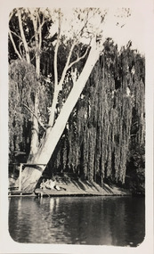
Photograph - Macauley's, Kew, 1924
Henry Beater Christian (1886-1962) , was a descendant of one of the earliest settler families in Kew. Employed at the Kew Asylum as a 'public servant', he was a skilled amateur photographer, photographing numerous scenes in Kew and on his travels around Victoria. The majority of his photographs date from 1916 to 1929. His finest photographs are housed in two photograph albums. A fine, early view of the river bank at Macauley's boat sheds on the Yarra River at Kew.Digital copy of a photograph from page 2 of the 47-page photograph album containing 261 gelatinous silver images, loaned by Diane Washfold with permission given to digitise and hold a copy in our collection. The photograph is of the river bank at Macauley's boat sheds on the Yarra River at Kew. The boat sheds were located at the west end of Molesworth Street. The photograph is taken from the Yarra Bend Park side of the river, or from a boat on the river. A group, probably members of the photographer's family, are sitting underneath a giant weeping willow."Macauley’s Kew"henry beater christian (1886-1962), landscape photography, kew (vic.) — yarra river, christian-washfold collection, photograph albums, macauley's boat sheds -
 Kew Historical Society Inc
Photograph - Flooding of the Yarra Valley at Kew East, 1974
Flooding of the Yarra Valley, including that section of the Yarra bordering Kew and Kew East in the north and west of the municipality, was a regular occurrence. Extreme flood events of the Yarra River are recorded to have occurred in 1891, 1901, 1916, 1923 and 1934. The Municipality of Kew's response to these floods was to enact planning decisions restricting residential development in flood prone areas following the floods of 1916, 1921 and 1934. While floods continued after the development of the Upper Yarra Reservoir (construction 1948-57), the regularity and extent of these inundations diminished. During the nineteenth century, the land abutting the south side of the Yarra in Kew was devoted to dairy farming. In the twentieth century, before and after the construction of the Eastern Freeway, much of this low-lying area was used as golf courses and public parks.Late example of the capacity of the Yarra Valley at Kew to flood, even though drainage works and the Upper Yarra Reservoir had reduced their regularity.Original black and white print photograph of the low-lying land at East Kew under floodwater on 16 May 1974. The vantage point of the photographer is Lister Street. Flooding was caused by overflowing water in Glass' Creek and the River Yarra. Annotation verso: "Lister Street looking north / Flood level / 16 May 1974 11.30am / R.L. 46.04"hays paddock, floods, yarra river, glass' creek, lister street -
 Kew Historical Society Inc
Photograph - Flooding of the Yarra Valley at Kew East, 1974
Flooding of the Yarra Valley, including that section of the Yarra bordering Kew and Kew East in the north and west of the municipality, was a regular occurrence. Extreme flood events of the Yarra River are recorded to have occurred in 1891, 1901, 1916, 1923 and 1934. The Municipality of Kew's response to these floods was to enact planning decisions restricting residential development in flood prone areas following the floods of 1916, 1921 and 1934. While floods continued after the development of the Upper Yarra Reservoir (construction 1948-57), the regularity and extent of these inundations diminished. During the nineteenth century, the land abutting the south side of the Yarra in Kew was devoted to dairy farming. In the twentieth century, before and after the construction of the Eastern Freeway, much of this low-lying area was used as golf courses and public parks.Late example of the capacity of the Yarra Valley at Kew to flood, even though drainage works and the Upper Yarra Reservoir had reduced their regularity.Original black and white print photograph of the low-lying land at East Kew under floodwater on 16 May 1974. The vantage point of the photographer is Lister Street. Flooding was caused by overflowing water in Glass' Creek and the River Yarra. Annotation verso: "Lister St looking same as No.3 / 16 May 1974 11.30"floods, yarra river, glass' creek, lister street -
 Orbost & District Historical Society
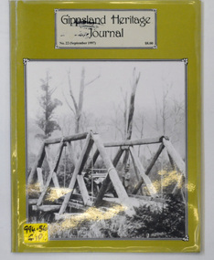
journal, Gippsland Heritage Journal, September 1997
This issue was edited by Meredith Fletcher.This item is a useful reference on the history of Gippsland.A 64 pp magazine, titled Gippsland Heritage Journal. The cover is olive green with a b/w photograph of the Snowy Creek bridge at Mitta Mitta in 1914. The magazine is dated September 1997 and is covered in plastic. It contains photographs and articles on the history of Gippsland.On the outside back cover is a library barcode. On the front is a call no. 994.56 GIPgippsland-heritage-journal history-gippsland -
 Orbost & District Historical Society
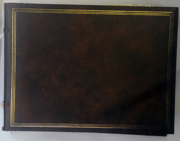
album, 1990's?
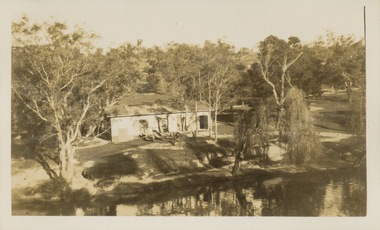
This album was used at the Orbost Visitor Information Centre (the Slab Hut). The Slab Hut (Orbost Visitor Information Centre) is an Orbost icon. This slab hut was built in 1872 as a family dwelling on a site about 3 km upstream from the junction of the Buchan and Snowy Rivers about 40 kms from Orbost on the Yalmy Rd. No nails were used in the construction; it was all wired together. After a period in storage the slab hut was opened in its present location in Orbost as the Information Centre in 1987.This item is a useful reference tool for the history of Orbost.A large photo album containing copies of photographs, some historical articles and b/w photos of Orbost. The covers are brown with a narrow gold frame. it has no spine and the covers are tied with tape. The pages, all different sizes, are bolted in.orbost-history album-photographs -
 Orbost & District Historical Society
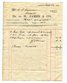
account, November 29 1911
This account was sent fro H. James & Co to Robert Pullar Cameron. Henry James (1860-1932) was a well-known identity in the Orbost district. He was a stock agent and auctioneer who helped to establish the seed bean industry in Orbost. He was the second secretary of the Snowy River Shipping Co. as well as a shire councillor and prominent member of MUIOOF. Robert Pullar Cameron was a Shire Councillor for many years. He married Penuel Hossack and had a family of James, Flora, Penuel and Alex. Henry James (1860-1932) was a well-known identity in the Orbost district. This item is an example of a hand-written document used by an early Orbost business. It is a useful research tool.Two white paper accounts , red lines and black print. It is from H. James & CO - Freighters to R. Cameron.james-henry cameron-robert-pullar account -
 Orbost & District Historical Society
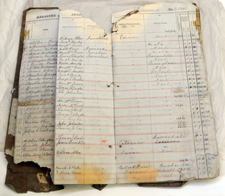
register, after 1888
Jarrahmond State School, 2745, opened on March 19 1886 with Campbell Mackay as the head teacher and operated on apart-time basis with Orbost State School, 2744. The first building, erected on the bank of the Snowy River, was moved in approximately 1892 to McLeod's Lane. In 1914 a new building was erected by George Lurkins, and this catered for the local children until a school bus service took them to Orbost in 1949. The school building was transferred also and became an integral part of Orbost State School.This school record is of immediate interest and value to the pupils and staff who have learned and taught in theJarrahmond State School. The record also has a much wider significance, to the community in which the school is situated, as a record and research tool.A hand-written school register for Jarrahmond State School. It records the pupils enrolled 1888 until 1907. It has a brown cover with lined pagess which are ruled in tables to list pupils.jarrahmond education school-register mackay-campbell -
 Orbost & District Historical Society
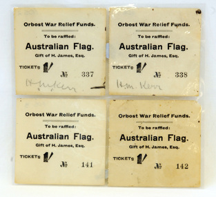
raffle tickets, WW1
The proceeds of the raffle assisted in the War Relief collection fund. These tickets were purchased by Hilda Margaret Kerr. She was the daughter iof Dr and Mrs Kerr. The prize of an Australian flag was donated by H.James. Henry James (1860-1932) was a well-known identity in the Orbost district.He was a stock agent and auctioneer who helped to establish the seed bean industry in Orbost. He was the second secretary of the Snowy River Shipping Co. as well as a shire councillor and prominent member of MUIOOF. These raffle tickets are a reminder of the efforts made by the families and friends of those who served in the WW1 conflict.Four raffle tickets. They are in black print on white paper. The tickets are for a War Relief Raffle of the Australian flag which was a gift of H. James Esq. The tickets were purchased by Miss Hida Margaret Kerr and each cost 1/- (one shilling).On ticket nos. 337 and 338 - in handwriting H.M. Kerrraffle-tickets war-relief ww1 kerr family james-h -
 Orbost & District Historical Society
black and white photograph, 1920s - 1930s
There is no record of which family is in the photograph. The slips at Corringle was a popular picnic area for Orbost people. Corringle Slips is situated at the mouth of the Snowy River Estuary. The Corringle Slips were built by Samuel Richardson and sons during the time when the Orbost Shipping Company was operating. The Slips were washed away in the 1893 floods and reassembled by Martin Jorgensen who then became a part owner of the Slips. In the late 1890's, Corringle was a thriving rural community. (Information from Discovering Marlo brochure)This is a pictorial record of family life in Orbost in the first half of the 20th century. It portrays a typical Orbost family enjoying a leisure activity. The clothing can be seen as more formal than that worn at a family picnic in the present day,A black / white photograph of a group of people (adults and children) seated around a table set with a tablecloth on which are teacups, bottles of drink and cake. in the front is a bucket and two metal boxes. They are well-dressed with the men and boys wearing jackets and ties and some of the women wearing cloche style hats.on back - "Family at Slips"corringle-slips-marlo picnic-recreation -
 Bendigo Historical Society Inc.
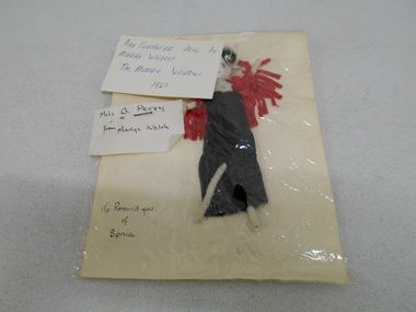
Textile - GERTRUDE PERRY COLLECTION: DOLLS
Two small dolls. One is in a plastic pocket, attached note: pipe cleaner doll by Madge Welch, The Merry Widow, 1953. Miss G. Perry from Madge Welch to remind you of Sonia. this doll is in a black dress. The other is in a red dress.ephemera, mementoes, gertrude perry collection -
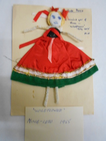 Bendigo Historical Society Inc.
Leisure object - GERTRUDE PERRY COLLECTION: PIPE CLEANER DOLL 'WILDFLOWER' PRODUCTION 1954
Pipe cleaner doll, dressed in green and red costume, mounted on buff cardboard. Written in top RH corner 'Gertrude Perry, to remind you of Nina, 'Wildflower, July 1955' M.W. Small card, not attached, is written 'Wildflower" Nina - Lead 1955.person, individual, gertrude perry -
 Melbourne Tram Museum
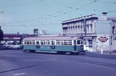
Slide, Keith Caldwell, Mar. 1962
Agfa Colour slide, cardboard, by Keith Caldwell dated March 1962 W6 948 turning from Flinders Lane into William St. In the background is the Railway Viaduct with a Tait Train, F A Nelken building (?), a sign for Cellokraft paper and Magikist Carpet Cleaners.In ink "March 1962"trams, tramways, w6 class, flinders lane, william st, tram 948 -
Port Melbourne Historical & Preservation Society
Photograph - Aerial view of Yarra River and surrounds, 1990s
COPYRIGHT THE AGE Aerial photograph showing the Yarra River, Webb Dock, Port Melbourne beach, Princes pier, West Gate Bridge, Maribyrnong River, Swanston Dock and Melbourne City skyline. Taken mid 1990sStamped "Copyright. This photograph may not be reproduced without permission in writing from the Photo sales department of "the Age"'built environment - commercial, engineering - bridges, fishermans bend, natural environment - beaches and foreshore, piers and wharves - princes pier, piers and wharves - webb dock, transport - shipping, yarra river, west gate bridge, sandridge beach, maribyrnong river, swanston dock -
 Victorian Aboriginal Corporation for Languages
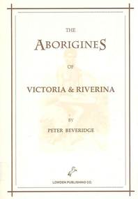
Book, Peter Beveridge et al, The Aborigines of Victoria and Riverina, 2008
The Beveridges pioneered the Swan Hill area on the Murray River and lived among the People of the Murray River. They learned the Aboriginal dialects, lore and customs. Peter Beveridge faithfully recorded these and his book was published posthumously by his family.maps, b&w illustrations, b&w photographsvictorian history, murray river -
 Lakes Entrance Historical Society
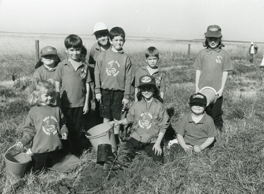
Photograph - Swan Reach School, Lakes Post Newspaper, 1996
Photo appeared in Lakes Post Newspaper 8 May 1996, page 1.Black and white photograph of ten Swan Reach Primary School students planting trees on the banks of the Tambo River, in conjunction with Johnsonville Angling Club, SGAP and Tambo / Nicholson River management Board. Swan Reach Victoriaschools, students, community organisation -
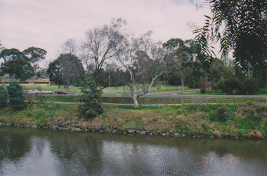 University of Melbourne, Burnley Campus Archives
Photograph - Colour print, Konica, Lagoon or Boulevard Paddock, Unknown
2 colour photographs. 1. Lagoon or Boulevard Paddock and Quad Classrooms from the other side of the Yarra River. 2.View towards the rock bank behind Swan Street from the other side of the Yarra River.lagoon paddock, boulevard paddock, quad classrooms, yarra river -
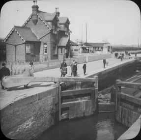 Federation University Historical Collection
Photograph - Glass Plate, Henry Sutton, Hertford Lock by Henry Sutton, c1891
Henry Sutton was born in Ballarat into the musical Sutton Family. He is known as an important Australian inventor. Photograph of Hertford Lock. lockkeepers house. A lock is a device used for raising and lowering boats, ships and other watercraft between stretches of water of different levels on river and canal waterways. Hertford Lock is situated on the River Lea on the eastern side of Hartham Common, Hertford in the English county of Hertfordshire. It is owned and managed by British Waterways and is the first lock of the River Lee Navigation.henry sutton, glass plates, photography, swans