Showing 23714 items
matching creeks
-
 Whitehorse Historical Society Inc.
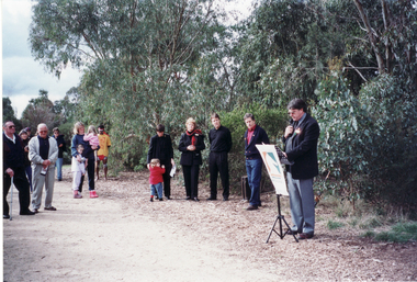
Photograph, Opening of Whitehorse Heritage Trail, 2/07/2001 12:00:00 AM
Heritage Trail funded by grant to the City of Whitehorse from Commonwealth of Australia to celebrate 100 years of Federation.Coloured photograph of Mayor of City of Whitehorse, Cr. Bill Bowie speaking at opening of Whitehorse Heritage Trail at Gardiners Creek Reserve, Burwood. On left: Cr Bernie Millane, Geoff Pascoe, City of Whitehorse, Cr. Kaele Way, and Anna Burke, MHR for Chisholm.whitehorse heritage trail, city of whitehorse, millane, bernie, pascoe, geoff, way, kaele, burke, anna -
 Whitehorse Historical Society Inc.
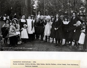
Photograph, Children at Coronation Celebrations, 1911
Used by Robin Da Costa in 'Blackburn - A Picturesque History'.Black and white photo of Children at Coronation Celebrations, on 29 June 1911 in Blackburn. (Captioned)|Photo includes but not identified - Lillie Merton, Ruby Brookes, Myrtle Walker, Alice Creek, Vera Salisbury and Beatrice Henwood.|See Page 101 of Da Costa book.merton, lillie, rooks, ruby, walker, myrtle, creek, alice, salisbury, vera, henwood, beatrice, coronation 1911 -
 Southern Sherbrooke Historical Society Inc.
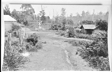
Photograph - Aura Station and train
Photo taken from Menzies Road, Menzies Creek, looking towards the railway station. On the left is the house which served as the first official post office. The station is in the centre, with what appears to be a down train in the station. On the right is the stationmaster's house in its original position. -
 Bendigo Historical Society Inc.
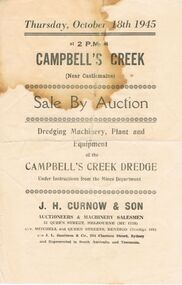
Document - IAN DYETT COLLECTION: AUCTION CATALOGUE - CAMPBELL'S CREEK DREDGE
Auction catalogue for a sale on the 18th October, 1945 at the Campbell's Creek Dredge (Near Castlemaine) under instructions from the Mines Department. For sale was Dredging Machinery, Plant and Equipment. J. H. Curnow & Son were the auctioneers. Catalogue contains descriptions of some lots.business, auctioneers, j h curnow & son pty ltd, ian dyett collection - auction catalogue - campbell's creek dredge, mines department, j h curnow & son, j l jamieson -
 Bendigo Historical Society Inc.
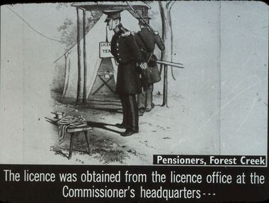
Slide - DIGGERS & MINING. THE GOLD LICENCE, c1850s
Diggers & Mining. The gold licence. The Government Camp. Slide: Pensioners, Forest Creek. The licence was obtained from the licence office at the Commissioner's headquarters. Slide shows Commissioner and an officer outside the Licence Tent. Markings: 9 994.LIF. 4. Used as a teaching aid.hanimounteducation, tertiary, goldfields -
 Bendigo Historical Society Inc.
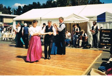
Photograph - PETER ELLIS COLLECTION: PEOPLE DANCING
Colour photograph. People dancing. Piazza Dance Displays Daily 11am - 6 pm. Bush Band. Banjo. Couples. Wooden stage. Rear of photo reads 10/1 1st Canberra NFF Emu Creek & Bush Dance & Music Club of Bendigo.photo, group, dance -
 Kew Historical Society Inc
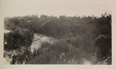
Photograph - Yarra River, Studley Park, 1924
Henry Beater Christian (1886-1962) , was a descendant of one of the earliest settler families in Kew. Employed at the Kew Asylum as a 'public servant', he was a skilled amateur photographer, photographing numerous scenes in Kew and on his travels around Victoria. The majority of his photographs date from 1916 to 1929. His finest photographs are housed in two photograph albums. Digital copy of a photograph from page 7 of the 47-page photograph album containing 261 gelatinous silver images, loaned by Diane Washfold with permission given to digitise and hold a copy in our collection. This photograph appears to be of the junction of the Yarra River and the Merri Creek."Studley Park / Kew"henry beater christian (1886-1962), landscape photography, kew (vic.) — yarra river, christian-washfold collection, photograph albums, merri creek, yarra river -
 Tarnagulla History Archive
Article: Old Tarnagulla, The Romance of Poverty Reef
Donald Clark Collection.A typed article with title 'Old Tarnagulla, The Romance of Poverty Reef'. Discusses a Minute Book of the Sandy Creek Progress Committee which was held (at the time of writing) by a member of the Old Tarnagulla-ites based in Melbourne. Written by C.P. Ward, date unknown, probably 1970s. -
 Ringwood and District Historical Society
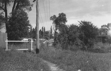
Photograph, Looking to Adelaide St. from Reynolds Ave. Ringwood (across Mullum Creek) 1973. Site of bridge washed away in floods 1931. Infant Welfare Centre (Dr. Hewitts) on right
Black and white photographCatalogue card reads, "Looking to Adelaide St. from Reynolds Ave. (across Mullum Creek) 1973. Site of bridge washed away in floods 1931. Infant Welfare Centre (Dr. Hewitts) on right." -
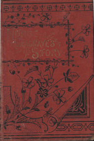 Nillumbik Historical Society Incorporated
Book - Hardcover book, Agnes Giberne, Nurse Seagrave's Story
Red board cover with an etching of floral design in black on the cover and back - 128 pagesfiction -
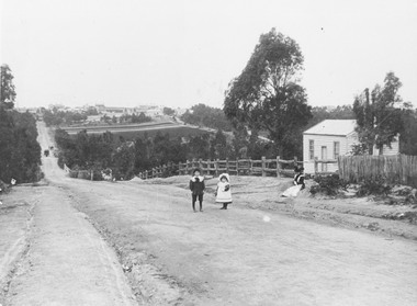 Ringwood and District Historical Society
Photograph, Addison home 1902 Ringwood in background
Black and white photograph of scene showing unmade road with two children, a boy and a girl standing outside a small wooden building. Lady is sitting by the side of road. Road dips down to a bridge then rises again towards distant settlement in background. (3 copies)Typed below enlarged photo, "Addison home, 1902 - Opposite present St. Paul's, Warrandyte Road". Written on backing sheet, "Andersons Creek Rd. 1903. Mrs. Addison (Annie Kennedy) and family - Annie, born 1897 and William. Their house at right was on a 5 acre block. Ringwood in background". Backing sheet of another copy reads, "Andersons Creek Road 1902 (Warrandyte Rd. looking south). Mrs. Addison (Annie Kennedy) and family. Annie (Jnr), born 1897 and Samuel John James William, born 1894. Their home, at right, was on a 5 acre block. Ringwood in background - burned down by pet magpie. T. Grant's land ploughed - now Eastland. Adelaide St. seen on right of it. Mullum Creek Bridge at foot of hill". Typed below this photograph, "Warrandyte Rd. Ringwood looking south from near Mullum Rd. Ringwood in background. Maroondah Highway at top of hill with Mullum Creek bridge seen in dip - 1902". -
 Greensborough Historical Society
Map, Melbourne and Metropolitan Board of Works. Survey Division, MMBW, Yarra 2500 / 16.23. Diamond Creek, 1978_02
Melbourne and Metropolitan Board of Works. Yarra 2500 [base map] 16-23. Diamond Creek. Parish of Nillumbik 3310. Municipalities of Diamond Valley 257 and Eltham 238. Prominent streets include: Phipps Crescent, Bishop Avenue, and Reynolds Road. Includes the former Diamond Creek Technical School.MMBW Map in 1:2500 [scale] series. Cream parchment with green tape reinforcing on edges and punched holes on left edge.mmbw, melbourne and metropolitan board of works, shire of diamond valley, diamond creek - maps -
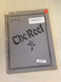 Stawell Historical Society Inc
Book, Stawell & District State Schools, The Reef - State School Magazines – October 1921 Vol 1 No 1, 1921
The First Edition of the "The Reef" a Magazine for Local State Schools, Stawell, Black Range, Green's Creek, Illawarra, Pomonal, Glenorchy, Deep Lead, Morrl Morrl, Joel Joel, Concongella, Salt Creek, Great Western, Wallaloo East, Campbell's Bridge, Callawadda, Warngar, Frechman's, Landsborough West and Landsborough.733: Grey Card Cover with black Design Balck Text Inside 733A: Purple Card Cover with black Design Balck Text Inside 733B: Fawn Card Cover with black Design Balck Text Inside Badly Torn 733C: Brown Card Cover with black Design Balck Text Inside 733D: Brown Card Cover with black Design Balck Text Inside Cover torn Bottom Right Missing 733E: Brown Card Cover with black Design Balck Text Inside Cover torn Bottom Right Missing 733F:Brown Card Cover with black Design Balck Text Inside Cover torn top Right MissingOctober 1921 Vol 1 ...... No.1 The Reef 733A; No. 5 October 1927 The Pinnacle Stawell Inspectorate School Magazine. Not Failure But Low Aim Is crime R.L. Henerson Price One Shilling 733B: No. 2 October 1924 The Pinnacle Stawell Inspectorate School Magazine. Not Failure But Low Aim Is crime R.L. Henerson Price One Shilling 733C: No. 1 September 1923 The Pinnacle Stawell Inspectorate School Magazine. Not Failure But Low Aim Is crime R.L. Henerson Price One Shilling 733D: No. 3 October 1925 The Pinnacle Stawell Inspectorate School Magazine. Not Failure But Low Aim Is crime R.L. Henerson Price One Shilling 733E: No. 4 October 1926 The Pinnacle Stawell Inspectorate School Magazine. Not Failure But Low Aim Is crime R.L. Henerson Price One Shilling (Cynthia Bodey Top Right Hand Written) 733F: No. 6 October 1928 The Pinnacle Stawell Inspectorate School Magazine. Not Failure But Low Aim Is crime R.L. Henerson Price One Shilling stawell education -
 Kiewa Valley Historical Society
Skis - Downhill with bindings, c1970's
Skiing was started as an industry in the near by skiing village of Falls Creek, when many of the migrant workers who were employed by the Kiewa Hydro Scheme thought the near by snow fields would be a good place to ski. Gradually this village has developed into a major skiing resort during the Victorian winter. Many people who lived in Mt Beauty, Bogong Village or Falls Creek itself have either grown up snow skiing or spend their winters skiing. As a consequence Falls Creek developed a skiing community from this base and some skiers went onto represent Australia in skiing competitions and the Winter Olympic games due to their association with Falls Creek and or Mt Beauty. These skiis were used by Doug Mc Conville in the 1976 Winter Olympics. He crashed in his Olympic event. Doug Mc Conville skied locally at Falls Creek.Pair of dark blue Dynastar downhill skis with lighter blue red & white logo. Stainless steel, red & black bindings with S626 1.2.3.4.inscription. Blue tags at zip ends. Y180 9 kL37 09 11565 Dynastar Polysoft Label on skis (red white blue label) on dark blue skis - Bindings S626 1.2.3.4. Salomondownhill skis. bindings. doug mc conville. 1976 olympics. snow. falls creek. -
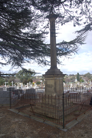 Ballarat Heritage Services
Photograph - Photograph - Colour, Burke and Wills Memorial at Bendigo Cemetery, 2018, 02/09/2018
Robert O'Hara Burke and Thomas Pope Besnard were childhood friends. As sexton of the local Back Creek Cemetery Thomas Besnard organised a subscription to raise the money for a monument to Burke, Wills and Gray. A subscription of one shilling, no more and not less, was asked so all subscribers were equal. The Bendigo monument was designed by Adam Duncan and features a Corinthian column mounted on a foundation stone, topped with a Grecian urn draped with the Union Jack. The stone for the monument was quarried from New Chum Mine. The site in the Bendigo Cemetery was selected by Besnard so the monument was on a grass knoll well clear of any other graves. The design included landscaping with a path and garden beds that provided dignified access. The Burke and Wills Monument in Bendigo has been entered on the Register of the National Estate as being important for its association with historical events and developments associated with exploration in the early days of Colony of Victoria. Two conifers remain from the original group sent by Mueller of the Melbourne Botanical Gardens to develop the garden layout on the knoll. These two trees are listed as Significant Trees by City of Greater Bendigo. The foundation block was laid on 20 August 1862 by Chairman of the Bendigo Municipality, Charles Burrows – exactly two years after the Expedition left Melbourne. A half day holiday was declared by Bendigo Council, and a procession left the Bendigo Town Hall and marched to the cemetery where 8000 people were gathered and another 4000 lined the route. John King was unable to attend due to ill health. Chairman of the Municipality of Bendigo, Charles Burrows, gave a long address, and diaries of members of the expedition, the Sandhurst Almanac, the Bendigo Advertiser, the Bendigo Independent Evening News, photographs of the deceased, photographs of Public Buildings in Bendigo, a Sydney half sovereign and all the silver coins of the Realm were wrapped in a Union Jack and placed in a niche in the foundation stone. Fifteen months later a column was erected on the foundation stone after Besnard openly criticised the Memorial Committee for their lack of action. The Bendigo Advertiser was disappointed at the location of the monument preferring a more central location and in 1893 an attempt was made to move the monument to Rosalind Park. On 19 May 1893, Mr Minto, the City Surveyor of the Bendigo MunicIpality reported it would cost £25, and no other action occurred. In 1940 the land around the memorial was sold off as grave sites and the paths and garden beds disappeared with graves now surrounding the base of the monument. The Burke and Wills Monument in Bendigo Cemetery was entered on the Register of the National Estate for its association with historical events and developments associated with exploration in the early days of Colony of Victoria. Two conifers remain from the original group sent by Mueller of the Melbourne Botanical Gardens to develop the garden layout on the knoll. These two trees are listed as Significant Trees by City of Greater Bendigo.Burke and Wills Memorial at Bendigo Cemetery, 2018Erected by the people of Bendigo in honor of the Victorian Explorers, Burke, Wills, Gray and King who first crossed the continent of Australia. King alone surviving the privation and suffering under which his three brave ill-fated companions sank. A.D. 1862. Robert O'Hara Burke, leader of the Victorian Expedition, left Melbounre 24th August 1860. Reached Carpentaria 12th Feby 1861. Died on his return at Coopers Creek, 30th June 1861. Charles Gray, died also on his return at Polygorum Swamp. 17th April 1861. William John Wills, second in command, died also near Coopers Creek, 29th June 1861. bendigo cemetery, burke and wills, burke and wills memorial, william john wills, john o'hara burke, charles gray, polygonum swamp, coopers creek, victorian expedition, carpentaria, bendigo public cemetery, bendigo remembrance park, thomas pope besnard -
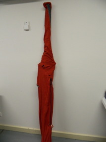
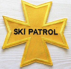 Falls Creek Historical Society
Uniform - Ski Patrol Star, 1960s
The Falls Creek Ski Patrol dates back to the early 60s after skiing in Falls Creek became popular. The first ski patroller in Falls Creek was Brian Caddy with two casual ski patrollers Rob Sarroff and David Crooke. Bob Howe as President of the Albury Ski Club, and a few competent skiers from his club and Myrtleford Ski Club, successfully completed the St Johns Ambulance First Aid Certificate in the hope that the Management Committee of the day would roster on two patrollers a day in return for free ski lift tickets. This plan fell through, but the year after Brian Caddy was employed as head of Ski Patrol. In 1972 the “official” Falls Creek Ski Patrol was created under the advisement of Dr Rodney Moss with the support of the Management Committee. At that time, there was one or two patrollers on staff, increasing to five members at peak times. By 1977 there were six or seven patrollers, and currently there are around 40 patrollers on the team with 13-14 rostered on each day during peak season. In 1974 the Australian Ski Patrol Association (ASPA) was formed. On the 14th of March 1975, the Falls Creek Tourist Area Management Committee applied for membership to ASPA. At that time, Falls Creek Ski Patrol was known as Falls Creek Ski Rescue. This cloth badge is in the shape of the Maltese Cross. It was the insignia of the Knights Hospitallers of St John who ministered to sick and injured pilgrims as well as fighting in the Crusades. The Maltese Cross has become a well-known symbol of protection, first-aid and assistance worldwide.A yellow cloth patch badge in the shape of the Maltese Cross. The outline of the star has been machine embroidered in yellow thread. The words "SKI PATROL" are embroidered in black thread.SKI PATROLfalls creek ski patrol, skiing safety, falls creek services -
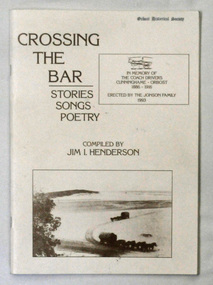 Orbost & District Historical Society
Book, Crossing The Bar, 1993
Jim Henderson has written several books about the Wareiwa and Hospital Creek area.This is a useful reference item.A 40 pp book titled Crossing The Bar , Stories,Songs, Poetry. On the front cover is an early photograph of two coaches and horses on the sand bar at Lakes Entrance at the Gippsland Lakes. In the top right corner is a photograph of part of the memorial plaque erected by the Jonson family of Tostaree in 1993. " In memory of the coach drivers Cunninghame-Orbost 1886-1916." The book was compiled by Jim I. Henderson.Jim Henderson 31/10/1993wairewa nowa-nowa hospital-creek waygara transport-history-east-gippsland -
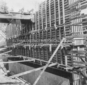
 Eltham District Historical Society Inc
Album - Photograph, J.A. McDonald, Eltham-Greensborough Road, 29 July 1956
Diamond Creek Bridge (Bridge Street Bridge) Pile grid – 29th July 1956Record of various Shire of Eltham infrastructure works undertaken during the period of 1952-1962 involving bridge and road reconstruction projects, sometimes with Eltham Shire Council Project Reference numbers quoted. It was during this period that a number of significant improvements were made to roads and new bridges constructed within the shire that remain in place as of present day (2022). In many situations, the photos provide a tangible visible record of infrastructure that existed throughout the early days of the Shire. The album was put together by or under the direction of the Shire Engineer, J.A. McDonald.infrastructure, road construction, shire of eltham, bridge construction, bridge street bridge, eltham, eltham-greensborough road, 1956-07-29 -
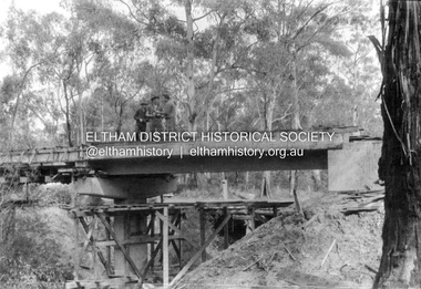
 Eltham District Historical Society Inc
Album - Photograph, J.A. McDonald, Eltham-Greensborough Road, Oct. 1956
Bridge over Diamond Creek (Bridge Street Bridge) Greensborough pier, October, 1956Record of various Shire of Eltham infrastructure works undertaken during the period of 1952-1962 involving bridge and road reconstruction projects, sometimes with Eltham Shire Council Project Reference numbers quoted. It was during this period that a number of significant improvements were made to roads and new bridges constructed within the shire that remain in place as of present day (2022). In many situations, the photos provide a tangible visible record of infrastructure that existed throughout the early days of the Shire. The album was put together by or under the direction of the Shire Engineer, J.A. McDonald.infrastructure, road construction, shire of eltham, bridge construction, bridge street bridge, eltham, eltham-greensborough road, 1956-10 -
 Eltham District Historical Society Inc
Album - Photograph, J.A. McDonald, Eltham-Greensborough Road, Oct. 1956
Bridge over Diamond Creek (Bridge Street Bridge) Eltham pier, October, 1956Record of various Shire of Eltham infrastructure works undertaken during the period of 1952-1962 involving bridge and road reconstruction projects, sometimes with Eltham Shire Council Project Reference numbers quoted. It was during this period that a number of significant improvements were made to roads and new bridges constructed within the shire that remain in place as of present day (2022). In many situations, the photos provide a tangible visible record of infrastructure that existed throughout the early days of the Shire. The album was put together by or under the direction of the Shire Engineer, J.A. McDonald.infrastructure, road construction, shire of eltham, bridge construction, bridge street bridge, eltham, eltham-greensborough road, 1956-10 -
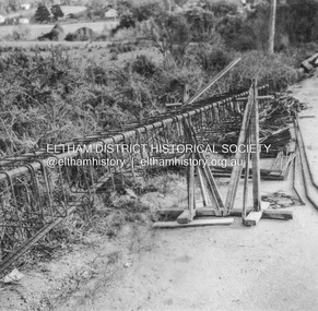
 Eltham District Historical Society Inc
Album - Photograph, J.A. McDonald, Henley Road Bridge over Watsons Creek, Aug. 1962
Henley Road Bridge over Watsons Creek Yarra Glen Abutment August 1962Record of various Shire of Eltham infrastructure works undertaken during the period of 1952-1962 involving bridge and road reconstruction projects, sometimes with Eltham Shire Council Project Reference numbers quoted. It was during this period that a number of significant improvements were made to roads and new bridges constructed within the shire that remain in place as of present day (2022). In many situations, the photos provide a tangible visible record of infrastructure that existed throughout the early days of the Shire. The album was put together by or under the direction of the Shire Engineer, J.A. McDonald.H941 stamped on reverse (film processing #)infrastructure, shire of eltham, bridge construction, road construction, bushfires, 1962-08, bend of islands, henley road, henley road bridge, kangaroo ground, oxley bridge, watsons creek -
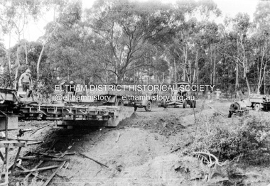 Eltham District Historical Society Inc
Album - Photograph, J.A. McDonald, Henley Road Bridge over Watsons Creek, Sep. 1962
Henley Road Bridge over Watsons Creek Yarra Glen Abutment September 1962Record of various Shire of Eltham infrastructure works undertaken during the period of 1952-1962 involving bridge and road reconstruction projects, sometimes with Eltham Shire Council Project Reference numbers quoted. It was during this period that a number of significant improvements were made to roads and new bridges constructed within the shire that remain in place as of present day (2022). In many situations, the photos provide a tangible visible record of infrastructure that existed throughout the early days of the Shire. The album was put together by or under the direction of the Shire Engineer, J.A. McDonald.H941 stamped on reverse (film processing #)infrastructure, shire of eltham, bridge construction, road construction, bushfires, bend of islands, henley road, henley road bridge, kangaroo ground, oxley bridge, watsons creek, 1962-09 -
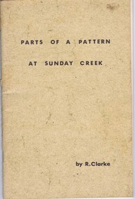 Greensborough Historical Society
Booklet, Ruth Clarke, Parts of a pattern at Sunday Creek, 1971
Historical notes on the community of Sunday Creek, south of Broadford off the Hume Highway in Victoria45 p., black and white illustrationssunday creek, victoria, broadford -
 Greensborough Historical Society
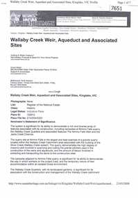
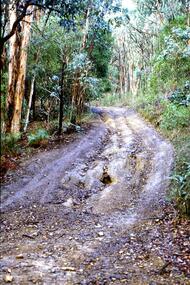
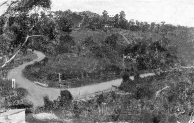
Article - Article - Website, Wallaby Creek Weir, Aqueduct and associated sites, Kinglake, 2007
A short history of Kinglake's Wallaby Creek Weir and aqueduct in relation to Melbourne's water supply. Paper copy of website article, 7 p. text.melbourne water supply, kinglake, wallaby creek weir, aqueducts -
 Greensborough Historical Society
Slide - Photograph, John Ramsdale, Barbers Creek, Mernda: Slide 6, 1990s
Photograph shows washed out bush track with gully erosion at Barbers Creek, Mernda.Part of the John Ramsdale collection of slides and audio visual material.Colour photograph scanned from slide.No maker's marks. No caption on slide.erosion, barbers creek mernda -
 Greensborough Historical Society
Photograph - Digital image, St Helena and Diamond Creek Roads, 1925c
Photograph of the intersection of St Helena and Diamond Creek Roads pre-1950. The scene is rural.Digital copy of black and white photograph.st helena road, diamond creek road, greensborough -
 Greensborough Historical Society
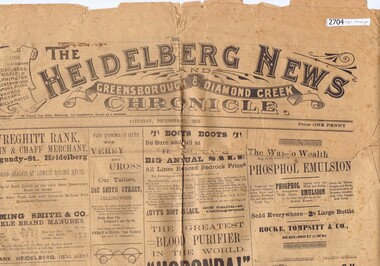
Newspaper, Heidelberg News, The Heidelberg News and Greensborough & Diamond Creek Chronicle 1905, 23/12/1905
Original copy of The Heidelberg News and Greensborough & Diamond Creek Chronicle from December 1905.Contains local news and many advertisementsBroadsheet, 4 p., folded twiceheidelberg, greensborough, diamond creek -
 Greensborough Historical Society
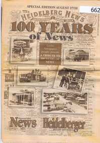
Newspaper, Diamond Valley Leader, 100 Years of News, 27/08/1997
Issued to commemorate the centenary of the first issue of the "Heidelberg News and Greensborough and Diamond Creek Chronicle".This edition features many historical photographs and advertisements as well as some from 1997.A 40 page commemorative edition of the Diamond Valley news in black and sepia print.Nilgreensborough, diamond creek, heidelberg, local newspapers, leader group newspapers -
 Eltham District Historical Society Inc
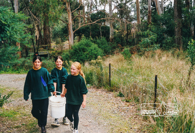
Photograph, Richard Pinn, Tree Planting, Hurstbridge Primary School students, Fergusons Paddock, Hurstbridge, c.1999, 1999c
The newly-planted trees had to be watered, the nearby creek being the most convenient source.Colour photographhurstbridge primary school, fergusons paddock -
 Eltham District Historical Society Inc
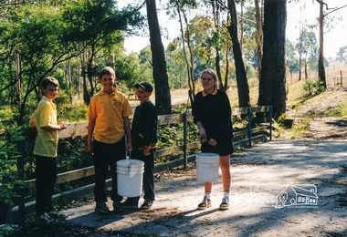
Photograph, Richard Pinn, Tree Planting, Hurstbridge Primary School students, Fergusons Paddock, Hurstbridge, c.1999, 1999c
The newly-planted trees had to be watered, the nearby creek being the most convenient source.Colour photographhurstbridge primary school, fergusons paddock