Showing 10480 items
matching lander
-
 Tatura Irrigation & Wartime Camps Museum
Book, Settling, 1984
The relationship between Victorians and the land which has sustained them through the long human occupation of the state is the focus of the bookYellow cover. Illustration on front by Tom Roberts, Australian (1856-1931) - "The Artists Camp. Content info on back cover. 274 pages.victorians, dingle t, roberts t, tatura -
 Tatura Irrigation & Wartime Camps Museum
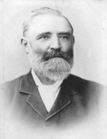
Document, Thomas Hogan
Hogan, Thomas, early selector of land, member of Rodney Shire Council and Rodney Irrigation Trust.|Shire of Rodney|TaturaDocument and photograph -
 Ballarat Heritage Services
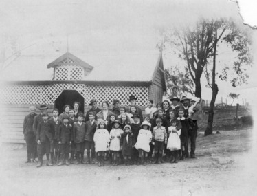
Photograph - Black and White, Yandoit Hill State School No. 691, c1919
The land for this school was donated by Carlo Gervasoni. When it closed it was moved to the corner of Main Road and Seventh Street, Hepburn Springs.A number of adults, and students of Yandoit Hill State School, stand in front of the playground shed. One man is in an AIF uniform, and another has a slouch hat on. yandoit creek, yandoit hills, education -
 Ballarat Heritage Services
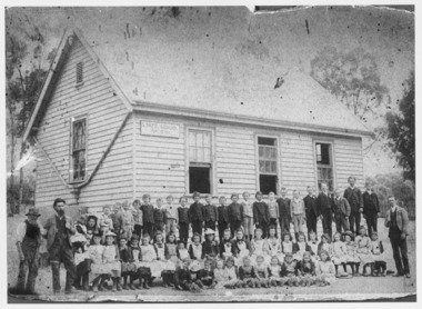
Photograph - Black and White, Yandoit Hill State School No. 691
The land for this school was donated by Carlo Gervasoni. When it closed it was moved to the corner of Main Road and Seventh Street, Hepburn Springs. Black and white photograph of three men standing either side of a number of school children of Yandoit Hill State School. yandoit, yandoit hills, yandoit creek, yandoit hill state school, gervasoni, hepburn springs -
 Sunbury Family History and Heritage Society Inc.
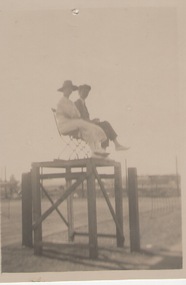
Photograph, C1920s - 1930s
The photograph was taken a the old tennis courts which were on railway land between Evans Street in Sunbury and the railway line.A sepia photograph with a cream border of a lady and man seated in an umpires stand at a tennis court.tennis courts -
 City of Kingston
Pamphlet - Black and white, Robert McCamish & John Gilpin (Vendors), For Private Sale Station Entrance Estate, Highett, 1930s
Sales plan for land in the suburb of Highett, bounded by Wickham Road, Railway Parade, Highett Road and Point Nepean Street. The developing urban area of Highett within the City of Kingston. This land sale pamphlet illustrates the subdivision of land within the municipality and the changing demographic of the district as new houses are constructed. The extension of the railway line from the city to Mordialloc opened up the land for development.Black and white pamphlet advertising for private sale the Station Entrance Estate, Highett. Incorporates a map of the estate bordered by Wickham Road, Railway Parade, Highett Road and Point Nepean Road. Handwritten in black ink on reverse: Station Entrance / Estate / Late [indecipherable]highett, land sales, estate -
 City of Kingston
Pamphlet - Colour, Fergusson & Mitchell Lith, Sandringham Rises, c. 1888
Sales plan for land in the suburb of Sandringham, bounded by Bluff Road, Bay Road and William Street, and incorporating Frances Street.The developing urban area of Highett (then called Sandringham) within the City of Kingston. This land sale pamphlet illustrates the subdivision of land within the municipality and the changing demographic of the district as new houses are constructed close to infrastructure.Colour pamphlet advertising for sale 35 lots in Sandringham Rises, Sandringham. Incorporates a map of the estate bordered by Bluff Road, Bay Road and William Street, including Frances Street.Handwritten in grey pencil next to the words 'THREE O'CLOCK': 1888 Handwritten in blue ben next to the words '& BUSINESS SITES': 1888land sales, sandringham, highett -
 Ringwood and District Historical Society
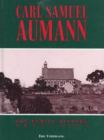
Book, Carl Samuel Aumann - The Family History 1853-1993, 1993
Hard cover book by Eric Uebergang. This book pays tribute to the Aumann pioneers in Australia and records details of their lives and those of their descendants to the year 1993, following a meeting of descendants in East Doncaster in 1992 and a family reunion in 1993 at the Lutheran Church in Doncaster, Victoria."Dedicated to the Memory of Carl Samuel Aumann, who with his family, made the arduous journey to Australia, to an unknown land. Known to the early German families of Doncaster as "Father" Aumann. Their hard work made the foundation for a prosperous country." Front cover: Bismark Street (Victoria Street), Doncaster. Lutheran Church and the home of Carl Aumann alongside the church. -
 Ringwood and District Historical Society
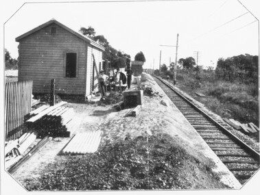
Photograph, Constructing Ringwood East railway station - 1925
Typed below one photograph, "Constructing Ringwood East railway station - 1925". Backing sheet of other photograph reads, "Ringwood East railway station - Higher than Croydon or Ringwood. Photo taken from Ringwood East railway station. Sub-division plan land sale Ringwood East Railway Station Estate 1925?" -
 Ringwood and District Historical Society
Newspaper, Scrapbook Clipping, Library Collection, Ringwood, Victoria
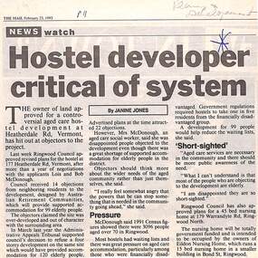
Newspaper Clipping from "The Mail", 23-2-1993. Hostel developer critical of system. Article by Janine JonesThe owner of land approved for a controversial aged care development at Heatherdale Rd, Vermont, has hit out at objectors to the project. Ringwood Council approved revised plans for the hostel at 177 Heatherdale Rd, Vermont, after a year of negotiations with the applicants, Lois and Bob McDonough. Council received 14 objections from neighbouring residents to the development. -
 City of Whittlesea
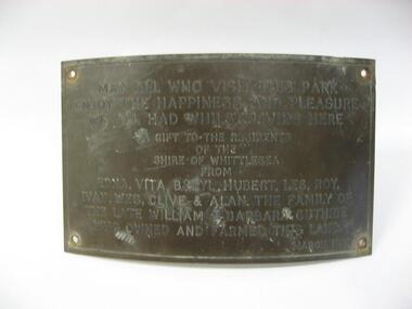
Plaque (item) - Norris Bank Reserve Plaque, Guthrie Family Plaque
May all who visit this park / enjoy the happiness and pleasure / we all had whilst living here / a gift to the residents / of this / Shire of Whittlesea / from / Edna, Vita, Beryl, Hubert, Les, Roy / Ivan, Wes, Clive & Alan the family of the late William & Barbara Guthrie / who owned and farmed this land / March 1981norris bank reserve -
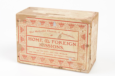 Uniting Church Archives - Synod of Victoria
Giving Box, Methodist Church of Australasia Home & Foreign Missions Giving Box, ?1930s - 1950s
Wooden giving box Front: "The Methodist Church of Australasia, Home & Foreign Missions. Go Ye Into All the World And Preach the Gospel to Every Creature". Top: "freely have Ye Received! Freely Give". Side 1: "Home Mission: To Spread Scriptural Holiness Through the Land". Side 2: "Foreign Mission: The Idols He Shall Utterly Abolish".methodist church of australasia home & foreign affairs -
![Fern Grove, near Mount Munday / [by] Nicholas Caire, circa 1876](/media/collectors/550653872162f11fb04854aa/items/57774d68d0cdd10a5c144296/item-media/57774e07d0cdd10a5c148099/item-fit-380x285.jpg) Kew Historical Society Inc
Kew Historical Society IncPhotograph, Anglo-Australasian Photographic Company, Fern Grove, near Mount Munday, c. 1876
Nicholas Caire was born on Guernsey in the Channel Islands in 1837. He arrived in Adelaide with his parents in about 1860. In 1867, following photographic journeys in Gippsland, he opened a studio in Adelaide. From 1870 to 1876 he lived and worked in Talbot in Central Victoria. In 1876 he purchased T. F. Chuck's studios in the Royal Arcade Melbourne. In 1885, following the introduction of dry plate photography, he began a series of landscape series, which were commercially successful. As a photographer, he travelled extensively through Victoria, photographing places few of his contemporaries had previously seen. He died in 1918. Reference: Jack Cato, 'Caire, Nicholas John (1837–1918)', Australian Dictionary of Biography, National Centre of Biography, Australian National UniversityAn original, rare photograph from the series 'Views of Victoria: General Series' by the photographer, Nicholas Caire (1837-1918). The series of 60 photographs that comprise the series was issued c. 1876 and reinforced a neo-Romantic view of the Australian landscape to which a growing nationalist movement would respond. Nicholas Caire was active as a photographer in Australia from 1858 until his death in 1918. His vision of the Australian bush and pioneer life had a counterpart in the works of Henry Lawson and other nationalist poets, authors and painters.Albumen silver photograph mounted on board‘The subject of this illustration is situated in one of the wildest and most romantic places in the Gipps Land ranges, about midway between Mount Munday and Mount Juliet. The foliage in this locality is very luxuriant, comprising mostly Fern Trees which are interwoven with various descriptions of grasses and stunted Fern leaves. Beneath this mass of vegetation flows a branch of the Contentment Creek.’landscape photography - victoria, nicholas caire, ferngrove - victoria -
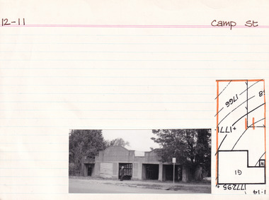 The Beechworth Burke Museum Research Collection
Card (Series) - Index Card, George Tibbits, Camp Street, Beechworth, 1976
George Tibbits, University of Melbourne. Faculty of Architecture, Building and Town & Regional PlanningIndex system that support the research for Beechworth : historical reconstruction / [by] George Tibbits ... [et al]Arranged by street names of BeechworthEach index card includes: street name and number of property, image of property, allotment and section number, property owners and dates of ownership, description of the property according to rate records, property floor plan with dimensions.beechworth, george tibbitsbeechworth, george tibbits -
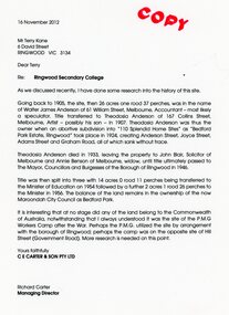 Ringwood and District Historical Society
Document - Folder, Brief history of the Ringwood Secondary College site in Bedford Road, Ringwood, Victoria, since 1905 and subdivision in 1924
Terry Kane and Richard Carter were the authors of the short historyType written notes and plans pertaining to the land titles and history of the Ringwood Secondary College site from 1905, prior to the land being sold by the Borough of Ringwood in 1954 to the Education Department. Transcript of covering letter from Richard Carter to Mr T Kane dated 16 November 2012 - "Re: Ringwood Secondary College As we discussed recently, I have done some research into the history of the site. Going back to 1905, the site, then 26 acres one rood 37 perches, was in the name of Walter James Anderson of 61 William Street, Melbourne, Accountant - most likely a speculator. Title transferred to Theodosia Anderson of 167 Collins Street, Melbourne, Artist - possibly his son - In 1907. Theodosia Anderson was thus the owner when on abortive subdivision Into "110 Splendid Home Sites" as "Bedford Park Estate, Ringwood" took place In 1924, creating Anderson Street, Joyce Street, Adams Street and Graham Road, all of which sank without trace. Theodosia Anderson died In 1933, leaving the property to John Blair, Solicitor of Melbourne and Annie Benson of Melbourne, widow, until title ultimately passed to The Mayor, Councillors and Burgesses of the Borough of Ringwood In 1946. Title was then spilt Into three with 14 acres 0 rood 11 perches being transferred to the Minister of Education on 1954 followed by a further 2 acres 1 rood 26 perches to the Minister In 1956. The balance of the land remains In the ownership of the now Maroondoh City Council as Bedford Park. It Is Interesting that at no stage did any of the land belong to the Commonwealth of Australia, notwithstanding that I always understood It was the site of the P.M.G. Workers Camp after the War. Perhaps the P.M.G. utilized the site by arrangement with the borough of Ringwood; perhaps the camp was on the opposite site of Hill Street (Government Road). More research Is needed on this point. Yours faithfully, CE CARTER & SON PTY LTD Richard Carter Managing Director" -
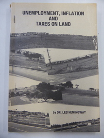 Warrnambool and District Historical Society Inc.
Book, Unemployment, inflation & taxes on land, 1982
This book details the problems caused by the low level of land tax in Victoria. It was written by Dr Les Hemingway who was a fitter and turner who studied medicine at the University of Melbourne and came to Warrnambool in 1958. He replaced Dr Etheridge in a Liebig Street practice. He retired in the mid 1990s. His book on the land tax question was influenced by the writings of the American journalist/philosopher, Henry George. This book is of interest as it was written in 1982 by Les Hemingway, a local Warrnambool doctor who practised in Warrnambool for over 30 years. This is a soft cover book of 152 pages. The cover is buff-coloured with a collage of black and white photographs on the front cover and a summary of the book on the back cover. There is black lettering on the cover and spine. The cover is a little torn and shows evidence of silverfish damage. The book is bound with three metal staples.economic history, history of warrnambool, dr les hemingway -
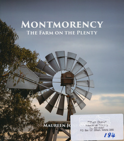 Eltham District Historical Society Inc
Book, Montmorency: The Farm on the Plenty by Maureen Jones, 2015
This book lays out the history of Montmorency from its earliest years as a hunting ground the Wurundjeri willam people, through its uptake by white settlers. Ownership of the land remained in the hands of one family for four generations spanning seventy years, before the land evolved through small farmlets into a suburb once part of the former Shire of Eltham, now part of Banyule City Council.Little has been written on the history of this hidden suburb of Melbourne. This book is significant in that it is the first major local history publication devoted to the suburb gathered particularly from local historical society archives and oral histories. ISBN 9780980807912montmorency -
 Rutherglen Historical Society
Document, 13/02/1998
When operational, the Gold Battery used cyanide in its processing processes. The land surrounding it required remediation before it could be handed over to Indigo Shire for public use. The land has since been planted with pasture and native plants. The Gold Battery has been restored to working condition, and can be viewed by collecting a ticket from the Rutherglen Wine Experience and Visitor Information Centre.Photocopy of letter relating to remediation works on the Gold Battery site.gold battery, gold processing, land remediation -
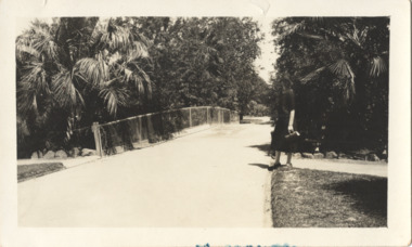 Kew Historical Society Inc
Photograph - In the 'Alexandra Gardens', Kew, 1927
The Alexandra Gardens in Cotham Road, Kew were opened by the Governor of Victoria in 1910. The first curator of the gardens was George Pockett, who with his brother is credited with the layout of the gardens. The gardens were constructed on land originally owned by the King family of 'Madford' in Wellington Street. The land on which the gardens were developed was originally the back paddock of 'Madford' which was purchased by the Borough of Kew in 1906.A rare and early photograph of the gardens showing clearly the changes to the layout and planting during the 1920s. Small, sepia coloured photographic positive of a woman standing beside a path and bridge in the Alexandra Gardens in Cotham Road, Kew.Annotation verso: "Alexandra Gardens Kew 1927"parks and gardens -- kew (vic.), alexandra gardens -- kew (vic.), george pockett -
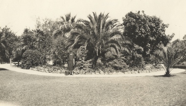 Kew Historical Society Inc
Photograph - In the 'Alexandra Gardens', Kew, 1927
The Alexandra Gardens in Cotham Road, Kew were opened by the Governor of Victoria in 1910. The first curator of the gardens was George Pockett, who with his brother is credited with the layout of the gardens. The gardens were constructed on land originally owned by the King family of 'Madford' in Wellington Street. The land on which the gardens were developed was originally the back paddock of 'Madford' which was purchased by the Borough of Kew in 1906.A rare and early photograph of the gardens showing clearly the changes to the layout and planting during the 1920s. Small, sepia coloured photographic positive of a woman with a suitcase standing on a gravel path in front of a semi-circular garden bed in the Alexandra Gardens in Cotham Road, Kew. The main plantings in the rock-bordered bed are varieties of palms. A wooden bridge can be seen to the woman's leftAnnotation verso: "Alexandra Gardens Kew 1927"parks and gardens -- kew (vic.), alexandra gardens -- kew (vic.), george pockett -
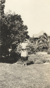 Kew Historical Society Inc
Photograph - In the 'Alexandra Gardens', Kew, 1927
The Alexandra Gardens in Cotham Road, Kew were opened by the Governor of Victoria in 1910. The first curator of the gardens was George Pockett, who with his brother is credited with the layout of the gardens. The gardens were constructed on land originally owned by the King family of 'Madford' in Wellington Street. The land on which the gardens were developed was originally the back paddock of 'Madford' which was purchased by the Borough of Kew in 1906.A rare and early photograph of the gardens showing clearly the changes to the layout and planting during the 1920s. Small, sepia coloured photographic positive of a woman standing on the grass in front of a garden bed in the Alexandra Gardens in Cotham Road, Kew. The Centennial Rotunda, built in 1910, can be seen in the background. Annotation verso: "Alexandra Gardens Kew 1927"parks and gardens -- kew (vic.), alexandra gardens -- kew (vic.), george pockett -
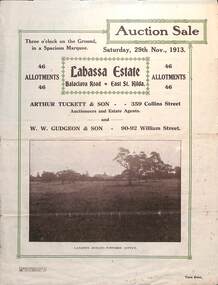 Melbourne Tram Museum
Ephemera - Real estate sale, Arthur Tucett & Son, "Labassa Estate" - Balaclava Road, East St Kilda, Nov. 1913
Pamphlet advertising the sale of land at the Labassa Estate, Balaclava Road 29-11-1913. Promotes the tram service, St Kilda Esplanade with a photo of PMTT 15 at the entry to Labassa at the corner of Orrong Road and Balaclava Road. Has a plan for the sub-division in to 46 allotments, terms of sale, and restrictions of what could be built on the land. The original Labassia Mansion is now owned by the National Trust.Demonstrates the style of land sale pamphlet including the availability of tram services to prospective purchasers.Pamphlet - folded - printed in two colours of cream coloured paper with photographs and plans.sale of land, trams, balaclava, balaclava road, real estate, labassa, orrong road -
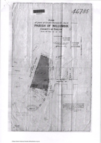 Eltham District Historical Society Inc
Document - Photocopy, Survey Fleld Notes of Part of Crown Portion 13, Section 4 at Eltham, Parish of Nillumbik, County of Evelyn, 7 May 1925
Portion of land bounded by: Main Road, Eltham Railway Station Application 46785 J.T. Robinson, Surveyor, 7 May 1925application 46785, arthur street, bible street, eltham, eltham railway station, luck street, main road, map, survey plan -
Glen Eira Historical Society
Document - Balaclava Road, 60, St Kilda East
Handwritten, undated, unattributed research notes briefly outlining the history of the land and house at Balaclava Road, 60, St Kilda East.balaclava road, orrong road, st kilda east, perrins james b, chaddesley, perrins elizabeth, andrew james b, sinclair sydney william, mordecai josh, mordecai clara, brosnan jean, johnston william, shawcross h m, shawross s, barrile s, pianella d -
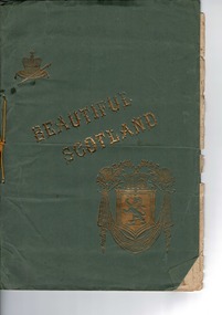 Lara RSL Sub Branch
Large Book, BEAUTIFUL SCOTLAND
Signed & dated 1916.Prefaced"a few examples of some of the famous,the beautiful,and the historicplaces for which this delightful land is so justly renowned.....The craftmanship in producing such a record of that time.Historic & Artistic significance.Surely rare therefore highly significant.LARGE "Portrait"slender book of views of SCOTLAND .Cover green cardboard pages aged cream .Gold embossing to front cover .Front Cover....Gold embossed title Beautiful Scotland ...COAT of ARMS DEPICTING LION RAMPENT ,ACROWN ,,ATARTAN&SCOTCH THISTLES.ALSO A CROWN ON ACUSHIONWITH A SCEPTRE . -
 Greensborough Historical Society
Letter - Poem, June Roberts, Poem by June Roberts, 1960c
Freeform poem protesting loss of amenity of river frontage land in Greensborough, for inclusion in Greenhills Progress Association newsletter, by June Roberts1 p. typed letter, by June M. Robertspoulter reserve greensborough, pope place greensborough, june roberts -
 Greensborough Historical Society
Photograph, Vacant land, Corner Wilson Avenue and Rattray Road Montmorency 1985, 1985_
A photograph of vacant land, Corner Wilson Avenue and Rattray Road Montmorency 1985, taken by Peter Graham, a Shire of Eltham Councillor.1 colour photograph.montmorency, peter graham, rattray road montmorency, wilson avenue montmorency -
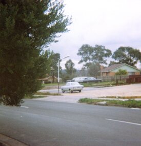
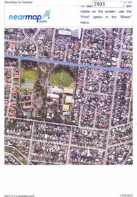 Greensborough Historical Society
Photograph, Nearmap.com, Nearmap: Greensborough, 27/09/2012
Aerial photographs of the Watsonia area, land owned by Black and Families, including sites of Loyola College, Loyola Reserve and Gresswell ReserveFour coloured aerial photographswatsonia, black family, loyola college, gresswell forest reserve -
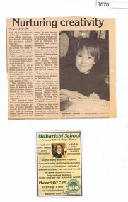 Greensborough Historical Society
Newspaper clipping, Diamond Valley Leader, Nurturing creativity, 17/12/1996
The Maharishi School was due to open in Bundoora in February 1997. This school was on the Loyola College site before Loyola acquired the building and land.Promotional article with photograph (17 December 1996), and advertisement (10 December 1996)transcendental meditation, maharishi school bundoora, loyola college -
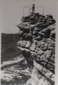 Halls Gap & Grampians Historical Society
Photograph - B/W
The Pinnacle Lookout with Fyans Valley below. Bellfield Hotel is visible in the lower left of the picture, cleared land is apparent in the middle of the picture.Man standing at a lookout on a rocky outcrop overlooking a valley. Guide rails surround part of the outcop. A mountain range is opposite.scenery, lookouts