Showing 11614 items matching "maps"
-
 Victorian Railway History Library
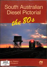
Book, Carter, Mark et al, South Australian Diesel Pictorial the 80s, 1990
A history of diesel locomotives on the Australian National network in South Australia in the 1980s.ill, maps, p.94.non-fictionA history of diesel locomotives on the Australian National network in South Australia in the 1980s.locomotives - south australia - history, diesel locomotives - commonwealth railways - australia -
 Monbulk RSL Sub Branch
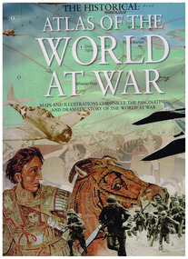
Book, B Lewis et al, Historical atlas of the world at war, 2009
The Historical Atlas of the World at War" details the history of war, from the tribal origins of war to the major world wars of the twentieth century. War has shadowed the whole of human history, featuring its greatest triumphs and greatest tragedies, and underlying all of it, the paramount need of all living things to survive.Ill, maps, p.400non-fictionThe Historical Atlas of the World at War" details the history of war, from the tribal origins of war to the major world wars of the twentieth century. War has shadowed the whole of human history, featuring its greatest triumphs and greatest tragedies, and underlying all of it, the paramount need of all living things to survive. war - history - maps, conflict - history -
 Monbulk RSL Sub Branch
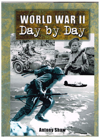
Book, Partworks Limited, World War II day by day, 2000
Illustrated and chronological history of the second world warIll, maps, p.192.non-fictionIllustrated and chronological history of the second world warworld war 1939-1945 - history, world war 1939-1954 - photographic record -
 Monbulk RSL Sub Branch
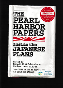
Book, Donald M. Goldstein, The Pearl Harbor papers, 1993
The Pearl Harborpapers finally reveals in all their details the original Japanese documents on Operation HawaiiIndex, maps, p.384.non-fictionThe Pearl Harborpapers finally reveals in all their details the original Japanese documents on Operation Hawaiipearl harbour attack, world war 1939-1945 - campaigns - pacific area -
 Victorian Railway History Library
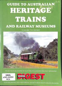
Book, Robert F. McKillop, Guide to Australian Heritage Railways & Museums Year 2000, 1999
A list of heritage railways and museums in Australia in 2000ills, maps, p.144.non-fictionA list of heritage railways and museums in Australia in 2000railway and tramway preservation - australia, tourist railways and museums - australia -
 Victorian Railway History Library
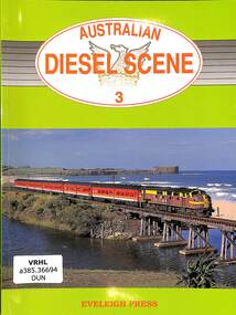
Book, Dunn, Ian et al, Australian Diesel Scene 3, 1994
Details of diesel locomotives working in Australia on government and private railways in the year 1994.ill, maps, p.120.non-fictionDetails of diesel locomotives working in Australia on government and private railways in the year 1994.diesel locomotives - australia - history, railroad operations - australia - history -
 Victorian Railway History Library
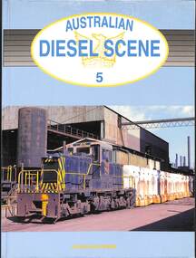
Book, Oberg, Leon et al, Australian Diesel Scene 5, 2002
Details of diesel locomotives working in Australia on government and private railways in the year 2002.ill, maps, p.152.non-fictionDetails of diesel locomotives working in Australia on government and private railways in the year 2002.diesel locomotives - australia - history, railroad operations - australia - history -
 Monbulk RSL Sub Branch
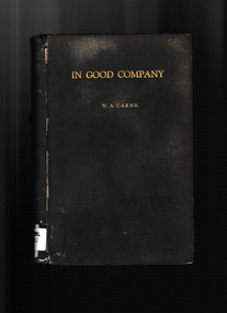
Book, 6th Machine Gun Company (A.I.F.) Association (Incorporating the 2nd Macine Gun Battalion), In good company : an account of the 6th Machine Gun Company A.I.F. in search of peace 1915-19, 1937
Regimental history of the 6th Machine Gun Company A.I.F.Ill, maps, p.424.non-fictionRegimental history of the 6th Machine Gun Company A.I.F. world war 1939-1945 - campaigns - france, world war 1914-1918 - regimental histories -
 Monbulk RSL Sub Branch
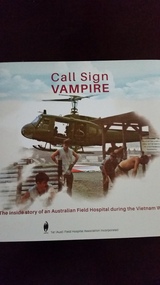
Book, 1st (Aust) Field Hospital Association Incorporated, Call sign vampire : the inside story of an Australian Field Hospital during the Vietnam War, 2021
This inside story of an Australian Field Hospital during the Vietnam War is told through a compilation of operational facts interspersed with the personal experiences of those who served and the patients who passed through the hospital doors, into their care.Call Sign VAMPIRE provides a window into the frenetic world of a military hospital in a war zone through evocative, sometimes confronting imagery. In this environment time was of the essence and life often hung in the balance.Ill, maps, p.280non-fictionThis inside story of an Australian Field Hospital during the Vietnam War is told through a compilation of operational facts interspersed with the personal experiences of those who served and the patients who passed through the hospital doors, into their care.Call Sign VAMPIRE provides a window into the frenetic world of a military hospital in a war zone through evocative, sometimes confronting imagery. In this environment time was of the essence and life often hung in the balance.vietnam conflict - australian involvement, 1st australian field ambulance -
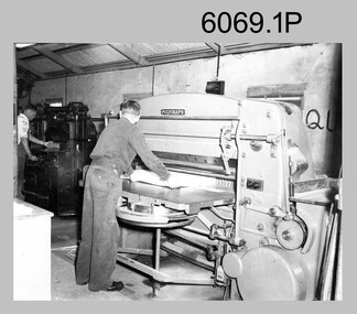 Bendigo Military Museum
Photograph - Printer Technicians trimming printed map stock at the Army Survey Regiment, c1960s to c1980s
These six photographs of Printer Technicians using a heavy-duty guillotine to trim bulk printed map stock were probably taken circa 1960s to 1980s in Lithographic Squadron at the Army Survey Regiment, Fortuna, Bendigo. Personnel are not identified on Photos .3P and .4P, however names are annotated on photos .1P, .2P, .4P and .5P. Cartographers normally provided trim marks to specified map dimensions as guidance to the printer. The trimming stage, like all the other printing processes required high levels of accuracy. These guillotines were extremely powerful to cut through bulk quantities of printed maps, as evident in photos .1P .3P, .4P and .6P.This is a set of photographs of Printer Technicians using a heavy-duty guillotine to trim bulk printed map stock c1960s to 1980s. The photographs were printed on photographic paper and are part of the Army Survey Regiment’s Collection. The photographs were scanned at 300 dpi. .1) - Photo, black & white, c1960s, L to R: ‘Wanger’ Payne, unidentified, Lithographic Squadron .2) - Photo, black & white, c1980s, CPL Ken Cavanagh, Lithographic Squadron .3) - Photo, black & white, c1970s, unidentified, Lithographic Squadron .4) - Photo, colour, c1970s, Peter Saunders, Lithographic Squadron .5) - Photo, black & white, c1980s, L to R: unidentified, WO1 Noel ‘Nesty’ Coulthard, Lithographic Squadron .6) - Photo, black & white, c1980s, unidentified, Lithographic Squadron.1P, .2P, .4P and .5P. personnel annotation on back. * unidentified on .1P due to poor writing. .3P and .6P – no annotationroyal australian survey corps, rasvy, army survey regiment, army svy regt, fortuna, asr, litho, printing -
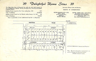 Ringwood and District Historical Society
Flyer, Subdivision advertisement for sale of home sites - Ringwood, Victoria - 1956
Cardboard-backed advertisement for 39 home sites for sale, with location map, and summary of local real estate statistics in 1955 & 1956. Handwritten date noted in top right corner - 24th March, 1956.Subdivision map includes Reilly Street, Philip Street, Lorienne Street and Daisy Street in Heathmont. Surveyors: Messrs Little and Brosnan. Agents in conjunction: Peter Martin Pty. Ltd., Estate Agents, 55-57 Latrobe Street, Melbourne (Phone) FB 3571, FB 2783, and Peter Aubin Pty. Ltd., Auctioneers & Estage Agents, 345 Lonsdale Street, Dandenong (Phone) Dandenong 340, after hours Dandenong 932, 70. -
 The 5th/6th Battalion Royal Victoria Regiment Historical Collection
Map, Britain and Underground Railways, July 1919
Used by Australian Soldiers whilst on leave after WW1.Reversible map made of paper. One side has a map of Britain and Ireland printed in colour, the other has a map of the London underground as well as several advertisements. there are small tears along the fold lines.wark vc club, regiment property -
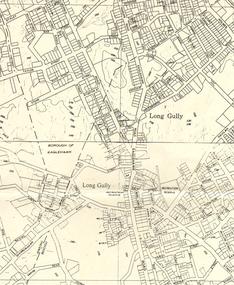 Bendigo Historical Society Inc.
Map - LONG GULLY HISTORY GROUP COLLECTION: MAP OF LONG GULLY AREA
BHS CollectionMap of Long Gully area printed on yellow paper. Map shows Eaglehawk Road from Don Street to Weatherall Street, then Mt Korong Road to Dowding Street. Some contour lines on the map.bendigo, history, long gully history group, the long gully history group - map of long gully area, borough of eaglehawk -
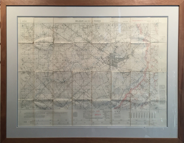 Tramways/East Melbourne RSL Sub Branch - RSL Victoria Listing id: 27511
Map and Legend, Trench Map - France Sheet 36 N.W
This is an actual battle map used by Australian Forces in the battle of the Somme in France in April 1917. It is an ordinance survey map of the trenches in the area. It is framed in two pieces, one being the main map and the other the legend used to read the map. It details the river 'La Lys Riviera' and the city 'Armentieres', in the Somme. somme, trench map, ww1, belgium, france, armentieres, 1917, ordinance survey map -
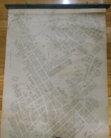 Bendigo Historical Society Inc.
Map - MAP: BENDIGO SHEET 2, 1910, 1910
Map. Map with timber ends, showing names of property owners. Bendigo from Olinda Street west to Prouses Road and Bennet / Wattle Street to Dooley Street in the north. Copy of map taken for research purposes. Map prepared by Department of Lands and Survey, Melbourne by T.F. McGauran 4.1.10 (1910)map, bendigo, residence areas, 1910 -
 Bendigo Historical Society Inc.
Map - GEOLOGICAL MAP OF BENDIGO GOLD FIELD
Two framed laminated maps (a,b) of Bendigo goldfield reef lines, map (b) is a continuation of the reef lines in map (a). On map(a) written in black on top: 'Geological Map, Bendigo Gold Field', Scale of chains, anticlines, synclines, shafts, alluvial and contours marked. Map (b) is continuation of (a). Written on the bottom RH corner of map: 'Prepared in 1923 in the Bendigo Office Mines Department under the direction of H. Herman, Director of Geological Surveys, from surveys by H.S. Whitelaw, Fiield Geologist, assisted by E.S. Usher & J. J. Moore. Re-issued in 1936.'H. Herman, Director of Geological Surveys, from surveys by H.S. Whitelaw, Fiield Geologist, assisted by E.S. Usher & J. J. Moore. Re-issued in 1936.'bendigo, mining, geological map. -
 City of Kingston
Pamphlet - Colour, W. H. Wood Estate Agent, Subdivisional Land Auction Barker's Estate Cheltenham, 1919
Sales plan for land in the suburb of Cheltenham, along Barker StreetThe developing urban area of Cheltenham within the City of Kingston. This land sale pamphlet illustrates the subdivision of land within the municipality and the changing demographic of the district as new houses are constructed.Colour pamphlet advertising subdivisional land auction of Barker's estate, on Barker Street Cheltenham.Handwritten in grey pencil on the subdivision map: a series of numbers on each block possibly indicating the sale price. Handwritten in grey pencil on the subdivision map: Roy- joined to subdivision 6 Handwritten in grey pencil on the subdivision map: x on the border between subdivision 17 and 16, and again on the border between subdivision 12 and 11.cheltenham, land sales, estate -
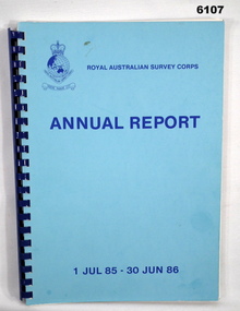 Bendigo Military Museum
Administrative record - Royal Australian Survey Corps Annual Report 1 Jul 85 - 30 Jun 86, DSvy - A, RASvy Corps, Report on activities 1 Jul 85 - 30 Jun 86, Circa 1986
The status of RASVY activities (for the dates shown) in field surveying, mapping and charting is given in this report and is shown pictorially in the Annexes to the reportBlue book, plastic ring binder, Map and Chart production 85-86, Annexes graphically depicting map productionroyal australian survey corps, rasvy, fortuna, army survey regiment, army svy regt, asr -
Greensborough Historical Society
Book, Melbourne Water, Plenty River Waterway Management Activity Plan 2000, 2000_
This report covers the catchment of the Plenty River from its upper reaches in the Great Dividing Range to the confluence with the Yarra River at Viewbank. It discusses ecological diversity and methods of improving water quality and significant areas of the catchment. Includes a brief history of settlement along the Plenty River.This is a significant plan for the improvement of the Plenty River.207 p., maps, folding maps. Printed on white paper with black spiral binding and clear plastic front cover.plenty river, melbourne water -
 Federation University Historical Collection
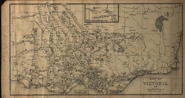
Map, Railway Map of Victoria, 1930
Cardboard map of Victorian railway system in 1930. Maps out all train-lines in Victoria and into New South Wales. map, railway, train-lines, victoria, victorian railways, railway lines -
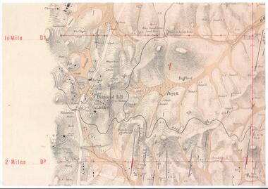 Bendigo Historical Society Inc.
Map - DIAMOND HILL AREA
Copy of map of Diamond Hill area, with the Trig Station mid centre on map. Shafts, mines and geological features are marked.bendigo, mining, diamond hill -
 Bendigo Historical Society Inc.
Map - JACK FLYNN COLLECTION: COUNTY OF GLADSTONE, 1934
Map: County of Gladstone, map sheet showing the whole of the County and the Parishes within. Scale 2 Miles to 1 inch.Engraved at the Department of Lands and Survey Melbourne. 1958. By Authority of W.M. Houston, Government Printermap, gladstone, parish plan, gladstone -
Bendigo Historical Society Inc.
Map - PART PARISHES OF SANDHURST MARONG AND NERRING, No date visible
Map: Section of a Parish plan of Bendigo, covering Ironbark, Eaglehawk and Myers Flat ( number 145 in Map Cupboard 1)map, bendigo, city streets, parish of sandhurst, parish of marong, parish of nerring, ironbark, eaglehawk, myers flat -
Bendigo Historical Society Inc.
Map - BENDIGO IRRIGATION SETTLEMENT, 12/02/1908
Map: Plan of Bendigo Irrigation Settlement, Parishes of Sandhurst and Wellsford, County of Bendigo ( number 160 in Map Cupboard 1)map, bendigo, irrigation settlement, bendigo irrigation settlement, parishes of sandhurst and wellsford, county of bendigo -
Bendigo Historical Society Inc.
Map - TOWNSHIP OF KANGAROO FLAT, 27/01/1932
Map: Township of Kangaroo flat, Parish of Sandhurst , County of Bendigo. Parish plan ( number 194 in Map Cupboard 1)map, bendigo, township, kangaroo flat -
Bendigo Historical Society Inc.
Map - BOROUGH OF EAGLEHAWK, 30/11/1931
Map: Borough of Eagle hawk, Parish of Nerring. Parish plan with coloured areas ( number 185 in Map Cupboard 1)map, bendigo, parish plan, borough of eaglehawk, parish of nerring -
Bendigo Historical Society Inc.
Map - TARNAGULLA (PARTS), Circa 1880's
Map: Compilation of 3 hand draughted parish plans showing portions of Tarnagulla (number 261 in map cupboard 1)map, parish plan, tarnagulla -
Bendigo Historical Society Inc.
Map - TOWNSHIP OF HEATHCOTE (PART), 11/04/1935
Map: Township of Heathcote (part), Parish of Heathcote, County of Dalhousie. Parish plan (number 259 in map cupboard 1)map, dalhousie, township, heathcote, copunty of dalhousie -
Bendigo Historical Society Inc.
Map - HUNTLY (PART) RESURVEY, Circa 1877
Map: Huntly [part) resurvey, Parish of Huntly, County of Bendigo. Parish plan ( number 243 in Map Cupboard 1)map, bendigo, parish plan, huntly -
Bendigo Historical Society Inc.
Map - PARISH OF EPPALOCK RESURVEY, 23/05/1876
Map: Parish of Eppalock resurvey, County of Bendigo, hand draughted Parish plan ( number 240 in Map Cupboard 1)map, bendigo, parish plan, eppalock, resurvey