Showing 25660 items
matching plenty-township-estate
-
 Whitehorse Historical Society Inc.
Article, Land Auction, Blackburn, 7/09/1994 12:00:00 AM
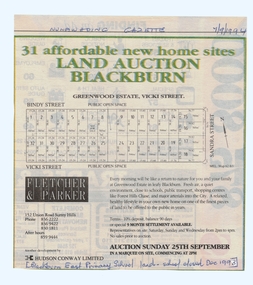
old Blackburn Advertisement in the Nunawading Gazette 7 September 1994Advertisement in the Nunawading Gazette 7 September 1994 for auction of the old Blackburn East Primary School (closed December 1993) land. Auction 25 September 1994. Greenwood Estate, Nicoli Street.old Blackburn Advertisement in the Nunawading Gazette 7 September 1994 land subdivision, bindy street, blackburn south, vicki street, sandra street, blackburn east primary school, no. 4800 -
 Bendigo Historical Society Inc.
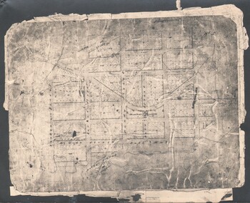
Map - TOWNSHIP OF LOCKINGTON, 21/09/1915
Map: Township of Lockington, Parish of Bamawm, County of Bendigo. Parish plan.Has a clipping from 'The Riverine Herald' dated 20/11/1915 on the reverse side re. the sale of blocks in Bamawm Township (number 322 in map cupboard 1)map, bendigo, township, lockington, bamawm, the riverine herald -
 Whitehorse Historical Society Inc.
Document, Land Brochures, 1929
Photocopies of sale brochures of land in Mitcham by Coghill & Haughton in conjunction with Drake & Co.Photocopies of sale brochures of land in Mitcham by Coghill & Haughton in conjunction with Drake & Co. Includes (a) General advertisement for Mitcham. (b) Station Front estate and Whitehorse Hill estate. (c) Detail of Station Front Estate. (d) Detail of Whitehorse Hill estate.Photocopies of sale brochures of land in Mitcham by Coghill & Haughton in conjunction with Drake & Co.mitcham, coghill & haughton, drake & co., the esplanade, auctions, walker, edgar edwardes, donald, station front estate, whitehorse hill estate, whitehorse road, mitcham road, barkly terrace, calcutta street, delhi street, benares street, simla street, land subdivision -
 Warrnambool and District Historical Society Inc.
Document, William Ellis Letters of Administration 1877, 1877
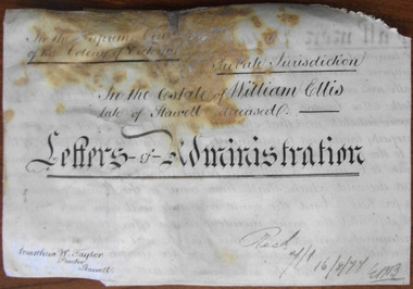
This is an 1877 document, the Letters of Administration in connection with the will and probate of William Ellis, a veterinary surgeon from Wimmera Street, Stawell. He died after an altercation with W. Richards, the landlord of the Post Office Hotel, where he was knocked against the wall of the verandah of the hotel. He left a small estate, with his property valued at under £107. This document is only of interest in that it came from the former legal offices of Mackay Taylor in Kepler Street, Warrnambool. It originally came from Thomas Goodall, a legal clerk in the office of lawyer Ernest Chambers who passed it on to George Mackay, the lawyer in the forerunner firm of Mackay Taylor where it remained until the firm of Mackay Taylor ceased to exist and the buildings were cleaned out. This is a piece of parchment folded and sealed at the bottom edge with a seal of the Supreme Court of the Colony of Victoria. The material in the document is handwritten in black ink. The document is stained and part of it is torn and missing. ‘In the Estate of William Ellis, late of Stawell, deceased, Letters of Administration, 16/8/77, Matthew W. Taylor, Proctor, Stawell’. william ellis,, stawell, warrnambool -
 Hume City Civic Collection
Photograph, c late 1980s
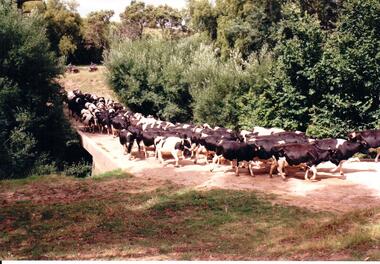
The series of photographs show a number of sites included in the Rupertswood Estate. By 1851 William Clarke had acquired 31,375 acres of land in the Sunbury district. The foundation stone for Rupertswood Mansion was laid on 29th August 1874 by Mrs. W. J. Clarke, daughter-in-law of 'Big Bull'. The Salesian Fathers bought the Rupertswood property in June 1927 and established Salesian College.A coloured photograph of a herd of Fresian cows crossing a small bridge on the Rupertswood Estate. The cows were from the agricultural studies faculty at Salesian College.rupertswood estate, clarke, william j. t. 'big bull', salesian brothers, george evans collection -
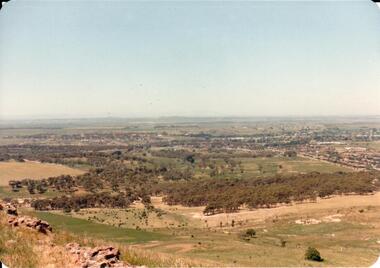 Hume City Civic Collection
Photograph, early 1980s
The Headland Estate housing development began in the early 1980s. It was situated west of Sunbury and was bounded by Elizabeth Drive, Reservoir Road, Phillip Drive and Stewart's Lane.A coloured landscape photograph with rounded corners of a view of Sunbury overlooking the Headland Estate before its development. There is a rocky outcrop on the LHS of the photograph and a lightly timbered area in the middle distance. Sunbury can be seen in the distance.headland estate, mt. holden, sunbury township, george evans collection -
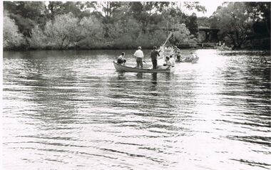 Bendigo Historical Society Inc.
Photograph - BERT GRAHAM COLLECTION: ANNUAL CLUB PICNIC
Photograph black & white, Bert Graham Collection, Annual Club Picnic 1961, Jubilee Lake, Daylesford.4 rowboats with about 5 people in each on the lake , plenty of trees lining the shore.bendigo, clubs, bendigo east swimming club -
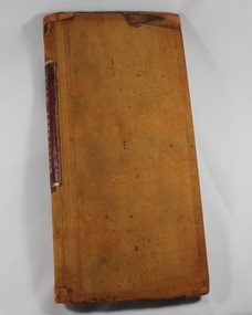 Deaf Children Australia
Book, Endowment Book 1873 - 1920
Created by the Victorian Deaf & Dumb Institution, this is a record of the estates, bequests, bonds and insurance policies of the VD&DI from 1873 to 1920This is a record of how the VD&DI obtained funds from various sources.Brown leather bound book with red leather on spine under name with marbelled facing pages on front and back covers. Pages are laid out in ledger format and detail estates, bequests, bonds and insurance policies of the V.D.&D.I.Spine: "ENDOWMENT BOOK" in gold stampingdeaf children australia, deaf education, endowment book -
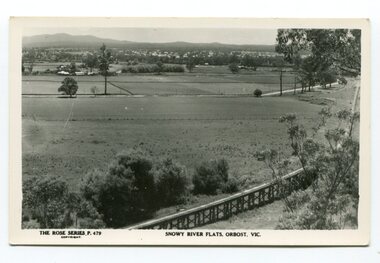 Orbost & District Historical Society
black and white photograph, Rose Stereograph Company, first half 20th century
The two bridges on the railway viaduct, which crosses the Snowy River floodplain at Orbost, were built from local Southern Mahogany. The bridge on the Bairnsdale end (770m) is now the longest in Victoria. Despite various attempts to extend the line, the station stayed on the western side of the Snowy River. (info. Helen Martin)This item is associated with the history of the Orbost-Bairnsdale railway line and therefore reflects the role that the rail line played in the social and economic history of Orbost.A black / white photograph / postcard of the Orbost township in the background and the railway viaduct over the flats in the foreground.photo caption - The Rose Series P.479 copywright SNOWY RIVER FLATS, ORBOST, VIC"east-gippsland-railway orbost-viaduct -
 Orbost & District Historical Society
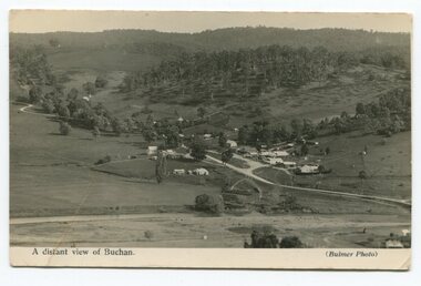
black and white photograph, Howard D. Bulmer, first half 20th century
This is a pictorial record of Buchan in the first half of the 20th century.A black / white photograph / postcard of a township in a valley. The photograph has been taken from a distance.on front - A Distant View of Buchanbuchan -
 Federation University Historical Collection
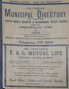
Book - Street Directory, Arnall & Jackson Pty Ltd, Victorian Municipal Directory and Gazatteer, 1939, 1939
Beige cover with blue spine. 1052 pages. It includes an index to townships, parishes and Railway stations. non-fictionvictorian municipalities, municipal, councils, water supply, advertisements, aboriginal protection board, agriculture, charities, county court, crown lands and survey, engine drivers board, licensing court, sludge abatement board, cities, towns, boroughs, ballarat, buninyong, gordon, grenville, talbot, traralgon, ballaarat, happy valley, bungaree, daylesford, glenlyon, glenlyon shire, hepburn springs -
Federation University Historical Collection
Book - Directory, Arnall & Jackson Pty Ltd, Victorian Municipal Directory and Gazatteer, 1935, 1935
Brown cover with maroon spine. 801 pages. It includes an index to townships, parishes and Railway stations. non-fictionvictorian municipalities, municipal, councils, water supply, advertisements, aboriginal protection board, agriculture, charities, county court, crown lands and survey, engine drivers board, licensing court, sludge abatement board, cities, towns, boroughs, ballarat, buninyong, gordon, grenville, talbot, traralgon, ballaarat, happy valley, bungaree, daylesford, glenlyon, glenlyon shire, hepburn springs -
Federation University Historical Collection
Book - Directory, Arnall & Jackson Pty Ltd, Victorian Municipal Directory and Gazatteer, 1924, 1924
Brown cover with blue spine. 708 pages. It includes an index to townships, parishes and Railway stations. non-fictionvictorian municipalities, municipal, councils, water supply, advertisements, aboriginal protection board, agriculture, charities, county court, crown lands and survey, engine drivers board, licensing court, sludge abatement board, cities, towns, boroughs, ballarat, buninyong, gordon, grenville, talbot, traralgon, ballaarat, happy valley, bungaree, daylesford, glenlyon, glenlyon shire, hepburn springs -
 Phillip Island and District Historical Society Inc.
Photograph
One of a collection of over 400 photographs in an album commenced in 1960 and presented to the Phillip Island & Westernport Historical Society by the Shire of Phillip IslandPhotograph of ladies and gentlemen on the Cowes Jetty taken looking along the trolley line towards the township.local history, photography, cowes jetty, black & white photograph, trolley line, cowes pier phillip island, john jenner, bryant west -
Glenelg Shire Council Cultural Collection
Postcard - Postcard - Suspension bridge Casterton, 1900-1930
SOURCED FROM CASTERTON TOWN HALL (FORMER SHIRE OF GLENELG) Sourced from Casterton Town Hall (Former Shire of Glenelg)Postcard, black and white,, showing the suspension bridge at Casterton, view across river towards townshipFront: 'SUSPN BRIDGE CASTERTON' Back: Handwritten correspondence, addressed to 'Miss M. Sythaleigh, Henty St Casterton' -
 Bendigo Historical Society Inc.
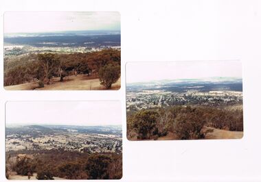
Photograph - CASTLEMAINE GAS COMPANY COLLECTION: PHOTO MALDON
3 photos of the township of Maldon taken from the tower located on Mt Tarrengower overlooking the town.Kodakplace, landscape view, maldon -
 Bendigo Historical Society Inc.
Photograph - WES HARRY COLLECTION: TOWNSHIP OF SANDHURST, 1854
Same photograph as the previous entry (2402.40). Written in biro on the reverse id: Township of Sandhurst 1854.place, bendigo, proposed township, sandhurst -
Bendigo Historical Society Inc.
Map - ELMORE, 7/08/1911
Map: Township of Elmore, Parish of Elmore, County of Bendigo ( number 159 in Map Cupboard 1)map, bendigo, township, elmore, county of bendigo -
Bendigo Historical Society Inc.
Map - GOORNONG, 1/10/1906
Map: Township of Goornong, Parish of Goornong, County of Bendigo ( number 154 in Map Cupboard 1)map, bendigo, township, goornong, county of bendigo -
Bendigo Historical Society Inc.
Map - HUNTLY, 7/01/1904
Map: Township of Huntly, Parish of Huntly, County of Bendigo ( number 150 in Map Cupboard 1)map, bendigo, township, huntly, parish of huntly, county of bendigo -
Bendigo Historical Society Inc.
Map - TOWNSHIP OF HEATHCOTE SHEET 2, Circa 1935
Map: Township of Heathcote sheet 2. Parish plan (number 254 in map cupboard 1)map, dalhousie, township, heathcote -
 Clunes Museum
Photograph
SEPIA PHOTOGRAPH OF CLUNES TOWNSHIP - showing Camp Hill and the Commercial Hotel. Mt Beckworth in distance. local history, photography, photographs, clunes township -
 Lakes Entrance Regional Historical Society (operating as Lakes Entrance History Centre & Museum)
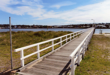
Photograph, 2008
Date made August 2008|This is the paired after photograph used in the 150 year Lakes Entrance 1858 - 2008 display.Colour photograph of the footbridge crossing Cunninghame Arm waterway, the township is in the foreground, Lakes Entrance, Victoria.bridges, waterways, township -
 Bendigo Historical Society Inc.
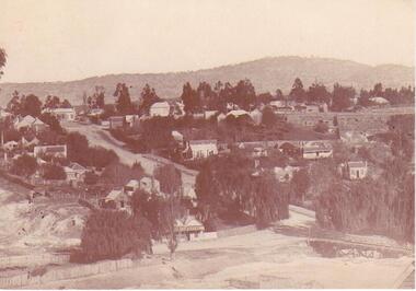
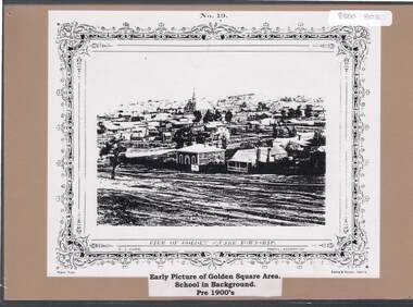
Document - GOLDEN SQUARE P.S. LAUREL ST. 1189 COLLECTION: PHOTO, 1900's
Copy of N.J. Caire print 'View of Golden Square township' mounted on light brown board.N.J. Caire, Photo Sandhurst. Forbes & Halmes, Agents.education, primary, golden square laurel st p.s., golden square township. -
 Kew Historical Society Inc
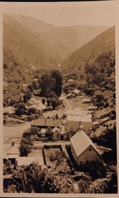
Postcard - Walhalla, 1920-25
Henry Christian (c.1809-91) was one of the first settlers in Kew. He arrived in Victoria with his wife Agnes and son Orlando in 1855 on the Gypsy Queen. He established a rope-making business in Bulleen Road by 1858 but was declared insolvent two years later. In his final years, he was celebrated as one of the oldest living settlers of the district. His son, Orlando Henry Beater Christian (c.1853-1930) became a member of the Hawthorn Band and a foundation member of the Willsmere Swimming Club. Orlando and his wife Elizabeth had four children: Henry Beater (1886-1962), Ada Susannah May (1888-1962), Orlando Julius (1891-1917) and Lilian Adelaide ( -1956).An item from an outstanding and diverse photographic collection, assembled by members of the Christian family of Pakington Street, Kew, comprising professional and amateur photography, depicting individuals, natural and settled environments and the interactions between these worlds. Many of the photographs vividly capture the worlds of three generations of men - Henry Christian, his son Orlando Henry Beater Christian, and his grandson of Henry Christian. The most important photographer was the youngest, Henry Christian, who was a keen explorer, not just of his immediate environment but also of the Victorian wilderness. His major opus is contained in two albums in which he records, sometimes in majestic detail and on other occasions the intimate features of the natural world. His photographic travels during the 1920s, often in solitary ramblings but on other occasions with companions, recall the heroic landscape photography of an earlier era, pioneered by Nicholas Caire. In addition to their aesthetic value, the albums are historically significant records within the State of Victoria, of what is now a distant point in time, and of places that have become radically altered through human intervention.Small sepia Kodak postcard of the Township of Walhalla, probably taken by the Kew photographer, Henry Christian. henry christian (1886-1962), landscape photography, walhalla -- victoria, christian-washfold collection -
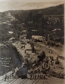 Kew Historical Society Inc
Postcard, M. Lee, First Train to Walhalla 15.3.1910, 1910
One of a number of 'real photo' and commercial postcards created by or owned by members of the Christian and Washfold families of Kew. The postcards are part of a larger collection of photographs, postcards and publications donated to the collection in May 2021.Small black and white postcard of the first train to Walhalla arriving in the township on 15 March 1910.First Train to Walhalla 15.3.1910. M. Lee Photohenry christian (1886-1962), landscape photography, trains -- walhalla -- victoria, christian-washfold collection -
 Sunbury Family History and Heritage Society Inc.
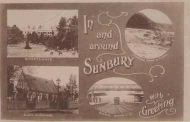
Post Card, In and around Sunbury with Greeting
The post card is one of a set that were produced by Chris Christainsen, who had a pharmacy in Sunbury and was also a photographer. The four photos featured on the card are the Rupertswood Mansion, St Mary's Church of England, Jacksons Creek in floods ands Sunbury Railway station.The buildings and places featured on the card are of historical significance in the Sunbury town precinct. A post card with four sepia photographs of interesting sites which can be seen in the Sunbury township. IN AND AROUND SUNBURY WITH GREETING. christainsen, chris., rupertswood mansion, st. mary's church of england., jacksons creek, sunbury railway station -
 Warrnambool and District Historical Society Inc.
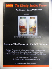
Document, Glenelg Auction catalogue K T Swinton, 2014
This catalogue contains a list of the sale items of Mr Keith T Swinton. The Swinton family are long time residents of Warrnambool the family originally coming from Scotland in 1854 and opening the store in Timor Street Warrnambool. It remains today as one of the longest running family owned businesses in the district. As a general store it stocked groceries china,glass and hardware.. Keith Swinton joined the family firm with his brother Frank in 1934. Much of the original store was relinquished in the 1970's with the furniture section continuing under the Swinton name to this day.This catalogue contains the collection of household items.An interesting item which shows the collection of one of Warrnambool's residentsMainly black soft card cover with red and white text and coloured photograph of a pair of vases.Back cover is black with red line at the top edge with coloured photograph in centre of auction item .18 pages of the catalogue gives a description of the 600 items and estimated price. Inside front and back covers are coloured photgraphs of some of the items for sale.Account the Estate of Keith T Swintonwarrnambool, swinton, keith t swinton -
Kew Historical Society Inc
Flyer - 45 Pakington Street, Kew
Subdivision plans and real estate flyers/brochures reveal a number of aspects of urban development and history. The Kew Historical Society's collection of these plans, as well as advertisements extracted from magazines, cover key aspects of community development and architectural history of Kew and Kew Eat as well as surrounding suburbs. While most of the plans in the collection were gifted to the Society by the former City of Kew, a number of other plans and advertisements have been donated by individuals, of which this is an example.Single page illustrated real estate flyer advertising 45 Pakington Street, Kew for sale by auction. Annotation in pen and ink at rightpeter neville, real estate advertisements -- kew (vic.), 45 pakington street -- kew (vic.) -
 Kew Historical Society Inc
Photograph - 8 roomed DF Brick Villa, Kew, J E Barnes, c.1920
Subdivision plans are historically important documents used as evidence of the growth of suburbs in Australia. They frequently provide information about when the land was sold on which a built structure was subsequently constructed as well as evidence relating to surveyors and real estate and financial agents. The numerous subdivision plans in the Kew Historical Society's collection represent working documents, ranging from the initial sketches made in planning a subdivision to printed plans on which auctioneers or agents listed the prices for which individual lots were sold. In a number of cases, the reverse of a subdivision plan in the collection includes a photograph of a house that was also for sale by the agent. These photographs provide significant heritage information relating house design and decoration, fencing and household gardens. The photograph is of additional aesthetic significance as it was photographed by J. E. Barnes. Josiah Earl Barnes is a nationally significant photographer. He was also the most important photographer to have worked in Kew. He was active as a photographer in the district from c.1906 until his death in 1921. Best known as 'the Embarkation Photographer' (see the Australian War Memorial collection), J. Earl Barnes was also the official photographer employed by the Borough (and later Town, then City) of Kew. He clearly also completed commercial jobs for local businesses, as is the case in this photograph of a house for a local real estate and financial agent.A photograph, mounted on board of a double fronted Federation-era brick villa in Kew, photographed for a local real estate agent and financier by J. E. Barnes of Kew. On the reverse of the photograph is a subdivision plan for the Normanby Estate, East Kew - 2016.0039.1. As can be seen from the image, there is a large tear on the surface of the photograph.The brown card on which the photograph is mounted includes the following handwritten description, which may aid the identification of the house: "Kew, 3 minutes from tram, 8 roomed DF Brick Villa, tile roof including two attics, sleepout, bathroom, heater, E Light, Entrance Hall, double doors, leadlights, laundry, garden, lawns, land 75 x 170, 1975 pounds". Also photographers inscription on mount, lower left: J. E. Barnes / Photo / Phone 1966 Haw. KEW.j. e. barnes, josiah earl barnes, j. earl banes - photographer, architecture - federation style, houses - kew, real estate photographs