Showing 4549 items matching "historical map"
-
 Bendigo Historical Society Inc.
Map - DERBY, No date visible
Map: Derby. Hand draughted parish plan (number 303 in map cupboard 1)map, bendigo, parish plan, derby -
Bendigo Historical Society Inc.
Map - EPPALOCK, COUNTY OF BENDIGO MAP, 3/11/1882
Map: Eppalock, County of Bendigo. Parish plan (number 302 in map cupboard 1)map, bendigo, parish plan, eppalock -
Bendigo Historical Society Inc.
Map - NEILBOROUGH, 15/10/1877
Map: Neilborough, County of Bendigo. Parish plan (number 301 in map cupboard 1)map, bendigo, parish plan, neilborough, elysian flat -
Bendigo Historical Society Inc.
Map - LEICHARDT, Circa 1870's
Map: Leichardt, Hand draughted parish plan ( number 300 in map cupboard 1 )map, bendigo, parish plan, leichardt -
 Bendigo Historical Society Inc.
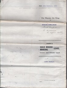
Document - MCCOLL, RANKIN AND STANISTREET COLLECTION: NAPOLEON REEF GOLD MINING CO. N.L, 18 Feb 1941
Document: 4 Page legal document with map of lease area issued to William James Moore of Bendigo, Lease No. 11064 Bendigo, Vol. 325 Fol. 35881 County of Bendigo Parish of Sandhurst, 15 year lease from 18th February 1941, in vacinity of Curnow St, Booth St, Maple St and Rowan Sts, Lease by South Napoleon to be allowed to lapse in 1942, signed by Major General Sir Winston Joseph Dugan Governor of Victoria, William James Moore & witnessed by Walsh, Wardens Clerk Bendigo.organization, business, industrial - mining, mccoll rankin & stanistreet, mining, gold mining, napoleon reef -
Bendigo Historical Society Inc.
Map - JANIEMBER EAST, No date visible
Map: Janiember East, Hand Draughted? Parish plan (number 299 in map cupboard 1)map, bendigo, parish plan, janiember east , serpentine -
Bendigo Historical Society Inc.
Map - COUNTRY LANDS, 4/06/1874
Map: Country lands, Parishes of Goornong, Egerton, Elmore and Nolan, County of Bendigo. Parish plan (number 298 in map cupboard 1)map, bendigo, country lands, country lands, goornong, elmore, egerton, nolan -
 Bendigo Historical Society Inc.
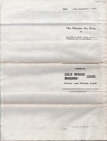
Document - MCCOLL, RANKIN AND STANISTREET COLLECTION: NAPOLEON REEF GOLD MINING CO. N.L, 22 August 1950
Document: 5 Page legal document with map of lease area, Lease No. 11273 Bendigo, Vol.331, Fol. 36453, 15 year lease from 12 December 1949, in vicinity of Inglis, Harvey & Curnow Streets, Signed by Dallas Brooks, Gov of Victoria & J.J. Stanistreet, Mine Manager.organization, business, industrial - mining, mccoll rankin & stanistreet, mining, gold mining, napoleon reef -
Bendigo Historical Society Inc.
Map - AXEDALE, 10/10/1904
Map: Axedale, Counties of Bendigo and Rodney. Parish plan (number 297 in map cupboard 1)map, bendigo, parish plan, axedale -
Bendigo Historical Society Inc.
Map - MANDURANG 2, March 194-?
Map: Mandurang 2, County of Bendigo. Parish plan (number 296 in map cupboard 1)map, bendigo, parish plan, mandurang -
Bendigo Historical Society Inc.
Map - MANDURANG 1, March 1947
Map: Mandurang 1, County of Bendigo. Parish plan (number 295 in map cupboard 1)map, bendigo, parish plan, mandurang -
Bendigo Historical Society Inc.
Map - HAYANMI, 16/05/1879
Map: Hayanmi, County of Bendigo. Parish plan (number 294 in map cupboard 1)map, bendigo, parish plan, hayanmi -
Bendigo Historical Society Inc.
Map - REDCASTLE, 15/10/1878
Map: Redcastle, County of Rodney. Parish plan. (number 293 in map cupboard 1)map, rodney, parish plan, redcastle -
Bendigo Historical Society Inc.
Map - WESTON RESURVEY, June 20th 1875
Map: Weston, Resurvey.Hand draughted Parish plan (number 292 in map cupboard 1)map, parish plan, weston -
Bendigo Historical Society Inc.
Map - STRATHFIELDSAYE, 25/06/1877
Map: Strathfieldsaye, County of Bendigo. Parish plan (number 291 in map cupboard 1)map, bendigo, parish plan, strathfieldsaye -
Bendigo Historical Society Inc.
Map - PARISHES OF WARRAGAMBA AND MINTO, No date visible
Map: Parishes of Warragamba and Minto,Hand draughted parish plan. (number 290 in map cupboard 1)map, parish plan, warragamba, minto -
Bendigo Historical Society Inc.
Map - HUNTLY ALLOTMENTS, No date visible
Map; Huntly Allotments, County of Bendigo. Parish plan (number 289 in map cupboard 1)map, bendigo, allotments, huntly allotments -
Bendigo Historical Society Inc.
Map - KAMAROOKA ALLOTMENTS, 7/06/1894
Map: Parish of Kamarooka Allotments, County of Bendigo. Parish plan (number 288 in map cupboard 1)map, bendigo, allotments, kamarooka, allotments -
Bendigo Historical Society Inc.
Map - KAMAROOKA STATE FOREST, 23/11/1910
Map: Part of Subdivision of kamarooka State Forest, Parishes of Neilborough and Whirrakee, County of Bendigo. Parish plan (number 287 in map cupboard 1)map, bendigo, subdivision, kamarooka state forest, subdivision, whirrakee -
Bendigo Historical Society Inc.
Map - PARISH OF MARONG ALLOTMENTS, No date Visible
Map: Parish of Marong Allotments, County of Bendigo. Parish plan Blueprint (number 286 in map cupboard 1)map, bendigo, allotments, marong allotments -
Bendigo Historical Society Inc.
Map - RUNNYMEDE, 2/05/1895
Map: Runnymede, County of Rodney. Parish plan (number 285 in map cupboard 1)map, rodney, parish plan, runnymede, county of rodney -
Bendigo Historical Society Inc.
Map - NOLAN, 5/03/1888
Map: Nolan, County of Bendigo. Parish plan (number 284 in map cupboard 1)map, bendigo, parish plan, nolan -
Bendigo Historical Society Inc.
Map - MINTO, /01/1884
Map: Minto, County of Bendigo. Parish plan (number 283 in map cupboard 1)map, bendigo, parish plan, minto -
Bendigo Historical Society Inc.
Map - PANNOOMILLOO, 21/06/1882
Map: Pannoomilloo, County of Bendigo. Parish plan (number 282 in map cupboard 1)map, bendigo, parish plan, pannoomilloo -
Bendigo Historical Society Inc.
Archive - MCCOLL, RANKIN AND STANISTREET COLLECTION: NAPOLEON REEF MINING BOX
Mining Box: metal box, painted dark blue, formerly box number 489 - Now Napoleon Reef Mining Box 5. Tag affixed to front ' box 489' Printed on door in white paint ' Napoleon Reef'. Box contains various documents relating to Napoleon Reef Mine. Documents are individually catalogued within box.mining, parish map, mccoll, rankin & stanistreet, mccoll rankin & stanistreet, mining, gold mining, napoleon reef -
Bendigo Historical Society Inc.
Map - PARISH OF WHIRRAKEE, Surveyed 14/07/1904
Map: Parish of Whirrakee. Hand Draughted Parish plan (number 280 in map cupboard 1)map, bendigo, parish plan, whirrakee -
Bendigo Historical Society Inc.
Map - ROCHESTER WEST, 22/12/1881
Map: Rochester West, County of Bendigo. Parish plan (number 279 in map cupboard 1)map, bendigo, parish plan, rochester west -
Bendigo Historical Society Inc.
Map - LYELL, 4/06/1873
Map: Lyell. Parish plan (number 278 in map cupboard 1)map, bendigo, parish plan, lyell -
Bendigo Historical Society Inc.
Map - FOSTERVILLE MAP, 19/08/1897
Map: Township of Fosterville, Parish of Ellesmere, County of Bendigo. Parish plan (number 277 in map cupboard 1)map, bendigo, township, fosterville, ellesmere -
Bendigo Historical Society Inc.
Map - BRIDGEWATER, 10/09/1913
Map: Bridgewater, Parishes of Bridgewater and Inglewood, Counties of Bendigo and Gladstone (number 276 in map cupboard 1)map, bendigo, parish plan, bridgewater