Showing 10781 items
matching a lake
-
 Lakes Entrance Regional Historical Society (operating as Lakes Entrance History Centre & Museum)
Photograph, 1930c
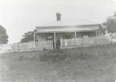
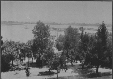
Cliff Crest Tea Rooms / Scone Cottage / Boarding House was conducted by Mrs Westerson for many yearsBlack and white photograph of Cliff Crest Tea Rooms at Nungurner, Gippsland Lakes. It shows weatherboard dwelling with hipped iron roof, veranda across front with guests posing for camera. White picket fence and seating at front of building. Lakes Entrance Victoriaislands, accommodation -
 Lakes Entrance Regional Historical Society (operating as Lakes Entrance History Centre & Museum)
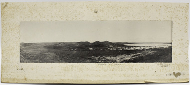
Photograph, 1910c
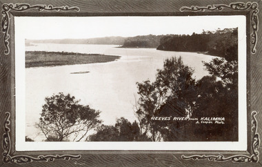
Also another copy print 8 x 13, both printed as though framedBlack and white photograph of Reeves Channel, Gippsland Lakes. It shows Rigby Island opposite the steep cliffs of mainland shore. Small island off Rigby was known as the Doughboy. Taken from Jemmys Point, natural vegetation in foreground. Lakes Entrance VictoriaReeves River from Kalimnaislands, waterways, topography -
 Lakes Entrance Regional Historical Society (operating as Lakes Entrance History Centre & Museum)
Photograph, 1900
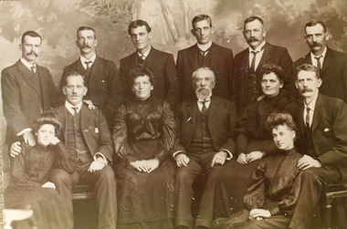
Sepia toned photograph of thirteen members of the Coate family Tom, Dave, Arthur, Ned, Joe, Mary, Jade, grandfather Lou, George, Lily. Some in photograph being members of Coate Brothers contractors for strenthening the Lakes piers, Lakes Entrance Victoriagenealogy -
 Lakes Entrance Regional Historical Society (operating as Lakes Entrance History Centre & Museum)
Photograph, 1999
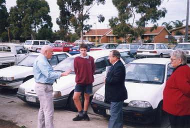
Colour photograph of student David Kelly and three adults Henrie Ellis - Principal LESC, David Klemm - KAB committee, Margaret Daly - KAB local co-ordinator in car park on visit to Lakes Entrance Secondary College, Lakes Entrance Victoriaschools -
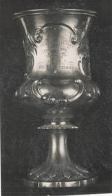 Phillip Island and District Historical Society Inc.
Photograph
One of a collection of over 400 photographs in an album commenced in 1960 and presented to the Phillip Island & Westernport Historical Society by the Shire of Phillip IslandPhotograph of the Silver Cup won by A. Morrison as Victorian Ploughman Champion 1859.Burrumbeet & Lake Learmonth Agricultural Society. Ploughing 1st Prize awarded to Mr. A. Morrison. Annual match Victoria 1859.local history, photography, silver cup, ploughing award, black & white photograph, ploughing, competitions, a morrison, john jenner, bryant west -
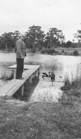 Ringwood and District Historical Society
Photograph, Mr. A.V. McArthur at Ringwood Lake. (RSL President throughout the war years). (undated)
Mr. A.V. McArthur, 'The Man in Grey'. President of the Ringwood R.S.L. throughout the war years. This picture taken at Ringwood Lake. -
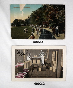 Bendigo Military Museum
Postcard - POSTCARDS, (.1) 24.10.1917
(.1) The letter to Lena is unsigned but is obviously from Britain. The only names mentioned are Cliff, Fred Mann. (.2) The postcard on the rear has the details of “LEGGO’s” High and Short streets Bendigo. These are part of a collection of postcards and photos relating to “Lena”. Refer Cat No 3996P for “Lena” details and other cards. (.1) Postcard, colour with scene along a small canal with people walking along side. On the rear is a letter in pencil addressed to “Dear Lena”. (.2) Post card, colour showing two men in a factory setting preserving fruit. (.1) On the front “Children’s ......... Bournemouth” (.2) On the front “LEGGO’s preserving raspberries right in the orchard at Mountain Glen King Lake”postcards, lena, scenes -
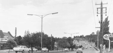 Ringwood and District Historical Society
Photograph, Maroondah Highway East, Ringwood- 1971. Looking east towards Mt Dandenong Road
Black and white photographWritten on back of photograph: "Maroondah Highway, looking east towards Mt Dandenong Road turnoff past lake. 1971." -
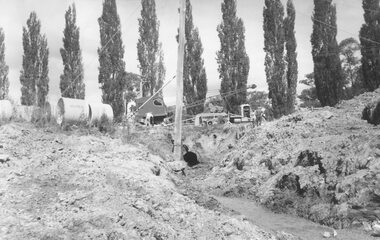 Ringwood and District Historical Society
Photograph, Maroondah Highway East, Ringwood- 1963. Excavations for Ringwood Lake overflow
Black and white photograph (2 copies- 1 large, 1 smaller)Typed on rear of backing sheet of large photograph: "Ringwood lake overflow pipe. (Passing under Maroondah Highway). 1963. -
 The Beechworth Burke Museum
Photograph, Unknown
Aerial view of Lake Sambell, Beechworth with town views. Lake Sambell is a beautiful Victorian recreation lake and urban park with a unique history. It was created in the mid-1800s by the Rocky Mountain Mining company during the gold rush era and used as a mining site until the early 1900s, which brought Europeans into the area. It was turned into a reserve for residents in 1920 and is considered an icon of Beechworth as it represents the development of the community, human endeavour, and the spirit of the landscape.This photograph represents Lake Sambell with town views.Black and white reproduced rectangular photograph print on paper.Reverse: Stampbeechworth lake, lake sambell, aerial photo, construction, australian landscape, #beechworth, victoria -
 Robin Boyd Foundation
Document - Script, Robin Boyd, The Flying Dogtor. Episode 46 Deep Secret, 1963
The Flying Dogtor was exploring by submarine, the depths of a lake in the Snowy Mountains area, looking for a giant sea-serpent or lake monster, which seemed to be threatening the Snowy Scheme. He found an old township that had been submerged in the water and he saw signs that the monster was close by. Suddenly, the submarine was knocked up and over from behind. Then it dived down and down into the mud of the bed of the lake, trapping its brave occupant, The Flying Dogtor.The Flying Dogtor" series was broadcast on Australian Television Network (later becoming the Seven Network) between February and April 1964 (see item D254 for schedule).Typewritten, carbon copy, foolscap, 2 pagesHandwritten pencil edits and additions.the flying dogtor, robin boyd, crawford productions, manuscript -
 Stawell Historical Society Inc
Photograph, Snow Scene at Lake Bellfield at Halls Gap 1981
Snow Scene Lake Bellfield Grampians June 1981stawell -
 Port Fairy Historical Society Museum and Archives
Photograph, Tower Hill Koroit, unknown
Panoramic mounted photograph of Tower Hill Volcano with lake.Interesting photograph of Tower Hill before extensive re-vegetation works carried out in the 1960s.Panoramic landscape black and white photograph of Tower Hill, Koroit. Mounted black and white photograph on card, rectangular.? Aberline, 26 Faversham R?, Canterbu? On back of card mount Fred Rogersvolcanoes, tower hill -
 Stawell Historical Society Inc
Photograph, Stawell Field Naturalists at Lake Lonsdale -- 5 Photos -- Coloured
Stawell Field Naturalists – Lake Lonsdale Five photographs.stawell -
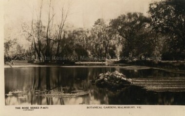 Malmsbury Historical Society
Postcard (Item), "Postcard Botanical Gardens Malmsbury, Rose Series P4671", Malmsbury c1927
Associated with - Rose Series P4671 Buildings - "Gardens, Lake" -
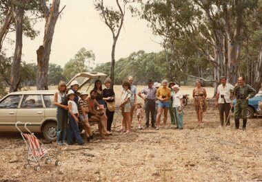
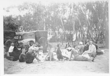 Stawell Historical Society Inc
Photograph, Bradley & Johnston Families picnicing at Lake Lonsdale 1935
Picnic at Lake Lonsdale - Bradley & Johnston Families 1935stawell -
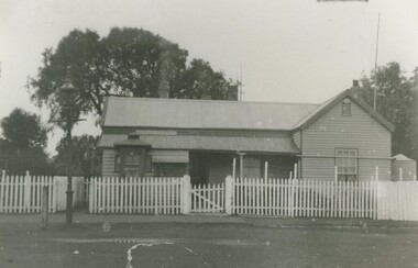 Lake Bolac & District Historical Society
Black and white photo, Lake Bolac Post Office, 1919
Lake Bolac Post Office, original building, 1919.lake bolac, posr office, 1919 -
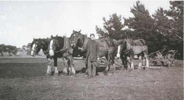 Lake Bolac & District Historical Society
Black and white photograph, Vic Peters of Lake Bolac with Horse-team and plough
Vic Peters of Lake Bolac with horse-team and plough -
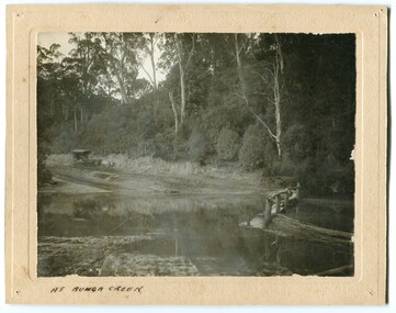 Orbost & District Historical Society
black and white photograph, late 19th - early 20th century?
Bunga Creek is approximately 5km east of Lakes Entrance.This is a pictorial record of horse-drawn transport of the late 19th century used in East Gippsland.A black / white photograph of a bush scene with a horse - drawn coach running along a track beside a creek.. It is on a cream coloured buff card.on back - "No. 5" on front - "At Bunga Creek"bunga-creek horse-drawn-coach -
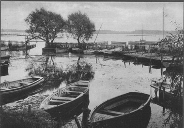
 City of Ballarat Libraries
Photograph, Steamer Landing Wharf, Lake Wendouree circa 1930
Steamer landing wharf on the western side of Lake Wendouree.lake wendouree, steamer -
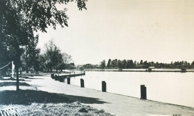
 City of Ballarat Libraries
Photograph, Boat Harbour, Lake Wendouree circa 1890s
The boat harbour on Lake Wendouree was situated on the eastern side.lake wendouree, rowing, ballarat, harbour, entertainment -
 City of Ballarat Libraries
Photograph, View of Lake Wendouree from Fry's Mill circa 1890s
This view from Fry's Mill is of the eastern side of the lake.lake wendouree, fry's mill, ballarat -
 Stawell Historical Society Inc
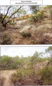
Photograph, Quarry in the Grampians -- Stone used for Lake Fyans Emabankment 2017
Quarry in Grampians Stone used for Lake Fyans Wallstawell -
 Stawell Historical Society Inc
Photograph, View across Lake Lonsdale Spillway Looking North
View across Lake Lonsdale Spillway Looking Northstawell -
Stawell Historical Society Inc
Photograph, View of spillway at Lake Lonsdale
View of spillway Lake Lonsdale. House possibly Scoullar stawell -
Lakes Entrance Regional Historical Society (operating as Lakes Entrance History Centre & Museum)
Photograph, Elite Photos Melbourne
Photograph sent to Nan Fraser of Lakes Entrance VictoriaSepia toned photograph of Beth Rule and Leigh Cox taken as they were leaving the wedding ceremony Melbourne VictoriaVery Many Thanks. We send our warm appreciation of your Good Whishes and Thoughtful Giftcelebrations, fashion -
 Lakes Entrance Regional Historical Society (operating as Lakes Entrance History Centre & Museum)
Photograph, 1992
Appeared in Lakes Post Newspaper 21 October 1992.Black and white photograph of local residents at the ceremony held in the Kalimna West Hall to mark the closure of Kalimna West Primary School. Kalimna West Victoriaschools -
 Orbost & District Historical Society
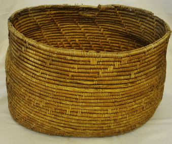
basket, Untitled, second half 19th century
Made as wedding present for Cameron, John (Mrs) in 1880 at Lakes Entrance. John Cameron (1847-1930) selected first land on Snowy River flats. Married Elizabeth Roadknight (1863-1939) who was born in Cunninghame (now Lakes Entrance).This item is associated with the Cameron family who were early Orbost settlers.Large handmade woven Aboriginal basket.basket household basket-woven aboriginal lakes-entrance cameron-john -
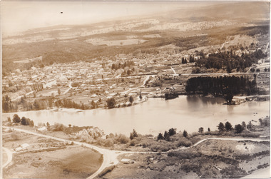 The Beechworth Burke Museum
Photograph, 1960
Taken in 1960, depicted is an aerial view of Lake Sambell and the surrounding township. Lake Sambell is a beautiful Victorian recreation lake and urban park with a unique history. It was created in the mid-1800s by the Rocky Mountain Mining company during the gold rush era and used as a mining site until the early 1900s, which brought Europeans into the area. It was turned into a reserve for residents in 1920 and is considered an icon of Beechworth as it represents the development of the community, human endeavour, and the spirit of the landscape.This photograph represents what Lake Sambell looked like in 1960.Black and white reproduced rectangular photograph print on paper.lake sambell, #beechworth, beechworth 1960s, lake, victoria, australian landscape, mining, rocky mountain mining company -
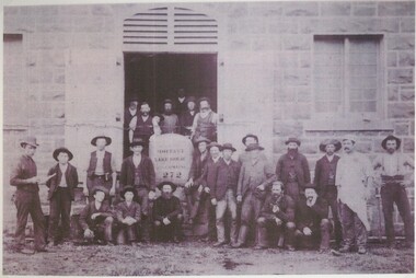 Lake Bolac & District Historical Society
black & white photograph, The Woolshed, Lake Boloke Station, 1894
The Woolshed of Lake Boloke Station, 1894. The woolshed was built by Robert Patterson but at this time was owned by the Moffat family. Identified persons in the photograph are Neil Graham, Dave Sago (with beard, seated centre) and Bill Pitkethly. "Boloke" is a local aboriginal word meaning 'lake'.lake boloke station, woolshed, patterson, moffat, graham, sago, pitkethly