Showing 6697 items
matching river
-
 Greensborough Historical Society
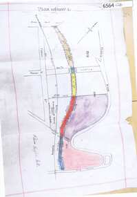
Map, Poulter Avenue transverse, 1900 c
This is a survey of land acquired from William Haylock Poulter for the construction of Poulter Avenue. Includes area of River Estate and part of Poulter Reserve, Carter Street, Flintoff Street and Plenty River.1 p. photocopy of traverse survey printed in colourSigned by William Haylock Poulterpoutlter avenue greensborough -
 Bendigo Military Museum
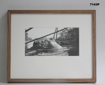
Photograph - PHOTOGRAPH, FRAMED WW1, Wayne Eels, C.2008/2009
The Grinton Collection. Life after 1919, shows an irrigation system. Refer Cat No 1280 for Jack Grintons service details.Photograph - Framed. Photograph - black and white photograph on paper depicting a pump outlet gushing water into an irrigation system. Background - river and trees. Frame - Timber, light varnish finish, Perspex front, cardboard backing."Group 6: Life after 1919". "L. Irrigation system".framed accesssories, camera on the somme, ww1, 38th bn, grinton -
 Mission to Seafarers Victoria
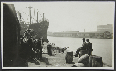
Photograph - Photograph, Black and white, Reverend John Reginald Weller, On the Australian Wharf, c. 1925
Black and white photograph with a thin white border depicting the Australian wharf: two horses, steam ship, two men one siting on a barrel. Across the Yarra river: docks and in the background, the Robur Tea House.Stamps: In purple ink: Herschell's Print, Pathe Agents / in blue ink: "384" Handwritten in black ink and in pencil: "6" australian-wharf, yarra-river, robur tea house, weller album -
 Glenelg Shire Council Cultural Collection
Souvenir - Carmel Wallace's 'Illuminated by Fire' project performance in Melbourne, July 2011, Carmel Wallace, Artist; photo: Grant Wallace, ILLUMINATED BY FIRE, 2011
Printed flyer, Carmel Wallace's 'Illuminated by Fire' project performance in Melbourne, July 2011. Photo of replica New Zealander on Yarra river at night, with fireworks exploding. Reverse has history of project, and sponsors' logos. -
Glenelg Shire Council Cultural Collection
Photograph - Sheet of 2 contact prints from glass plate negatives, 1960-1970
Sheet of 2 contact prints from glass plate negatives. Each print measures 12 x 16 cm Top: Crowd at Portland Show. Bottom: River flowing through heavily wooded banks. -
 Halls Gap & Grampians Historical Society
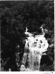
Photograph - B/W, C 1960s
A Forestry Commission photo of MacKenzie Falls.Photo shows a large waterfall (MacKenzie Falls), taken from a fairly high vantage point. The river comes into the falls in two separate streams and there is a large volume of water flowing. The falls are surrounded by thick bush."Publicity & Public Relations branch. When reproducing please Acknowledge FORESTS COMMISSION, VICTORIA. Negative No. 322-2" stamped on rear (except negative number, which is hand written in pen)scenery, mackenzie falls -
 Orbost & District Historical Society
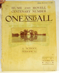
magazine, Clothier & Co, One And All, 1924
This magazine was circulated amongst the pupils, parents, and teachers of the Beechworth Inspectorate, North-East Victoria. This magazine is Vol. 2, no. 3 (Oct. 1924), Hume and Hovell Centenary Number.School magazines were the forerunners of today's school newsletters and were generally published annually. They are contemporary records of the students and staff of the school and usually contain examples of the students' work.This one, published to commemorate the centenary contains information on the Hume and Hovell expedition the purpose of which was to find new grazing land in the south of the colony, and also to find an answer to the mystery of where New South Wales's western rivers flowed. At the centenary of Hume and Hovell exploration in 1924 a committee was formed to co-ordinate and organise local celebrations along the route from Albury to Corio Bay. A roadside cairn was unveiled near Beechworth.A stapled school magazine with a cream coloured cover. It has an illustration of a river and trees reflected in the water on the front. The title, "ONE AND ALL" is at the top in black print. It has " Hume and Hovell Centenary Number" above the title.education-beechworth school-magazine-one-and-all -
 Port Melbourne Historical & Preservation Society
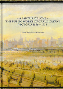
Book, Isaac Douglas Hermann, A Labour of Love The Public works of Carlo Catani Victoria 1876 - 1918, October 2021
The book covers all the Victorian Public Works projects of Carlo CATANI including the Catani Memorial Clock Tower & the Catani Gardens in St Kilda. Book, 'A Labour of love - the Public Works of Carlo Catani Victoria 1876 - 1918'. The front & back covers are from a 1905 painting by Laurence WILSON showing the southern approach to Melbourne and with Princes Bridge and the Yarra River.carlo catani, carlo catani memorial clock tower, catani gardens -
 Bendigo Historical Society Inc.
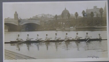
Photograph - PHOTOGRAPH OF ROWING TEAM, 1920
Black and white photograph of an 8 man rowing team on the Yarra River Melbourne showing city buildings in the background, mounted on grey card within a thin black wooden frame, markings read 'Burlington Melb'Burlington Melborganization, club/society, rowing team, rowing team, yarra river, burlington -
Tatura Irrigation & Wartime Camps Museum
Book, Methodist Church in Goulburn Valley - 1873 - 1977, 1977
To record the history of Methodist Churches in Goulburn Valley. As now it will be called the Uniting Church from 1977. Includes history of Tatura Methodist ChurchBlack and white cover. Picture of Methodist picnic at Goulburn River 1896 - top of front cover and picture of centenary service 30th September, 1973. Site of Furphy's blacksmith shop - 1st service held in 1873.methodist churches in goulburn valley, tatura methodist church, uniting churches in victoria, history of methodist church -
Nillumbik Shire Council
Mixed Media (installation): John R. NEESON (b.1956 AUS), John R Neeson, Riverbend Project, 2015
John R Neeson was a Laughing Waters Artist in Residence in 2015. During his residency Neeson made site specific trompe-l’oeil paintings and time based videos that referenced the changes of light upon the Knox architecture and the environment of Laughing Waters.Wooden easel holding an oil on board painting of the Yarra River and surrounding landscape at Laughing Waters (detailed view). Behind the painting and easel is a digital photograph of the painting and easel in situ in the landscape. The photograph is printed on aluminium. No inscriptions and markingsekphrasis 2016, neeson, easel, oil painting, yarra river, digital photograph, landscape, in situ, site specific, riverbend -
 Kew Historical Society Inc
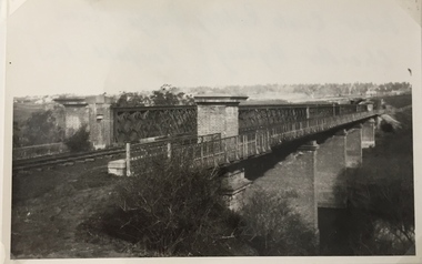
Photograph, Railway Viaduct, c.1919
The railway viaduct linking Kew and Fairfield was created for the Outer Circle railway.Railway viaduct, Yarra River, linking Kew and Fairfield. Built by John Monash for the Outer Circle Railway. In 1930 converted into the Chandler Highway Bridge for vehicular traffic. The point-of-view of the photograph shows Kew in the distance. Annotations on reverse: "Outer Circle Railway Bridge (now Chandler Highway) Fairfield-Kew, about 1919. Property of Miss Foley.outer circle railway, railway viaduct (kew), john monash -
Beechworth Honey Archive
Map- Beechworth
(3x) Map centred on Everton, Beechworth and Eldorado. Map shows Ovens River, Wangaratta- Beechworth Rd., Chiltern- Beechworth Rd., and Ovens Highway. Scale 1:50,000. Back of map white, front is yellow.Albury series R.652 (Beechworth) Two copies have towns shaded red. One copy has locations of dams marked. ca 1974-1975.map, beechworth, everton, eldorado, paper, beechworth honey -
University of Melbourne, Burnley Campus Archives
Photograph - Black and white print, Aerial View of Burnley Campus, 1977
Framed enlargements. (A) Burnley College and surrounding suburbs showing the nearly constructed Freeway, the College in the bend of the Yarra River, Glenferrie Road to the East Swan Street to the North. (B) Enlargement of (A) showing detail of Burnley College.burnley college, suburbs, freeway, yarra river, glenferrie road, east swan street, aerial view -
 Tarnagulla History Archive
Photograph: Simpsons Store and Hotel, Newbridge after flood, Simpsons Store and Hotel, Newbridge after flood, 1909 (original image)
In this image, store merchandise, including drapery, is hung out to dry after the flood. On 20th August,1909 the Laanecoorie Weir broke away and released 18.3 million cubic metres of water through the opening and causing severe damage to all towns downstream. At Newbridge, Petersen's bakery collapsed and Simpson's Store and Hotel flooded to the roof. The billiard table was later found in a tree five miles down the Loddon near Learmonth. Murray Comrie Collection. Monochrome photograph, image depicting buildings in the area near Loddon River at Newbridge after major flood in 1909. This is a very grainy and dark copy of an older original. Copy probably made by Murray Comrie in the 1960s.newbridge, loddon river, flood, simpson, stores, hotels -
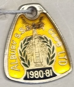 Wodonga & District Historical Society Inc
Badge - Membership Albury S.S & A, Perfection Badges, 1980 - 1981
The Albury Sailors, Soldiers and Airmen’s Club traces its origins back to the Albury and District War Services Hall Appeal Committee. This group of the World War I diggers, service groups and parents of men serving in World War II set out to raise 14,000 pounds for a Services Memorial Hall. After the war ended, the Memorial Hall Fund was far short of its target. Also, different attitudes prevailed when the boys came home. Instead of a memorial hall, the idea of a licensed club gained favour. This was to be not merely for RSL men who had served overseas, but for many ex-servicemen who had not left Australia. Using the Memorial Hall Fund, the RSL bought the old Commercial Club buildings at 611 Dean Street, which had been a Service Rest Room throughout the war and up to February 1946. The SS&A Club was formally opened in October 1946 and was registered under the Liquor Act in 1947. The foundation stone of the new building in Olive Street was laid by Lt General Sir John Northcott, May 2, 1959. The building was opened July 15,1960 by Governor of NSW, Sir Eric Woodward. It has since undergone many extensions and developments to become a modern facility but still continues to honour its origins with the inclusion of its War MemorialThis badge is representative of the role played by licensed clubs in the local community.Enamelled membership badges for the S.S & A. Club in Albury. Many people from both Albury and Wodonga hold membership the club which provides employment and social activities for people from both sides of the Murray RIver.Red Badge, around the centre image of the Albury War Memorial: "ALBURY S.S.& A CLUB LTD/ 1981-82" On reverse: "MEMBER/NOT TRANSFERABLE/2302/PERFECTION BADGES/SYDNEY/770775" Yellow Badge, around the centre image of the Albury War Memorial: "ALBURY S.S.& A CLUB LTD/ 1980-81"albury s.s & a club, social clubs, licensed clubs albury -
 Wodonga & District Historical Society Inc
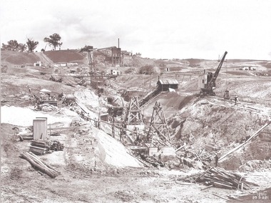
Album - Hume Reservoir Australia Album - Excavation for Foundations of Core Wall September 1922
This set of photos is from a leather bound album bearing the inscription "HUME RESERVOIR AUSTRALIA" plus 'The Rt. Hon. L. C. M. S. Amery, P. C., M .P.' all inscribed in gold. It was presented to The Rt. Hon. L. C. M. S. Amery, P. C., M. P, Secretary of State for Dominion Affairs on the occasion of his visit to the Hume Reservoir on 2nd November 1927. This album is of local and national significance as it documents the planning and development of the Hume Reservoir up to 1927. It was the largest water reservoir in the British Empire. The album records the pioneering engineering work that went into its construction.DEPARTMENT OF PUBLIC WORKS, N.S.W. RIVER MURRAY WATERS SCHEME. HUME RESERVOIR. 9. Excavations for foundations of core wall (in foreground) and part of core wall and earth embankment constructed (in background) in Victoria, September 1922.hume reservoir australia, river murray waters scheme, excavation hume reservoir -
 Wodonga & District Historical Society Inc
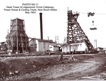
Album - Hume Reservoir Australia Album - Head tower of Lidgerwood, Power House and Cooling Tower May 1923
This set of photos is from a leather bound album bearing the inscription "HUME RESERVOIR AUSTRALIA" plus 'The Rt. Hon. L. C. M. S. Amery, P. C., M .P.' all inscribed in gold. It was presented to The Rt. Hon. L. C. M. S. Amery, P. C., M. P, Secretary of State for Dominion Affairs on the occasion of his visit to the Hume Reservoir on 2nd November 1927. This album is of local and national significance as it documents the planning and development of the Hume Reservoir up to 1927. It was the largest water reservoir in the British Empire. The album records the pioneering engineering work that went into its construction.DEPARTMENT OF PUBLIC WORKS, N.S.W. RIVER MURRAY WATERS SCHEME. HUME RESERVOIR. 11. Head tower of Lidgerwood 10-ton Cableway, Power House and Cooling Tower, New South Wales, May 1923. hume reservoir australia, river murray waters scheme, head tower hume reservoir -
 Sunbury Family History and Heritage Society Inc.
Photograph, Jacksons Creek
The photograph of the waterfall tumbling over rocks in the Jacksons Creek are a feature downstream from the Macedon Street bridge and Craiglee when the there has been high rainfall. The steep escarpment on the LHS leads to Jacksons Hill and the line of trees in the distance are growing along Macedon Street (Sunbury Road).After heavy rainfall, Jacksons Creek rises suddenly and small trickles over the rocky outcrops become fast flowing waterfalls.A non-digital sepia photograph backed onto thick cardboard of a waterfall tumbling over rocks in a river with a high escarpment rising up from the watercourse. There are rocky outcrops across the hillside with a pipe down the hillside. jacksons creek, jackson hill, waterfalls, rivers -
 Lakes Entrance Historical Society
Photograph - Rotary, Lakes Post Newspaper, 1999
Colour photograph three members Mitchell River Rotary Club David Neal, John Butler and Norn Neilson winners of Great Debate with Rotarian Lance Newman and adjudicator Chris Fenner. Lakes Entrance Victoriarotary club, volunteering, debating -
 Lakes Entrance Historical Society
Photograph - Snake Island, 1950c
Also two other copies 7 x 11Black and white photograph showing eastern end of Rigby Island, Snake Island, and dunes at Lakes Entrance, Victoria. Reeves River below, foreground bushes, Hopetoun Channel in middle distance, Bass Strait in distance. waterways, topography, islands -
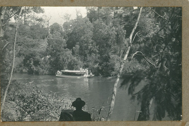 Lakes Entrance Historical Society
Photograph - MV Maranui, 1930 c
Black and white photograph showing Broomes launch Maranui in Tambo River (?) Thick vegetation on either bank. Several people on boat, one man centre lower edge on the bank watching. Swan Reach VictoriaBroome's Launch (written on back)waterways, boats and boating, tourism -
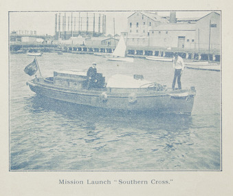 Mission to Seafarers Victoria
Photograph, Mission Launch Southern Cross, c. 1910
The motor boat built by Charles Blunt was donated in 1906, and was useful for ships' visit.Printed photograph published in the Annual Report for 1910 on page 35, depicting Reverend Alfred Gurney Goldsmith on board the mission's motor boat with another man. The image was taken on the Yarra River near the Docklands Gasworks.alfred gurney goldsmtih, motor boat, motor launch, southern cross, yarra river, gasworks, docklands, flinders street, charles blunt, blunt boatbuilders, geelong -
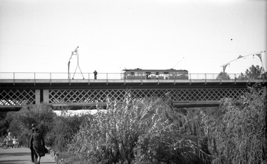 Melbourne Tram Museum
Negative, Wal Jack, c1941
Black and white negative, by Wal Jack, of W2 392 (from information in the Wal Jack Album) crossing the Swan St or Wallen St bridge over the Yarra River. Photo not dated, in the Wal Jack album.trams, tramways, swan st, wallen road, bridges, w2 class, yarra river, tram 392 -
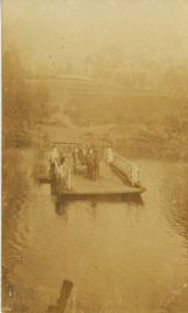 Lakes Entrance Historical Society
Postcard, Tambo Upper Punt, 1900 c
Faded postcard showing the river punt at Tambo Upper with horse and jinker on board also several people. View is looking east towards Redenbachs house and Swan Reach Bruthen road Tambo Upper Victoriatransport, waterways -
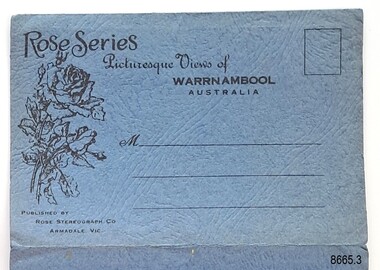 Flagstaff Hill Maritime Museum and Village
Postcard - Postcard Folder, scenes, George Rose, Rose Stereographic Company, Rose Series Picturesque Views of Warrnambool Australia, 1880-1942
GEORGE ROSE 1861-1942: - George Rose was a well-known Victorian photographer, famous for his late 19th and early 20th century photography. He was born in Clunes, Victoria, and was in his 20th year when he founded Rose Stereograph Company in 1880. He took the opportunity of a popular trend of the times to produce stereographs, pairs of almost duplicate photographs that appeared in 3D when viewed in a handheld stereo viewer. By the 1920s, these lost their popularity, so he used his photographic skills to produce cards and postcards of scenes and people. The twelve photographs in the Rose postcard folders include locations connected to other items in our Collection, including the Valentine postcard folder in this set. The photographs are titled: - . The Avenue and War Memorial. Warrnambool. Vic. . The Blow-hole. Thunder Point. Warrnambool. Vic. . Botanical Gardens. Warrnambool. Vic. . Eagle Rock. Warrnambool. Vic. . The New Concrete Bridge and Breakwater. Warrnambool. Vic. . Liebig Street. Warrnambool. Vic. . Looking to Thunder Point. Warrnambool. Vic. . The Beach. Warrnambool. Vic. . Hopkins Falls. Warrnambool. Vic. . Shelly Beach. Warrnambool. Vic. . The Mouth of the Hopkins River. Warrnambool. Vic. . Panorama of Warrnambool, Vic. [Kepler Street towards Presbyterian Church on Spence St] The photographs in this postcard folder were taken between 1880 and 1942 by the renowned Victorian photographer George Rose. The locations match photographs and postcards in our collection that were taken at different times. A comparison between them shows the changes over time in the land and bay, the buildings and other structures, transportation and even the fashions of the times, building the story of our local history.Postcard folder, Rose Series, blue cover. One of a set of three containing images of Warrnambool and district before 1942. Green folder, textured cardboard folder containing a Z-folded strip of white matte photographic paper with six black and white photographs on each side. Titles are printed below the images. The folder is secured by placing two tabs into two slots on the back cover to hold the cover in place and create an envelope shape. Three horizontal lines are printed on the front for the receiver’s address. There is a logo of a long-stemmed rose on the left side and inscriptions on the front cover. The lithograph photographs were taken between 1880 and 1942 by well-known Victorian photographer George Rose and published by Rose Stereograph Company of Armadale, Victoria. The folder contains scenes of popular areas at Warrnambool and nearby locations including Lady Bay, the Port of Warrnambool, the Warrnambool Breakwater, the Viaduct, the Merri River Footbridge, the Hopkins River Mouth, and Proudfoot’s and the Fanny Nelson/Flett boathouses. Image: [Rose with rosebud and leaves] Printed: "Rose Series / Picturesque Views of / WARRNAMBOOL / AUSTRALIA" "PUBLISHED BY / ROSE STEREOGRAPH CO / ARMADALE. VIC." flagstaff hill maritime museum and village, great ocean road, shipwreck coast, warrnambool, flagstaff hill, flagstaff hill maritime museum, flagstaff hill maritime village, warramble, postcard, postcard folder, warrnambool scenes, picturesque views of warrnambool, picturesque views of warramble, lady bay, port of warrnambool, breakwater, warrnambool breakwater, viaduct, merri river footbridge, merri river suspension bridge, suspension footbridge, merri river mouth, hopkins river mouth, proudfoot's, fanny nelson, nelson's boatsheds, nelson's boathouse, boathouse, hopkins river boathouses, flett's boathouse, flett, george rose, image of a rose, rose series, rose stereograph co, rose stereographic company, lighograph, armadale victoria, lady bay beach, beach scene, lower light, concrete footbridge, 1922 footbridge, viaduct road, rose postcard, new concrete bridge, 1945, 1890, 1922, small footbridge, 1872 footbridge, 1872, merri river estuary, stingray bay, postcards -
 Warrnambool and District Historical Society Inc.
Postcard - Views of Warrnambool
Pictures depicting scenes of Warrnambool & District. 9 pictures are, The Beach. Hopkins River. Thunder Point. Liebig St. Botanical Gardens. Breakwater and pier. Hopkins River. Soldiers Memorial. Hopkins Falls.A typical souvenir postcard from the 1930'sOblong postcard with flip down views of Warrnambool from a purse with two kittensValentine's Mail Novelty Post Card; Good Luck And a Bagful of Views from WARRNAMBOOLwarrnambool, hopkins river, warrnambool breakwater, warrnambool postcards, postcards, hopkins falls, thunder point, soldiers memorial -
Tatura Irrigation & Wartime Camps Museum
Book, The Supply of Water for Irrigation in Victoria 1881-1981, 1981
Includes history of early irrigation schemes, Goulburn system, river Murray system, Post war expansion, drainage and salinity. Change from State Rivers & Water Supply Commission to Rural CommissionCream cover, black writing. Cover photo of early days of irrigation, many channels constructed by teams of horses dragging scoops.sr & wscommision, books, rural, industry -
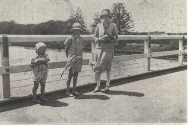 Port Fairy Historical Society Museum and Archives
Photograph
Family standing on Moyne River bridgeBlack and white family photograph bridge, moyne river, famiily, children, mother, traffic, car -
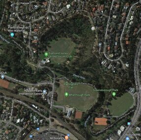 Greensborough Historical Society
Aerial Photograph - Digital Image, Greensborough central with modern landmarks, 2015_
Aerial photograph of Greensborough showing modern landmarks and businesses, including Partington's Flat, Whatmough Park, Plenty River Trail. Bounded by Diamond Creek Road to the East and the Plenty River to the East, The Circuit to the South. Aerial photograph in colour with overlay text indicating modern landmarksgreensborough, manatunga circuit greensborough, plenty river, diamond creek road greensborough, the circuit greensborough, aerial photograph